Preferred Options Core Strategy and Policies Development Plan Document (DPD) Review
(1) Part E: Appendices
APPENDIX 1
A LIST OF POLICIES INCLUDED IN THIS DOCUMENT
PART B: The Strategy
Strategic Spatial Approach
Policy ISPA1 Growth in the Ipswich Strategic Planning Area
Policy ISPA2 Strategic Infrastructure Priorities
Policy ISPA3 Cross-boundary Mitigation of Effects on Protected Habitats and Species
Policy ISPA4 Cross-boundary Working to Deliver Sites
Policy CS1: Sustainable Development - Climate Change
Policy CS2: The Location and Nature of Development
Policy CS3: IP-One Area Action Plan
Policy CS4: Protecting our Assets
Policy CS5: Improving Accessibility
(Policy deleted)
Live
Policy CS7: The Amount of New Housing Required
Policy CS8: Housing Type and Tenure
Policy CS10: Ipswich Garden Suburb
Policy CS11: Gypsy and Traveller Accommodation
Policy CS12: Affordable Housing
Work
Policy CS13: Planning for Jobs Growth
Policy CS14: Retail Development and Main Town Centre Uses
Learn
Policy CS15: Education Provision
Play
Policy CS16: Green Infrastructure, Sport and Recreation
Infrastructure
Policy CS17: Delivering Infrastructure
Policy CS18: Strategic Flood Defence
Policy CS19: Provision of Health Services
Policy CS20: Key Transport Proposals
PART C: Development Management Policies
Policy DM1: Sustainable Construction
Policy DM2: Decentralised Renewable or Low Carbon Energy
Policy DM3: Air Quality (new)
Policy DM4: Development and Flood Risk
Policy DM5: Protection of Open Spaces, Sports and Recreation
Policy DM6: Provision of New Open Spaces, Sports and Recreation Facilities
Policy DM7: Provision of Private Outdoor Amenity Space in New and Existing Developments
Policy DM8: The Natural Environment
Policy DM9: Protection of Trees and Hedgerows
Policy DM10: Green Corridors
Policy DM11: Countryside
Policy DM12: Design and Character
Policy DM13: Built Heritage and Conservation
Policy DM14: Archaeology (divided out)
Policy DM15: Tall Buildings
Policy DM16: Extensions to Dwellings and Provision of Ancillary Buildings
Policy DM17: Small Scale Infill and Backland Residential Developments
Policy DM18: Protection of Amenity
Policy DM19: The Subdivision of Family Dwellings
Policy DM20: Transport and Access in New Developments
Policy DM21: Car and Cycle Parking in New Development
Policy DM22: The Density of Residential Development
Policy DM23: Protection and Provision of Community Facilities
Policy DM24: Shopfront Design (new)
Policy DM25: Advertisement (new)
Policy DM26: The Central Shopping Area
Policy DM27: Arts, Culture and Tourism
Policy DM28: The Evening and Night-time Economy (new)
Policy DM29: District and Local Centres
Policy DM30: Town Centre Uses Outside the Central Shopping Area
Policy DM31 Retail Proposals Outside Defined Centres
Policy DM32: Protection of Employment Land
Policy DM: Delivery and Expansion of Digital Communications Networks (new)
Deleted policies
The following policies have been deleted and material incorporated into other policies as appropriate:
Buildings and Structures of Townscape Interest
Non-residential Uses in Residential Areas
APPENDIX 2
Saved Policies that are superseded by the Core Strategy and Policies Development Plan Document
In addition to the Core Strategy and Policies Development Plan Document, national policy (particularly the NPPF may also have a role in replacing policy contained in saved policies. Elements of the Saved Local Plan Policies may also be carried forward into other development plan documents.
TABLE 9
|
Policy |
Policy subject matter |
Comments |
|
Chapter 5 The Wet Dock Area |
||
|
WD3 |
Site allocations in the Wet Dock area |
|
|
WD4 |
Links between Wet Dock and town centre |
Detailed proposals if appropriate would be considered through the Site Allocations Development Plan Document but see also Core Strategy policy CS20 |
|
WD5 |
Site allocations in the Transition area |
|
|
WD7 |
Residential site allocation in Wet Dock area |
|
|
WD8 |
Public access to water frontages |
See also Core Strategy policy CS16 |
|
WD9 |
Wet Dock area open space allocation |
|
|
WD10 |
Wet Dock area provision of open space in developments |
|
|
WD11 |
Wet Dock area museums, arts and entertainment uses |
|
|
WD12 |
Wet Dock area tourism uses |
|
|
WD13 |
Wet Dock area community uses |
See also Core Strategy policy CS3 |
|
WD14 |
Wet Dock area University College Suffolk |
Any further land allocations if appropriate would be considered through the Site Allocations Development Plan Document but see also Core Strategy policy CS15 |
|
WD15 |
Wet Dock area employment |
|
|
WD16 |
Transition area |
|
|
WD17 |
Wet Dock office uses |
|
|
WD18 |
Shopping in the Wet Dock area |
See also Core Strategy policy DM23 |
|
WD19 |
Pedestrian access between the Wet Dock and the town centre |
Detailed proposals if appropriate would be considered through the Site Allocations Development Plan Document but see also Core Strategy policy CS20 |
|
WD20 |
Car parking in the Wet Dock area |
|
|
WD21 |
Road Proposal in the Wet Dock area |
The need for an allocation to safeguard the route will be considered through the Site Allocations Development Plan Document but see also Core Strategy policy CS20 paragraphs 8.203 to 8.205 |
|
Chapter 6 Housing |
||
|
H3 |
Housing allocation Nacton Road |
Will be replaced if there is any land remaining through the Site Allocations Development Plan Document |
|
H4 |
Residential site allocations |
Will be replaced if there is any land remaining through the Site Allocations Development Plan Document |
|
H5 |
Protecting residential allocations |
|
|
H6 |
Opportunity sites for residential use |
Will be replaced if there is any land remaining through the Site Allocations Development Plan Document |
|
Chapter 7 Recreation and Leisure |
||
|
RL8 |
Site allocations for public open space |
The need for allocations for new open space will be considered through the Site Allocations Development Plan Document but see also Core Strategy policies CS10 and CS16 |
|
RL11 |
Site allocations for children's play |
The need for allocations for new children's play areas will be considered through the Site Allocations Development Plan Document |
|
RL16 |
Site allocations for sports pitches |
The need for allocations for new open space will be considered through the Site Allocations Development Plan Document but see also Core Strategy policies CS10 and CS16 |
|
RL19 |
Site Allocation for Sports Park |
|
|
RL23 |
Protecting museums, arts and entertainment facilities |
|
|
RL24 |
Arts and entertainment uses in major developments |
|
|
Chapter 8 Community Facilities |
||
|
CF9 |
Site allocations for education facilities |
|
|
Chapter 9 Employment |
||
|
EMP2 |
Employment Areas |
|
|
EMP5 |
Sites allocated for employment use |
|
|
EMP7 |
Sites allocated for port related uses |
|
|
Chapter 11 Transport |
||
|
T7 |
Pedestrian Priority Areas |
|
|
T14 |
Site allocations for short stay parking |
|
APPENDIX 3
COMMUNITY FACILITIES IN DISTRICT AND LOCAL CENTRES
The list below sets out some of the community facilities that the Council considers are appropriate in or within 400m straight-line distance of the District and Local Centres, provided certain criteria are met.
- Health Facilities including doctors surgeries and dentists;
- Education facilities including schools, nurseries, crèches and lifelong learning;
- Parks / open spaces and play facilities;
- Community meeting places or drop in centres;
- Libraries;
- Local service providers (e.g. local authority offices and police facilities);
- Places of Worship;
- Housing for people with special needs;
- Vets.
(1) APPENDIX 4
ACTIVITIES OR SERVICES RELEVANT TO EACH PLANNING STANDARD CHARGE HEADING
The broad categories of infrastructure to be included in the standard charge are as follows. This does not constitute a precursor to a CIL Regulation 123 List.
Highways and Transport
- Highway infrastructure
- Public Transport
- Transport/travel information
- Pedestrian/cycle routes including public rights of way
- Cycling facilities
- Parking
- Park and Ride
- Street Lighting
- Pedestrian facilities
- Street scene improvements
- Signing
- Traffic calming
Childcare, Early Years and Education
- Nurseries and pre-school
- Schools
- Adult Education
- University Campus Suffolk
- Suffolk New College
Health and Emergency Services
- Health Facilities
- Social Care/Day care
- Public health and prevention
- Fire
- Ambulance
- Police
Environment and Conservation
- Public Realm Improvements
- Waste Management
- Recycling
- Refuse collection and disposal
- Sustainable Urban Drainage Systems
- Flood Risk
- Flood defence
- Air Quality
- Archaeological Remains
- Historic Buildings
- Conservation Area Improvements
- Nature Conservation
- Historic Parks restoration
Community and Cultural Facilities
- Safer Neighbourhood Teams and policing
- Street Lighting
- CCTV
- Libraries
- Cemeteries and crematoria
- Community Buildings
- Community Projects
- Youth facilities (not picked up under sport and recreation)
- Voluntary Sector Groups and Initiatives
- Places of worship
- Children's services
- Older people's services
Sport and Recreation
- Parks and gardens
- Amenity greenspace
- Children's Play Space
- Facilities for young people
- Outdoor Playing Pitches
- Indoor Sports Facilities
- Outdoor Sports Facilities
- Allotments
- River Corridor and other green corridor Improvements
- Natural and semi natural greenspace including woodlands and country parks
- Civic spaces
Economic Development
- Inward Investment
- Business support services
- Skills training
Utilities
- Super-fast broadband
- Telephone
- Gas
- Electricity
- Water
(1) APPENDIX 5
IPSWICH STANDARDS FOR THE PROVISION OF OPEN SPACE, SPORT AND RECREATION FACILITIES
TABLE 10
|
Typology of open spaces, sport & recreation facilities |
Quantity Standard |
Accessibility Standard |
|
1. Parks & Gardens |
1.16ha per 1000 popn |
15 minute walk time |
|
2. Amenity Green Space |
0.48ha per 1000 popn |
10 minute walk time |
|
3. Natural and Semi Natural Green Space |
1.53ha per 1000 popn |
15 minute walk time |
|
4. Outdoor Sports Facilities |
1.42ha per 1000 popn |
15 minute walk time |
|
5. Provision for Children e.g. Local Areas of Play, Local Equipped Areas for Play and Neighbourhood Equipped Areas for Play – LEAPs, NEAPs and DEAPs. |
0.08ha per 1000 popn |
10 minute walk time |
|
6. Provision for Young People e.g. teen shelters, multi-use games areas |
0.04ha per 1000 popn |
15 minute walk time |
|
7. Allotments |
0. 41ha per 1000 popn Should also have reference to Council waiting lists to indicate demand |
15 minute walk time |
|
8. Cemeteries & Churchyards |
Standard not appropriate |
Standard not appropriate |
|
9. Ecological networks |
Standard not appropriate |
Standard not appropriate |
|
10. Civic Spaces |
Standard not appropriate |
Standard not appropriate |
For quality standards for types 1 to 9 above, please refer to the Ipswich Open Space, Sport & Recreation Study 2009 (reviewed in 2013, updated in 2017)
APPENDIX 6
GLOSSARY
|
Abbreviation |
Term in full |
|
|
|
Active frontage Adoption |
Ground floor building frontage that is in use, for example as a restaurant or shop. The final confirmation of a plan as a statutory document by the local planning authority. |
|
|
Affordable Housing |
Affordable housing includes affordable housing for rent and starter homes, discounted market sales housing and other affordable home ownership, provided to specified eligible households whose needs are not met by the market. |
|
|
Amenity |
Pleasantness of a place or circumstance. For planning purposes residential amenity is usually taken to include attributes such as privacy, access to daylight and sunlight, and absence of noise pollution. It does not include property values. |
|
AMR |
Annual Authority Monitoring Report |
Reports progress with preparing the Local Plan and the extent to which policies are being achieved. |
|
AA |
Appropriate Assessment |
An appropriate assessment, also known as a habitat regulations assessment, is the process of considering emerging policies against the habitats directive. |
|
AAP |
Area Action Plan |
A type of development plan document relating to specific areas of major opportunity and change or conservation. |
|
|
Area of Archaeological Importance |
The Area of Archaeological Importance is a defined area where there is suggested to be significant known or a high potential for complex and sensitive archaeological deposits. It is based upon available evidence of buried archaeology, historic maps and information, standing structures and visual elements of the historic landscape. Within the local plan context, it is intended to alert applicants and planning officers to the likely requirements for archaeological investigation, protection and recording to be placed on development, on potentially even the smallest scale below-ground works. |
|
AONB AQMA |
Area of Outstanding Natural Beauty Air Quality Management Areas Ancient or veteran trees |
A site with a statutory national landscape designation to provide special protection for the area's natural beauty. Designated by Natural England, the primary objective is to conserve the natural beauty of the landscape. Areas designated by local authorities because they are not likely to achieve national air quality objectives by the relevant deadlines. A tree which, because of its age, size and condition, is of exceptional biodiversity, cultural or heritage value. All ancient trees are veteran trees. Not all veteran trees are old enough to be ancient, but are old relative to other trees of the same species. Very few trees of any species reach the ancient life-stage. |
|
|
Biodiversity |
The variety of life on earth or in a specified region or area. |
|
BAP |
Biodiversity Action Plan |
It is the UK Government's response to signing the Convention on Biological Diversity (CBD) at the 1992 Rio Earth Summit. The plan sets out a programme for conserving the UK's biodiversity, at national and local levels. The Suffolk Local Biodiversity Action Plan (Suffolk LBAP) is applicable for the county of Suffolk. |
|
BfL 12 |
Building for Life 12 |
Building for life is a partnership between several national agencies, which sets standard for well-designed homes and neighbourhoods. It is led by CABE at the Design Council, Design for Homes and the Home Builders Federation. |
|
BREEAM |
Building Research Establishment Environmental Assessment Method |
It is a tool that allows the owners, users and designers of buildings to review and improve environmental performance throughout the life of a building. |
|
BID |
Business Improvement District Brownfield sites Brownfield Land Register |
It is a public-private partnership in which businesses in a defined area elect to pay an additional tax in order to fund improvements to the district's public realm and trading environment. In Ipswich the BID is called Ipswich Central. Development site on previously developed land. Registers of previously developed land considered to be appropriate for residential development, having regard to criteria in the Town and Country Planning (Brownfield Land Registers) Regulations 2017. |
|
CRed |
Carbon Reduction |
Community Carbon Reduction Project is based in the East of England and is addressing the biggest environmental challenge of Climate Change. CRed is building a community of partners who are deciding how they want to cut their emissions of carbon dioxide (CO2) to meet a target of 60% reduction by 2025. |
|
|
Circular |
A Government publication setting out policy approaches. |
|
|
|
|
|
CABE |
Commission for Architecture and the Built Environment |
CABE was until 31st March 2011 a statutory body sponsored by the Government. On 1st April 2011 it was merged with the Design Council, to become an advisor on design in business innovation and the built environment. |
|
CIL |
Community Infrastructure Levy |
Local authorities will be empowered to set a charge for most developments, through a simple formula related to the scale and type of scheme. The proceeds of the levy must be spent on local and sub-regional infrastructure to support the development of the area. |
|
|
Community Strategy |
Strategy for promoting the economic, environmental and social well-being of the area and contributing to the achievement of Borough wide sustainable development. |
|
|
Comparison shopping |
Comparison retailing is the provision of items not obtained on a frequent basis. These include clothing, footwear, household and recreational goods. |
|
|
Convenience shopping |
Convenience retailing is the provision of everyday essential items, including food, drinks, newspapers/magazines and confectionery. |
|
|
Conservation Area |
Defined areas within a local planning authority that are considered to be of special architectural or historic interest, the character and appearance of which it is desirable to preserve or enhance. Conservation area designation introduces a general control over the demolition of unlisted buildings and provides a basis for the conservation of those aspects of character or appearance (including landscape and public spaces) that define the area's special interest. That special character could include elements such as the historic layout of roads, paths and boundaries and characteristic building and paving materials. All the features within the area, listed or otherwise, are recognised as part of its character. Conservation areas are identified in the National Planning Policy Framework as designated heritage assets. |
|
|
Curtilage |
It is the enclosed area of land around a dwelling. It is distinct from the dwelling by virtue of lacking a roof, but distinct from the area outside the enclosure in that it is enclosed within a wall or barrier of some sort. |
|
|
Density of Residential Development |
High density refers to new housing development of at least 90 dwellings per hectare (dph) . Medium density refers to new housing development of at least 40 dph (the average will be taken as 45 dph). Low density refers to new housing development under 40 dph (the average will be taken as 35 dph). |
|
|
Development brief |
Document providing detailed information to guide developers on the type of development, design and layout constraints and other requirements for a particular, usually substantial, site. |
|
|
Development Plan |
Documents setting out the policies and proposals for the development and use of land and buildings. |
|
DPD |
Development Plan Document |
A local development document in the Local Plan which forms part of the statutory development plan. The Core Strategy and Policies is a DPD. |
|
DEAP |
Destination Equipped Area for Play |
Provides a wide range of play equipment, including 'water play', and as such tends to draw people from a wide catchment area. |
|
|
Digital Infrastructure Edge of Centre European Sites |
The entire spectrum of network, computer, and storage functions required for the successful delivery of applications and services in a mobile, digital economy. For retail purposes it is a location that is well connected to and within easy walking distance (up to 300 metres) of the primary shopping area. For all other town centre uses, it is likely to be within 300m of a town centre boundary. For office uses, it may also mean outside the town centre but within 500m of a public transport interchange, within the urban area. This includes Special Areas of Conservation, Sites of Community Importance, Special Areas of Conservation and Special Protection Areas, and is defined in regulation 8 of the Conservation of Habitats and Species Regulations 2010. |
|
|
Geodiversity |
The variety of rocks, fossils, minerals, landforms and soils along with the natural processes that shape the landscape. |
|
|
Green Infrastructure |
Sub regional network of protected sites, nature reserves, green spaces and greenway linkages, including river corridors and flood plains, migration routes and features of the landscape, which are important as wildlife corridors. |
|
|
Green roof |
The term to describe both intensive ornamental roof gardens and extensive roofs with more naturalistic plantings or self-established vegetation, which can provide a habitat for biodiversity. |
|
|
Greenways Project Gypsies and Travellers Heritage Impact Assessment Housing Market Area |
Countryside Management Project for Ipswich and the surrounding area. Persons of nomadic habit of life whatever their race or origin, including persons who on grounds only of their own or their family's or dependents' educational or health needs or old age have ceased to travel temporarily, but excluding members of an organised group of travelling showpeople or circus people travelling together as such. An assessment of the impact upon the historic environment caused by a proposed development. A geographical area defined by household demand and preferences for all types of housing, reflecting the key functional linkages between places where people live and work. |
|
|
IP-One |
Central part of Ipswich including the town centre, the Waterfront, Portman Quarter and the Education Quarter. |
|
|
Ipswich Standard |
A standard applied to all housing owned by Ipswich Borough Council. It includes energy efficiency measures such as efficient combi boilers, double glazing and insulation. |
|
|
Key Diagram |
The key diagram illustrates the spatial strategy set out in the DPD and may show links and relationships with other strategies and neighbouring authorities. |
|
|
Key Worker Legibility |
The Government's definition of key workers includes those groups eligible for the Key Worker Living Programme and others employed within the public sector (ie outside of this programme) identified by the Regional Housing Board for assistance. The extent to which a development or built up area can be navigated by both residents and visitors. |
|
|
Listed Building |
A building or structure designated by the Secretary of State for the Department of Culture, Media, and Sport as being of special architectural or historical interest. |
|
|
|
|
|
LDD LEP |
Local Development Document Local Enterprise Partnership |
A general term for a document in the Local Plan. It includes the Core Strategy and Policies and other development plan documents, and supplementary planning documents. A body, designated by the Secretary of State for Housing, Communities and Local Government, established for the purpose of creating or improving the conditions for economic growth in an area. |
|
LEAP |
Local Equipped Area for Play |
Characteristics include five types of equipment and a small games area. |
|
LNR |
Local Nature Reserve |
Sites of special natural interest which are designated under the National parks and Access to the Countryside Act 1949. |
|
LPA |
Local Planning Authority |
The Local Authority that is empowered by law to exercise planning functions. Normally this is the Borough or District Council. |
|
LSP |
Local Strategic Partnership |
A local strategic partnership is a partnership of stakeholders who develop ways of involving local people in shaping the future of their neighbourhood in how services are provided. They are often single, multi-agency bodies, which aim to bring together locally the public, private, community and voluntary sectors. |
|
NPPF |
Mixed Use Development National Planning Policy Framework |
A well integrated mix of land uses (retail, employment, leisure and other service uses) with decent homes of different types and tenures to support a range of household sizes, ages and incomes. This document sets out the Government's planning policies for England and how these are expected to be applied. It provides a framework within which local and neighbourhood plans can be produced. |
|
NEAP |
Neighbourhood Equipped Area for Play Non-designated Heritage Asset |
Characteristics include eight types of equipment and opportunities for ball games or wheeled activities. A heritage asset that has not been included on any national list. |
|
|
Open space, sport, and recreational facilities |
These are shown in Table 10 of Appendix 5. |
|
|
Out of centre Objectively Assessed Need |
In retailing terms, a location that is not in or on the edge of a centre but not necessarily outside the urban area. An assessment of the amount of new housing, jobs, employment land, retail floorspace and other uses that are likely to be needed within the Borough. |
|
|
Passive House |
A passive house (or Passivhaus) uses the principles of high levels of insulation, avoiding all cold bridging, very good air tightness, and maximising solar gains in an attempt to reduce annual heat demands so that mechanical ventilation and heat recovery systems can be utilised for heating homes, rather than conventional heating systems, which can be omitted. |
|
|
Place shaping |
'Place shaping' is the name the government gives to the role that local authorities have in leading their communities, creating prosperity and fostering local identity and civic pride. It involves working with the local public, voluntary, community and private sectors to develop coordinated strategies to tackle the area's problems, needs and ambitions. |
|
|
Planning Application |
An application for permission from the local planning authority to commence building work or change of use of buildings. |
|
|
Planning Permission |
Approval required for the development of land from the local planning authority. |
|
PPG |
Planning Policy Guidance Note |
Government documents providing policy and guidance on a range of planning issues such as housing, transport, conservation etc. PPGs were being replaced by Planning Policy Statements, which have now been replaced by the National Planning Policy Framework. |
|
PPS |
Planning Policy Statement Policies Map |
Government documents that were replacing PPGs and were designed to separate policy from wider guidance issues. These have replaced by the NPPF. An obligatory component of a local plan showing the location of proposals in the plan on an Ordnance Survey base map for new development plan documents. These were previously referred to as a Proposals Map |
|
PDL |
Previously Developed Land |
It is land that is or was occupied by a permanent structure, including the curtilage of the developed land and any associated fixed surface infrastructure. |
|
|
Primary Frontage |
Primary frontages are lengths of shop frontage within a defined shopping centre (e.g. the Central Shopping Area) that are likely to include the highest proportion of retail uses. |
|
|
Primary Shopping Area Proposals Map |
Defined area where retail development is concentrated, comprising the Primary and Secondary shopping frontage zones. An obligatory component of a local plan showing the location of proposals in the plan on an Ordnance Survey base map. The Ipswich Local Plan (1997) and the Core Strategy and Policies DPD (2011) both have a Proposals Map. The Government now refers to new Proposals Maps as Policies Maps. |
|
|
Public examination |
The process by which an independent Planning Inspector publicly examines the soundness of a DPD and any representations made against it before issuing a report. |
|
|
Ramsar Site |
Wetlands of global importance, listed under the Convention on Wetlands of International Importance (signed in Ramsar, Iran). |
|
|
Regeneration |
Renewal, rehabilitation of former derelict or under used sites. |
|
|
|
|
|
RIGS |
Regionally important geological or geomorphological site |
Sites identified for their geological or geomorphological interest according to certain criteria. They are protected through the statutory development plan. |
|
|
Registered Parks and Gardens |
Gardens and other land considered to be of special historic interest and included on the Register of Parks and Gardens under the Historic Buildings and Ancient Monuments Act, 1953. The majority of sites registered are, or were originally, the grounds of private houses, but public parks and cemeteries are also important categories. Sites are graded I, II* or II along the same lines as listed buildings. The Register is held by Historic England and the List Entry details for all parks and gardens can be viewed online on the National Heritage List for England and appear on the Suffolk Historic Environment Record. Registered parks and gardens are identified in the National Planning Policy Framework as designated heritage assets. |
|
|
Retail Frontages |
A term given to areas within the Town Centre where shopping is the primary function. The front of the shops facing the street is used to calculate the retail frontages within the Core Strategy and Policies Review DPD. The exact frontages are defined through the Central Shopping Area Identified Frontages supplementary planning guidance, which is in the process of being updated. |
|
|
Scheduled Monument |
A nationally important historic building or archaeological site that is included in the Schedule of Monuments kept by the Secretary of State for Culture, Media and Sport and protected under the Ancient Monuments and Archaeological Areas Act 1979. Scheduled monuments are identified in the National Planning Policy Framework as designated heritage assets of the highest significance. The Schedule can be viewed online on the National Heritage List for England, physically inspected at the Historic England Archive in Swindon and appear on the Suffolk Historic Environment Record. |
|
SMC |
Scheduled Monument Consent |
Monument Consent is a legal requirement under Ancient Monument and Archaeological Areas Act 1979 (as amended) for any works which might affect a monument either above or below ground level. It is granted by the Secretary of State for Culture, Media and Sport, on advice from Historic England, who administer the SMC application process on behalf of the SoS. The types of works that require SMC are specified under Section 2 of the 1979 Act. SMC is required regardless of whether or not planning permission is needed or has been obtained. It cannot be given retrospectively and undertaking works before consent has been given is a criminal offence. Metal detecting or geophysical survey on a scheduled monument is also illegal without a licence from Historic England. |
|
|
Secondary Frontage Self-build and Custom-build Housing |
Secondary frontages are lengths of shop frontage within a defined shopping centre (e.g. the Central Shopping Area) where there is more opportunity for a diversity of uses than in primary frontages. Housing built by an individual, a group of individuals, or persons working with or for them, to be occupied by that individual. Such housing can be either market or affordable housing. A legal definition, for the purpose of applying the Self-build and Custom Housebuilding Act 2015 (as amended), is contained in section 1(A1) and (A2) of that Act. |
|
SSSI |
Site of Special Scientific Interest |
An area of land which, in the opinion of Natural England, is of special interest at a national level due to its flora, fauna or geological or physiographical features. |
|
|
Soundness |
Soundness means founded on a robust and credible evidence base and the most appropriate strategy when considered against the reasonable alternatives. For something to be sound is must also be deliverable, flexible and able to be monitored. |
|
|
Spatial Planning |
Spatial planning goes beyond traditional land use planning to bring together and integrate policies for the development and use of land with other policies and programmes which influence the nature of places and how they function. This will include policies which can impact on land use, for example, by influencing the demands on or needs for development, but which are not capable of being delivered solely or mainly through the granting of planning permission and may be delivered through other means. (PPS 1 ODPM, 2004, pp3). |
|
SAC |
Special Area of Conservation |
Sites of European importance for nature conservation designated under the Conservation of Natural Habitats and Wild Flora and Fauna Directive. |
|
SPA |
Special Protection Area |
Sites of European importance for nature conservation designated under the Conservation of Wild Birds Directive. |
|
|
Specialist Frontage |
Specialist frontages are lengths of shop frontage within a defined shopping centre (e.g. the Central Shopping Area) where there is the greatest diversity of uses, particularly including food and drink uses, alongside clusters of specialist retailers. |
|
SCI |
Statement of Community Involvement |
A document which sets out the standards to be achieved in involving the community and other stakeholders in the preparation, alteration and review of local development documents and in significant development management decisions. |
|
SEA |
Strategic Environmental Assessment |
A strategic environment assessment is a generic term used to describe environmental assessment as applied to policies, plans and programmes. The European SEA directive (2001/42/EC) requires a formal environmental assessment of certain plans and programmes, including those in the field of planning and land use. |
|
|
Submission |
The stage of preparation of a development plan document covered by Regulation 22 of the Town and Country Planning (Local Planning) (England) Regulations 2012 It involves submitting a development plan document to the Secretary of State. |
|
SPD |
Supplementary Planning Document |
A local development document that provides further detail of policies in the development plan documents or of saved local plan policies. They do not have development plan status. |
|
SPG |
Supplementary Planning Guidance |
Providing additional guidance expanding policies in a local plan. SPGs will remain relevant where they are linked to saved policies but will ultimately be replaced by supplementary planning documents. |
|
SuDS |
Sustainable Drainage Systems |
A sequence of management practices and control structures designed to drain water in a more sustainable manner than some conventional techniques. Typically these are used to attenuate run-off from development sites. |
|
SA |
Sustainability Appraisal |
Identifies and evaluates social, environmental and economic effects of strategies and policies in a local development document from the outset of the preparation process. It incorporates the requirements of the Strategic Environmental Assessment (SEA) Directive. |
|
|
Sustainable Development |
Development that meets the needs of the present without compromising the ability of future generations to meet their own needs. |
|
|
Town Centre Uses |
Town Centre uses are defined in the National Planning Policy Framework (NPPF) and include retail, leisure, entertainment, intensive sport and recreation, offices, arts, culture and tourism uses. |
|
|
Tests of Soundness Travel Plans |
Statutory Local Development Documents are subject to an Examination in Public by an Inspector appointed by the Secretary of State. The purpose of the Examination is to assess whether the document is 'sound'. This means that those who wish to make a representation seeking a change to the document will need to show how that document is unsound and what needs to be done to make it sound. In order to assess this, the Inspector will assess the document against certain 'Tests of Soundness'. The purpose is to ensure that the whole plan is 'sound' in relation to all the legal and policy criteria it has to meet. Travel Plans are long term management strategies for integrating proposals for sustainable travel into planning. |
|
|
Urban fringe |
Predominantly open land on the edge of an existing urban area. |
|
|
Use Classes Order |
The Town and Country Planning (Use Classes) Order 1987 and subsequent amendments. Uses are defined as follows: A1 Shops A2 Financial and Professional Services A3 Restaurants and cafes A4 Drinking establishments A5 Hot food takeaways B1 Business (Offices (other than those that fall within A2), research and development of products and processes, light industry) B2 General industrial B8 Storage or distribution C1 Hotels C2 Residential Institutions C2A Secure Residential Institutions C3 Dwellinghouses C4 Houses in multiple occupation D1 Non-residential institutions D2 Assembly and Leisure Sui generis - uses not covered by the above including theatres, petrol filling stations, amusement centres, launderettes and taxi businesses. |
(1) APPENDIX 7 MARKETING REQUIREMENTS
1. Introduction
1.1 This Strategy sets out the marketing exercise, which should be carried out prior to considering a change of use or redevelopment of a site in Ipswich.
1.2 The marketing approach would form a key part of any planning application for a change of use or redevelopment and ensure that the viability of the existing use has been fully considered.
1.3 This Strategy form a part of the Draft Ipswich Local Plan Review 2018 and is cross-referenced in polices DM23 (Protection and Provision of Community Facilities), DM28 (District and Local Centres) and DM31 (Protection of Employment Land).
2. The Strategy
2.1 The Council will expect a marketing exercise to be carried out of the site concerned for a minimum of 12 months and it should be pre-agreed in writing with the Council.
2.2 This exercise should take all considerable steps to actively market the site and should consider a number of methods such as site notices, promotion through land or estate agent, advertisement on an estates gazette or through websites and information of all methods used should be provided to the Council.
2.3 As part of the above steps, the Council will expect a for sale/for rent signboard to be erected on the exterior of the property for the duration of the marketing exercise with dated photographs provided as supporting evidence.
2.4 Marketing Particulars should include the following:-
- Internal and external photographs
- Location of the site
- Description of the property marketed
- Terms of lease
- Guide Price/Rent
- Current Planning status
- Services and utilities
- Energy Performance Certificate
- Rateable value and business rates
- VAT status
- Legal and professional costs
- Viewing arrangements
- Contact information for the agent.
2.5 All contact received enquiring about the site should be logged accordingly and monitored. Details of all approaches and offers should be provided to the Council together with full reasons as to why any offer has not been accepted. The Council will require confirmation of names and contact details of all parties expressing an interest or viewing the premises to allow their identity and validity to be checked.
2.6 The site must be marketed at a price consistent with market value for its current use following independent valuation (funded by the developer) by a professional Royal Institution of Chartered Surveyors (RICS) valuer with expertise in the relevant use and who is not engaged to market the property. The site must be marketed for the existing or most-recent use and not under a generic 'all options' use.
2.7 Details should be provided to the Council of the company/person who undertook the marketing exercise.
3. Outcomes
3.1 If after 12 months of marketing the site, there has been no success in selling or letting the site, a report on the full marketing process should be prepared and submitted with a planning application for redevelopment or change of use.
3.2 This Marketing report should contain the following:
- The original marketing strategy and evidence that it was delivered.
- The duration and dates of the marketing campaign.
- A full record of enquiries which were received during the course of the campaign. This should record the date of the enquiry, details of the enquiry, if the property was inspected and why the enquiry was unsuccessful. If any offers were rejected, the grounds on which these were rejected should be provided.
- If a lack of interest was received, evidence should be provided of alternative approaches used to aim to increase interest.
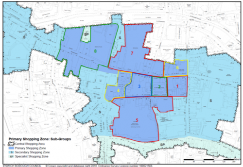
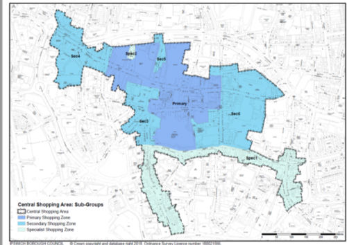
APPENDIX 8: DM26 Central Shopping Area Maps