Final Draft Ipswich Local Plan 2018 - 2036 Sustainability Appraisal Report (SEA and SA)
(5) 3. Stage B: Developing Alternatives and Assessing Effects
3.1 Statutory requirements and best practice for Stage B
3.1.1 During Stage B of SA, options being considered for the Plan were appraised using the SA Framework, in order to predict and evaluate their likely sustainability effects. Appraisal results have been shared and discussed with the Council, along with recommendations for avoiding, mitigating or enhancing effects, through an iterative process, in order to ensure that environmental and sustainability considerations are factored into their decision-making process from the outset.
3.1.2 The statutory requirements for Stage B, which includes Tasks B1 – B6, are as follows:
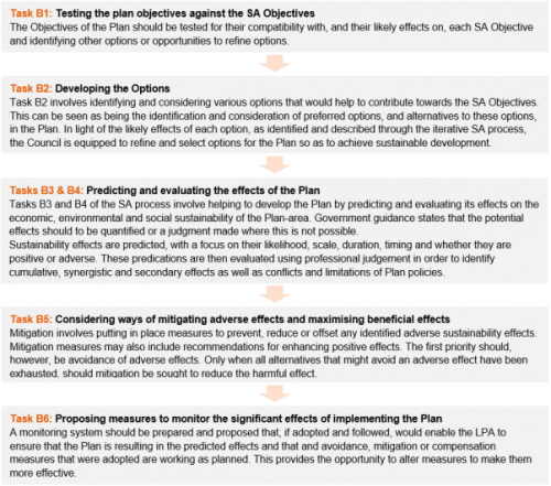
3.2 SA Stage B1 Testing the Plan Objectives against the SA Objectives: Methodology
3.2.1 The Final Draft Ipswich Local Plan document presents a Vision for the Borough by 2036, as well as strategic objectives to help guide the final draft plan and to achieve the Vision. The Vision and the Strategic Objectives were originally appraised for their compatibility with SA Objectives during the SA of the Preferred Options Draft Ipswich Local Plan in January 2019.
3.2.2 The compatibility assessment identified whether the Vision and Strategic Objectives in the Final Draft Ipswich Local Plan would be likely to make a positive contribution towards achieving the SA Objective or if, by adopting that Vision or Strategic Objective, it may make it more difficult to achieve the SA Objective. This was carried out at a high level, with the results presented using the key in Table 3-1. The Vision and 11 Strategic Objectives of the final draft local plan, which have been designed and proposed by the Council in order to help achieve their desired vision for Ipswich, are set out in Table 3-2.
Table 3-1: Assessment key during the compatibility assessment of Plan Strategic Objectives with SA Objectives
|
✓ |
Compatible; achieving the Plan's Vision or Strategic Objective would be highly likely to also contribute towards achieving the SA Objective |
|
x |
Incompatible; achieving the Plan's Vision or Strategic Objective could potentially conflict with efforts to achieve the SA Objective |
|
0 |
No link between the Vision or Strategic Objective and the SA Objective |
|
? |
The link between the Strategic Objective and SA Objective is uncertain. |
3.3 SA Stage B1 Results
3.3.1 On the whole, the Council's Vision and Strategic Objectives proposed for the Final Draft Ipswich Local Plan are highly compatible with the SA Framework and will be likely to help ensure the final draft local plan delivers socially, economically and environmentally sustainable land uses and development until 2036. Uncertainties over the compatibility of Strategic Objective 2 with several of the SA Objectives were recorded. This is because Strategic Objective 2 sets out the desired level of growth in housing and jobs by 2036. The compatibility of this growth with the SA Objectives will be largely dependent on the locations and details of design for each development proposal. This is accounted for during the assessment of sites and site-based policies. Table 3-3 presents the results of the compatibility appraisal. It is noted no changes to the Vision and Strategic Objectives have been made as a direct result of the assessment at this stage.
Our Vision is to improve the quality of life, health and well-being for all who live in, work in, learn in, play in and visit Ipswich, by supporting growth and ensuring that development happens in a sustainable manner so that the amenities enjoyed by local people are not harmed and the town is enhanced.
By 2036, Ipswich town centre will embrace a greater mix of uses providing opportunities for shopping, leisure and cultural activities, learning, working and living. The town centre, Waterfront and Portman Quarter will provide a range and choice of higher density homes to meet needs including on a redeveloped Island Site, whilst recognising that not everyone wishes to live in a flat. The Princes Street corridor will be a busy office quarter providing modern, flexible Grade A floorspace. Movement around the town centre will be easiest by foot and cycle, using an integrated network of safe, convenient and attractive routes, supported by a high-quality public transport network. The town centre will be inclusive, addressing the needs of the less mobile within a high-quality public realm.
Outside central Ipswich, thriving district and local centres will provide local shopping, leisure and services close to people's homes and be at the hub of strong and cohesive communities. Three new neighbourhoods will be completed at Ipswich Garden Suburb with housing delivered alongside a country park and highway, water, energy, education, green and health infrastructure.
By 2036, a range of new homes will be provided across the Borough and within the Housing Market Area to meet needs. The Ipswich economy will have grown hand in hand with the skills and knowledge of the local workforce, providing opportunities for all as part of a strong and prosperous Ipswich Functional Economic Area supported by a successful university. Growth will be supported by modern, fit for purpose infrastructure, and Ipswich will be well connected and offer a range of sustainable transport modes to all its users. Future development will be adaptable to the implications of climate change impact.
The distinctive network of beautiful parks and open spaces, green infrastructure and open water will be protected and enhanced, to support their use by people and wildlife. The town's tree canopy will be extended and opportunities taken to enhance biodiversity and adapt to climate change. The town's built, natural and historic environments will be conserved and enhanced and growth will respect the character and distinctiveness of neighbourhoods within Ipswich.
The Ipswich of 2036 will have grown and changed in ways that respect the past and look to the future; it will be a county town that everyone in Suffolk will feel proud of.
Table 3-2: The twelve strategic objectives of the Final Draft Plan
|
No. |
Strategic Objective |
|
|
To work with other local authorities in the Ipswich Strategic Planning Area and with community partners to ensure a coordinated approach to planning and development. |
|
|
At least: (a) 8,010 new dwellings shall be provided to meet the needs of Ipswich within the Ipswich Housing Market Area between 2018 and 2036 in a manner that addresses identified local housing needs and provides a decent home for everyone, with 31% at the Ipswich Garden Suburb and 15% in the remainder of the Borough being affordable homes; and (b) approximately 95,500 additional jobs shall be provided in Ipswich to support growth in the Ipswich Policy Area between 2018 and 2036. |
|
|
The development of the Borough should be focused primarily within the central Ipswich 'IP-One' area, Ipswich Garden Suburb, Humber Doucy Lane and within and adjacent to identified district centres (these areas are identified on the key diagram). |
|
|
Development must be sustainable, environmentally friendly and resilient to the effects of climate change. |
|
|
Every development should contribute to the aim of reducing Ipswich's carbon emissions below 2004 levels. |
|
|
To improve accessibility to and the convenience of all forms of transport and achieve significant modal shift from the car to more sustainable modes through local initiatives. This will: (a) promote choice and better health; (b) facilitate sustainable growth, development and regeneration; (c) improve integration, accessibility and connectivity; and (d) promote green infrastructure as alternative 'green' non-vehicular access around the town and urban greening of existing routes. Specifically:
|
|
|
To enhance the vitality and viability of the town centre and district centres in response to changing consumer habits. |
|
|
A high standard of design will be required in all developments. Development should conserve and enhance the historic environment of Ipswich, including historic buildings, archaeology and townscape. |
|
|
To protect and enhance high quality, accessible strategic and local open spaces rich in biodiversity and geodiversity for people to visit and use. |
|
|
To retain and provide high quality and sustainable education, health and sports facilities and other key elements of community infrastructure to meet local demand. |
|
|
To tackle deprivation and inequalities across the town and create a safer more cohesive town. |
|
|
To improve digital infrastructure provision. |
Table 3.3: Compatibility of Local Plan Vision & Objectives with SA Framework
|
✓ |
Compatible; achieving the Plan's Vision or Strategic Objective would be highly likely to also contribute towards achieving the SA Objective |
|
x |
Incompatible; achieving the Plan's Vision or Strategic Objective could potentially conflict with efforts to achieve the SA Objective |
|
0 |
No link between the Vision or Strategic Objective and the SA Objective |
|
? |
The link is uncertain. |
|
SA Objective |
Vision (V) and Strategic Objectives |
||||||||||||
|
V |
1 |
2 |
3 |
4 |
5 |
6 |
7 |
8 |
9 |
10 |
11 |
12 |
|
|
1 - To reduce poverty and social exclusion |
✓ |
✓ |
✓ |
✓ |
✓ |
0 |
✓ |
✓ |
0 |
✓ |
✓ |
✓ |
✓ |
|
2 - To meet the housing requirements of the whole community |
✓ |
✓ |
✓ |
✓ |
✓ |
✓ |
✓ |
0 |
✓ |
✓ |
✓ |
✓ |
0 |
|
3 - To improve the health of the population overall and reduce health inequalities |
✓ |
0 |
✓ |
✓ |
✓ |
✓ |
✓ |
✓ |
0 |
✓ |
✓ |
✓ |
✓ |
|
4 - To improve the quality of where people live and work |
✓ |
0 |
✓ |
✓ |
✓ |
✓ |
✓ |
✓ |
✓ |
✓ |
✓ |
✓ |
✓ |
|
5 - To improve levels of education and skills in the population overall |
✓ |
0 |
✓ |
✓ |
✓ |
0 |
0 |
0 |
0 |
0 |
✓ |
0 |
✓ |
|
6 - To conserve and enhance water quality and resources |
✓ |
0 |
? |
0 |
✓ |
0 |
0 |
0 |
0 |
✓ |
0 |
0 |
0 |
|
7 - To maintain and where possible improve air quality |
✓ |
0 |
? |
0 |
✓ |
✓ |
✓ |
0 |
0 |
✓ |
0 |
0 |
✓ |
|
8 - To conserve and enhance soil and mineral resources |
✓ |
0 |
? |
0 |
✓ |
0 |
0 |
0 |
0 |
✓ |
0 |
0 |
0 |
|
9 - To promote the sustainable management of waste |
✓ |
0 |
? |
0 |
✓ |
✓ |
0 |
0 |
0 |
✓ |
0 |
0 |
0 |
|
10 - To reduce emissions of greenhouse gases from energy consumption |
✓ |
0 |
? |
0 |
✓ |
✓ |
0 |
0 |
0 |
0 |
0 |
0 |
✓ |
|
11 - To reduce vulnerability to climatic events and flooding |
✓ |
0 |
? |
0 |
✓ |
0 |
0 |
0 |
0 |
✓ |
0 |
0 |
0 |
|
12 - To safeguard the integrity of the coast and estuaries |
✓ |
0 |
? |
0 |
✓ |
0 |
0 |
0 |
0 |
0 |
0 |
0 |
0 |
|
13 - To conserve and enhance biodiversity and geodiversity |
✓ |
0 |
? |
0 |
✓ |
✓ |
✓ |
0 |
0 |
✓ |
0 |
0 |
0 |
|
14 - To conserve and where appropriate enhance areas and assets of historical and archaeological importance |
✓ |
0 |
? |
0 |
✓ |
0 |
✓ |
0 |
✓ |
✓ |
✓ |
0 |
0 |
|
15 - To conserve and enhance the quality and local distinctiveness of landscapes and townscape |
✓ |
0 |
? |
0 |
✓ |
0 |
✓ |
0 |
✓ |
✓ |
✓ |
0 |
0 |
|
16 - To achieve sustainable levels of prosperity and growth throughout the plan area |
✓ |
✓ |
✓ |
✓ |
✓ |
✓ |
✓ |
✓ |
✓ |
✓ |
✓ |
✓ |
✓ |
|
17 - To maintain and enhance the vitality and viability of town and retail centres |
✓ |
✓ |
✓ |
✓ |
✓ |
✓ |
✓ |
✓ |
✓ |
✓ |
✓ |
✓ |
✓ |
|
18 - To encourage efficient patterns of movement, promote sustainable travel of transport and ensure good access to services |
✓ |
0 |
✓ |
✓ |
✓ |
✓ |
✓ |
0 |
0 |
✓ |
✓ |
✓ |
✓ |
|
19 - To ensure that the digital infrastructure available meets the needs of current and future generations |
✓ |
0 |
✓ |
0 |
✓ |
0 |
✓ |
0 |
0 |
0 |
✓ |
0 |
✓ |
3.4 SA Stage B2 Methodology
3.4.1 Stage B2 of the SA is the development of options for the Plan. In the case of the Final Draft Ipswich Local Plan, this involves the development of strategic policies, development management policies and site allocations. For each of these elements , the Council has engaged in a lengthy and evidence-led process to arrive at the options proposed in the Final Draft Ipswich Local Plan..
3.4.2 The SEA Directive dictates that the process of developing options should be defined by the consideration of reasonable alternatives, a process with which the Council must comply. The intention is to ensure that for all proposals in a Plan, where feasible, the planning authority selects a preferred option, based on a consideration of a range of alternatives, using an evidence based approach. This SA Report seeks to set out the Plan-making process and how it is legally compliant with the SEA Directive. There are three key areas of the SEA Directive that set out the requirements with regards to reasonable alternatives:
- Article 5: the SA should identify the reasonable alternatives for proposals in the Final Draft Ipswich Local Plan and predict and evaluate their likely environmental and sustainability effects to the same level of detail as all options being appraised – the idea being that decisions made during the Plan are evidence-led and informed by what the most sustainable options are;
- Annex 1: the SA should outline the reasons for which reasonable alternatives were considered to be 'reasonable' whilst other options were not; and
- Article 9: the SA should justify the selection of the preferred approach in light of the alternatives dealt with.
SEA Directive Article 5:
(1) Where an environmental assessment is required under Article 3(1), an environmental report shall be prepared in which the likely significant effects on the environment of implementing the plan or programme, and reasonable alternatives taking into account the objectives and the geographical scope of the plan or programme, are identified, described and evaluated. The information to be given for this purpose is referred to in Annex I.
SEA Directive Annex 1:
(h) )…an outline of the reasons for selecting the alternatives dealt with, and a description of how the assessment was undertaken, including any difficulties (such as technical deficiencies or lack of know-how) encountered in compiling the information., and a description of how the assessment was undertaken, including any difficulties (such as technical deficiencies or lack of know-how) encountered in compiling the information.
SEA Regulations Article 9:
1. Member States shall ensure that, when a plan or programme is adopted, the authorities referred to in Article 6(3), the public and any Member State consulted under Article 7 are informed and the following items are made available to those so informed: ...
(b)… the reasons for choosing the plan or programme as adopted, in the light of the other reasonable alternatives dealt with,
3.4.3 There is no hard and fast rule as to what qualifies as a reasonable alternative in every case. It is typically an evaluative and qualitative judgement for the local planning authority. Should an option be considered to be clearly unreasonable, in that no reasonable person acting reasonably could have made it, then it would not constitute a reasonable alternative. This has been established in the following case law.
3.4.4 In R (on the application of Friends of the Earth England, Wales and Northern Ireland Ltd) v Welsh Ministers [2015] Env LR 1, Hickinbottom J summarised the law relating to reasonable alternatives:
"iv) "Reasonable alternatives" does not include all possible alternatives: the use of the word "reasonable" clearly and necessarily imports an evaluative judgment as to which alternatives should be included. That evaluation is a matter primarily for the decision-making authority, subject to challenge only on conventional public law grounds.
v) Article 5(1) refers to "reasonable alternatives taking into account the objectives… of the plan or programme". "Reasonableness" in this context is informed by the objectives sought to be achieved. An option which does not achieve the objectives, even if it can properly be called an "alternative" to the preferred plan, is not a "reasonable alternative". An option which will, or sensibly may, achieve the objectives is a "reasonable alternative". The SEA Directive admits to the possibility of there being no such alternatives in a particular case: if only one option is assessed as meeting the objectives, there will be no "reasonable alternatives" to it.
vi) The question of whether an option will achieve the objectives is also essentially a matter for the evaluative judgment of the authority, subject of course to challenge on conventional public law grounds. If the authority rationally determines that a particular option will not meet the objectives, that option is not a reasonable alternative and it does not have to be included in the SEA Report or process."
3.5 SA Stages B3 & B4 Methodology
3.5.1 Options and reasonable alternatives identified during the Plan process are assessed under stages B3 and B4 in order to predict and evaluate their likely sustainability impacts. This is so that the sustainability performance of options can be factored into the Council's decision-making process over which options to pursue.
3.5.2 The prediction and evaluation of the effects of options and alternatives relies heavily on the SA Framework – every option is appraised for its likely effects against every SA Objective. The SA Framework provides guide questions and indicators, which help to determine whether options would make a negative or positive contribution towards each SA Objective.
3.5.3 In line with requirements of the SEA Directive, the following characteristics of effects are predicted and evaluated:
- Probability;
- Duration, including short, medium and long-term effects;
- Frequency;
- Reversibility;
- Cumulative and synergistic nature;
- Transboundary nature;
- Secondary nature;
- Permanent or temporary nature; and
- Positive or negative nature.
3.5.4 Table 3-4 presents a detailed rationale and methodology behind the appraisal process.
Table 3-4: Appraisal rationale and methodology for policies and allocations
|
Characteristic |
Rationale |
||||||
|
Format |
The appraisals are presented in tables. Where appropriate, options have been grouped together in the same assessment table. The rationale for this is as follows:
Whilst options are sometimes grouped together in tables, an appraisal is provided for every single option against every SA Objective. For all options the effects identified during appraisal are evaluated and recorded for their probability, geographical extent, reversibility, permanence, magnitude and significance. The assessment text is intended to be comprehensive, robust and to satisfy the technical requirements of SA and SEA whilst also being accessible for the general public and avoiding unwieldy and excessively long tables or appendices. |
||||||
|
Probability |
There is an inherent degree of uncertainty in appraisals carried out in SA. Should it be adopted, the Plan would likely be in force for several years, over which time could potentially arise unforeseen circumstances as baseline data unexpectedly changes. For example, any given community facility in Ipswich could potentially close down or move within a period of months, and thus an assessment which considers that a site allocation would provide new residents with good access to this facility pre-development may not do so by the time construction begins. These circumstances are impossible to predict. The planning system is generally robust enough to deal with such changes by re-assessing the needs of sites/communities at the time applications are made. Uncertainties are dealt with in SA by adopting a precautionary approach, wherein the worst-case scenario is assumed unless reliable evidence suggests otherwise. Assessment tables include a column indicating whether there is considered to be a Low, Medium or High probability of the effect taking place. Where the recorded effect is 'uncertain', the probability is recorded as 'Low'. Where the recorded effect is 'neutral/negligible', the probability is recorded as 'High'. This is because a precautionary approach is adopted and, as such, unless there is a high probability of the effect being neutral/negligible then the worst-case scenario is assumed. Probability is an evaluative judgment for SA experts carrying out the appraisals. |
||||||
|
Duration and short, medium and long-term effects |
Assessment tables include a column indicating whether the effects are considered to be Short, Medium, or Long-term.
Effects can be multiple terms, such as arising in the short-term and residing in the long-term. |
||||||
|
Positive and negative effects and significance |
The assessments evaluate whether effects are likely to be positive, negative or neutral effects. The range of predicted effects includes:
For the purpose of the SEA Directive, effects noted as 'major adverse' or 'major positive' are considered to be 'significant'. The SEA Directive necessitates a focus on 'significant' effects. Determining whether an effect is significant or minor is an evaluative judgment based on expert opinion, best practice and industry standards. It is also guided by Annex II (2) of the SEA Directive, which states:
The relevance of the plan or programme for the implementation of Community legislation on the environment (e.g. plans and programmes linked to waste-management or water protection)." Minor effects (i.e. insignificant effects) are also identified. This is because identifying minor effects assists with the identified of cumulative and synergistic effects (e.g. several minor effects combined to have a significant effect), can help to identify opportunities for enhancements (e.g. enhancing a minor positive effects to make it significant), mitigation (e.g. reducing or removing potential minor negative effects), and also better enables the Council to make a more informed decision when comparing the sustainability performance of options. A positive effect would typically be one where the Plan proposal would be likely to contribute towards the aims of the SA Objective, whereas an adverse effect would be one where the Plan proposal conflicts with the Objective. Typically, if a proposal would be expected to have a positive effect(s) to the same extent that it would have an adverse effect(s), a +/- score is awarded. However, if it is considered to be likely that the adverse effect(s) would be of a greater magnitude than the positive effect(s), then an adverse score is awarded in line with the precautionary principle. The assessment tables include a column that displays an overall score for each policy against each SA Objective that indicates the overall effect, as follows: |
||||||
|
Major negative |
Minor negative |
Neutral |
Positive/ negative |
Uncertain |
Minor positive |
Major positive |
|
|
-- |
- |
O |
+/- |
? |
+ |
++ |
|
|
Frequency |
All effects of the Plan are considered to occur once, potentially on an ongoing or continual basis, unless indicated otherwise. |
||||||
|
Cumulative nature and synergistic effects |
This SA provides an appraisal of all policies in the Plan. These policies are not going to be adopted in isolation and so it is important to identify and evaluate the cumulative effects of all policies in-combination. A cumulative effects appraisal has also been carried out for this purpose. Cumulative and synergistic effects are defined as follows:
The cumulative effects assessment in this report accounts for both cumulative and synergistic effects. |
||||||
|
Trans- boundary nature |
The assessment table includes a column to indicate the likely geographical extent of effects. In most cases this extent is 'Ipswich Borough', however, where effects would be likely to be discernible in neighbouring authorities or at a scale greater than Ipswich, this is specified. An assessment of the cumulative effects of the Plan with plans in neighbouring authorities has also been carried out in Table 3-10 and this accounts for some transboundary effects. |
||||||
|
Secondary effects |
The assessment process inherently includes a consideration of secondary effects. The assessment text avoids specifically signposting whether the identified effect is primary or secondary. Secondary effects are defined as follows: Secondary effects are effects that are not a direct result but occur away from the original effect or as a result of a complex pathway. |
||||||
|
Recommendations |
Alongside the assessment results, recommendations are made. These are measures that, if adopted, would be likely to help avoid or minimise negative effects or to enhance positive effects. The SA seeks to make recommendations in all cases where negative effects have been identified – where this is not feasible it is explained in the assessment boxes. |
||||||
3.6 Final Draft Ipswich Local Plan: Developing strategic growth options
3.6.1 A fundamental element of the Plan is to set out the level of growth it seeks to provide for in Ipswich. This includes both residential and employment growth. The overall amount of growth underpins other elements of the Plan, including the overall distribution of development, development management policies and specific sites for development. The employment and housing growth proposed in the Publication Plan is the result of a lengthy, evidence-led and objective approach taken by the Council.
3.6.2 In 2017, Ipswich was considered to have an Objectively Assessed Need (OAN) of 11,420 dwellings over the Plan period of 2014 – 2036. In July 2018, the Government published a revised National Planning Policy Framework (which was further updated in February 2019), which requires local planning authorities to use a standard method to quantify local housing need. Using the standard method and the most up to date 2016-based household projections and affordability information (at October 2018) as a starting point, the figure required for Ipswich Borough was 479 dwellings per annum 2018 to 2036, or 8,622 dwellings for the eighteen-year period. On 26th October 2018, the Government issued a consultation proposing that local planning authorities use the 2014-based household projections rather than the 2016-based projections in their housing need assessments. The effect of this has been to reduce the OAN for Ipswich to an average of 445dpa for a total of 8,010 dwellings over the Plan period.
3.6.3 Three key evidence bases informed the employment needs identified for the Ipswich FEA:
- Jobs calculations from the East of England Forecasting Model (EEFM) (August 2016);
- Employment Sector Needs Assessment (ESNA) (2017); and
- Employment Land Supply Assessment (ELSA) (2017).
3.6.4 Since the Preferred Options consultation, it has been identified that the job calculations from the latest EEFM (August 2017) have forecast a significant reduction in the jobs growth in the Borough when compared to the originally used 2016 EEFM calculations. This equated to a 40% reduction (15,580 jobs to 9,318 jobs) and due to this significant change, it was deemed appropriate to revise the target. Based on the latest 2017 EEFM, the Council is seeking to deliver at least 9,500 new jobs for the 2018 – 2036 period through the Final Draft Ipswich Local Plan. This also means that there is a better balance between dwelling numbers proposed for the Borough and forecasted new jobs.
3.6.5 After identifying the minimum housing and employment needs for the Borough, the Council explored a range of options of various levels of growth that meet or exceed the minimum needs (Table 3-4). The consideration of alternatives enabled the Council to weigh up the costs, risks and benefits of different quantities of development and to select a strategy that would be achievable, deliverable, would satisfy local employment needs and would be as sustainable as possible. Two of the growth scenarios, Alternative Scenarios A and B, are high growth scenarios for the two authorities of Ipswich and Suffolk Coastal (i.e. the development in these high growth scenarios would be split between Ipswich and Suffolk Coastal).
Table 3-5: Strategic growth options considered by the Council during the Plan making process
|
Name |
Scale of growth |
Description |
Plan version |
Location of SA assessment |
|
Old OAN |
8,622 homes and 15,580 jobs |
A trend-based scenario based on the forecast employment needs of the Borough and the 2018 update to the OAN based on the standardised method; |
Preferred Options Plan |
Interim SA Report, January 2019 Results also presented in Appendix C of this report |
|
Alternative Scenario A |
11,420 homes and 19,040 jobs |
A trend-based scenario based on the forecast employment needs of the Borough and the 2017 calculated OAN; |
||
|
Alternative Scenario B |
25,837 dwellings and 32,376 jobs |
A policy-led scenario for significant economic growth, with a 20% increase in the 2017-homes target relative to OAN. This high growth scenario is for both Ipswich and Suffolk Coastal combined. |
||
|
Alternative Scenario C |
30,143 dwellings and 32,376 jobs |
An infrastructure-led scenario based on a high increase in growth in Ipswich, with a 40% increase in the 2017-homes target relative to OAN. This high growth scenario is for both Ipswich and Suffolk Coastal combined. |
||
|
Alternative Scenario D (new OAN) |
8,010 homes and 9,500 jobs |
PPG compliant. |
Publication Plan |
SA Report, September 2019 Results also presented in Appendix C of this report |
|
Alternative Scenario E |
8,838 homes and 15,580 jobs |
PPG compliant in being 2014 based plus some uplift. |
||
|
Alternative Scenario F |
8,802 homes and 15,580 jobs |
PPG compliant in being 2014 based plus some uplift. |
||
|
Alternative Scenario G |
9,612 homes and 15,580 jobs |
PPG compliant in being 2014 based plus more uplift. |
3.7 Sustainability performance of the strategic growth options
3.7.1 The eight growth scenarios considered by the Council during the preparation of the Final Draft Ipswich Local Plan (Table 3-5) have been assessed in Appendix C. The scores recorded for each strategic option against each SA Objective are presented in Table 3-8.
3.7.2 The appraisal identified a range of potential positive and adverse effects, with often mixed results identified against most SA Objectives. All options would be expected to help ensure that housing and employment needs in Ipswich to 2036 can be met, and this would make a significant contribution towards transforming the Borough and combating rates of homelessness, unemployment, deprivation, inequality and poverty. These effects are generally related to the fact that Ipswich is a highly constrained and urban Borough that can only support a limited amount of new development. The Old OAN and Alternative Scenarios A, D, E, F and G would lead to nearly all new development occurring within the Borough, whereas under Alternative Scenarios B and C the quantity of development being considered would be likely to necessitate a significant quantity of development outside of the Borough in neighbouring authorities, most likely on greenfield sites.
3.7.3 Generally speaking, it was considered that the lower the quantity of development being considered, the more feasible it would be to avoid adverse effects on environmental objectives such as biodiversity, cultural heritage and landscape. This is because fewer sites would be required for development and there would, therefore, be less scope for direct harm to sensitive assets as well as more limited cumulative and synergistic effects on the ecological network or the local landscape character, for example. As such, the Old OAN and Alternative Scenarios A, D, E, F and G could potentially result in less adverse effects on biodiversity and landscape than Alternative Scenarios B and C.
3.7.4 Furthermore, the Old OAN and Alternative Scenarios A, D, E, F and G may help to limit negative effects on natural resources, waste and climate change objectives. The lower quantities of development would facilitate a higher proportion of development to be situated on brownfield sites in urban locations than Scenarios B and C and would therefore be likely lead to less severe losses of agriculturally and ecologically valuable soils. Access to sustainable transport modes, and distances to key services and amenities, typically enable more sustainable lifestyles with lower carbon footprints. Alternative Scenario D could therefore be predicted as having more limited adverse impacts on climate change mitigation and air pollution improvement efforts than all other scenarios. As the scenarios increase in quantity of development, from D to C, these impacts would be likely to be of an increasing severity and magnitude.
3.7.5 The costs or benefits of each growth scenario on access to health and education facilities are complex. The Old OAN and Alternative Scenarios A, D, E, F and G would help to situate new residents in proximity to existing services. However, there are existing capacity concerns at Ipswich's schools and some doctor's surgeries and, without the provision of new services, the Old OAN and Alternative Scenarios A, D, E, F and G could exacerbate capacity concerns. In contrast, Alternative Scenarios B and C could situate new residents in locations that are isolated from existing services, largely depending on the precise location of new sites in relation to settlements in neighbouring authorities. However, the larger scale of growth under these options would be likely to facilitate the provision of new services and facilities, some of which would be on-site, and Scenarios B and C may therefore help lead to an increased capacity.
3.7.6 A large portion of land in the centre of Ipswich is situated in Flood Zones 2 or 3. It is considered to be likely that all growth scenarios would utilise all the available land for development within Ipswich, and therefore under all scenarios it will be difficult to situate new development on land not at risk of flooding in all cases.
3.7.7 It has so far been identified that the Old OAN and Alternative Scenarios A, D, E, F and G would be likely to have more beneficial effects on SA Objectives related to biodiversity, landscape, climate change, waste, natural resources, cultural heritage, social exclusion and air quality. Scenario D would, in particular, be likely to enable negative impacts on biodiversity and other natural environment topics of sustainability to be avoided and more effectively mitigated due to the lower quantity of development when compared with other options. With less development, there may also be greater opportunities for achieving positive impacts and delivering biodiversity net gains.
3.7.8 However, Alternative Scenarios B and C offer some advantages. Crucially, there is a risk that focussing development in urban locations would lead to a large portion of new residents being exposed to major sources of noise, air and light pollution such as that associated with road traffic. Careful consideration should be given to the protecting the quality of life and long-term health for these residents. It is likely that Scenarios B and C would enable a large portion of new residents to pursue healthy and active lifestyles.
3.7.9 Scenarios B and C would facilitate an economic transformation in the Borough. They would be likely to help significantly tackle rates of deprivation and contribute towards a more prosperous and sustainable local economy as well as make a greater contribution towards vital and vibrant town centres than would perhaps be seen under Old OAN and Alternative Scenarios A, D, E, F and G. Scenario C would go further than Scenario B and deliver significant infrastructure projects that could lead to a range of economic and social benefits.
3.8 Final Draft Ipswich Local Plan: Developing strategic spatial options
3.8.1 In order to accommodate the growth outlined in the Final Draft Ipswich Local Plan , the Council identified and considered a range of different spatial distribution options. Given the tightly drawn boundary around the Borough, the range of spatial options available to the Council to accommodate the required scale of development is relatively limited. Six different options for delivering the desired growth were identified (Table 3-5). These were originally appraised in the SA Report accompanying Regulation 18 consultation on the Preferred Options Plan, the results of which are presented in Appendix C of this report. Spatial Options 4, 5 and 6 would necessitate some development being situated in the neighbouring authority of East Suffolk.
Table 3-5: Spatial options, including reasonable alternatives, considered by the Council
|
Name |
Details |
|
Spatial Option 1 |
Higher-density urban regeneration |
|
Spatial Option 2 |
Increased development beyond the Borough boundary |
|
Spatial Option 3 |
Changing the use of existing land in the Borough to housing |
|
Spatial Option 4 |
Continuation of existing approach (East Suffolk) |
|
Spatial Option 5 |
Focus on Ipswich and A14 transport corridor (East Suffolk) |
|
Spatial Option 6 |
A12 transport corridor and dispersed rural focus (East Suffolk) |
3.9 Sustainability performance of the strategic spatial options
3.9.1 The appraisal of the six spatial scenarios in Appendix C identified a range of benefits and likely effects of each scenario. It is anticipated that certain spatial scenarios would help to facilitate different quantities of growth. The Old OAN and Alternative Scenarios A, D, E, F and G would see nearly all new development occur in the Borough. Spatial Option 1: Higher-density urban regeneration and Spatial Option 3: Changing the use of existing land in the Borough to housing would help to deliver these growth options. In contrast, Alternative Scenarios B and C would require a large quantity of development to occur outside the Borough and in order to do so a combination or spatial scenarios would be required.
3.9.2 Spatial Option 1 would focus development in urban locations where access to services, amenities and sustainable transport modes is very good. Effects on the natural environment, such as biodiversity, may be much less likely under this option than others. However, it would require a high density of development that in some locations could potentially reduce the quality of living for residents.
3.10 Final Draft Ipswich Local Plan: Developing policies and site allocations
3.10.1 The Final Draft Ipswich Local Plan proposes policies related to:
- Ipswich Strategic Planning Area policies;
- Core Strategy policies;
- Site-based policies; and
- Development Management policies.
3.10.2 Within the site-based policies are a set of site allocations. Each site allocation is a delineated area of land within Ipswich, where the Council intends to support a defined quantity of a particular type of development. This is typically residential or employment development, or a mixture of the two, in order to help ensure that the Borough's development needs to 2036 can be met.
3.10.3 Given the limited availability of development land within Ipswich, the Council has allocated all the sites that are considered to be suitable and deliverable, in order to comply with the NPPF requirement to meet the objectively assessed housing need. During the process of assessing deliverability, the following constraints were considered, in order to filter out unsuitable sites:
- Access and Highways;
- AQMA (within or close to);
- Area of Archaeological Importance;
- Conservation Areas;
- Contaminated Land;
- Existing Use;
- Flood Zone 2 and 3;
- Listed Buildings on site or nearby;
- Recreation and Open Space;
- Tree Preservation Order (TPO) on site or nearby;
- Wildlife site or adjacent to; and
- Noise.
3.10.4 Some locations were considered to be undeliverable due to consideration of the following additional constraints on development:
- Uncertainty with regard to the deliverability of the site within the plan period;
- Changed circumstances of existing use (when potential development is subject to relocation of existing uses on site);
- Development of the site has been completed; and
- Viability issues associated with amenity concerns, access and flood risk.
3.10.5 As an example of the above, some relatively small sites, which could have accommodated a minor quantity of housing in the more rural fringes of the Borough, were considered by the Council. However, many of these sites typically had issues related to access, availability and amenity, with many of them adjacent or near to the A14 which would be a major source of air, noise and light pollution for new residents.
3.10.6 It is considered that any area of land that is constrained by the above features and is therefore undeliverable, unavailable or unviable, does not qualify as a 'reasonable alternative'.
3.10.7 Over the course of the plan-making process, the Council has made best efforts to identify options and alternatives for new development. Following the filter process described above of discounting undeliverable sites, it was concluded that there are very limited potential alternative locations to those that have been allocated for development (i.e. all likely deliverable sites have been allocated and those that are undeliverable can be seen as 'unreasonable').Two potential areas for future development were identified to the north of the Borough near Whitton Church Lane and Thurleston Lane. These two areas have been assessed in the SA (Appendix E) as reasonable alternatives to the proposed site allocations. Central to the Plan is a focus on regenerating Ipswich. It is unclear the extent to which these areas of land would be able to contribute towards regeneration efforts. There is also some uncertainty over the extent to which these sites are advanced and may therefore be seen as unsuitable for inclusion in this iteration of the Plan.
3.10.8 Reasonable alternatives to policies and site allocations have been unavailable to the Council. Polices listed in Table 3-6, site allocations in Table 3-7, are those that are proposed in the Publication Plan and are those that are assessed in this report, the results of which are presented in full in Appendices D and E.
Table 3-6: Policies proposed in the Publication Plan
|
Ipswich Strategic Planning Area Policies |
|
Policy ISPA1: Growth in the Ipswich Strategic Planning Area |
|
Policy ISPA2: Strategic Infrastructure Priorities |
|
Policy ISPA3: Cross-boundary mitigation of effects on Protected Habitats and Species |
|
Policy ISPA4: Cross Boundary Working to Deliver Sites |
|
Core Strategy Policies |
|
Spatial Strategy Policies |
|
Policy CS1: Sustainable Development |
|
Policy CS2: The Location and Nature of Development |
|
Policy CS3: IP-One Area Action Plan |
|
Policy CS4: Protecting our Assets |
|
Policy CS5: Improving Accessibility |
|
Live Policies |
|
Policy CS6: The Ipswich Area |
|
Policy CS7: The Amount of Housing Required |
|
Policy CS8: Housing Type and Tenure |
|
Policy CS10: Ipswich Garden Suburb |
|
Policy CS11: Gypsy and Traveller Accommodation |
|
Policy CS12: Affordable Housing |
|
Work, Learn and Play Policies |
|
Policy CS13: Planning for Jobs Growth |
|
Policy CS14: Retail Development and Main Town Centre Uses |
|
Policy CS15: Education Provision |
|
Policy CS16: Green Infrastructure, Sport and Recreation |
|
Policy CS17: Delivering Infrastructure |
|
Policy CS18: Strategic Flood Defence |
|
Policy CS19: Provision of Health Services |
|
Policy CS20: Key Transport Proposals |
|
Development Management Policies |
|
Policy DM1: Sustainable Construction |
|
Policy DM2: Decentralised Renewable or Low Carbon Energy |
|
Policy DM3: Air Quality |
|
Policy DM4: Development and Flood Risk |
|
Policy DM5: Protection of Open Spaces, Sports and Recreation |
|
Policy DM6: Provision of New Open Spaces, Sports and Recreation |
|
Policy DM7: Provision of Private Outdoor Amenity Space in New and Existing Developments |
|
Policy DM8: The Natural Environment |
|
Policy DM9: Protection of Trees and Hedgerows |
|
Policy DM10: Green Corridors |
|
Policy DM11: Countryside |
|
Policy DM12: Design and Character |
|
Policy DM13: Built Heritage and Conservation |
|
Policy DM14: Archaeology |
|
Policy DM15: Tall Buildings |
|
Policy DM16: Extensions to Dwellings and the Provision of Ancillary Buildings |
|
Policy DM17: Small Scale Infill and Backland Residential Developments |
|
Policy DM18: Amenity |
|
Policy DM19: The Subdivision of Family Dwellings |
|
Policy DM20: Houses in Multiple Occupation |
|
Policy DM21: Transport and Access in New Developments |
|
Policy DM22: Car and Cycle Parking in New Development |
|
Policy DM23: The Density of Residential Development |
|
Policy DM24: Protection and Provision of Community Facilities |
|
Policy DM25: Shopfront Design |
|
Policy DM26: Advertisement |
|
Policy DM27: The Central Shopping Area |
|
Policy DM28: Arts, Culture and Tourism |
|
Policy DM29: The Evening and Night-time Economy |
|
Policy DM30: District and Local Centres |
|
Policy DM31: Town Centre Uses Outside the Central Shopping Area |
|
Policy DM32: Retail Proposals Outside Defined Centres |
|
Policy DM33: Protection of Employment Land |
|
Policy DM34: Delivery and Expansion of Digital Communications Networks |
Table 3-7: Sites allocated in the Allocations DPD under policies SP2 – SP10 (other policies in the Allocations DPD do not allocate specific sites for development)
|
Site ref. |
Site name and development description |
Site size (ha) |
Proposed development |
|
Policy SP2 Land allocated for residential use or residential-led mixed use |
|||
|
IP003 |
Waste tip and employment area north of Sir Alf Ramsey Way |
1.41 |
114 homes |
|
IP004 |
Bus depot, Sir Alf Ramsey Way Allocated for mixed residential & B1 office use; historic depot to be retained and converted as part of B1. |
1.07 |
48 homes |
|
IP009 |
Victoria Nurseries, Westerfield Road |
0.39 |
12 homes |
|
IP010a |
Co-op Depot, Felixstowe Road Approximately 25% of the site is safeguarded for an extension to Rosehill School. |
2.22 |
75 homes |
|
IP010b |
Felixstowe Road Current uses retained on c. 50% of site (including Hughes and BT). |
2.79 |
41 homes |
|
IP011a |
Lower Orwell Street former Gym & Trim (formerly listed as Smart Street/Foundation Street), |
0.15 |
18 homes |
|
IP011b |
Smart Street, Foundation Street (South) Redevelopment is dependent on the appropriate relocation of existing uses. |
0.62 |
56 homes |
|
IP011c |
Smart Street, Foundation Street (North) Allocated for residential development Site IP011b has been split to reflect the ownerships. |
0.08 |
7 homes |
|
IP012 |
Peter's Ice Cream |
0.32 |
35 homes |
|
IP014 |
Hope Church Redevelopment is dependent on the appropriate relocation of existing uses. |
0.21 |
23 homes |
|
IP015 |
West End Road Surface Car Park Primary allocation for long stay parking with secondary residential |
1.22 |
67 homes |
|
IP029 |
Land opposite 674-734 Bramford Road 45% employment land, 55% some open space. |
1.26 |
41 homes |
|
IP031a |
Car Park, Burrell Road |
0.44 |
20 homes |
|
IP031b |
22 Stoke Street |
0.18 |
18 homes |
|
IP032 |
King George V Field, Old Norwich Road Allocated for 80% residential and 20% open space, subject to the provision of replacement playing fields and ancillary facilities (e.g. changing rooms and spectator accommodation) in a suitable location. |
3.7 |
99 homes |
|
IP033 |
Land at Bramford Road (Stocks site) Allocated for 50% residential and 50% open space. |
2.03 |
55 homes |
|
IP034 |
578 Wherstead Road |
0.64 |
22 homes |
|
IP035 |
Key Street / Star Lane / Burtons (St Peter's Port) Residential-led mixed use scheme. Additional uses could include office, leisure or small-scale retail. |
0.54 |
86 homes |
|
IP037 |
Island Site Allocated for housing and open space alongside existing Marina and small commercial uses to support enterprise zone. |
6.02 |
421 homes |
|
IP039a |
Land between Gower Street & Gt Whip Street |
0.48 |
45 homes |
|
IP040 |
Former Civic Centre, Civic Drive (Westgate) 10% retail and leisure development at ground/first floor level but primarily residential use. |
0.73 |
59 homes |
|
IP041 |
Former Police Station, Civic Drive |
0.52 |
58 homes |
|
IP043 |
Commercial Buildings, Star Lane |
0.70 |
50 homes |
|
IP047 |
Land at Commercial Road |
3.11 |
173 homes |
|
IP048a |
Mint Quarter / Cox Lane East regeneration area Primary school and car parking development to the north of Upper Barclay Street, retaining the locally listed façade to Carr Street. Residential development to the south of Upper Barclay Street. Development to include new public open space and short stay parking in a medium sized multi-storey car park. |
1.33 |
53 homes |
|
IP048b |
Mint Quarter / Cox Lane West regeneration area Residential and retail mix incorporating short stay car parking for shoppers and civic/open space. |
1.34 |
36 homes |
|
IP054b |
Land between Old Cattle Market and Star Lane Allocated primarily for residential use alongside small scale retail and leisure and an extended or replacement electricity sub-station. |
0.95 |
40 homes |
|
IP061 |
Former School Site, Lavenham Road Allocated for part development (70%) on the basis of improving the remainder (30%) of the open space. The south-west corner of the land (0.18ha) is being developed (18/00991/FPC) as 4 general housing units and 4 respite care units and has been excluded from the site area. |
0.9 |
24 homes |
|
IP064a |
Land between Holywells Road and Holywells Park Redevelopment is dependent on the appropriate relocation of existing uses |
1.20 |
66 homes |
|
IP066 |
JJ Wilson and land to rear at Cavendish Street Redevelopment is dependent on the appropriate relocation of existing uses |
0.85 |
55 homes |
|
IP067a |
Former British Energy Site This is the northern section only and is subject to resolving odour issues to satisfaction of IBC |
0.38 |
17 homes |
|
IP080 |
240 Wherstead Road |
0.49 |
27 homes |
|
IP089 |
Waterworks Street |
0.31 |
23 homes |
|
IP096 |
Car Park Handford Road East |
0.22 |
22 homes |
|
IP098 |
Transco, south of Patteson Road |
0.57 |
62 homes |
|
IP105 |
Depot, Beaconsfield Road |
0.33 |
15 homes |
|
IP119 |
Land east of West End Road Redevelopment is dependent on the appropriate relocation of existing uses |
0.61 |
38 homes |
|
IP120b |
Land west of West End Road Redevelopment is dependent on the appropriate relocation of existing uses |
1.03 |
103 homes |
|
IP125 |
Corner of Hawke Road and Holbrook Road |
0.24 |
15 homes |
|
IP132 |
Former St Peters Warehouse Site, 4 Bridge Street |
0.18 |
73 homes |
|
IP133 |
South of Felaw Street |
0.37 |
45 homes |
|
IP135 |
112-116 Bramford Road, Application for car wash approved 17/00266/FUL. Temp permission expires 01.10.2019 |
0.17 |
19 homes |
|
IP136 |
Silo, College Street This site is primarily allocated for residential with secondary uses to include offices, leisure and/or small-scale retail. |
0.16 |
48 homes |
|
IP143 |
Former Norsk Hydro, Sandyhill Lane |
4.51 |
85 homes |
|
IP150d |
Land south of Ravenswood – Sports Park (part adjacent to Alnesbourn Crescent only – to be master planned) |
1.8 |
34 homes |
|
IP150e |
Land south of Ravenswood (excluding area fronting Nacton Road) – to be master planned |
3.6 |
126 homes |
|
IP172 |
15-19 St Margaret's Green |
0.08 |
9 homes |
|
IP188 |
Websters Saleyard site, Dock Street |
0.11 |
9 homes |
|
IP221 |
Flying Horse PH, 4 Waterford Road |
0.35 |
12 homes |
|
IP279B(1) |
Land north of Former British Telecom Office, Bibb Way |
0.44 |
18 homes |
|
IP279B(2) |
Land south of Former British Telecom Office, Bibb Way |
0.61 |
29 homes |
|
IP307 |
Prince of Wales Drive |
0.27 |
12 homes |
|
IP309 |
Former Bridgeward Social Club, 68a Austin Street |
0.28 |
15 homes |
|
IP354 |
72 (Old Boatyard) Cullingham Road |
0.34 |
24 homes |
|
IP355 |
77-79 Cullingham Road Site needs to safeguard capacity for a footpath through the site to connect IP279 with the river path. |
0.06 |
6 homes |
|
Sites with planning permission or awaiting a Section 106 Agreement |
|||
|
IP005 |
Former Tooks Bakery, Old Norwich Road 80% residential and c. 20% is safeguarded for the provision of a new health centre. |
2.8 |
60 homes |
|
IP042 |
Land between Cliff Quay and Landseer Road |
1.64 |
222 homes |
|
IP048C |
6-10 Cox Lane and 36-46 Carr Street (upper floors) |
0.23 |
33 homes |
|
IP054a |
30 Lower Brook Street |
0.56 |
62 homes |
|
IP059a & b |
Arclion House and Elton Park, Hadleigh Road |
2.63 |
103 homes |
|
IP074 |
Land at Upper Orwell Street |
0.07 |
9 homes |
|
IP088 |
79 Cauldwell Hall Road |
0.30 |
17 homes |
|
IP106 |
391 Bramford Road |
0.33 |
11 homes |
|
IP109 |
R/O Jupiter Road & Reading Road |
0.42 |
13 homes |
|
IP116 |
St Clement's Hospital Grounds |
11.85 |
108 homes |
|
IP131 |
Milton Street |
0.28 |
9 homes |
|
IP142 |
Land at Duke Street Allocation to provide for public open space (25%). |
0.39 |
44 homes |
|
IP150a |
Ravenswood U, V, W |
2.23 |
94 homes |
|
IP161 |
2 Park Road |
0.35 |
14 homes |
|
IP165 |
Eastway Business Park, Europa Way |
2.08 |
78 homes |
|
IP169 |
23-25 Burrell Road |
0.08 |
4 homes |
|
IP200 |
Griffin Wharf, Bath Street |
0.79 |
113 homes |
|
IP205 |
Burton's, College Street |
0.19 |
14 homes |
|
IP206 |
Cranfields, College Street |
0.71 |
134 homes |
|
IP211 |
Regatta Quay, Key Street |
0.85 |
156 homes |
|
IP214 |
300 Old Foundry Road |
0.02 |
12 homes |
|
IP245 |
12-12a Arcade Street |
0.06 |
7 homes |
|
IP256 |
Artificial hockey pitch, Ipswich Sports Club, subject to the requirements of policy DM28 being met. |
0.6 |
28 homes |
|
IP279a |
Former British Telecom, Bibb Way |
0.63 |
104 homes |
|
IP283 |
25 Grimwade Street. Student Union Club and adjacent car park, Rope Walk |
0.27 |
14 homes |
|
Policy SP4 Opportunity sites within IP-One that have potential for housing-led redevelopment and would contribute to the regeneration of the Waterfront and Town Centre (these sites are also allocated under Policies SP2 and SP3). |
|||
|
IP028b |
Jewsons, Greyfriars Road |
0.89 |
40 homes |
|
IP045 |
Land bounded by Toller Road, Cliff Lane and Holywells Road |
2.06 |
158 homes |
|
IP052 |
Land at Star Lane/Lower Orwell Street |
0.39 |
29 homes |
|
IP226 |
Helena Road/Patteson Road |
1.85 |
337 homes |
|
Policy SP5 Sites allocated for employment uses |
|||
|
IP029 |
Land at Bramford Road |
1.00 |
Employment |
|
IP067b |
Former British Energy Site |
4.18 |
Employment |
|
IP094 |
Land to rear of Grafton House |
0.31 |
Employment |
|
IP140 |
Land north of Whitton Lane |
6.93 |
Employment |
|
IP141a |
Land at Futura Park, Nacton Road |
4.78 |
Employment |
|
IP150c |
Land south of Ravenswood |
1.18 |
Employment |
|
IP152 |
Airport Farm Kennels |
7.37 |
Employment |
|
IP004 |
Bus depot Sir Alf Ramsey Way |
1.07 |
Employment |
|
IP043 |
Commercial Buildings & Jewish Burial Ground Star Lane |
0.70 |
Employment |
|
IP051 |
Old Cattle Market Portman Road |
2.21 |
Employment |
|
|
|||
|
IP119 |
Land East of West End Road |
0.1 |
Employment |
|
IP132 |
Former St Peters Warehouse Site, 4 Bridge Street |
0.05ha |
Employment |
|
Policy SP6 Land allocated and protected as open space (these sites are also allocated under Policies SP2 and SP3). |
|||
|
IP029 |
Land opposite 674-734 Bramford Rd 55% Open space, 45% employment |
2.27 |
- |
|
IP032 |
King George V Field, Old Norwich Rd 20% Open space/playing pitches, 80% housing |
3.7 |
- |
|
IP033 |
Land at Bramford Rd (Stocks Site) 50% Open space, 50% housing |
2.04 |
- |
|
IP037 |
Island Site 15% Open space, 70% housing, 5% existing boat-related uses, small scale retail/café/restaurant |
6.02 |
- |
|
IP047 |
Land at Commercial Road 15% Public Open space and enhanced river path, 80% housing and 5% retail/ hotel/ leisure |
3.11 |
- |
|
IP048 |
Mint Quarter / Cox lane Regeneration Area 20% open space, 80% housing, primary school on east side, retail on west side, car parking |
0.1 |
- |
|
IP061 |
Former school site Lavenham Road 30% Open space, 70% housing |
0.9 |
- |
|
IP083 |
Banks of the river upriver from Princes Street |
0.76 |
- |
|
IP142 |
Land at Duke Street 25% Open space, 75% housing |
0.39 |
- |
|
Policy SP7 Sites proposed for leisure uses or community facilities (some of these sites are also allocated under Policies SP2 and SP3) |
|||
|
IP005 |
Former Tooks Bakery, Old Norwich Rd As part of a residential-led mixed use redevelopment, 20% of the site used for a health centre. |
2.79 |
Health centre |
|
IP010a |
Co-op Depot, Felixstowe Rd As part of a residential development, 25% of the site to be used for a primary school extension. |
2.22 |
Primary school extension |
|
IP150b |
Land at Ravenswood |
7.82 |
Sports park |
|
IP048a |
Mint Quarter / Cox Lane East regeneration area. 60% of the site to be used for a new primary school. |
1.33 |
Primary School |
|
IP129 |
BT Depot, Woodbridge Road |
1.08 |
Primary School |
|
IP037 |
Island Site Details to be determined through master planning but will include Early Years facilities and leisure facilities. |
6.02 |
Early Years and leisure |
|
Policy SP8 Orwell Country Park Extension |
|||
|
IP149 |
Land at Pond Hall Farm |
24.76 |
Country park extension |
|
Policy SP9 Development sites that will include provision for transport infrastructure (these sites are also allocated under other policies for housing, employment or mixed-use development) |
|||
|
IP010a or b |
Felixstowe Road Land reserved for a pedestrian and cycle bridge over the railway to link the District Centre with housing areas to the north. |
5.01 |
- |
|
IP059a |
Land at Elton Park Works Land reserved for a pedestrian and cycle bridge over the river to link to the river path on the northern bank. |
2.63 |
- |
|
IP037 |
Island Site Additional vehicular access needed to enable the site's development. Additional cycle and pedestrian connections also required in accordance with policy SP15. Development layout should not prejudice future provision of a Wet Dock Crossing. |
6.02 |
- |
|
IP029 |
Land opposite 674-734 Bramford Road Link road through the site joining Europa Way and Bramford Road (subject to impact testing). |
1.26 |
- |
|
Policy SP10 Sites allocated in the Central Shopping Area for retail development to meet the forecast need for comparison shopping floorspace to 2031 |
|||
|
IP347 |
Mecca Bingo, Lloyds Avenue |
650m2 |
Retail |
|
IP040 |
The former Civic Centre, Civic Drive ('Westgate') as |
2,050m2 |
Retail |
|
IP048b |
Mint Quarter |
4,800 m2 |
Retail |
|
n/a |
Units in upper Princes Street |
675m2 |
Retail |
|
n/a |
Former Co-Op Depot, Boss Hall Road |
315m2 |
Retail |
3.11 Sustainability performance of the policies
3.11.1 Each policy proposed in the Final Draft Ipswich Local Plan documents has been assessed for its likely effects on each SA Objective in Appendix D. No reasonable alternatives to the policies were identified or assessed. Although these were in effect tested as part of scenario testing at the early stages of the plan-making process. The policies are designed to conform with the Plan's strategy and objectives and an alternative approach to this i.e. policies that would not conform with the strategy and objectives, or policies that are no designed to ensure that development in Ipswich conforms with the strategy and objectives, would not be reasonable. It is also considered that a 'do nothing' scenario i.e. to have no policy, would also not be reasonable.
3.11.2 The assessments of the proposed policies identified largely positive sustainability effects. Where adverse effects were identified, recommendations for mitigation measures were made. Where policies could potentially have a greater positive impact on an SA Objective, recommendations for improving a policy's impact or maximising its positive impact were made. Overall, the range of strategy and development management policies would be expected to help ensure that development in Ipswich over the Plan-period is environmentally, socially and economically sustainable.
3.12 Sustainability performance of the site allocations
3.12.1 Every site allocated for various uses under Policies SP1 – SP17 was assessed for its likely effects, using the SA Framework. They were also considered in the cumulative and synergistic effects assessment. The results of the sites assessments, including cumulative effects assessments, are presented in Appendix E. The assessments identified largely positive sustainability effects. Where adverse effects were identified, recommendations for mitigation measures were made. Where sites could potentially have a greater positive impact on an SA Objective, recommendations for improving positive effects were made. Overall, the range of site allocations would be expected to help ensure that development needs in Ipswich over the Plan period are satisfied with significant benefits to the Ipswich's economy and society. Effects on the natural environment would be mixed. Many sites would be likely to increase the consumption of natural resources and the subsequent generation of waste and emissions in relation to existing levels. Some sites could also pose a risk to ecological connectivity and the biodiversity value of sites, as well as the local landscape or townscape character. However, some sites could provide positive effects to these themes by enhancing the local GI cover and by incorporating high-quality sustainable design.
3.13 Summary of individual sustainability performances
3.13.1 The scores record for each strategic option and scenario and for each policy (except those that allocate sites), as well as the scores recorded for ach SA Objective during the cumulative effects assessments, are presented in Table 3-8.
Table 3-8: Scores recorded for each strategic growth and spatial option and for each policy (excluding those that allocate sites) as well as the scores recorded during the cumulative effects assessments
|
Scenario, Option, Policy |
1 – Poverty & exclusion |
2 - Housing |
3 - Health |
4 – Quality of homes and work |
5 - Education |
6 - Water |
7 – Air quality |
8 – Soils and minerals |
9 - Waste |
10 – GHGs & energy |
11 - Flooding |
12 - Coast & estuaries |
13 – Biodiversity & geodiversity |
14 – Cultural heritage |
15 – Landscapes & townscapes |
16 – Growth & prosperity |
17 – Town centres |
18 – Transport & movement |
19 – Digital infrastructure |
|
Growth scenarios |
|||||||||||||||||||
|
Old P. A |
+ |
++ |
+ |
+/- |
+/- |
- |
- |
+ |
- |
- |
+/- |
+ |
+/- |
+ |
+/- |
++ |
++ |
+ |
++ |
|
A |
+ |
++ |
+ |
+/- |
+/- |
- |
- |
+ |
-- |
- |
+/- |
+ |
+ |
+ |
+/- |
++ |
++ |
+ |
++ |
|
B |
+/- |
++ |
+/- |
+/- |
+/- |
-- |
-- |
+/- |
-- |
-- |
+/- |
+/- |
- |
- |
- |
++ |
++ |
+/- |
+ |
|
C |
+ |
++ |
++ |
+ |
++ |
-- |
-- |
- |
-- |
-- |
+/- |
+/- |
- |
- |
- |
++ |
++ |
+/- |
+ |
|
D |
+ |
++ |
+ |
+/- |
+/- |
- |
- |
+ |
- |
- |
+/- |
+ |
+ |
+ |
+ |
++ |
++ |
++ |
++ |
|
E |
+ |
++ |
+ |
+/- |
+/- |
- |
- |
+ |
- |
- |
+/- |
+ |
+/- |
+ |
+/- |
++ |
++ |
+ |
++ |
|
F |
+ |
++ |
+ |
+/- |
+/- |
- |
- |
+ |
- |
- |
+/- |
+ |
+/- |
+ |
+/- |
++ |
++ |
+ |
++ |
|
G |
+ |
++ |
+ |
+/- |
+/- |
- |
- |
+ |
- |
- |
+/- |
+ |
+/- |
+ |
+/- |
++ |
++ |
+ |
++ |
|
Spatial options |
|||||||||||||||||||
|
1 |
++ |
+ |
+ |
- |
+ |
+/- |
+/- |
+ |
+ |
+ |
+/- |
+ |
+ |
+/- |
+ |
++ |
++ |
++ |
+ |
|
2 |
+/- |
++ |
+ |
++ |
+ |
+/- |
- |
-- |
- |
- |
- |
- |
- |
+/- |
-- |
++ |
+ |
- |
+/- |
|
3 |
+/- |
+ |
+ |
+/- |
+ |
- |
+/- |
+/- |
+/- |
- |
+/- |
+/- |
- |
- |
- |
+ |
+ |
+/- |
+/- |
|
4 |
+ |
++ |
++ |
+ |
+ |
+/- |
- |
- |
+/- |
- |
+/- |
- |
- |
- |
- |
+ |
+ |
- |
+/- |
|
5 |
+ |
++ |
++ |
+ |
+ |
+/- |
- |
- |
+/- |
- |
+/- |
+/- |
- |
- |
- |
+ |
+ |
- |
+/- |
|
6 |
+ |
++ |
+ |
+ |
+ |
+/- |
- |
-- |
- |
- |
- |
+ |
- |
- |
- |
+ |
+/- |
- |
+/- |
|
Ipswich Strategic Planning Area Policies |
|||||||||||||||||||
|
ISPA1 |
++ |
++ |
+ |
+ |
+ |
- |
- |
- |
- |
-- |
-- |
+/- |
- |
- |
- |
++ |
++ |
- |
+ |
|
ISPA2 |
++ |
+ |
++ |
++ |
++ |
++ |
++ |
O |
O |
+ |
O |
O |
- |
- |
O |
+ |
+ |
++ |
++ |
|
ISPA3 |
O |
O |
+ |
O |
+ |
+ |
O |
O |
O |
O |
+/- |
++ |
++ |
O |
+ |
O |
O |
O |
O |
|
ISPA4 |
+ |
++ |
+ |
+ |
+ |
+ |
- |
- |
O |
- |
+/- |
O |
- |
+ |
- |
++ |
++ |
+ |
O |
|
Core Strategy Policies |
|||||||||||||||||||
|
CS1 |
+ |
+ |
+ |
+ |
+ |
- |
- |
- |
- |
- |
- |
+ |
+ |
+ |
+ |
+ |
+ |
+ |
+ |
|
CS2 |
+ |
++ |
++ |
++ |
+ |
- |
+ |
- |
- |
+ |
-- |
+ |
- |
+ |
+ |
++ |
+ |
+ |
+ |
|
CS3 |
+ |
++ |
+ |
+ |
++ |
- |
+ |
+ |
+ |
+ |
-- |
+ |
+ |
+ |
+ |
++ |
++ |
+ |
+ |
|
CS4 |
+ |
O |
+ |
+ |
O |
+ |
+ |
++ |
+ |
+ |
+ |
+ |
++ |
++ |
++ |
+ |
+ |
+ |
O |
|
CS5 |
++ |
O |
+ |
+ |
+ |
O |
+ |
O |
O |
+ |
O |
O |
O |
O |
O |
+ |
++ |
++ |
++ |
|
CS7 |
+ |
++ |
+ |
+/- |
+/- |
- |
- |
+ |
- |
- |
+/- |
+ |
+ |
+ |
+ |
+ |
++ |
++ |
++ |
|
CS8 |
++ |
++ |
+ |
++ |
O |
O |
O |
O |
O |
+ |
O |
O |
O |
+ |
+ |
+ |
+ |
+ |
O |
|
CS10 |
++ |
++ |
++ |
++ |
++ |
-- |
-- |
-- |
- |
-- |
+ |
O |
+ |
- |
-- |
++ |
++ |
++ |
++ |
|
CS11 |
+ |
++ |
+ |
+ |
O |
+ |
O |
+ |
- |
- |
+ |
O |
+ |
+ |
+ |
O |
O |
O |
O |
|
CS12 |
++ |
++ |
+ |
+ |
O |
O |
O |
O |
O |
O |
O |
O |
O |
O |
O |
+ |
+ |
+ |
O |
|
CS13 |
++ |
O |
O |
+ |
++ |
- |
- |
- |
- |
- |
+ |
O |
- |
+ |
- |
++ |
++ |
+ |
+ |
|
CS14 |
++ |
O |
O |
+ |
+ |
- |
- |
+ |
- |
+ |
+ |
O |
O |
+ |
+ |
++ |
++ |
++ |
+ |
|
CS15 |
+ |
O |
+ |
O |
++ |
O |
+ |
O |
O |
O |
O |
O |
O |
O |
O |
+ |
+ |
O |
O |
|
CS16 |
+ |
O |
+ |
+ |
O |
+ |
+ |
+ |
O |
+ |
+ |
+ |
++ |
+ |
++ |
O |
+ |
+ |
O |
|
CS17 |
+ |
O |
++ |
+ |
++ |
+ |
+ |
O |
O |
+ |
++ |
O |
+ |
++ |
+ |
++ |
++ |
++ |
++ |
|
CS18 |
+ |
O |
+ |
+ |
O |
+ |
O |
+ |
O |
O |
++ |
+/- |
+ |
O |
+/- |
+ |
+ |
O |
O |
|
CS19 |
+ |
+ |
++ |
O |
+ |
O |
O |
O |
O |
O |
O |
O |
O |
O |
O |
O |
O |
O |
O |
|
CS20 |
+ |
O |
+ |
+ |
+ |
O |
++ |
O |
O |
++ |
O |
O |
O |
O |
+/- |
++ |
++ |
++ |
O |
|
Development Management Policies |
|||||||||||||||||||
|
DM1 |
+ |
+ |
O |
+ |
O |
+ |
+ |
O |
O |
+ |
+ |
O |
+ |
O |
+ |
O |
O |
+ |
+ |
|
DM2 |
+ |
+ |
O |
O |
O |
O |
O |
O |
O |
+ |
O |
O |
O |
O |
O |
O |
O |
O |
O |
|
DM3 |
O |
O |
+ |
+ |
O |
O |
++ |
O |
O |
+ |
O |
O |
O |
+ |
+ |
O |
+ |
O |
O |
|
DM4 |
O |
+ |
O |
+ |
O |
++ |
O |
O |
O |
O |
++ |
+/- |
+ |
O |
O |
O |
O |
O |
O |
|
DM5 |
+ |
O |
+ |
+ |
O |
O |
O |
+ |
O |
O |
O |
O |
O |
O |
+ |
O |
O |
O |
O |
|
DM6 |
+ |
O |
+ |
+ |
O |
O |
O |
+ |
O |
O |
O |
O |
O |
O |
+ |
O |
O |
O |
O |
|
DM7 |
+ |
+ |
+ |
++ |
O |
+ |
O |
+ |
O |
O |
+ |
O |
+ |
O |
+ |
O |
O |
O |
O |
|
DM8 |
+ |
O |
+ |
O |
O |
+ |
+ |
+ |
O |
+ |
+ |
++ |
++ |
+ |
+ |
O |
O |
O |
O |
|
DM9 |
O |
O |
O |
O |
O |
O |
+ |
+ |
O |
+ |
+ |
O |
++ |
+ |
+ |
O |
O |
O |
O |
|
DM10 |
+ |
O |
+ |
++ |
O |
O |
+ |
O |
O |
+ |
+ |
O |
+ |
+ |
+ |
+ |
+ |
++ |
O |
|
DM11 |
+ |
O |
O |
O |
O |
O |
+ |
+ |
O |
+ |
+ |
+ |
+ |
+ |
++ |
+ |
+ |
+ |
O |
|
DM12 |
+ |
+ |
+ |
++ |
O |
+ |
+ |
+ |
+ |
+ |
+ |
+ |
+ |
+ |
++ |
O |
O |
++ |
O |
|
DM13 |
O |
O |
O |
O |
O |
O |
O |
O |
O |
O |
O |
O |
O |
++ |
+ |
O |
O |
O |
O |
|
DM14 |
O |
O |
O |
O |
O |
O |
O |
O |
O |
O |
O |
O |
O |
++ |
O |
O |
O |
O |
O |
|
DM15 |
+ |
O |
O |
+ |
O |
O |
O |
+ |
O |
O |
O |
O |
O |
+ |
+ |
O |
O |
+ |
O |
|
DM16 |
O |
+ |
O |
+ |
O |
O |
O |
O |
O |
O |
O |
O |
O |
+ |
+ |
O |
O |
O |
O |
|
DM17 |
O |
+ |
O |
+ |
O |
O |
O |
+ |
O |
O |
O |
O |
- |
+ |
- |
O |
O |
+ |
O |
|
DM18 |
O |
+ |
+ |
++ |
O |
O |
+ |
+ |
+ |
O |
O |
O |
O |
O |
O |
O |
O |
O |
O |
|
DM19 |
O |
+ |
O |
+ |
O |
O |
O |
+ |
O |
O |
O |
O |
O |
+ |
O |
O |
O |
O |
O |
|
DM20 |
+ |
+ |
+ |
+ |
O |
O |
O |
O |
O |
O |
O |
O |
O |
O |
O |
O |
O |
+ |
O |
|
DM21 |
+ |
O |
+ |
+ |
O |
O |
+ |
O |
O |
++ |
O |
O |
O |
O |
+ |
+ |
+ |
++ |
O |
|
DM22 |
O |
O |
+ |
+ |
O |
O |
+ |
O |
O |
++ |
O |
O |
O |
O |
O |
O |
O |
+ |
O |
|
DM23 |
O |
+ |
O |
+ |
O |
O |
O |
+ |
O |
+ |
+ |
O |
+ |
- |
- |
O |
O |
+ |
O |
|
DM24 |
+ |
O |
+ |
O |
+ |
O |
O |
O |
O |
+ |
O |
O |
O |
+ |
O |
O |
O |
+ |
O |
|
DM25 |
O |
O |
+ |
++ |
O |
O |
O |
O |
O |
O |
O |
O |
O |
O |
++ |
+ |
+ |
+ |
O |
|
DM26 |
O |
O |
+ |
+ |
O |
O |
O |
O |
O |
O |
O |
O |
+ |
+ |
++ |
O |
+ |
+ |
O |
|
DM27 |
+ |
O |
O |
+ |
O |
O |
+ |
O |
O |
O |
O |
O |
O |
+ |
+ |
++ |
++ |
+ |
O |
|
DM28 |
+ |
O |
+ |
+ |
O |
O |
O |
O |
O |
O |
O |
O |
O |
O |
O |
+ |
++ |
+ |
O |
|
DM29 |
+ |
O |
+ |
+ |
O |
+ |
+ |
+ |
+ |
O |
O |
O |
O |
O |
+ |
++ |
+ |
+ |
O |
|
DM30 |
+ |
O |
+ |
+ |
O |
O |
O |
O |
O |
O |
O |
O |
O |
+ |
+ |
+ |
++ |
+ |
O |
|
DM31 |
+ |
O |
O |
O |
O |
O |
+ |
O |
O |
O |
O |
O |
O |
O |
+ |
+ |
++ |
+ |
O |
|
DM32 |
+ |
O |
+ |
+ |
O |
O |
+ |
O |
O |
O |
O |
O |
O |
O |
+ |
+ |
+ |
+ |
O |
|
DM33 |
+ |
O |
O |
+ |
+ |
O |
O |
O |
O |
O |
O |
O |
O |
O |
+ |
++ |
++ |
O |
O |
|
DM34 |
+ |
O |
O |
+ |
O |
O |
+ |
O |
O |
+ |
O |
O |
O |
O |
O |
+ |
+ |
+ |
++ |
|
Site Policies |
|||||||||||||||||||
|
SP1 |
++ |
++ |
+ |
+ |
++ |
- |
- |
- |
- |
- |
- |
+ |
+ |
+ |
- |
++ |
++ |
++ |
++ |
|
SP11 |
+ |
+ |
+ |
++ |
+ |
+/- |
+/- |
++ |
+/- |
+/- |
- |
+ |
+/- |
++ |
++ |
++ |
++ |
+ |
O |
|
SP12 |
+ |
O |
O |
O |
+ |
O |
O |
+ |
O |
O |
O |
O |
O |
O |
O |
+ |
O |
O |
O |
|
SP13 |
+ |
+ |
+ |
++ |
O |
O |
+/- |
++ |
+/- |
+/- |
O |
O |
O |
++ |
++ |
++ |
++ |
+ |
O |
|
SP15 |
+ |
O |
+ |
O |
O |
O |
+ |
O |
O |
+ |
O |
O |
O |
O |
O |
+ |
+ |
++ |
O |
|
SP16 |
+ |
O |
O |
O |
O |
O |
+ |
O |
O |
+ |
O |
O |
O |
O |
O |
+ |
+ |
+ |
O |
|
SP17 |
+ |
O |
O |
O |
O |
O |
- |
O |
O |
- |
O |
O |
O |
O |
O |
+ |
+ |
+ |
O |
|
Cumulative effects of all proposals in the Final Draft Ipswich Local Plan |
|||||||||||||||||||
|
All |
++ |
++ |
+ |
- |
++ |
- |
- |
- |
- |
- |
- |
+ |
- |
+ |
- |
++ |
++ |
++ |
++ |
|
Cumulative effects of the Plan with development in neighbouring authorities |
|||||||||||||||||||
|
All |
+ |
++ |
+ |
- |
++ |
- |
- |
- |
- |
- |
- |
O |
- |
O |
- |
++ |
++ |
+ |
+ |
3.14 Justification for the preferred approach in light of the alternatives
3.14.1 This chapter has thus far told the story of how the Council have ended up selecting the various elements proposed in the Publication Plan. Their preferred options can be summarised as follows:
- The Council's preferred and proposed growth option is to provide for 8,010 dwellings (i.e. the OAN) and 9,500 jobs (Alternative Scenario D (New OAN));
- The Council's preferred and proposed spatial pattern for growth is centred around Spatial Option 1;
- The Council's preferred and proposed list of policies for the Plan is presented in Table 3-6; and
- The Council's preferred and proposed site allocations are listed in Table 3-7.
3.14.2 The Preferred Options in the draft Plan (Preferred Options January 2019) that was consulted on between 16 January and 13 March 2019 were principally formulated on the basis of providing for objectively assessed needs for housing and other uses within the Borough, as required under paragraph 11 of the NPPF (2018 update) and the available evidence. The amount of housing required in Ipswich was based on the standardised methodology in the NPPF (2018 update), the mix of housing on Part 2 of the Ipswich Strategic Housing Market Area Assessment (SHMA) (2017) and the level of affordable housing on part 2 of the Ipswich SHMA (2017). The question of uplift to the housing figure was considered but rejected because there are no strategic growth plans adopted across the County; investment in major infrastructure in the form of the Ipswich Northern Routes, which could unlock more growth, is not yet committed; because of the Borough's limited capacity due to its constrained urban boundary; and to accord with the agreed ISPA Vision as set out in the Statement of Common Ground. Ipswich Borough Council Executive Report E/18/32 'Ipswich Local Plan Review Preferred Options' refers to this.
3.14.3 The housing need was further considered by the Council following Regulation 18 consultation on the Preferred Options Plan documents.
3.14.4 Employment needs have been considered on the basis of the Ipswich Economic Area Sector Needs Assessment (2017) and the Ipswich Economic Area Employment Land Supply Assessment (2018). The EEFM jobs target has been selected by the Council due to the significant material difference in jobs growth for Ipswich Borough Council. This jobs target is considered to be a more appropriate balance with the identified housing target. Objectively assessed needs for other uses such as retail provision and gypsy and traveller accommodation have also been used as the starting point for drafting the preferred options. The majority of the evidence used has been reviewed jointly with neighbouring authorities which together form the Ipswich Strategic Planning Area (ISPA). This is to consider cross-boundary needs arising from the tightly drawn administrative boundary around Ipswich.
3.14.5 Beyond the objectively assessed needs, the preferred options have also been arrived at due to the need to incorporate revisions to the NPPF, which occurred in July 2018 (as updated in February 2019). For example, policy CS12 'Affordable Housing' has been revised to reflect the amended definitions of affordable housing in the NPPF. Other policies have been amended on the basis of monitoring results that the Council has collected. An example of this includes the amendments to the Central Shopping Area policy DM27 to respond to the declining performance of retail uses in the town centre. New policies such as DM28 'The Evening and Night-time Economy' and DM3 'Air Quality' have been introduced in consideration of qualitative and quantitative feedback received from other departments and users within and outside the Council where appropriate.
3.14.6 A review of site allocations contained with the Site Allocations and Policies DPD (2017) has been undertaken on the basis of a comprehensive update to the Strategic Housing and Employment Land Availability Assessment (SHELAA) which is published alongside the Local Plan Review Preferred Options. This update includes the consideration of unimplemented housing and economic allocations, land ownership, land submitted through 'Call for sites' and issues and options consultations during 2017, as well as other considerations. Additions, amendments and removals of housing and economic sites within the Core Strategy and Policies DPD Review and the Site Allocations and Policies DPD Review have been undertaken on the basis of the recent update to the SHELAA.
3.14.7 The SHELAA included the consideration of two remaining areas of greenfield land at the edge of the Borough: land at Humber Doucy Lane in the north east, and land at Whitton Church Lane/Thurleston Lane in the north west. Whilst both areas have constraints, the work on the SHELAA concluded that some of the land in North West Ipswich was not suitable, for example due to protected allotments, and other land that may be suitable was not available or achievable for development at this time. Sites within the strategic allocation at North East Ipswich at the northern end of Humber Doucy Lane were actively promoted through the adopted Local Plan process and the call for sites process in 2017. The allocation for future growth identified at the north end of Humber Doucy Lane is identified to meet future need after the substantial completion of the Ipswich Garden Suburb and its associated infrastructure. This allocation will need to be master planned with East Suffolk Council, with whom there have been positive discussions about the deliverability of necessary infrastructure. Land adjoining the strategic allocation in East Suffolk Council's land has been allocated in the emerging Suffolk Coastal Local Plan which is currently at examination.
3.14.8 It should also be noted that throughout the plan-making process, the Council's decision making has been informed by the sustainability performance of options as per the accompanying SA process. Sustainability is a fundamental goal and a consistent thread running throughout the Plan. Furthermore, the SA has provided recommendations to the Council in an iterative process that are typically in the form of policy wording changes, or development management related recommendations for site allocations, designed to help avoid or minimise negative impacts and to enhance positive impacts. Many of these recommendations have been adopted by the Council and have made a provable improvement to the sustainability performance of the Final Draft Ipswich Local Plan.
Justification for the rejection of reasonable alternative strategic options
3.14.9 As demonstrated in Table 3-5, the Council has considered a series of reasonable alternative scenarios. Tables 3-9 and 3-10 sets out reasons for rejecting the options that were not selected.
Table 3-9: Reasons for not selecting strategic growth options
|
Name |
Scale of growth |
Description |
Reason(s) for rejection/ selection |
|
Old OAN |
8,622 homes and 15,580 jobs |
A trend-based scenario based on the forecast employment needs of the Borough and the 2018 update to the OAN based on the standardised method; |
This represents the previously (Preferred Options) agreed option. The number of homes would be 612 greater than established under the new standardised methodology. In addition the jobs target is approximately 6,000 higher than the latest EEFM 2017 demonstrates. This would have some economic and social benefits compared to alternative scenario D, although these are not significant enough to warrant a distinction under Table 3-8. However, the limited availability of brownfield sites would result in difficulties in delivering the high jobs target and higher housing number and what land that is available would be developed at very high density which makes it difficult to deliver environmental and social objectives of the Local Plan. It would have potential detrimental impacts on biodiversity, flooding, cultural heritage and the townscape. Furthermore, it would make the delivery of the preferred spatial option 1 very challenging as the competition between jobs growth and housing growth would put pressure on greenfield land and in locations that are less sustainable. This approach is consequently rejected. |
|
Alternative Scenario A |
11,420 homes and 19,040 jobs |
A trend-based scenario based on the forecast employment needs of the Borough and the 2017 calculated OAN; |
The number of homes would be 3,410 greater than established under the new standardised methodology. In addition the jobs target would effectively be double (9,540) that of the 2017 EEFM. This would have significant economic and some social benefits compared to alternative scenario D, although this is mainly limited to growth & prosperity and housing availability. However, the limited availability of brownfield sites would result in difficulties in delivering the significantly higher levels of housing and jobs, and what land that is available would be developed at extremely high densities which makes it difficult to deliver environmental and social objectives of the Local Plan. Table 3-8 highlights how it would have major negative impacts on water, air quality, waste, climate change and energy. It would also make the delivery of the preferred spatial option 1 very challenging as there is insufficient land within the Borough to realistically accommodate this level of growth. This would inevitably put significant pressure on the development of greenfield land, much of which would likely be outside the Borough boundary, in locations that are less sustainable than those anticipated under spatial option 1. Consequently, this approach is rejected. |
|
Alternative Scenario B |
25,837 dwellings and 32,376 jobs |
A policy-led scenario for significant economic growth, with a 20% increase in the 2017-homes target relative to OAN. This high growth scenario is for both Ipswich and Suffolk Coastal combined. |
The number of homes would be 7,351 higher than the combined housing targets of the Suffolk Coastal LP and Ipswich Borough LP. In addition the jobs target would effectively be double (16,376) that of the two authorities combined jobs targets. This would have significant economic and some social benefits compared to alternative scenario D, although this is mainly limited to growth & prosperity and housing availability. However, the limited availability of brownfield sites would result in difficulties in delivering the significantly higher levels of housing and jobs, and what land that is available would be developed at extremely high densities which makes it difficult to deliver environmental and social objectives of the Local Plan. Table 3-8 highlights how it would have major negative impacts on water, air quality, waste, climate change and energy. It would also make the delivery of the preferred spatial option 1 very challenging as there is insufficient land within the Borough to realistically accommodate the Borough's share of this growth. It would also compromise the ability of the Suffolk Coastal Local Plan to deliver it's approach to the location of growth which is a combination of options 4 and 6. This would inevitably put significant pressure on the development of greenfield land, much of which would likely be outside the Borough boundary, in locations that are less sustainable than those anticipated under the spatial options of the Ipswich Borough and Suffolk Coastal Local Plans. Consequently, this approach is rejected. |
|
Alternative Scenario C |
30,143 dwellings and 32,376 jobs |
An infrastructure-led scenario based on a high increase in growth in Ipswich, with a 40% increase in the 2017-homes target relative to OAN. This high growth scenario is for both Ipswich and Suffolk Coastal combined. |
This scenario is very similar in terms of anticipated impacts to that of alternative scenario B. The number of anticipated dwellings would be higher than set out in under scenario B, and this would represent a 11,567 increased compared to the combined targets set out in the preferred approaches for the Ipswich Borough and Suffolk Coastal Local Plans. Table 3-8 does identify how the quality of homes and work, and, education would benefit compared to other growth scenarios. However, it would have the most detrimental impact of all the options in terms of soils and minerals and performs equally as negative as the other aspects of scenario B. Therefore, for the reasons set out under alternative scenario B, and the exacerbating impact on soils and minerals compared to this other scenario, scenario C has been rejected. The economic benefits of improved health and education are not considered to outweigh the unrealistic deliverability of this option and the social and environmental negative impacts that would accrue. |
|
Alternative Scenario D (new OAN) |
8,010 homes and 9,500 jobs |
PPG compliant. |
This is the scenario based on the new objectively assessed need. Overall this scenario option shared similar impacts to that of alternative scenarios E, F and G. However, it was found to also include minor positive impacts in terms of biodiversity and geodiversity, landscapes and town and transport and movement compared to these other scenarios. Given that this represents the methodology to housing growth set out in the NPPF and PPG and the jobs growth is considered to be ambitious but deliverable, this has been selected as the preferred approach. |
|
Alternative Scenario E |
8,838 homes and 15,580 jobs |
PPG compliant in being 2014 based plus some uplift. |
The number of homes would be 828 greater than established under the new standardised methodology. In addition the jobs target is approximately 6,000 higher than the latest EEFM 2017 demonstrates. This would have some minor economic and social benefits compared to alternative scenario D, although these are not significant enough to warrant a distinction under Table 3-8. However, the limited availability of brownfield sites would result in difficulties in delivering the high jobs target and higher housing number and what land that is available would be developed at very high density which makes it difficult to deliver environmental and social objectives of the Local Plan. It would only have neutral impacts in terms of biodiversity and geodiversity, landscape and townscapes and only minor positive effects in terms of transport and movement. This is not as positive as Scenario D. Furthermore, it would make the delivery of the preferred spatial option 1 very challenging as the competition between jobs growth and housing growth would put pressure on greenfield land and in locations that are less sustainable. Therefore this approach has been rejected. |
|
Alternative Scenario F |
8,802 homes and 15,580 jobs |
PPG compliant in being 2014 based plus some uplift. |
The number of homes would be 792 greater than established under the new standardised methodology. In addition the jobs target is approximately 6,000 higher than the latest EEFM 2017 demonstrates. This would have some minor economic and social benefits compared to alternative scenario D, although these are not significant enough to warrant a distinction under Table 3-8. However, the limited availability of brownfield sites would result in difficulties in delivering the high jobs target and higher housing number and what land that is available would be developed at very high density which makes it difficult to deliver environmental and social objectives of the Local Plan. It would only have neutral impacts in terms of biodiversity and geodiversity, landscape and townscapes and only minor positive effects in terms of transport and movement. This is not as positive as Scenario D. Furthermore, it would make the delivery of the preferred spatial option 1 very challenging as the competition between jobs growth and housing growth would put pressure on greenfield land and in locations that are less sustainable. Therefore this approach has been rejected. |
|
Alternative Scenario G |
9,612 homes and 15,580 jobs |
PPG compliant in being 2014 based plus more uplift. |
The number of homes would be 1,602 greater than established under the new standardised methodology. In addition the jobs target is approximately 6,000 higher than the latest EEFM 2017 demonstrates. This would have some minor economic and social benefits compared to alternative scenario D, although these are not significant enough to warrant a distinction under Table 3-8. However, the limited availability of brownfield sites would result in difficulties in delivering the high jobs target and higher housing number and what land that is available would be developed at very high density which makes it difficult to deliver environmental and social objectives of the Local Plan. It would only have neutral impacts in terms of biodiversity and geodiversity, landscape and townscapes and only minor positive effects in terms of transport and movement. This is not as positive as Scenario D. Furthermore, it would make the delivery of the preferred spatial option 1 very challenging as the competition between jobs growth and housing growth would put pressure on greenfield land and in locations that are less sustainable. Therefore this approach has been rejected. |
Table 3-10: Reasons for not selecting strategic spatial options
|
Name |
Description |
Reason(s) for rejection |
|
Spatial Option 1 |
Higher-density urban regeneration |
This spatial option was selected because it has superior positive impacts compared to the other spatial options in terms of soils and minerals, waste, greenhouse gases and energy, coast and estuaries, biodiversity and geodiversity, landscapes and townscapes, town centres, transport and movement and digital infrastructure. It did perform poorer than the other 2 options, either jointly or individually, in terms of quality of homes and work but this was not considered to outweigh the wider range of benefits identified. |
|
Spatial Option 2 |
Increased development beyond the Borough boundary |
This spatial option was rejected because it performed poorer than spatial option 1 in terms of impacts; poverty and exclusion, air quality, soils and minerals, waste, greenhouse gases and energy, flooding, coast and estuaries, biodiversity and geodiversity, landscape and townscapes, town centres, transport and movement and digital infrastructure. This option did have some benefits in terms of quality of homes and work but this did not outweigh the poorer impacts identified above. |
|
Spatial Option 3 |
Changing the use of existing land in the Borough to housing |
This spatial option was rejected because it performed poorer than spatial option 1 in terms of impacts on; poverty and exclusion, water, soils and minerals, waste, greenhouse gases and energy, coast and estuaries, biodiversity and geodiversity, cultural heritage, landscape and townscapes, growth and prosperity, town centres, transport and movement and digital infrastructure. This option did have some benefits in terms of quality of homes and work but this did not outweigh the poorer impacts identified above. |
3.15 Cumulative and synergistic effects of the Final Draft Ipswich Local Plan
3.15.1 An important element of SA is the consideration of cumulative effects. This SA Report has so far presented the sustainability performance of proposals in the Final Draft Ipswich Local Plan, and their alternatives, on an individual basis. In reality, elements of the final draft local plan will not be adopted in isolation and will form one coherent plan acting in unison. For example, development management policies would be likely to help ensure that potentially negative effects of site allocations are avoided or mitigated.
3.15.2 Cumulative effects arise, for instance, where several proposals each have insignificant effects but together have a significant effect, or where several individual effects of the proposal have a combined effect; and
3.15.3 Synergistic effects interact to produce a total effect greater than the sum of the individual effects, so that the nature of the final impact is different to the nature of the individual effects.
3.15.4 Table 3-11 presents assessment of the likely cumulative effects of all proposals in combination against each SA Objective. This process naturally involves a large degree of uncertainty and assumptions have to be made in each case. Best efforts have been made to provide an indication of the overall uncertainty of effects and to identify likely significant effects.
Table 3-1: Cumulative and synergistic effects assessments of proposals in the Final Draft Ipswich Local Plan
|
SA Objective 1 - To reduce poverty and social exclusion |
|||
|
Duration of effect |
Uncertainty |
Reversibility |
Overall score |
|
S-LT |
L |
R |
++ |
|
Cumulative effects of the Final Draft Ipswich Local Plan: The final draft plan allocates a range of residential sites in locations that will help to ensure the significant majority of Ipswich's residents have excellent access to community facilities and areas, such as open spaces, arts and cultural facilities as well as those associated with the night-time economy. Various policies safeguard and seek to enhance community facilities, particularly those in locations accessible via public transport modes and walking and cycling. Cumulatively and synergistically, the final draft plan would therefore make a major contribution towards combatting the risk of social exclusion. The provision and enhancement of digital infrastructure, including that which can adapt to future technologies like 5G, will also help to combat risk of social exclusion. The final draft plan allocates a range of employment sites, the combination of which would facilitate the anticipated growth in jobs and prosperity in the Borough. It is highly likely that the growth in local employment opportunities for residents will make a major contribution towards tackling poverty, through increased employment. The significant majority of new homes would have excellent access to education facilities whilst there will, in some cases, be the provision of expanded or new education facilities. Educational attainment can be a highly effective route out of poverty. Recommendation: New or enhanced community facilities should be designed and managed in a manner that encourages as much community interaction as possible, with support provided that encourages community engagement for all of the local population's diverse preferences. Particular efforts may be needed for categories of society more prone to loneliness, including those aged 16 – 24. |
|||
|
SA Objective 2 - To meet the housing requirements of the whole community |
|||
|
Duration of effect |
Uncertainty |
Reversibility |
Overall score |
|
S-LT |
L |
R |
++ |
|
Cumulative effects of the Final Draft Ipswich Local Plan: The Council have identified the OAN for the Borough based on the best available data using the most up to date methodology. The Plan has allocated enough land to accommodate new homes to the extent that the OAN can be satisfied over the final draft local plan period with a five-year supply consistently identified. Of these new homes, the Council has determined that, based on trend data and the SHMA, there is a need for 19.5% of housing to be Affordable Rented and 14.8% affordable home ownership. The Council have therefore determined that, for sites of 10+ dwellings, there should be provision of at least 15% on-site affordable housing by number of dwellings, 60% of which should consist of affordable housing for rent. Cumulatively and synergistically, the Plan would make a major contribution towards meeting the housing requirements of the whole community. Recommendation: Homelessness rates have been declining in Ipswich over the past few years. The provision of affordable homes over this period has no doubt contributed towards this. It is recommended that developments are strongly encouraged to exceed the 14.8% rate where feasible. |
|||
|
SA Objective 3 - To improve the health of the population overall and reduce health inequalities |
|||
|
Duration of effect |
Uncertainty |
Reversibility |
Overall score |
|
S-LT |
M |
R |
+ |
|
Cumulative effects of the Final Draft Ipswich Local Plan: The proposed residential sites allocated for development in Ipswich would be expected to situate nearly all new residents in locations where they are within 1-4km, and typically within 1km, of a GP surgery as well as within 8km of hospitals. A new doctor's surgery is included within the IP005 site allocation in the north west of the Borough, where access to a GP surgery is currently limited. For some residents, access to a diverse range of natural habitats is limited given their relatively urban location in central Ipswich. However, access to open spaces including public parks is generally very good, particularly as a number of sites include the provision of open space (as allocated in Policy SP6). It should also be noted that approximately 5.8% of mortality in Ipswich is considered to be associated with Nitrogen Oxide (NOx) pollution, higher than the 5.3% average seen for England. This is due to the relatively poor air quality in several areas of the Borough. Many sites proposed for residential development in the final draft local plan are adjacent to A-roads or in proximity to AQMAs, where NOx pollutant is a particular concern. Whilst there are policies in the Plan designed to help improve local air quality, such as Policy DM3 Air Quality, there is a risk that should air quality not improve as much or as fast as hoped, the long-term health of some new residents could be harmed by exposure to particulate pollution. Recommendation: There are some concerns over the capacity of GP surgeries across the Borough and careful consideration may be needed to ensure that all new and existing residents are able to access a GP surgery. Access to a diverse range of natural habitats as well as public open spaces is essential to the physical and mental wellbeing of residents. Best efforts should be made to ensure that all residents are able to walk or cycle to nearby public open spaces as well as natural or semi-natural habitats. Recommendations for sites allocations have been made within the sites assessments, many of which involve incorporating green infrastructure (GI) into the development proposals. Incorporating high quality GI comprised of a diverse range of native species into the development is an effective means of ensuring new residents can experience nature in their daily lives. There should be a strategic overview of this approach to ensure the GI network is designed and laid out in a manner that utilises the air filtering, climate cooling, wildlife supporting, and flood risk alleviating services naturally provided. |
|||
|
SA Objective 4 - To improve the quality of where people live and work |
|||
|
Duration of effect |
Uncertainty |
Reversibility |
Overall score |
|
S-LT |
M |
R |
- |
|
Cumulative effects of the Final Draft Ipswich Local Plan: It is expected that in the significant majority of cases, the Plan will help to ensure that people in Ipswich are able to pursue high-quality and active lifestyles both at home and at work. However, given the nature of Ipswich with its network of A-roads and busy roads, as well as the four AQMAs in the centre of Ipswich associated with some of these roads, it is possible that many new residents may be exposed to poor air quality as well as noise and light disturbance associated with road transport and road infrastructure. This air quality will be likely to improve over time in the long-term, given the good access to public transport modes benefitting most of the proposed residential development, as well as their proximity to services, facilities and employment areas (thereby enabling higher rates of walking and cycling) and the national trend of moving towards electric and low-emission vehicles. Various development management policies will be likely to help mitigate this to some extent, including those that would protect and enhance GI and plant cover as well as those that set out requirements for air quality improvement, sustainable construction, low carbon developments and the provision of outdoor amenity spaces. However, overall, a minor adverse impact on the quality of where people live and work as a result of options in the final draft local plan, when considered cumulatively and synergistically, cannot be ruled out. Recommendation: Where feasible, new residential development should be situated as far back from sources of noise, air and light pollution as possible. GI should be incorporated into developments as much as possible in a manner that provides an effective means of screening homes from light pollution whilst also filtering out air pollutants. There should be a strategic overview of this approach to ensure the GI network is designed and laid out in a manner that utilises the air filtering, climate cooling, wildlife supporting, and flood risk alleviating services naturally provided. Where sites are situated in areas of poor air quality, such as within or adjacent to AQMAs, careful consideration would be needed for ventilation in homes and the circulation of fresh air. |
|||
|
SA Objective 5 - To improve levels of education and skills in the population overall |
|||
|
Duration of effect |
Uncertainty |
Reversibility |
Overall score |
|
S-LT |
M |
R |
++ |
|
Cumulative effects of the Final Draft Ipswich Local Plan: The significant majority of sites allocated for residential development would provide residents with good access to primary and secondary school facilities, frequently being within 500m of a primary school and within 1km of a secondary. Several sites would also provide for an extension to an existing school (e.g. Rosehill) or the provision of a new school (e.g. at site IP048a). This is in line with Policy CS15, which seeks to ensure that there is adequate provision of new or expanded education opportunities to satisfy the needs of the growing local population. The sites assessment results indicate a large portion of new residents may be reliant on schools including St Matthew's Church of England Primary School, St Helen's Nursery and Primary School and Stoke High School and so close consideration on the capacity of these schools may be required. Local residents also benefit from excellent access to the University of Suffolk as well as Suffolk New College, the continuing development of which the Council also seek to support. The provision of new employment land would also offer the local community with access to a broad range of new jobs, which would be expected to provide opportunities for learning new skills. Recommendation: Cumulatively and synergistically, options in the Final Draft Ipswich Local Plan would be expected to make a major positive contribution towards improving the levels of education and skills in Ipswich's population overall. When determining if there is adequate education provision to satisfy the need, consideration should be given to the accessibility of education opportunities. Residents would ideally be within 500m-1km of their primary school and within 1-2km of their secondary school. Schools should also be accessible via sustainable modes including bus with safe walking and cycling links also provided or enhanced. |
|||
|
SA Objective 6 - To conserve and enhance water quality and resources |
|||
|
Duration of effect |
Uncertainty |
Reversibility |
Overall score |
|
S-LT |
M |
R |
- |
|
Cumulative effects of the Final Draft Ipswich Local Plan: In terms of water resources, it is expected that the final draft plan will ensure there is an adequate supply of water to match the needs of development before it takes place. Given the scale of development proposed in the Plan, it would be expected to result in a net increase in water consumption over the Plan period. It is considered to be unlikely that water quality would be significantly harmed by the Final Draft Ipswich Local Plan. The majority of sites allocated for development are not within 100m of a natural waterbody and so would not pose a risk to water quality. Some residential and employment sites are adjacent to the River Gipping and the River Orwell and in these cases the construction and operation of development could pose a risk to water quality, although policies in the Final Draft Ipswich Local Plan (as well as EA guidance) will help to minimise this risk. Given the nature of the built form pre-existing in these areas, development here would not pose a major new risk different to that which is already present. Policies such as DM4 and CS1 would help to manage surface water runoff, such as by incorporating SuDS into development, and this will help to reduce the risk of adversely impacting water quality. Recommendation: Development adjacent to, or within 100m of, waterbodies and the rivers should incorporate SuDS into the development to reduce the risk of contamination through surface runoff. GI should be incorporated into development in a manner that also helps to reduce rates of runoff. There should be a strategic overview of this approach to ensure the GI network is designed and laid out in a manner that utilises the air filtering, climate cooling, wildlife supporting, and flood risk alleviating services naturally provided. During the construction at these sites, best practice should be adopted to prevent contamination or pollution of nearby waters in line with EA guidance. |
|||
|
SA Objective 7 - To maintain and where possible improve air quality |
|||
|
Duration of effect |
Uncertainty |
Reversibility |
Overall score |
|
S-LT |
L |
P |
- |
|
Cumulative effects of the Final Draft Ipswich Local Plan: The final draft local plan proposes the construction and occupation of several thousand new homes as well as the facilitation and operation of thousands of new jobs. It is expected that this would lead to some degree of air pollution, largely due to emissions from buildings and businesses as well as an associated increase in local traffic. It is unclear if this would lead to a net reduction in local air quality, particularly given the below factors and that an air quality study for the Borough found emissions to be improving. However, it is likely that the proposed development in the Borough would make it more difficult to achieve air quality improvement targets, such as at AQMA No. 3 which is within 50m of approximately 800 proposed dwellings. The final draft local plan proposes various policies that will help to combat air pollution throughout the Borough, particularly DM3: Air Quality which commits the Council to an Air Quality Action Plan that will be published, and which identifies action and measures for reducing emissions. The Council will also require Air Quality Assessments for certain types of development in the Borough. In addition to this, policies which reduce the need for residents to travel, including DM33 on the Delivery and Expansion of Digital Communications Network, and those that enable more sustainable and efficient travel, including DM5 on Improving Accessibility, would help to limit pollution and emissions associated with the transport sector. Policies protecting and enhancing GI and vegetation will help to preserve the air filtering service provided by plants and canopy. Additionally, the significant majority of development proposed in the final draft plan would ensure new residents and workers have excellent access to public transport modes including bus and rail. Given their proximity to jobs, homes, services and amenities higher rates of walking and cycling are also likely to be encouraged over time. It should also be noted that national and international trends, most notably the move towards renewable energies as well as electric and low-emission vehicles, is helping to reduce rates of air pollution from the transport and energy sectors and this will be likely to benefit air quality in Ipswich. Recommendation: GI should be incorporated into new developments in manner that filters air pollutants. There should be a strategic overview of this approach to ensure the GI network is designed and laid out in a manner that utilises the air filtering, climate cooling, wildlife supporting, and flood risk alleviating services naturally provided. Where new residential development occurs, it is likely that they will have good access to a number of bus stops with frequent services. However, consideration is likely needed for the capacity of such services and there may in some cases be a need to increase the quantity or frequency of bus services. Electric vehicle charging points are currently encouraged in new developments. The Council should seek to ensure that these are provided as often as possible. Residents and employees may be less willing to walk or cycle if their route is deemed unsafe. It is recommended that where pedestrian and cycling links are provided, careful consideration should be given to the safety of these routes, such as by not restricting cycle lanes to narrow strips on busy roads. High quality, attractive and safe routes, that could frequently tie in with the GI network, would encourage good rates of cycling and walking and this may be key to preventing further reductions in air quality. |
|||
|
SA Objective 8 - To conserve and enhance soil and mineral resources |
|||
|
Duration of effect |
Uncertainty |
Reversibility |
Overall score |
|
S-LT |
L |
P |
- |
|
Cumulative effects of the Final Draft Ipswich Local Plan: The final draft local plan gives close consideration to the potential effects of its proposals on soils. The significant majority of sites allocated for development are brownfield sites and would constitute an efficient use of land that helps to minimise permanent losses of non-renewable soils. Various policies will be likely to have indirect benefits to soils, including those that seek to protect and enhance biodiversity and above ground biomass given the importance of this for belowground biodiversity and the structure and fertility of soils. The Plan pursues a relatively high density of development in various locations, particularly along the waterfront, and this will help to ensure development uses the Borough's land efficiently. However, overall, the Final Draft Ipswich Local Plan would be expected to result in a permanent and net loss of ecologically and agriculturally valuable soils, including those that are Grade 2 Agricultural Land Classification (ALC) (i.e. the Borough's best and most versatile soils). This is predominantly due to the 195ha Garden Suburb, nearly all of which is situated on greenfield land and much of which is on Grade 2 ALC land. The provision of 64.5ha of open space and the country park within the Garden Suburb would help to minimise these losses, as too would the range of residential gardens and outdoor amenity spaces. However, a permanent net loss of non-renewable and highly valuable soils would be unavoidable. Recommendation: Where development is situated on greenfield land, sustainable soil management techniques should be enforced during the construction phases to avoid the unnecessary losses of soils and to minimise the risk of compaction, contamination or erosion of soils. Where feasible, excavated soils should be reused elsewhere on the site. |
|||
|
SA Objective 9 - To promote the sustainable management of waste |
|||
|
Duration of effect |
Uncertainty |
Reversibility |
Overall score |
|
L |
R |
- |
|
|
Cumulative effects of the Final Draft Ipswich Local Plan: The consideration of waste is present in various aspects of the Plan. Several policies, such as CS1 and CS4 will help to ensure that new employment, residential and other forms of development utilise renewable, recycled, reusable and low-impact materials during construction and occupation as well as to ensure that residents and workers have good access to waste recycling facilities. This would make a positive contribution towards limiting the amount of waste sent to landfill. Furthermore, the majority of new development proposed in the Borough is on brownfield and previously developed land. In such cases, there may be opportunities for making good use of pre-existing materials or buildings. However, overall it is expected that the Final Draft Ipswich Local Plan would result in a net increase in the quantity of waste sent to landfill. This is due to the quantity of development proposed, the increase in the number of workers and residents and the waste that this would generate, not all of which can be or will be recycled or reused. Recommendation: It is expected that the majority of waste management in Ipswich would be carried out through Suffolk County Council's Minerals and Waste Local Plan, which was submitted to the Planning Inspectorate on 21 December 2018. The Council should pursue the ideals of a circular economy as much as feasible, wherein materials are kept in use for as long as possible, as well as to recover and regenerate products and materials at the end of their lives. This may include encouraging developers to make best efforts to reuse any materials, foundations or buildings pre-existing in brownfield or previously developed locations. |
|||
|
SA Objective 10 - To reduce emissions of greenhouse gases from energy consumption |
|||
|
Duration of effect |
Uncertainty |
Reversibility |
Overall score |
|
S-LT |
L |
P |
- |
|
Cumulative effects of the Final Draft Ipswich Local Plan: Several components of the final draft local plan will help to limit increases in both energy consumption and GHG emissions in the Borough and it is a key objective of the final draft local plan to reduce the Borough's carbon footprint. In particular, the significant majority of new sites have excellent access to bus, rail, walking and cycling links that will encourage more sustainable and efficient movement that limits GHG emissions associated with road vehicles. Residents of Ipswich typically have a lower carbon footprint per capita than the England average (3.7 tonnes carbon per year for Ipswich vs 6 tonnes carbon per year average for England). GI will be protected in many places throughout the Borough and this will provide a carbon capture and storage service. Policy encourages new residential development to be relatively energy efficient and encourages non-residential development to perform well against BREEAM, as well as a requirement for new residential builds to have carbon emissions 19% below the Target Emission Rate of the 2013 edition of the 2010 Building Regulations. DM2 sets out standards for decentralised renewable and low carbon energy, with large non-residential developments, and residential developments of 10+ dwellings or 1000m2+, being expected to source at least 15% of their energy from decentralised and renewable or low-carbon sources. Overall however, the Plan would deliver several thousand new homes and facilitate significant economic growth. This would be expected to lead to some increase in energy consumption, the majority of which would be non-renewable energy. There would also be some degree of increase in local transport movements. Cumulatively and synergistically, the Plan would be expected to contribute towards a net increase in GHG emissions and energy consumption. Recommendation: Adapting to and addressing climate change is a particularly urgent challenge for the East of England, which is considered to be highly vulnerable to the effects of climate change and where a high level of future development is planned, and subsequently high carbon emissions are likely. GI should be incorporated into new developments in manner that filters air pollutants. There should be a strategic overview of this approach to ensure the GI network is designed and laid out in a manner that utilises the air filtering, climate cooling, wildlife supporting, and flood risk alleviating services naturally provided. |
|||
|
SA Objective 11 - To reduce vulnerability to climatic events and flooding |
|||
|
Duration of effect |
Uncertainty |
Reversibility |
Overall score |
|
S-LT |
L |
R |
- |
|
Cumulative effects of the Final Draft Ipswich Local Plan: Coursing through the centre of Ipswich are the River Orwell and the River Gipping, associated with which are EA Flood Zones 2 and 3. Additionally, throughout the Borough are areas of medium and high surface water flood risk (SWFR). The Plan distributes much of the desired development in locations where flood risk is not a concern. However, this was clearly not feasible for all sites and, particularly for those in the centre of Ipswich, some sites allocated for development are at a high risk of fluvial or surface water flooding. Some of the policies put forward in the final draft local plan, including DM4 on Development and Flood Risk, will help to minimise the extent of flood risk face by workers and residents at these sites, such as due to the incorporation of SuDS within development proposals. Furthermore, Policy CS18 makes clear that the provision of strategic flood defence infrastructure is a key component of the final draft local plan, delivered through the Ipswich Flood Defence Management Strategy, and integral to ensuring the proposed development can take place. However, it is expected that the Plan would lead to an increase in the number of residents and employees living and working in Flood Zones 2 and 3, as well as areas of high SWFR. Whilst the proposed mitigation measures and the defence strategy will help to minimise this, it will not be feasible to counter all the risk. It should be noted that the Development and Flood Risk SPD (2016) established that sites in the Borough are safe in terms of flood risk. Recommendation: GI should be incorporated into new developments through a strategic approach to ensure the GI network is designed and laid out in a manner that utilises the air filtering, climate cooling, wildlife supporting, and flood risk alleviating services naturally provided. Where there are areas of high SWFR within site perimeters, development should seek to avoid these through a careful layout. SuDS should also be incorporated into development at these locations to help manage surface water runoff. |
|||
|
SA Objective 12 - To safeguard the integrity of the coast and estuaries |
|||
|
Duration of effect |
Uncertainty |
Reversibility |
Overall score |
|
S-LT |
L |
R |
+ |
|
Cumulative effects of the Plan: No proposals in the Plan would be expected to impact on the coast and estuaries to a major degree, although protection and enhancement is given to the Stour and Orwell Estuaries SPA through Policy CS4. No proposals in the Plan were expected to result in an adverse impact on the coasts and estuaries and Policy CS4 will help provide assurance of this. |
|||
|
SA Objective 13 - To conserve and enhance biodiversity and geodiversity |
|||
|
Duration of effect |
Uncertainty |
Reversibility |
Overall score |
|
S-LT |
M |
R |
- |
|
Cumulative effects of the Plan: The significant majority of sites allocated for development in the Plan will provide an opportunity to enhance the local biodiversity value, primarily due to the provision of GI and new habitats in currently brownfield locations of limited biodiversity value. However, in some cases, and most notably within the large Garden Suburb, there could be an adverse impact on priority species and habitats due to the presence of agricultural land. The Garden Suburb would be expected to result in the loss of a significant quantity of greenfield, although the planned inclusion of a country park and other green infrastructure elements will help to counter this. In addition, as much of the site is regularly ploughed arable farmland, there is scope to enhance biodiversity through the creation of new landscape and green infrastructure features as identified in the Ipswich Garden Suburb SPD (2017). Some sites allocated for development are adjacent to County Wildlife Sites, most commonly the River Gipping wildlife site, and adverse effects may arise from both the construction and occupation phases of development. Various policies set out in the Plan would seek to ensure that overall biodiversity in the Borough is protected and enhanced over the Plan period, including CS4 which safeguards biodiversity assets as well as DM8, DM9 and DM10 which protect the natural environment, trees and hedgerow as well as green corridors. Cumulatively and synergistically, it is considered to be likely that the Plan would have an overall minor adverse impact on local biodiversity. Recommendation: GI throughout the Borough should be joined in a coherent network that enables the movement of wildlife through the network and into or out of the Borough freely with minimal blocking off by roads or the built form. Best efforts should be made to ensure that the tree canopy in Ipswich increases over the Plan period, which can only be achieved by ensuring new developments include the provision of new GI that is in part comprised of tree planting. GI should be comprised of a diverse range of native species capable of supporting a diverse range of wildlife, including insects. Blue infrastructure such as wildlife rich ponds and streams should be protected and enhanced within the GI network. |
|||
|
SA Objective 14 - To conserve and where appropriate enhance areas and assets of historical and archaeological importance |
|||
|
Duration of effect |
Uncertainty |
Reversibility |
Overall score |
|
S-LT |
M |
R |
+ |
|
Cumulative effects of the Final Draft Ipswich Local Plan: Adverse effects on the historic environment or sensitive heritage assets are considered to be highly unlikely in most cases. This is because the significant majority of sites allocated for development in the Borough are on previously developed brownfield sites, many of which are vacant or derelict plots that are visually unattractive and currently have a negative impact on the local character and setting. Notwithstanding this, these sites may still have archaeological interest which needs to be appropriately assessed and may be within proximity to Listed Buildings and other heritage assets. As such, development here is an opportunity to improve the site's contribution to the local character and positively enhance the setting of any nearby heritage assets. Additionally, the centre of Ipswich has swathes of archaeological interest relating to a Saxon settlement. Development in these locations will often be a chance to conduct investigation into the presence of known and unknown archaeological assets. Various policies are also proposed in the Plan to inform the strategy and guide development in a manner that will protect and enhance the historic environment, including CS4 on protecting assets, DM13 on the heritage environment and DM14 on archaeology. Recommendation: Given the historic character of Ipswich and the range of Listed Buildings and other assets, much of the proposed development is in proximity to sensitive assets and areas. In each case, efforts should be made to ensure that, as per the site sheets, the site makes a positive contribution to the local character and setting through a careful layout, high-quality design, and the incorporation of GI. |
|||
|
SA Objective 15 - To conserve and enhance the quality and local distinctiveness of landscapes and townscape |
|||
|
Duration of effect |
Uncertainty |
Reversibility |
Overall score |
|
S-LT |
M |
R |
- |
|
Cumulative effects of the Final Draft Ipswich Local Plan: As the majority of sites are previously developed brownfields in urban locations, and are frequently vacant or derelict, it is likely that most new development delivered through the Plan will make a positive contribution to the local townscape character. Various strategy and development management policies are also designed to ensure that new development is situate where it is in-keeping with the existing setting and nearby uses. No adverse effects on an AONB were identified. However, in a limited number of cases and most notably with the Garden Suburb and potentially the Humber Doucy Allocation, adverse effects on character are considered to be likely. This is due to the loss of large greenfield sites and their replacement with the built form, although measures included in the Garden Suburb Supplementary Planning Document, such as the country park and other green infrastructure elements, will help to limit adverse effects on character. It is expected that DM policies will help to ensure development is of a high-quality design with GI incorporated and this will help to limited adverse effects. Recommendation: High-quality GI comprised of a diverse range of native species, including mature trees, should be incorporated into development that might alter the local character. Best efforts should be made to ensure development is of a design, scale and type appropriate to the area as much as is feasible. In some development proposals, particularly at the Garden Suburb, it may be achievable to adopt innovative mitigation measures that help to screen the built form, such as by focussing the built form in dipped locations, whilst providing attractive GI in more prominent locations. |
|||
|
SA Objective 16 - To achieve sustainable levels of prosperity and growth throughout the plan area |
|||
|
Duration of effect |
Uncertainty |
Reversibility |
Overall score |
|
S-LT |
L |
R |
++ |
|
Cumulative effects of the Final Draft Ipswich Local Plan: The final draft local plan would be expected to make a major positive contribution towards sustainable economic growth and prosperity in Ipswich. This is primary because the quantity of land allocated for employment uses would facilitate the anticipated growth in jobs. Additionally, the distribution of development will help to ensure jobs are highly accessible for residents and businesses are accessible to customers. The provision of new and enhanced digital infrastructure will help to enable local businesses to compete in national and international markets whilst supporting a transition to more internet-based companies. |
|||
|
SA Objective 17 - To maintain and enhance the vitality and viability of town and retail centres |
|||
|
Duration of effect |
Uncertainty |
Reversibility |
Overall score |
|
S-LT |
L |
R |
++ |
|
Cumulative effects of the Final Draft Ipswich Local Plan: Town and retail centres throughout Ipswich would be expected to receive a major boost to their viability and vibrancy over the Plan period due to proposals in the Plan. The support and creation of new jobs would make a direct contribution to their competitiveness. Various DM policies would help to ensure development of particular types and scale are located appropriately to support the competitiveness of centres. The regeneration and rejuvenation of derelict or run-down sites, and various other policies that would enhance the attractiveness and appeal of central areas, will contribute towards and increased footfall in these areas. This is particularly so due to their excellent accessibility via walking, cycling, bus and train. |
|||
|
SA Objective 18 - To encourage efficient patterns of movement, promote sustainable travel of transport and ensure good access to services |
|||
|
Duration of effect |
Uncertainty |
Reversibility |
Overall score |
|
S-LT |
L |
R |
++ |
|
Cumulative effects of the Final Draft Ipswich Local Plan: The final draft local plan would be expected to help ensure that residents and workers in Ipswich are able to move efficiently and relatively sustainably. Residents will be in proximity to services and facilities and so will rarely need to travel long distances. It is likely that they will be able to walk or cycle to most locations, whilst excellent access to bus and rail links will offer alternative sustainable modes of transport. Recommendation: Residents and employees may be less willing to walk or cycle if their route is deemed unsafe. It is recommended that where pedestrian and cycling links are provided, careful consideration should be given to the safety of these routes, such as by not restricting cycle lanes to narrow strips on busy roads. High quality, attractive and safe routes, that could frequently tie in with the GI network, would encourage good rates of cycling and walking. |
|||
|
SA Objective 19 - To ensure that the digital infrastructure available meets the needs of current and future generations |
|||
|
Duration of effect |
Uncertainty |
Reversibility |
Overall score |
|
S-LT |
L |
R |
++ |
|
Cumulative effects of the Final Draft Ipswich Local Plan: It is considered to be likely that, overall, the Plan would facilitate a significant enhancement to residents and workers' access to digital infrastructure. Most new residents will be situated in urban and central locations where such access is very good and where the enhancement of infrastructure would benefit large numbers of people. It is also expected that new infrastructure would be provided through Policy DM34 on the delivery and expansion of the network. Recommendation: Digital infrastructure enhanced or provided in the Borough should be able to adapt to future technologies such as 5G. |
|||
3.16 Transboundary cumulative effects
3.16.1 Some of the development proposed in the Ipswich Plan is near the Borough's boundary, on the other side of which are, on occasion, sites being considered for development in neighbouring authorities. The following plans were factored into the cumulative effects assessment:
- Babergh and Mid Suffolk District Council – Joint Local Plan; and
- Suffolk Coastal Local Plan Review.
3.16.2 Neither of the above plans are finalised or adopted. The Suffolk Coastal Local Plan Review is currently at examination and the Babergh and Mid Suffolk Joint Local Plan is currently at Preferred Options (Reg 18) consultation stage.
3.16.3 The Babergh and Mid Suffolk Joint Local Plan (Reg 18), has identified the following residential and employment sites adjacent to the north and western perimeters of Ipswich:
- LA006 – Land south of Fitzgerald Road, Bramford, 4.18ha for 100 dwellings;
- LA007 – Land east of The Street, Bramford, 9.3ha for 195 dwellings;
- LA008 – Land south east of Back lane, Copdock and Washbrook, 13ha for 226 dwellings;
- LA012 - Land north of Burstall Lane and west of B1113, Sproughton, 3.3ha for 75 dwellings;
- LA013 – Land north of the A1071, Sproughton, 47.6ha for 1,100 dwellings;
- LA014 – Land at Poplar Lane, Sproughton, 12ha for 475 dwellings and 4ha of employment land;
- LA016 – Land West of Bourne Hill, Wherstead, 8.25ha for 75 dwellings;
- LA018 – Former Sugar Beet Site, Sproughton, 50ha for B1/B2/B8 employment uses; and
- LA102 – Land west of Old Norwich Road, Whitton, 10ha for 190 dwellings;
3.16.4 Of the sites being considered for development in the Suffolk Coastal Local Plan review, the following sites were submitted under the submitted version of the Local Plan Review and will therefore be included in the cumulative effects assessment:
- SCLP12.19: Brightwell Lakes, approximately 113ha of land for 2,000 dwellings and associated infrastructure (DC/17/1435/OUT)
- SCLP12.20: Land at Felixstowe Road, Nacton, 22.5ha of land for B1 and B2 employment;
- SCLP12.21: Ransomes, Nacton Heath, 30ha of land for B1, B2 and B8 employment;
- SCLP12.24: Land at Humber Doucy Lane, approximately 10ha for 150 dwellings;
- SCLP12.25: Suffolk Police HQ, Portal Avenue, Martlesham, 10.7ha of land for 300 dwellings;
- SCLP12.23: Land off Lower Road and Westerfield Road, at least 24.5ha of country park in association with Ipswich Garden Suburb; and
- SCLP12.68: Land at Lower Road Westerfield, 2.45ha for 20 homes and open space.
3.16.5 A number of other sites were identified as reasonable alternatives in the Suffolk Coastal Local Plan Review. They are currently not scheduled for allocation and are unlikely to be so, generally because the local authority has determined other sites to be more appropriate for allocation. For the Suffolk Coastal Final Draft Local Plan, growth in the east of Ipswich area is not central to the plan strategy. These alternative sites will not be included in the cumulative effects assessment. This will be revisited later in the SA process to ensure the cumulative effects assessment factors in the correct set of allocated sites in neighbouring authorities as these may be subject to change.
3.16.6 The results of the cumulative effects assessment of proposals in the Ipswich Final Draft Ipswich Local Plan in combination with the above listed sites in neighbouring authorities is presented in Table 3-12.
Table 3-12: Cumulative and synergistic effects of proposals in the Plan with development planned in neighbouring authorities
|
SA Objective 1 - To reduce poverty and social exclusion |
|||
|
Duration of effect |
Uncertainty |
Reversibility |
Overall score |
|
S-LT |
M |
R |
+ |
|
Cumulative effects of the Final Draft Ipswich Local Plan: Sites currently being considered (i.e. through the Preferred Options Local Plan) for development in the Babergh and Mid Suffolk Plan would see approximately 1,650 new homes near Ipswich's south-western perimeter in proximity to Sproughton, as well as new employment land. Development currently planned near Westerfield in the Suffolk Coastal Local Plan, as well as near Humber Doucy Lane, would also see several hundred homes in these locations. In each case, the planned development in neighbouring authorities is in proximity to residential sites currently allocated in the Ipswich Plan, including the Ipswich Garden Suburb and the Humber Doucy Lane Allocation. It is considered to be likely that, cumulatively and synergistically, the development proposed in each authority would help to situate new residents in proximity to other residents and within coherent communities that also have excellent access to jobs and services and will thus combine to help combat the risk of social exclusion. Recommendation: When determining the accessibility of services, facilities and jobs for new residents, the development planned in neighbouring authorities should be considered. Cross-boundary efforts to ensure residents are able to move freely to access services and facilities in settlements or neighbourhoods, as well as jobs, such as via pedestrian or cycle routes, just outside the Borough border would help to combat exclusion and poverty. |
|||
|
SA Objective 2 - To meet the housing requirements of the whole community |
|||
|
Duration of effect |
Uncertainty |
Reversibility |
Overall score |
|
S-LT |
L |
R |
++ |
|
Cumulative effects of the Final Draft Ipswich Local Plan: It is considered to be likely that districts neighbouring Ipswich will have enough land to accommodate enough housing to satisfy their respective needs, as indicated by their emerging Local Plans and SHELAAs. Recommendation: Cross-boundary cooperation may be needed to ensure there is adequate affordable housing provision on a settlement by settlement basis. |
|||
|
SA Objective 3 - To improve the health of the population overall and reduce health inequalities |
|||
|
Duration of effect |
Uncertainty |
Reversibility |
Overall score |
|
S-LT |
M |
R |
+ |
|
Cumulative effects of the Final Draft Ipswich Local Plan : It is considered to be likely that development in neighbouring authorities would help to establish coherent communities that benefit the mental wellbeing of residents. In some cases, it is unclear if new residents in sites in neighbouring authorities would rely on health services such as GP surgeries or hospitals in Ipswich. SCLP12.22 in East Suffolk includes the provision of 24.5ha of open space which will help to ensure residents of Ipswich Garden Suburb have good access to open and green spaces as well as a diverse range of natural habitats. The Humber Doucy Lane area would be expected to result in the loss of greenfield land and open spaces, that may reduce local residents' access to such spaces. Site SCLP12.24 in East Suffolk may exacerbate this impact. Recommendation: Residents in Ipswich sites that are in proximity to sites in neighbouring authorities should be provided with opportunities to engage with their local community and to socialise with neighbours. This may require carefully planned pedestrian and cycle routes into neighbourhoods in Mid Suffolk, Babergh or East Suffolk districts. |
|||
|
SA Objective 4 - To improve the quality of where people live and work |
|||
|
Duration of effect |
Uncertainty |
Reversibility |
Overall score |
|
S-LT |
M |
R |
- |
|
Cumulative effects of the Final Draft Ipswich Local Plan: Cumulatively, a large quantity of development is being considered in proximity to Ipswich. In some cases, this could be a source of noise, air and light pollution as a result of the extensive construction works and the increase in road traffic from new residents. Sites in neighbouring authorities would also result in a reduction in greenspaces and vegetation that currently contribute towards high visual attractiveness and amenity in the local area. Conversely, a potential impact of nearby development in neighbouring authorities may be that new infrastructure to the area and high-quality GI networks is more viable. It is uncertain the impact these sites would have in combination on safety or crime – the larger increase in local residents may potentially increase the scope for crime to occur or could potentially enable higher rates of natural surveillance that alleviate the risk of crime. Recommendation: Development should be designed in a manner that enables high rates of natural surveillance to reduce the risk of crime. The provision of GI throughout new developments can help to filter out air pollutants and provide a screen from light pollution. |
|||
|
SA Objective 5 - To improve levels of education and skills in the population overall |
|||
|
Duration of effect |
Uncertainty |
Reversibility |
Overall score |
|
S-LT |
M |
R |
++ |
|
Cumulative effects of the Final Draft Ipswich Local Plan: It is expected that new development in the area would be accompanied by the provision of new schools and school places in line with the level of need. Sites and policies of Plans in neighbouring authorities explicitly refer to the delivery of new schools as well as contributions towards schools. New residents here would therefore have good access to nearby school places. Recommendation: Where new facilities or expanded facilities are required, these should be accessible via walking, cycling and other sustainable travel modes for residents in neighbouring authorities relying on these schools. |
|||
|
SA Objective 6 - To conserve and enhance water quality and resources |
|||
|
Duration of effect |
Uncertainty |
Reversibility |
Overall score |
|
S-LT |
M |
P |
- |
|
Cumulative effects of the Final Draft Ipswich Local Plan: Some of the sites currently allocated for development in neighbouring authorities are adjacent to waterbodies that sites in Ipswich are also adjacent to, including the River Gipping and small ponds and streams near Humber Doucy Lane. All of the development in these locations pose a cumulative risk to the quality of water, such as due to altered surface runoff rates or contamination during the construction phase. It is also expected that all sites in combination would result in a net increase in water consumption across the ISPA. Recommendation: Best efforts will be needed to avoid contamination of the River Gipping. Requiring development on a site by site basis to manage this risk may not adequately account for the cumulative risk of all sites in combination. SuDS and GI should be incorporated into the development of sites in Ipswich, preferably in a coherent network that also integrates with the network in neighbouring authorities to maximise its water protection service. |
|||
|
SA Objective 7 - To maintain and where possible improve air quality |
|||
|
Duration of effect |
Uncertainty |
Reversibility |
Overall score |
|
S-LT |
M |
P |
- |
|
Cumulative effects of the Final Draft Ipswich Local Plan: It is considered to be likely that development proposed in neighbouring authorities would cumulatively result in a net increase in air pollution in the local area, largely as a result of increases in local road traffic. Sites in East Suffolk generally have good access to railway stations and bus links, but sites in Babergh and Mid Suffolk are somewhat more isolated from sustainable transport links whilst having excellent access to the strategic road network. Recommendation: Consideration should be given to the accessibility and capacity of public transport links following the proposed development in Ipswich as well as neighbouring authorities. Electric car charging points should be provided for in Ipswich that can be used by those driving from neighbouring authorities into Ipswich. Green infrastructure should be incorporated into development in a manner that helps to filter out air pollutants, particularly in locations where traffic and congestion may be most liable to be exacerbated by all sites in combination and preferably in a coherent network with GI in neighbouring authorities that maximises its air filtering service. |
|||
|
SA Objective 8 - To conserve and enhance soil and mineral resources |
|||
|
Duration of effect |
Uncertainty |
Reversibility |
Overall score |
|
S-LT |
L |
P |
- |
|
Cumulative effects of the Final Draft Ipswich Local Plan: Development proposed in neighbouring authorities in combination with that which is proposed for Ipswich would be expected to result in a permanent net loss of soils across the ISPA. In particular, soils in the region of the proposed Ipswich Garden Suburb in combination with development planned near Westerfield in East Suffolk would be adversely impacted with large-scale excavation, erosion and compaction likely with contamination also a risk. Similar effects, but to a lesser extent, would be expected as a result of development in the Humber Doucy Lane area. Recommendation: Sustainable soil management practices should be adopted during the construction phase of development to minimise rates of excavation, erosion and compaction and to reduce the risk of contamination. Where feasible, excavated soils should be reused. A coherent GI network that extends throughout and beyond Ipswich, comprised of semi-natural and a diverse range of species and that is incorporated into developments would help to protect and enhance the quality of soil fertility and structure underneath. |
|||
|
SA Objective 9 - To promote the sustainable management of waste |
|||
|
Duration of effect |
Uncertainty |
Reversibility |
Overall score |
|
S-LT |
M |
P |
- |
|
Cumulative effects of the Final Draft Ipswich Local Plan : It is expected that development in Ipswich, in combination with development planned in neighbouring authorities, would result in a net increase in waste sent to landfill or incineration. It is uncertain the extent to which development in neighbouring authorities would provide the opportunities to reuse existing materials or buildings. There is a risk, although this is largely uncertain, that the large quantity of development proposed for the Ipswich Garden Suburb and in East Suffolk near Westerfield could cause issues related to the capacity of waste services. Recommendation: All new businesses and residents should have good access to opportunities for recycling household and business waste. Where feasible, low impact, recycled and reused materials should be encouraged as much as possible. |
|||
|
SA Objective 10 - To reduce emissions of greenhouse gases from energy consumption |
|||
|
Duration of effect |
Uncertainty |
Reversibility |
Overall score |
|
S-LT |
M |
P |
- |
|
Cumulative effects of the Final Draft Ipswich Local Plan: Development proposed across the ISPA would cumulatively lead to a major increase in GHG emissions as a result of the construction and occupation of the large number of homes and businesses and the subsequent increase in traffic likely associated with this. Development near Westerfield and in the Ipswich Garden Suburb has good access to Westerfield Railway Station. Access to bus links is currently poor but it is expected new bus links would be provided within the new suburb. Given the provision of services and facilities within the Garden Suburb, most new residents in this region will be able to walk and cycle to access these. Development near Humber Doucy Lane as well as that near Sproughton could potentially be more isolated from services and facilities whilst also having limited access to public transport modes. Recommendation: New and existing residents should be provided with good access to bus, rail, cycle and walking routes, ideally within 500m of a bus stop with frequent services and within 2km of a railway station. Public transport modes should provide good access to areas throughout and beyond the Borough. A coherent GI network that extends throughout and beyond Ipswich, comprised of semi-natural and a diverse range of species and that is incorporated into developments would help to provide a carbon capture and storage service. This GI network should also provide safe and attractive pedestrian and cycling links that encourages sustainable and efficient movement. |
|||
|
SA Objective 11 - To reduce vulnerability to climatic events and flooding |
|||
|
Duration of effect |
Uncertainty |
Reversibility |
Overall score |
|
S-LT |
L |
R |
- |
|
Cumulative effects of the Final Draft Ipswich Local Plan: Development in neighbouring authorities could potentially lead to the loss of GI and tree canopy that reduces the natural climate cooling service provided by tree canopy and GI cover across the strategic planning area. Recommendation: A coherent GI network that extends throughout and beyond Ipswich, comprised of semi-natural and a diverse range of species and that is incorporated into developments and that leads to an overall increase in the tree canopy coverage would help to protect and enhance the climate cooling service. |
|||
|
SA Objective 12 - To safeguard the integrity of the coast and estuaries |
|||
|
Duration of effect |
Uncertainty |
Reversibility |
Overall score |
|
S-LT |
M |
R |
O |
|
Cumulative effects of the Final Draft Ipswich Local Plan: Development in neighbouring authorities would not be expected to have a cumulative impact on coasts or estuaries, including the Stour and Orwell Estuary. |
|||
|
SA Objective 13 - To conserve and enhance biodiversity and geodiversity |
|||
|
Duration of effect |
Uncertainty |
Reversibility |
Overall score |
|
S-LT |
M |
R |
- |
|
Cumulative effects of the Final Draft Ipswich Local Plan: Development in Ipswich will predominantly be an opportunity to enhance the biodiversity value of sites, given their brownfield and often derelict status. Development in neighbouring authorities will more commonly be on greenfield land that results in the loss of habitats and could affect priority species. The Humber Doucy Lane allocation, in combination with the Humber Doucy Lane site in East Suffolk would result in the loss of valuable greenfield land and potentially priority habitats in that area. The Ipswich Garden Suburb, in combination with sites allocated for development near Westerfield, would result in the loss of a large quantity of greenfield land in the area and could pose a risk to local protected species if identified through appropriate surveys. Cumulatively, development across the ISPA would facilitate a large population growth. The increase in local residents and workers would be expected to increase the pressure on local nature reserves, wildlife sites, woodland and other green spaces due to the increased visitor pressure and footfall. Recommendation: Appropriate ecological surveys of sites should be carried out prior to development to establish the presence of protected species and habitats. Sites should be considered for the extent to which they contain land functionally linked with habitats outside the Borough. A coherent GI network that extends throughout and beyond Ipswich, comprised of semi-natural and a diverse range of species and that is incorporated into developments and that is also designed to permit the movement of wildlife through high-quality and semi-natural corridors and steppingstones would help to protect and enhance biodiversity in and around Ipswich. |
|||
|
SA Objective 14 - To conserve and where appropriate enhance areas and assets of historical and archaeological importance |
|||
|
Duration of effect |
Uncertainty |
Reversibility |
Overall score |
|
S-LT |
L |
R |
O |
|
Cumulative effects of the Final Draft Ipswich Local Plan: Cumulative and synergistic effects on the historic environment, caused by development in neighbouring authorities in combination with development in Ipswich, are considered to be unlikely. |
|||
|
SA Objective 15 - To conserve and enhance the quality and local distinctiveness of landscapes and townscape |
|||
|
Duration of effect |
Uncertainty |
Reversibility |
Overall score |
|
S-LT |
M |
R |
- |
|
Cumulative effects of the Final Draft Ipswich Local Plan: Development in neighbouring authorities would be expected to have a cumulative impact on the character of the local landscape, including near Humber Doucy Lane, north of Ipswich Garden Suburb and near Sproughton. This is primarily due to the conversion of visually attractive greenfield land containing green landscape features being converted to the urban built form. Cumulative and synergistic effects on the AONB would not be expected. Recommendation: Development near the perimeter of neighbouring authorities and development planned there should seek to adopt a high-quality design and appropriate architecture, with GI incorporated throughout the development, to minimise adverse effects on the local character. A coherent GI network that extends throughout and beyond Ipswich, comprised of semi-natural and a diverse range of species that is incorporated into developments and that is also designed to be visually attractive and links with the natural landscape should be sought. |
|||
|
SA Objective 16 - To achieve sustainable levels of prosperity and growth throughout the plan area |
|||
|
Duration of effect |
Uncertainty |
Reversibility |
Overall score |
|
S-LT |
L |
R |
++ |
|
Cumulative effects of the Final Draft Ipswich Local Plan: It is expected that development proposed in Ipswich and neighbouring authorities would help to provide a major boost to local prosperity and growth. It is expected that new residential development in neighbouring authorities would help to increase footfall in central and shopping areas of Ipswich. The creation of employment land in neighbouring authorities would also provide residents of Ipswich with new employment opportunities that are in accessible locations. |
|||
|
SA Objective 17 - To maintain and enhance the vitality and viability of town and retail centres |
|||
|
Duration of effect |
Uncertainty |
Reversibility |
Overall score |
|
S-LT |
L |
R |
++ |
|
Cumulative effects of the Final Draft Ipswich Local Plan: It is expected that development proposed in Ipswich and neighbouring authorities would help to provide a major boost to central areas in Ipswich, including shopping, retail, tourism, culture and leisure industries. Ipswich town centre is highly permeable and accessible via various modes for residents in neighbouring authorities and they will be likely to visit Ipswich and its central locations regularly, increasing footfall in these locations and helping to ensure they are viable, vital and prosperous. |
|||
|
SA Objective 18 - To encourage efficient patterns of movement, promote sustainable travel of transport and ensure good access to services |
|||
|
Duration of effect |
Uncertainty |
Reversibility |
Overall score |
|
S-LT |
L |
R |
+ |
|
Cumulative effects of the Final Draft Ipswich Local Plan: Development near Westerfield and in the Ipswich Garden Suburb has good access to Westerfield Railway Station. Access to bus links is currently poor but it is expected new bus links would be provided within the new suburb. Given the provision of services and facilities within the Garden Suburb, most new residents in this region will be able to walk and cycle to access these. Development near Humber Doucy Lane as well as that near Sproughton could potentially be more isolated from services and facilities whilst also having limited access to public transport modes. Recommendation: A coherent GI network that extends throughout and beyond Ipswich, comprised of semi-natural and a diverse range of species should be incorporated into developments to provide safe and attractive pedestrian and cycling links that encourages sustainable and efficient movement. Residents should have good access to frequent bus services, preferably within 500m of their home, and would ideally be within 2km of a railway station. It is likely that residents near Sproughton will rely on Ipswich Railway Station, and residents near Humber Doucy Lane will rely on Derby Road or Westerfield railway stations, within Ipswich and so good pedestrian, cycling and bus links between these areas is required. |
|||
|
SA Objective 19 - To ensure that the digital infrastructure available meets the needs of current and future generations |
|||
|
Duration of effect |
Uncertainty |
Reversibility |
Overall score |
|
S-LT |
L |
R |
+ |
|
Cumulative effects of the Final Draft Ipswich Local Plan: With sites in Ipswich in proximity to sites in neighbouring authorities, new digital infrastructure delivered in the area has the potential to benefit larger numbers of residents. The greater quantity of development near Sproughton, Westerfield and the Humber Doucy Lane area may also make delivering new digital infrastructure, or enhancing existing infrastructure, in these locations more viable. Recommendation: Newly delivered or enhanced digital infrastructure should be able to provide high speed or full fibre internet speeds to nearby residents and able to adapt to future technologies such as the provision of 5G. Given the large quantity of development in some locations, particularly near the proposed Garden Suburb and Westerfield, the local digital infrastructure will need to have a large capacity. |
|||
3.17 B5: Recommendations
3.17.1 Annex 1(g) of the SEA Directive requires the following information to be included in the environmental report:
"the measures envisaged to prevent, reduce and as fully as possible offset any significant adverse effects on the environment of implementing the plan or programme"
3.17.2 Mitigation involves putting in place measures to prevent, reduce or offset any identified adverse sustainability effects. Measures may also include recommendations for enhancing positive effects. The first priority should, however, be avoidance of adverse effects. Only when all alternatives that might avoid an adverse effect have been exhausted, should mitigation be sought to reduce the harmful effect.
3.17.3 Recommendations are made alongside the appraisal results on an option by option basis. Recommendations are also made alongside the cumulative effects assessment. A summary of recommendations made in this SA is provided in the results section below.
3.17.4 The assessment of proposals in the Final Draft Ipswich Local Plan has identified the likely significant effects, including those that are positive and adverse. Where adverse effects were identified, recommendations have been made to help avoid or minimise these effects. Where positive effects have been identified, recommendations have been made to enhance these effects where feasible. Recommendations are included within the policy and sites assessments tables in Appendices D and E.
3.17.5 Perhaps the most important, effective and comprehensive measure recommended by the SA is for the Council to ensure Ipswich benefits from an extensive, high-quality and connected green infrastructure network designed and managed in a way that:
- Contributes towards a net increase in Ipswich's tree canopy over the Plan period;
- Helps to ensure it is of high biodiversity value, provides refuge for protected habitats and priority species and enables the free movement and migration of wildlife through and beyond the Borough;
- Makes a positive contribution to the local townscape and landscape character, including by being visually attractive, in-keeping with the existing setting, helping to screen development and protect views and by linking development sites with the natural landscape;
- Contributes towards visually attractive regenerations of derelict brownfield sites;
- Helps to protect and enhance the structure and fertility of soils;
- Contributes to the sustainable management of surface water runoff, thereby helping to manage flood risk and protect water quality;
- Helps to filter out air pollutants and contribute towards cleaner air, as well as to act as a carbon capture and storage service;
- Helps to improve local microclimates by cooling temperatures through greening, which is particularly important because of climate change;
- Provides residents with access to greenspaces and a diverse range of natural habitats, as well as safe and attractive pedestrian and cycle routes to services, facilities and amenities, in order to benefit their mental well-being, to encourage physical activity and to facilitate sustainable and efficient forms of movement;
- Facilitates community engagement and outdoor socialisation to reduce the risk of social exclusion; and
- Provides good links in to central and shopping areas to increase the footfall and support local businesses.
3.17.6 It may be appropriate to consider the benefits of preparing a Supplementary Planning Document dedicated to the design, implementation and management of the Borough's GI network.
3.17.7 Throughout the plan-making process the Council's decision making has been informed by the sustainability performance of options identified during the accompanying SA process. Sustainability is a fundamental goal and a consistent thread running throughout the Final Draft Ipswich Local Plan. The SA has provided recommendations to the Council in an iterative process that are typically in the form of policy wording changes, or development management related recommendations for site allocations, designed to help avoid or minimise negative impacts and to enhance positive impacts. Many of these recommendations have been adopted by the Council and have made a provable improvement to the sustainability performance of the Final Draft Ipswich Local Plan.
3.18 B6: Monitoring
3.18.1 Uncertainty and assumptions are inherent features of the SA process and it is possible that unforeseen effects of the Plan come to fruition. It is also possible that measures designed to avoid, mitigate or enhance effects are less effective than anticipated. It is therefore appropriate to monitor the effects of the Plan post-adoption. This SA Report proposes a monitoring framework which, if followed, would enable the Council to monitor the sustainability performance of the Final Draft Ipswich Local Plan in relation to the performance that has been predicted and evaluated. In so doing, the Council would be well placed to take appropriate measures to rectify any unforeseen negative effects at an early stage.
3.18.2 The monitoring framework proposed in Table 3-13 provides a range of indicators, and potential sources of data, for monitoring. It is anticipated that this monitoring would be incorporated into the Council's existing Plan-monitoring, such as through their Authority Monitoring Report (AMR).
3.18.3 The SEA Directive, with regards to the requirements for monitoring, states: "Member States shall monitor the significant environmental effects of the implementation of plans and programmes... in order, inter alia, to identify at an early stage unforeseen adverse effects, and to be able to undertake appropriate remedial action" (Article 10.1) and "The Environmental Report should provide information on "a description of the measures envisaged concerning monitoring"" (Annex I (i)).
3.18.4 This SA Report therefore proposes a Monitoring Framework in Table 3-13 that will be revisited and updated at each stage of the SA process in light of changes to the final draft local plan.
3.18.5 A Monitoring Framework is proposed to measure the performance of the Final Draft Ipswich Local Plan , including the Core Strategy DPD and the Site Allocations DPD, against defined indicators. Indicators in the Monitoring Framework have been developed based on:
- The objectives, targets and indicators that were developed for the SA Framework;
- Features of the baseline that will indicate the effects of the plan;
- The likely significant effects that were identified during the assessment; and
- The mitigation measures that were proposed to offset or reduce significant adverse effects.
3.18.6 Feedback from the monitoring process helps to provide more relevant information that can be used to pinpoint specific performance issues and significant effects, and ultimately lead to more informed decision-making. In addition to monitoring the sustainability effects of the final draft local plan, it will also be necessary to monitor changes to the environmental, social and economic context and baseline conditions.
3.18.7 Monitoring in accordance with the SEA Directive can be incorporated into existing monitoring arrangements. The Council prepare an annual Authority Monitoring Report (AMR) to review progress on local development document preparation and monitor the outputs and implementation of current policies. It is expected that the proposed Monitoring Framework in this chapter would be incorporated into the AMR.
Table 3-13: Proposed Monitoring Framework
|
SA Objective |
Effect to be monitored |
Indicators |
Data source |
Frequency |
|
1 - To reduce poverty and social exclusion |
|
|
|
Every three years |
|
2 - To meet the housing requirements of the whole community |
|
|
3Rough Sleeping Statistics, England https://www.gov.uk/government/statistical-data-sets/live-tables-on-homelessness |
Every three years |
|
3 - To improve the health of the population overall and reduce health inequalities |
|
|
|
Every three years |
|
4 - To improve the quality of where people live and work |
|
|
|
Annual |
|
5 - To improve levels of education and skills in the population overall |
|
|
|
Annual |
|
6 - To conserve and enhance water quality and resources |
|
|
|
Annual/ Every five years |
|
7 - To maintain and where possible improve air quality |
|
|
|
Every three years |
|
8 - To conserve and enhance soil and mineral resources |
|
|
|
Every three years |
|
9 - To promote the sustainable management of waste |
|
|
|
As frequently as the data is available |
|
10 - To reduce emissions of greenhouse gases from energy consumption |
|
|
|
Annual |
|
11 - To reduce vulnerability to climatic events and flooding |
|
|
|
Every three years |
|
12 - To safeguard the integrity of the coast and estuaries |
|
|
|
Every three years |
|
13 - To conserve and enhance biodiversity and geodiversity |
|
|
|
Annual |
|
14 - To conserve and where appropriate enhance areas and assets of historical and archaeological importance |
|
|
|
Every five years |
|
15 - To conserve and enhance the quality and local distinctiveness of landscapes and townscape |
|
|
|
Every five years |
|
16 - To achieve sustainable levels of prosperity and growth throughout the plan area |
|
|
|
Every three years |
|
17 - To maintain and enhance the vitality and viability of town and retail centres |
|
|
|
Every three years |
|
18 - To encourage efficient patterns of movement, promote sustainable travel of transport and ensure good access to services |
|
|
|
Every three years |
|
19 - To ensure that the digital infrastructure available meets the needs of current and future generations |
|
|
|
Annual |