Strategic Environmental Assessment and Sustainability Appraisal (includes Non-Technical Summary)
-
Introduction
-
Purpose of this Report
- This report has been prepared by Arcadis Consulting (UK) Ltd. ('Arcadis') on behalf of Ipswich Borough Council ('the Council') as part of the combined Sustainability Appraisal (SA) and Strategic Environmental Assessment (SEA) of the emerging Local Plan Review (LPR). The LPR will replace the Local Plan, which was Adopted by the Council in February 2017.
- The SA process for the LPR is set out in Table 1-1. It commenced in August 2017 with the preparation of the Scoping Report by the Council, which set out the scope and level of detail of the SA. The Scoping Report was updated in February 2018 based on responses to the ten-week consultation period. A summary of the Scoping stage is set out in Chapter 2. This document constitutes an Interim SA Report in order to accompany a public consultation on the LPR. It is currently anticipated that this Interim SA Report will be updated and amended to be an SA Report accompanying the Regulation 19 consultation on the LPR in the summer of 2019.
-
What is a Sustainability Appraisal
(SA)?
- SA is the process of identifying the social, economic and environmental impacts of a plan to ensure that sustainable development is at the heart of the plan-making process. Section 19 of the Planning and Compulsory Purchase Act 2004 requires a local planning authority (LPA) to carry out a SA of each proposal in the plan. The Town and Country Planning (Local Planning) (England) Regulations 2012 dictate that after adopting a plan the LPA must make the SA Report available. The LPA in this case is Ipswich Borough Council.
- SA is a mechanism for assessing the extent to which an emerging plan promotes sustainable development by applying a holistic assessment of the likely effects of the plan on social, economic and environmental objectives. SEA is a legal requirement set out in The Environmental Assessment of Plans and Programmes Regulations 2004 (the SEA Regulations), which transposes Directive 2001/42/EC on the assessment of the effects of certain plans and programmes on the environment (SEA Directive) into UK law. As per Annex 1 of the SEA Directive, SEA is a systematic process designed to 'provide for a high level of protection of the environment and to contribute to the integration of environmental considerations into the preparation and adoption of plans and programmes with a view to promoting sustainable development.'
- National Planning Policy Guidance (NPPG) states that SA should incorporate the requirements of the SEA Regulations, which implement the requirements of the SEA Directive. The SA of the Ipswich LPR therefore incorporates the requirements of SEA. This combined process will herein be described as 'SA'. The process will culminate in an SA Report that also satisfies the requirements of an SEA Environmental Report. The SA has been applied as an iterative process during the preparation of the LPR to help contribute to the objective of achieving sustainable development, as per Figure 1-1. Stages that have been or are due to be completed are presented in Table 1-1.
-
Habitats Regulations Assessment
- Habitats Regulations Assessment (HRA) is a requirement of Council Directive 92/43/EEC (the Habitats Directive 1992) and Council Directive 2009/147/EC (the Birds Directive), which are transposed into UK law through the Conservation of Habitats and Species Regulations 2017 (the Habitats Regulations). The Council have commissioned Footprint Ecology to prepare an HRA for the LPR to identify risks caused by the LPR for European sites including Special Areas of Conservation (SACs) and Special Protection Areas (SPAs).
- In advance of the Preferred Options consultation, a high-level screening of the LPR was prepared. The HRA will be likely to proceed to the Appropriate Assessment stage, after the Preferred Options consultation in early 2019. Any assessment findings from the Appropriate Assessment will be incorporated into the Draft SA Report accompanying the Regulation 19 version of the LPR in Summer 2019.
- It is expected that the Council will continue to commit to the Recreational Disturbance Avoidance and Mitigation Strategy (RAMS), which is a means of facilitating residential development whilst at the same time adequately protecting Suffolk's coastal, estuarine and heathland European wildlife sites from harm. New residential growth brings new residents to the local area, and if those residents use European sites for recreational uses (as evidence suggests they would), there would be an increase in pressure on the European sites and the species and habitats found here, potentially resulting in a likely significant effect. The RAMS provides a suite of measures that work together to enable confidence that additional recreation pressure can be appropriately managed, and consists of:
-
Purpose of this Report
- Dedicated staff including site rangers;
- Improved education and interpretation:
- Changes to visitor infrastructure such as footpaths and car parking; and
- Where appropriate, the provision of Suitable
Alternative Natural Greenspaces (SANGs).
- These measures are mainly funded by contributions from developers, where their developments would have an effect on the European sites. Given the cumulative nature of the impact of residential development on European sites and the need to implement and monitor measures that are strategic in nature, it would not be viable to only pursue avoidance or mitigation measures based on individual sites on a piecemeal basis. The success of the avoidance and mitigation measures is reliant upon an overarching strategy that has regard for all residential development in combination. The RAMS is such an approach. Any other approach would not be considered to be viable or a 'reasonable alternative' in terms of the SEA Directive requirements, as it would not give certainty in successful delivery.
-
The
Ipswich Local Plan Review
- In February 2017, the Council adopted the Local Plan 2011 – 2031. The Council is now preparing a review of the Local Plan, which will replace the Adopted Plan and will look ahead to 2036. The Council is aligning its Local Plan with the Local Plans for Babergh District, Mid-Suffolk District and Suffolk Coastal District Councils – the other authorities which form the Ipswich Housing Market Area and Ipswich Functional Economic Area (FEA). The emerging Ipswich Local Plan will help to shape the future growth and development of the district and the economic, social and environmental relationships between the Ipswich Strategic Planning Area (ISPA) authorities. There are cross boundary issues that are relevant to the development and future of the Borough, the urban area of Ipswich and surrounding areas. This has long been recognised with the identification of the 'Ipswich Policy Area'. The area has now been extended and renamed as the ISPA. The geography of the ISPA now equates with the Ipswich Housing Market Area and the Ipswich Functional Economic Area, which both extend over the whole of Ipswich Borough, and Babergh, Mid Suffolk and Suffolk Coastal Districts. An ISPA Board consisting of councillors and officers from Babergh, Mid Suffolk and Suffolk Coastal District Councils, Ipswich Borough Council and Suffolk County Council is a key vehicle for cross boundary planning in the ISPA.
- The 2018-2036 Local Plan will replace the existing 2017 Ipswich Local Plan Documents, which cover the plan period 2011-2031, namely:
- Core Strategy and Policies Development Plan Document (DPD) Review (Adopted February 2017); and
- Site Allocations and Policies (incorporating IP-One
Area Action Plan) DPD (Adopted February 2017).
- The process commenced with consultation on the Issues and Options between August and October 2017, which was accompanied by the SA Scoping Report. This report is an Interim SA Report to accompany the Preferred Options Consultation (see Figure 1.1).
-
Structure of the Local Plan Review
- The LPR Preferred Options is presented in two documents:
- Core Strategy and Policies DPD Review Preferred Options; and
- Site Allocations and Policies (incorporating IP-One
AAP) Preferred Options.
- This Interim SA Report assesses the policies and sites within both documents against the SA Framework, including cumulative and synergistic effects, with mitigation and monitoring recommendations also made. The Core Strategy document presents the Council's Vision and Objectives for the Borough to 2036. It also proposes policies related to the Council's strategy for the Borough. The Vision and Objectives have been tested for their compatibility with the SA Framework. The policies have been assessed for their likely effects against each SA Objective.
- The Site Allocations and Policies document presents a range of site-based policies. Each of these has been assessed for their likely effects against each SA Objective, to provide an assessment against the SA Framework as a whole, including those policies that allocate certain sites in the Borough for development. Assessments are intended to be high-level, with recommendations made to improve the potential for the sites and policies to contribute to more sustainable development or mitigate any potential negative effects. The SA is an iterative process. As such, the policies will be re-assessed following refinement as a result of the consultation process and earlier SA work. The process in its entirety will be consulted upon alongside the publication version of the LPR.
- The iterative processes of SA and Plan-making is illustrated in Figure 1-1. The stages of the SA and the LPR making processes are presented in Table 1-1.
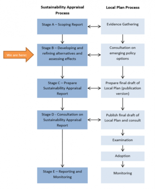 Figure
1‑1: Iterative
SA and Plan-making processes[2]
Figure
1‑1: Iterative
SA and Plan-making processes[2]
Table 1-1: Progress of SA and LPR processes
|
LPR Stage |
Sustainability Appraisal & Strategic Environmental Assessment Stage and requirements |
Completed? |
|
|
Evidence Gathering and Issues and Options |
A. Setting the context and objectives, establishing the baseline and deciding on the scope |
Identify related plans/programmes |
Scoping Report consulted on between 18th August – 30th October 2017 |
|
Identify environmental protection objectives |
|||
|
Baseline data and likely future trends |
|||
|
Identify sustainability issues and opportunities |
|||
|
Develop objectives, indicators and targets (SA Framework) |
|||
|
Prepare SA Scoping Report |
|||
|
Consult on the SA Scoping Report |
|||
|
Review scoping consultation responses and preparation of Final Scoping Report to inform next stage. |
Completed February 2018 |
||
|
Draft LPR Regulation 18 |
B. Developing, refining and appraising alternatives and assessing effects C. Preparing SA Report |
Assess LPR Vision and Objectives against the SA Framework |
Completed by Arcadis in 2018/19 in this Interim SA Report Stage |
|
Assess growth and spatial options and their reasonable alternatives against the SA Framework |
|||
|
Assess preferred policy options, including allocations and their reasonable alternatives |
|||
|
Propose mitigation measures |
|||
|
Propose monitoring programme |
|||
|
Prepare Non-Technical Summary (NTS) |
|||
|
Prepare SA Report |
|||
|
Consult on the SA Report |
|||
|
Publication LPR Regulation 19 |
C. Update and amend SA Report in light of changes to LPR D. Consultation on SA Report |
Identify changes to LPR since previous stage significant changes |
Stage to be completed |
|
Determine relevance of changes to the LPR for the SA/SEA, including assessments of new or revised policies with cumulative and synergistic effects assessment updated accordingly |
|||
|
Update all other elements to the SA Report in light of the changes to the LPR |
|||
|
Ensure the SA Report is compliant with the SEA Directive in terms of requirements for an Environmental Report |
|||
|
Consult on the SA Report |
|||
|
Examination |
C & D. Update and amend report in light of any Modifications to the LPR |
Determine the relevance of any Modifications made to the LPR as an outcome of Examination. |
Stage to be completed |
|
Assess Main Modifications for their likely impacts on SA Framework |
|||
|
Prepare addendum to the SA Report addressing the Main Mods and any new significant impacts on the Framework |
|||
|
Submission Examination and Adoption |
E. Adoption Statement |
Stage to be completed |
|
1.6 Contents of in this document
1.6.1 This document constitutes an Interim SA Report to accompany the LPR Preferred Options consultation. It therefore provides an appraisal of the options presented in the LPR. In addition to this, this Interim SA Report provides an appraisal of the options considered within the Issues and Options LPR document. Overall, this document provides an appraisal of:
- Four growth scenarios (i.e. different quantities of housing and jobs targets) (Issues and Options) assessed in Appendix C;
- Preferred approach: 8,622 homes and 15,580 jobs - A trend-based scenario based on the forecast employment needs of the Borough and the 2018 update to the OAN;
- Alternative Scenario A: 11,420 homes and 19,040 jobs - A trend-based scenario based on the forecast employment needs of the Borough and the 2017 calculated OAN;
- Alternative Scenario B: 25,837 dwellings and 32,376 jobs - An infrastructure-led scenario based on a high increase in growth in Ipswich, with a 40% increase in the 2017-homes target relative to OAN; and
- Alternative Scenario C: 30,143 dwellings and 32,376 jobs - An infrastructure-led scenario based on a high increase in growth in Ipswich, with a 40% increase in the 2017-homes target relative to OAN.
- Six spatial options (i.e. different strategies for the distribution of growth) (Issues and Options) assessed in Appendix C:
- Spatial Option 1: Higher-density urban regeneration;
- Spatial Option 2: Increased development beyond the Borough boundary;
- Spatial Option 3: Changing the use of existing land in the Borough to housing;
Options from Suffolk Coastal District Council
- Spatial Option 4: Continuation of existing approach;
- Spatial Option 5: Focus on Ipswich and A14 transport corridor; and
- Spatial Option 6: A12 transport corridor and dispersed rural focus.
- Strategic Spatial Approach (Core Strategy LPR) Policies assessed in Appendix D:
- ISPA1 Growth in the Ipswich Strategic Planning Area Policy
- ISPA2 Strategic Infrastructure Priorities Policy
- ISPA3 Cross-boundary Mitigation of Effects on Protected Habitats and Species Policy
- ISPA4 Cross-boundary Working to Deliver Sites
- Policy CS1: Sustainable Development - Climate Change
- Policy CS2: The Location and Nature of Development
- Policy CS3: IP-One Area Action Plan
- Policy CS4: Protecting our Assets
- Policy CS5: Improving Accessibility
- Live (Core Strategy LPR) Policies assessed in Appendix D:
- Policy CS7: The Amount of New Housing Required
- Policy CS8: Housing Type and Tenure
- Policy CS10: Ipswich Garden Suburb
- Policy CS11: Gypsy and Traveller Accommodation
- Policy CS12: Affordable Housing
- Work (Core Strategy LPR) Policies assessed in Appendix D:
- Policy CS13: Planning for Jobs Growth
- Policy CS14: Retail Development and Main Town Centre Uses
- Learn (Core Strategy LPR) Policies assessed in Appendix D:
- Policy CS15: Education Provision
- Play (Core Strategy LPR) Policies assessed in Appendix D:
- Policy CS16: Green Infrastructure, Sport and Recreation
- Infrastructure (Core Strategy LPR) Policies assessed in Appendix D:
- Policy CS17: Delivering Infrastructure
- Policy CS18: Strategic Flood Defence
- Policy CS19: Provision of Health Services
- Policy CS20: Key Transport Proposals
- Development Management (Core Strategy LPR) Policies assessed in Appendix D:
- Policy DM1: Sustainable Construction;
- Policy DM2: Decentralised Renewable or Low Carbon Energy;
- Policy DM3: Air Quality;
- Policy DM4: Development and Flood Risk;
- Policy DM5: Protection of Open Spaces, Sports and Recreation;
- Policy DM6: Provision of New Open Spaces, Sports and Recreation Facilities;
- Policy DM7: Provision of Private Outdoor Amenity Space in New and Existing Developments;
- Policy DM8: The Natural Environment;
- Policy DM9: Protection of Trees and Hedgerows;
- Policy DM10: Green Corridors;
- Policy DM11: Countryside;
- Policy DM12: Design and Character;
- Policy DM13: Built Heritage and Conservation
- Policy DM14: Archaeology
- Policy DM15: Tall Buildings
- Policy DM16: Extensions to Dwellings and Provision of Ancillary Buildings
- Policy DM17: Small Scale Infill and Backland Residential Developments
- Policy DM18: Protection of Amenity;
- Policy DM19: The Subdivision of Family Dwellings;
- Policy DM20: Transport and Access in New Developments;
- Policy DM21: Car and Cycle Parking in New Development;
- Policy DM22: The Density of Residential Development;
- Policy DM23: Protection and Provision of Community Facilities;
- Policy DM24: Shopfront Design;
- Policy DM25: Advertisement;
- Policy DM26: The Central Shopping Area;
- Policy DM27: Arts, Culture and Tourism;
- Policy DM28: The Evening and Night-time Economy;
- Policy DM29: District and Local Centres;
- Policy DM30: Town Centre Uses Outside the Central Shopping Area;
- Policy DM31 Retail Proposals Outside Defined Centres;
- Policy DM32: Protection of Employment Land; and
- Policy DM33: Delivery and Expansion of Digital Communications Networks.
- Site (Site Allocation DPD LPR) Policies assessed in Appendix E:
- Policy SP2: Land allocated for housing:
- IP003 Waste tip and employment area north of Sir Alf Ramsey Way
- IP004 Bus depot, Sir Alf Ramsey Way
- IP009 Victoria Nurseries, Westerfield Road
- IP010a Co-op Depot, Felixstowe Road
- IP010b Felixstowe Road
- IP011a Lower Orwell Street (former Gym & Trim and (formerly listed as Smart Street/Foundation Street),
- IP011b Smart Street, Foundation Street (South)
- IP011c Smart Street, Foundation Street (North)
- IP012 Peter's Ice Cream
- IP014 Hope Church
- IP015 West End Road Surface Car Park
- IP028a Island adjacent to Jewsons, Greyfriars Road.
- IP028b Jewsons, Greyfriars Road and island adjacent.
- IP029 Land opposite 674-734 Bramford Road
- IP031 Burrell Road including land to the east with access from Burrell Road.
- IP032 King George V Field, Old Norwich Road
- IP033 Land at Bramford Road (Stocks site)
- IP035 Key Street / Star Lane / Burtons (St Peter Port)
- IP037 Island Site
- IP039a Land between Gower Street & Gt Whip Street
- IP040 Former Civic Centre, Area / Civic Drive (Westgate)
- IP041 Former Police Station, Civic Drive
- IP043 Commercial Buildings and Jewish Burial Ground, Star Lane
- IP045 Land bounded by Cliff Road, Toller Road and Holywells Road
- IP047 Land at Commercial Road
- IP048a Mint Quarter / Cox Lane East regeneration area
- IP048b Mint Quarter / Cox Lane West regeneration area
- IP052 Land between Lower Orwell Street & Star Lane (former Essex Furniture)
- IP054b Land between Old Cattle Market and Star Lane
- IP061 Former School Site, Lavenham Road
- IP064a Land between Holywells Road and Holywells Park
- IP066 JJ Wilson and land to rear at Cavendish Street, White Elm Street
- IP067a Former British Energy Site
- IP080 240 Wherstead Road
- IP083 Banks of River upriver from Princes Street
- IP089 Waterworks Street
- IP096 Car Park Handford Road East
- IP098 Transco, south of Patteson Road
- IP105 Depot, Beaconsfield Road 0.33 15 45dph (DM30b)
- IP119 Land east of West End Road
- IP120 Land west of West End Road
- IP129 BT Depot, Woodbridge Road
- IP132 Former St Peters Warehouse Site, 4 Bridge Street
- IP133 South of Felaw Street
- IP135 112-116 Bramford Road
- IP136 Silo, College Street
- IP143 Former Norsk Hydro, Sandyhill Lane
- IP150d Land south of Ravenswood – Sports Park
- IP150e Land south of Ravenswood
- IP172 15-19 St Margaret's Green
- IP188 Websters Saleyard site, Dock Street
- IP221 Flying Horse PH, 4 Waterford Road
- IP226 Helena Road/Patteson Road
- IP279 Former British Telecom Office, Bibb Way
- IP283 25 Grimwade Street
- IP307 Prince of Wales Drive
- IP346 Suffolk Retail Park
- Policy SP3: Sites awaiting planning permission or a Section 106
- IP005 Former Tooks Bakery, Old Norwich Road 80% residential and c. 20% is safeguarded for the provision of a new health centre.
- IP042 Land between Cliff Quay and Landseer Road
- IP059a & b Arclion House and Elton Park, Hadleigh Road
- IP074 Church and land at Upper Orwell Street
- IP088 79 Cauldwell Hall Road
- IP109 R/O Jupiter Road & Reading Road
- IP116 St Clement's Hospital Grounds
- IP131 Milton Street
- IP142 Land at Duke Street Allocation to provide for public open space (25%).
- IP150a Ravenswood
- IP161 2 Park Road
- IP165 Eastway Business Park, Europa Way
- IP169 23-25 Burrell Road
- IP200 Griffin Wharf, Bath Street
- IP205 Burton's, College Street
- IP206 Cranfields, College Street
- IP211 Regatta Quay, Key Street
- IP214 300 Old Foundry Road
- IP245 12-12a Arcade Street
- IP256 Artificial hockey pitch, Ipswich Sports Club
- Policy SP5: Land allocated for employment use
- IP067b Former British Energy Site
- IP094 Land to rear of Grafton House
- IP140 Land north of Whitton Lane
- IP141a Land at Futura Park, Nacton Road
- IP147 Land between railway junction and Hadleigh Road
- IP150e Land south of Ravenswood
- IP152 Airport Farm Kennels
- IP004 Bus depot Sir Alf Ramsey Way
- IP011b Smart St / Foundation St
- IP043 Commercial Buildings & Jewish Burial Ground Star Lane
- IP051 Old Cattle Market Portman Road
- IP052 Land between Lower Orwell St & Star Lane
- IP132 Former St Peters Warehouse Site, 4 Bridge Street
- Policy SP6: Land allocated and protected as open
- IP029 Land opposite 674734 Bramford Rd
- IP032 King George V Field, Old Norwich Rd
- IP033 Land at Bramford Rd (Stocks Site)
- IP037 Island Site
- IP047 Land at Commercial Road
- IP048 Mint Quarter / Cox lane Regeneration Area
- IP142 Land at Duke Street
- IP061 Former school site Lavenham Road
- Policy SP7: Land allocated for leisure uses or community facilities
- IP005 Former Tooks Bakery, Old Norwich Rd (As part of a residential-led mixed use redevelopment)
- IP010a Co-op Depot, Felixstowe Rd (As part of a residential development)
- IP150b Land at Ravenswood (7.8ha)
- Policy SP8: Orwell Country Park Extension
- Site IP149 Land at Pond Hall Carr and Farm
- Policy SP9: Safeguarding land for transport infrastructure
- IP010a or b Felixstowe Road
- IP059a Land at Elton Park Works
- IP037 Island Site
- IP029 Land opposite 674734 Bramford Road
1.7 How the Preferred Options were arrived at
1.7.1 The Preferred Options set out in the draft Local Plan Review (Regulation 18) have been formulated principally on the basis of providing for objectively assessed needs for housing and other uses within the Borough, as required under paragraph 11 of the NPPF (2018) and the available evidence. The amount of housing required has been based on the standardised methodology in the NPPF (2018), the mix of housing on Part 2 of the Ipswich Strategic Housing Market Area Assessment (SHMA) (2017) and the level of affordable housing on part 2 of the Ipswich SHMA (2017). The question of uplift to the housing figure was considered but rejected, because there are not strategic growth plans adopted across the County, investment in major infrastructure in the form of the Ipswich Northern Routes, which could unlock more growth, is not yet committed, and because of the Borough's limited capacity. Ipswich Borough Council Executive Report E/18/32 'Ipswich Local Plan Review Preferred Options' refers.
1.7.2 Employment needs have been considered on the basis of the Ipswich Economic Area Sector Needs Assessment (2017) and the Ipswich Economic Area Employment Land Supply Assessment (2018). Objectively assessed needs for other uses such as retail provision and gypsy and traveller accommodation have also been used as the starting point for drafting the preferred options. The majority of the evidence used has been reviewed jointly with neighbouring authorities which together form the Ipswich Strategic Planning Area (ISPA). This is to consider cross-boundary needs arising from the tightly drawn administrative boundary around Ipswich.
1.7.3 Beyond the objectively assessed needs, the preferred options have also been arrived at due to the need to incorporate revisions to the NPPF which occurred in July 2018. For example, policy CS12 'Affordable Housing' has been revised to reflect the amended definitions of affordable housing in the NPPF. Other policies have been amended on the basis of monitoring results that the Council has collected. An example of this includes the amendments to the Central Shopping Area policy DM26 to respond to the declining performance of retail uses in the town centre. New policies such as DM28 'The Evening and Night-time Economy' and DM3 'Air Quality' have been introduced in consideration of qualitative and quantitative feedback received from other departments and users within and outside the Council where appropriate.
1.7.4 A review of site allocations contained with the Site Allocations and Policies DPD (2017) has been undertaken on the basis of a comprehensive update to the Strategic Housing and Employment Land Availability Assessment (SHELAA) which is published alongside the Local Plan Review Preferred Options. This update includes the consideration of unimplemented housing and economic allocations, land ownership, land submitted through 'Call for sites' and issues and options consultations during 2017, as well as other considerations. Additions, amendments and removals of housing and economic sites within the Core Strategy and Policies DPD Review and the Site Allocations and Policies DPD Review have been undertaken on the basis of the recent update to the SHELAA.
1.7.5 The SHELAA included the consideration of two remaining areas of greenfield land at the edge of the Borough: land at Humber Doucy Lane in the north east, and land at Whitton Church Lane/Thurleston Lane in the north west. Whilst both areas have constraints, the work on the SHELAA concluded that some of the land in North West Ipswich was not suitable, for example protected allotments, and other land which may be suitable was not available or achievable for development at this time. Sites within the Broad Area at North East Ipswich at the northern end of Humber Doucy Lane were actively promoted through the adopted Local Plan process and the call for sites process in 2017. The broad location for future growth identified at the north end of Humber Doucy Lane is identified to meet future need after 2031. This broad location of future growth will need to be master planned with Suffolk Coastal District Council, with whom there have been positive discussions about the deliverability of necessary infrastructure and would substantially follow on from development at the Ipswich Garden Suburb.
[2] Source of figure: SA Scoping report prepared by the Council