Ipswich Borough Council Local Plan Site Allocations and Policies (incorporating IP-One Area Action Plan) DPD Review - Final Draft
Part E
Appendices
Appendix 1
A Summary of the Tests of Soundness
Development plan documents are subject to independent examination by a planning inspector. The inspector considers whether the plan has been prepared in accordance with the Duty to Cooperate and legal and procedural requirements, and whether it is 'sound'.
Soundness is assessed in terms of whether the plan meets the following tests of soundness, as set out in the National Planning Policy Framework (paragraph 35):
- It should be positively prepared – the plan should be based on a strategy which seeks to meet objectively assessed development and infrastructure requirements, including unmet requirements from neighbouring authorities where it is practical to do so and consistent with achieving sustainable development;
- It should be justified – the plan should be an appropriate strategy, when considered against the reasonable alternatives, based on proportionate evidence;
- It should be effective – the plan should be deliverable over its period and based on effective joint working on cross-boundary strategic matters that have been dealt with rather than deferred as evidenced through a statement of common ground; and
- It should be consistent with national policy – the plan should enable the delivery of sustainable development in accordance with the policies in the Framework.
Appendix 2
A list of Policies Contained in this Document
Chapter 4 Site Allocations
Policy SP1 The protection of allocated sites
Policy SP2 Land allocated for housing
Policy SP3 Land with planning permission or awaiting a Section 106
Policy SP4 Opportunity Sites
Policy SP5 Land allocated for employment use
Policy SP6 Land allocated and protected as open space
Policy SP7 Land allocated for leisure uses or community facilities
Policy SP8 Orwell Country Park Extension
Policy SP9 Safeguarding land for transport infrastructure
Chapter 5 IP-One
Policy SP10 Retail Site Allocation
Policy SP11 The Waterfront
Policy SP12 Education Quarter
Policy SP13 Portman Quarter (formerly called Ipswich Village
Policy SP14 Arts, Culture and Tourism Policy relocated to Part C Chapter 9 of the Core Strategy, as it is primarily a development management policy.
Policy SP15 Improving pedestrian and cycle routes
Policy SP16 Transport Proposals in IP-One
Policy SP17 Town Centre Car Parking
Chapter 6 Opportunity Areas
This chapter sets out urban design and development principles for the seven Opportunity Areas:
A Island Site
B Merchant Quarter
C Mint Quarter and surrounding area
D Education Quarter and surrounding area
E Westgate
F River Corridor and Princes Street Corridor
G Upper Orwell River and Canalside – this is the area in the vicinity of West End Road.
H Holywells
3A Site Allocation Details
This Appendix is attached separately, as the map content results in a large file size.
Please note that development is required to take into account appropriate the constraints identified through the site sheets. Land allocations are made through the policies of the plan.
3B Development constraints for sites identified through policy SP3 where construction is not already underway
|
Site reference |
Address |
Development constraints |
|
IP005 |
Former Tooks Bakery, Old Norwich Road |
Doctor's surgery to be included. Access constraints and possible contamination. The site is close to the Whitton Conservation Area. Any cumulative impacts on the conservation area with the development of adjacent site IP032 and site IP140 will need to be taken into account. Archaeology - the site lies on high ground above the Gipping Valley. The adjacent site IP032 has been subject to geophysical survey and a desk based assessment has been carried out for both sites. There is potential for remains of multiple periods on the site and trenched evaluation will be required. Water infrastructure and/or treatment upgrades will be required to serve the proposed growth, or diversion of assets may be required. This site falls within the 91.4m height consultation zones surrounding Wattisham airfield. A transport assessment and travel plan will be required. Surface water flooding local to site |
|
IP042 |
Land between Cliff Quay and Landseer Road |
Archaeology - no objection in principle to development but it will require a condition relating to archaeological investigation attached to any planning consent. There are listed buildings within the site of planning permission 12/00700/OUT approved 19/12/13, e.g. the listed Brewery site. Flood risk. TPOs on site and adjacent. |
|
IP059b |
Arclion House and Elton Park, Hadleigh Road |
Archaeology - this site is in a topographically favourable location overlooking the River Gipping, in a general area of prehistoric remains (IPS 104, IPS 034). No objection in principle to development but it will require a condition relating to archaeological investigation attached to any planning consent. A desk based assessment would be appropriate in the first instance, to establish impacts of past land use. Need to ensure land is safeguarded to land a pedestrian and cycle bridge to the river path (see Policy SP9). Possible contamination, TPO on site or nearby and adjacent to a flood zone. Need to address drainage issues. This site falls within the 91.4m height consultation zones surrounding Wattisham airfield. A transport assessment and travel plan will be required. |
|
IP074 |
Church and land at Upper Orwell Street |
Archaeology - this site lies in the historic core of the Anglo-Saxon town. No objection in principle to development but it will require a condition relating to archaeological investigation attached to any planning consent. Archaeological costs have the potential to be relatively high Listed building and adjacent to a TPO tree. |
|
IP088 |
79 Cauldwell Hall Road |
No requirement for archaeology. |
|
IP109 |
R/O Jupiter Road & Reading Road |
No requirement for archaeology. |
|
IP116 |
St Clement's Hospital Grounds |
Sports facilities should be retained or replaced. TPOs on site or nearby and adjacent to a local wildlife site (the golf course). Design and layout should support wildlife corridor functions. Bat and reptile surveys will be required prior to any vegetation clearance, and mitigation where appropriate. Archaeology - This development affects an area of high archaeological potential, as defined by information held by the County Historic Environment Record (HER). The proposed works will cause significant ground disturbance that have the potential to damage any archaeological deposits that exist. There is no objection in principle to development but any permission will require a condition relating to archaeological investigation. Historic buildings should be assessed. Water infrastructure and /or treatment upgrades will be required to serve the proposed growth, or diversion of assets may be required. |
|
IP131 |
Milton Street |
Possible contamination. Surface water flooding local to site. |
|
IP142 |
Land at Duke Street |
Close to an Air Quality Management Area, possible contamination, and TPOs on site or nearby (an application for Tree Works may be needed). Surface water flooding local to site - will need to be considered at planning application stage. |
|
IP150a |
Ravenswood S & T (adjacent Fen Bight Circle) |
Archaeology - the site lies in the vicinity of Prehistoric and Medieval sites. No objection in principle to development but it will require a condition relating to archaeological investigation attached to any planning consent. Development should link into cycling and pedestrian route networks. |
|
IP169 |
23-25 Burrell Road |
Archaeology - this site lies on the bank of the Orwell. No objection in principle to development but it will require a condition relating to archaeological investigation attached to any planning consent. Archaeological monitoring of groundworks is likely to be appropriate. Flood risk. |
|
IP200 |
Griffin Wharf, Bath Street |
Archaeology - this is a large site on the edge of the river, close to Medieval sites (IPS 145, IPS 294).No objection in principle to development but it will require a condition relating to archaeological investigation attached to any planning consent. Flood risk. |
|
IP205 |
Burton's, College Street |
Archaeology - this site lies in an area of international archaeological importance, on the Anglo-Saxon and Medieval waterfront of Ipswich (Historic Environment Record IPS 413). This site potentially represents that last surviving section of 'early' waterfront. The site will involve potentially high excavation costs. Measures for archaeology should be addressed at an appropriate stage in the planning process. Early consultation and evaluation is advised so that decisions can be taken on preservation in situ, and/or appropriate investigation strategies designed. Flood risk. |
|
IP206 |
Cranfields, College Street |
Archaeology - this site has been subject to large scale excavation but post-excavation work was stalled by the development situation and there is still an outstanding obligation for assessment, conservation, analysis and publication, particularly of important waterlogged wooden structures from the Anglo-Saxon waterfront. Preservation by record has not been met, and the condition on IP/04/00313 remains outstanding. Any new applications would require a condition or agreement to secure post-excavation work. Any additional proposed groundworks should be subject to consultation. Flood risk. |
|
IP211 |
Regatta Quay, Key Street (subject to further discussions with agent) |
Archaeology - this site has largely been excavated. Applications involving further groundworks should be subject to a condition relating to archaeology, where appropriate. Flood risk. |
|
IP214 |
300 Old Foundry Road |
The site is in the Central Conservation Area and an Air Quality Management. This site lies within the historic core of Ipswich and within the Area of Archaeological Importance (IPS413), close to the town defences. Detailed early pre-application discussions with Suffolk County Council Archaeological Service would be required to agree the scope of required assessment and to inform design. Surface water flooding local to site. |
|
IP245 |
12-12a Arcade Street |
The site is in the Central Conservation Area and next to a listed building. The site is also within the Area of Archaeological Importance (IPS413). Detailed early pre-application discussions with Suffolk County Council Archaeological Service would be required to agree the scope of required assessment and to inform design (e.g. to allow for preservation in-situ of deposits or appropriate programmes of work). Archaeological remains may be complex and important and mitigation could involve significant costs and timescales. Surface water flooding local to site - will need to be considered at planning application stage. There is a Flood Incident Report for this site. |
|
IP256 |
Artificial Hockey Pitch, Ipswich Sports Club |
Development needs to accord with Core Strategy policy DM5. TPO along the eastern boundary. Possible drainage constraint. Surface water flooding local to site - will need to be considered at planning application stage. This site lies in the vicinity of Iron Age and Roman sites. Whilst it remains an area of archaeological potential, given the impacts of previous landscaping there would be no requirement for an archaeological condition or work on this site on the basis that it looks heavily truncated. |
Appendix 4 – Opportunity Areas
(1) Site ref: IP028b Jewsons, Greyfriars Road
Site Area: 0.90ha
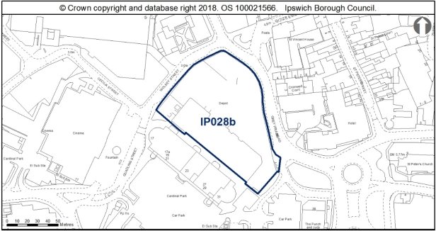
Allocation Policy SP4
|
Use(s) |
Indicative capacity |
|
|
Primary |
Residential |
40 (90dph on 50% of the site) |
|
Secondary |
Leisure (A3/A5, D2) Office (B1a) |
4,000sqm |
* see Core Strategy policy DM23 for minimum and average densities.
Adopted Plan 2017
N/A – new site but was previously considered as part of a larger site UC029 for 20% housing through IP-One Area Action Plan Preferred Options 2007 and again with IP028a at Preferred Options Stage in January 2019.
Current use
Builders' yard.
Development constraints/issues
This site likely lies in the former extent of the town marsh. Palaeo-environmental assessment and mitigation for impacts on deeper deposits may be required. Deep excavations may encounter waterlogged features. Stratigraphy may be expected to be particularly deep in former streams and watercourses, and waterlogged features are recorded in the Urban Archaeological Database.
Adjacent to a scheduled ancient monument.
Water infrastructure and/or treatment upgrades will be required to serve the proposed growth, or diversion of assets may be required.
A transport assessment and travel plan will be required.
Surface water flooding local to site - will need to be considered at planning application stage. See Appendix 1 of the Ipswich SFRA.
Adjacent to site with possible contamination, a contaminated land assessment would be required.
This allocation site is presently used as a builders' yard, with a large warehouse to the southwest of the site, with the land along Greyfriars Rose and Wolsey Street principally used for the outdoor storage of materials.
The site is adjacent to the boundary of the Central Conservation Area, and nearby the Grade II* listed Church of St Nicholas and its heritage assets within the churchyard. Some distance to the south is the prominent Church of St Mary at Stoke, which is elevated above the river valley. St Nicholas and St Mary's churches presently benefit from a degree of intervisibility, which needs careful consideration in planning for the site.
Further north along Franciscan Way is the Grade I Willis building. Depending on design, scale and massing, development of the allocation site also has the potential to affect the significance of the Willis building, with the introduction of built mass to the allocation site likely to be visible in the reflective finish of the Willis building.
As the allocation site backs onto Cardinal Park and the rear of the block of commercial units, the tallest part of the development should seek to screen the utilitarian rears of these buildings from Grey Friars Street with a building of high quality design.
The development of the site should be master planned to ensure that the residential, leisure and office use of the allocation site form a cohesive scheme, with the design and layout of development responding to the varied uses of the site. Redevelopment is dependent on the mitigation of noise from the adjacent nightclub. A contemporary approach to design, would be encouraged, with a contrasting use of scale and form to break up the massing of buildings to provide architectural interest and engaging frontages.
The development of this site should include a high quality, usable public realm, which should encourage users between Cardinal Park, the allocation site and the town centre.
Given the nature of this site, an invasive plant species assessment should be included part of any Preliminary Ecological Assessment to accompany a planning application. To achieve biodiversity net gain, the recommendations of the Ipswich Wildlife Audit 2019 could be incorporated into future development, unless other means of biodiversity enhancement are appropriate.
Site ref: IP045 Land bounded by Cliff Road, Toller Road and Holywells Road
Site area: 2.06ha
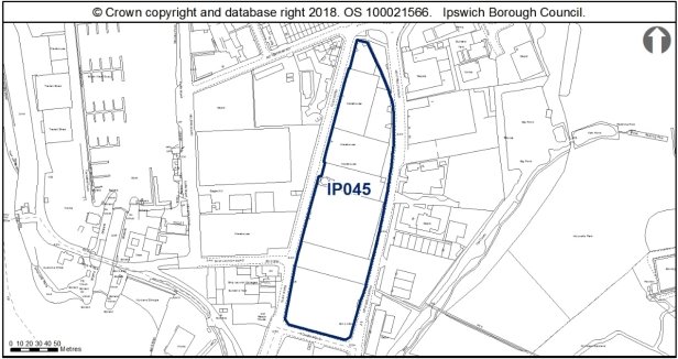
Allocation Policy SP4
|
Use(s) |
Indicative capacity |
|
|
Primary |
Residential |
148 (90dph on 80% of site*) |
|
Secondary |
Employment (B1a uses such as offices) Community, Arts, Culture, Open Space, Tourism |
2,500sqm |
* see Core Strategy policy DM23 for minimum and average densities.
Adopted Plan 2017
N/A new site previously considered under Preferred Options 2007 for 50% residential and 50% employment.
Current use
Employment uses, part of employment area E11.
Development constraints / issues
Existing land uses would need to relocate. Potential contaminated land, contaminated land assessment required.
A transport assessment and travel plan will be required.
Site is located in a flood zone; this will need to be considered at planning application stage. See Appendix 1 of the Ipswich SFRA.
The allocation is within 250m of the access to the safeguarded minerals facility, rather than the facility itself. The relationship with the safeguarded facility would need to be considered as part of the masterplanning and design of development.
This site lies on the edge of the historic channel of the Orwell. There is potential for buried historic deposits. Conditions relating to archaeological work are likely to be relevant on any consent. Desk-based assessment and review of geotechnical data would be appropriate in the first instance.
This allocation site is located between the Wet Dock Conservation Area and Holywells Park Conservation Area and presently in use for industrial uses. The site is wedge shaped and occupies land between Cliff Road and Holywells Road, and is located to the north of the cluster of Grade II listed buildings associated with Cliff Quay Brewery, and is opposite The Ship Launch Inn, which is included on the Local List SPD. This allocation site is therefore in a sensitive historic environment which requires careful attention when developing a proposal for the redevelopment of this site, considering the impact on the introduction of development within the setting of these heritage assets, as well as considering views into and out of adjacent Conservation Areas.
The warehouses which presently occupy the site are not of historic or architectural interest, and the comprehensive redevelopment of this site is encouraged. Recent residential development off Patteson Road is of three and four storey domestic scale which utilises polychrome brick banding and timber weatherboarding which has introduced interesting architectural detailing to the area, which the development of this site should look to respond to. The use of masonry utilising textured and polychromatic brick bonds would in the redevelopment of this allocation site would allow for the site to be distinctive whilst also relating to the existing development to the north.
Development should principally be of domestic scale, reflecting the scale established at Patteson Road, however some taller units to accommodate flats could be incorporated into the site, but they should still respect the overriding domestic scale of architecture. Proposals should ensure that new buildings have active elevations to all four frontages which provide visual interest to the street scene, avoiding repetitive fenestration schemes and external finishes.
The proposed secondary use for the site should respect the architectural principles employed for the residential core of the site, responding positively to the design and appearance of the redevelopment site. This secondary use could be concentrated in a landmark building to provide visual interest and break up the massing of surrounding residential development. It should be noted that a landmark building need not necessarily be tall and/or overscaled. A careful, bespoke design respecting the scale of adjacent residential buildings could still provide a building of distinctive landmark quality.
As this site is located close to Holywells Park CWS and is east of the River Orwell CWS, there is an opportunity to create smallscale steppingstone habitats which will in turn contribute to the wider ecological network. To achieve biodiversity net gain, the recommendations of the Ipswich Wildlife Audit 2019 could be incorporated into future development, unless other means of biodiversity enhancement are appropriate.
The site is in close proximity to the Stour and Orwell SPA/ Ramsar site. Information to inform a project level HRA will be required to demonstrate that urbanisation impacts on the site are prevented.
Site ref: IP052 (UC055) Land between Lower Orwell Street & Star Lane
Site area: 0.40ha
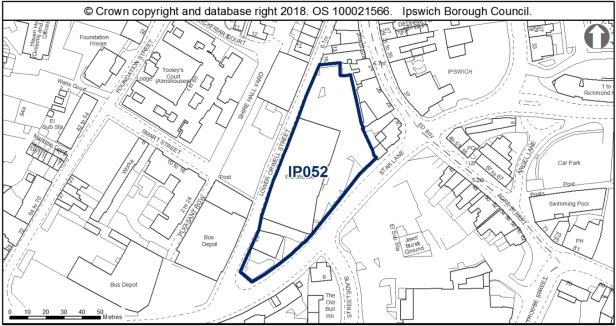
Allocation Policy SP4 & SP5
|
Use(s) |
Indicative capacity |
|
|
Primary |
Residential |
29 (90dph on 80% of site*) |
|
Secondary |
Employment (B1 uses such as offices, research & development, light industrial uses appropriate in a residential area) |
1,000sqm |
* see Core Strategy policy DM23 for minimum and average densities.
Adopted Plan 2017
As above but identified through policy SP3
Current use
Vacant warehouse, gym, hand car wash, temporary car parking.
Development constraints / issues
Within an Air Quality Management Area. The site is adjacent to the Central Conservation Area, scheduled monuments, grade II* 24 Fore Street and grade II 26-28 Fore St.
Listed buildings bound the site to the east along Fore Street, whilst development could also affect the wider setting of nearby heritage assets along Foundation Street, Key Street and the waterfront. This allocation site includes a boundary marker, which is included on the Local List (Buildings of Townscape Interest) SPD. This marker is located on Lower Orwell Street within the rear boundary wall of the central warehouse which occupies the site, however the degree of local listing applies only to the marker, and not the full extent of the wall.
Redevelopment of this allocation site therefore needs to accommodate the locally listed boundary marker. Owing to the historic function of boundary markers to signal the extent of parish boundaries to serve administrative functions, it is important that the boundary marker is located in the same position as existing if the rear wall is to be replaced in the redevelopment of the site.
Development should have regard for the domestic 2-3 storey scale of historic development along Fore Street which backs onto this site, and should ensure to address both Lower Brook Street and Star Lane, providing a landmark element which turns the corner at the junction of these routes. The building line could be set back from Star Lane, or provide a staggered frontage so as not to not create a tunnelling effect, particularly to the south west of the side adjacent to Premier Inn. Development along Lower Orwell Street should look to enliven the street scene, which is currently overshadowed by the trees to the west of the site which are covered by a TPO, and owing to the lack of fenestration along the rear of the allocation site, provide Lower Orwell Street with a particularly dark and unwelcoming character.
Improvements to the public realm should also be incorporated to the development of the allocation site, improving the pedestrian experience of Star Lane and accessing the waterfront from the town centre, and also allowing for pedestrian access through the site east to west.
Possible contamination and part within a flood zone.
Development principles for the Merchant Quarter, within which the site is located, are set out in Chapter 6 of the Site Allocations and Policies plan (see 'Opportunity Area B').
This site is within the urban core and the Area of Archaeological Importance (IPS 413) and close to scheduled areas of Middle Saxon and medieval occupation (NHLE 1005985 and NHLE 1002966). There is a potential for nationally important archaeological remains outside of scheduled areas. Detailed early pre-application discussions with Suffolk County Council Archaeological Service would be required to agree the scope of required assessment and to inform design (e.g. to allow for preservation in-situ of deposits or appropriate programmes of work). Archaeological remains may be complex and important and mitigation could involve significant costs and timescales.
Any opportunity to widen the Star Lane footways through redevelopment would be welcomed, to deliver potential improvements to the visual, pedestrian, cyclist and air quality environment of Star Lane.
(1) Site ref: IP226 Helena Road/Patteson Road
Site area: 1.87ha
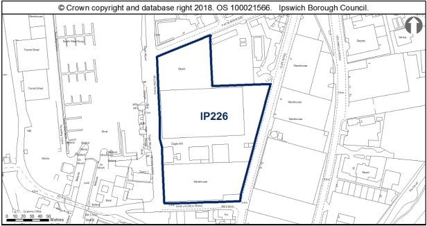
Allocation Policies SP4
|
Use(s) |
Indicative capacity |
|
|
Primary |
Residential |
337 dwellings (200dph on 90% of the site) |
|
Secondary |
Uses compatible with Waterfront Policy SP11 |
|
* see Core Strategy policy DM23 for minimum and average densities.
Adopted Plan 2017
Site was previously safeguarded under SP3 of the plan but has not come forward for development. Previously 540 dwellings at high density.
Current use
Timber storage
Development constraints / issues
Historic planning application for 566 dwellings, which has now expired.
Potential contamination land and a contaminated land assessment is required
Adjacent to a Listed Building and the Wet Dock Conservation Area. The site lies on the edge of the channel of the Orwell. There is potential for buried historic deposits. No objection in principle to development but it will require a condition relating to archaeological investigation attached to any planning consent.
This allocation site is located immediately adjacent to the Wet Dock Conservation Area to the west, occupying a key waterfront position towards the south of the Conservation Area. The Ship Launch Inn is to the immediate south of the allocation site, which is included on the Local List (Buildings of Local Townscape Interest) SPD.
The site is occupied by warehousing to the south, with the northern section being used as a depot. The southernmost building is a large brick warehouse dating from the early 20th century, and does have some architectural interest, with polychromatic masonry, round headed windows, and three prominent gables. This building could be reused in the redevelopment of the site, utilising the existing openings and lantern roof to provide natural light to the development.
The remainder of the site holds little architectural interest, and the replacement of these buildings would be encouraged. Development should address Helena Road which faces towards the waterfront with an interesting, eye catching design which contributes positively to the Wet Dock Conservation Area. Development should encourage pedestrian movement around the waterfront. The western side of the allocation site could accommodate taller development, whilst stepping down to a more domestic scale eastwards.
The design of development should also recognise Cliff Road to the east as a principal elevation and provide an expressive frontage which engages with the street scene to the west. A contemporary design approach would be welcomed, responding to adjacent architectural influences, such as the polychromatic masonry in the southern warehouse, and also to the north at the recent development off Patteson Road.
The site is in close proximity to the Stour and Orwell SPA/ Ramsar site. Information to inform a project level HRA will be required to demonstrate that urbanisation impacts on the site are prevented.
Site sheets
Site ref: IP003 Waste tip and employment area north of Sir Alf Ramsey Way
Site area: 1.41ha
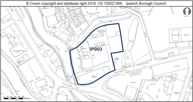
Allocation Policy SP2
|
Use(s) |
Indicative capacity |
|
|
Primary |
Residential |
114 (90dph* on 90% of the site) |
|
Secondary |
Small Scale retail/leisure Offices B1(a) |
200sqm 800sqm |
* see Core Strategy policy DM23 for minimum and average densities
Adopted Plan 2017
N/A – new site but was previously considered for 100% housing through IP-One Area Action Plan Preferred Options 2007.
Current use
Waste recycling centre, concrete batching plant & employment premises
Development constraints/issues
Development principles for the Upper Orwell River and Canalside within which the site is located, are set out in Chapter 6 of the Site Allocations and Policies Plan (See 'Opportunity Area G').
Possible contaminated land, an assessment would be required. The site currently holds an environmental permit which will need to be surrendered when the area is redeveloped. If controlled waste is to be removed, the operator must ensure a registered carrier is used to convey the waste to a suitably permitted facility. All documentation to be kept in accordance with regulations. Further guidance can be found on the Environment Agency's Waste pages.
In terms of archaeology, the Development and Archaeology SPD 2018, states that in this part of the town, the archaeological questions and impacts of development are different from those within the core. There are likely to be deep reclamation deposits. Where major excavations are undertaken, recording may be necessary to record preserved layers and structural remains. Generally, however, geotechnical modelling would be fundamental in the first instance. Palaeoenvironmental modelling may be required to capture information relating to the river before it is destroyed, but deposits are not anticipated to be complex in the urban sense, although there is potential for waterlogged remains. Generally, it would be anticipated that archaeological matters could be dealt with through a condition on consent, depending on details. Questions exist around the character and nature through time of the river, manmade channels, and the marsh.
Parts of the site are covered by facility retention policies of the Suffolk County Council Minerals and Waste Local Plan. Alternative sites will need to be agreed with the County Council and the site operators for the relocation of the Concrete Batching Plant and Household Waste Recycling Centre before the sites can be made available.
Water infrastructure and/or treatment upgrades may be required to serve the proposed growth, or diversion of assets may be required.
Surface water flooding local to site - will need to be considered at planning application stage. See Appendix 1 of the Ipswich SFRA.
Development must take account of the River Corridor Buffer (10m) where no development should take place.
A transport assessment and travel plan will be required.
County Wildlife Site and Local Nature Reserve adjacent to the site. The site may have wildlife interest an ecological, bat and reptile survey will be needed. Development of this site should ensure that the Alderman Canal corridor and its associated habitats are buffered and enhanced. Any future green space should be sited adjacent to the canal, to complement it. The design and layout would need to support the wildlife corridor function. The recommendations of the Ipswich Wildlife Audit 2019 could be incorporated into future development, unless other means of biodiversity enhancement are appropriate. . Footpath 44 (River Path) exists along the site's western and northern edge.
New development on this site should be of high quality and have regard for the context of the site, and thus should address the Alderman Road Recreation Ground, river walk, River Gipping and Sir Alf Ramsey Way, providing active, engaging frontages to all of these outlooks.
Attention is drawn to the Valley Ipswich Urban Characterisation Study SPD adopted in 2015, which states, 'The Alderman Canal is a historic feature which has been managed as natural riverside habitat accessed by wooden walkways. This is an approach which should be developed wherever possible in the Valley character area. A wide range of building types and designs is possible in this setting. The area lacks good visual connectivity to the town centre, however (commercial buildings along Civic Drive have created a wall-like barrier). Master planning for vacant sites in the Portman Road area should take into account the need for a legible new street network which links where possible with the inner urban area'.
Pedestrian access to Cullingham Road could be provided to link London Road and Portman's Walk via a less vehicle dominated route.
Opportunities for soft landscaping within the allocation site should also be explored, as a way of extending the green landscape of Alderman Park into the allocation area once developed.
Site ref: IP004 (UC004) Bus Depot, Sir Alf Ramsey Way
Site area: 1.07ha
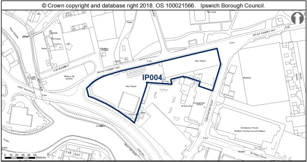
Allocation Policies SP2 & SP5
|
Use(s) |
Indicative capacity |
|
|
Primary |
Residential Offices (B1a) |
48 (90dph on 50% of site*) 5,000sqm |
* see Core Strategy policy DM23 for minimum and average densities
Adopted Plan 2017
48 dwellings at 90dph on 50% of the site
Offices (B1a) 5,000sqm
Current use
Ipswich Buses bus depot
Development constraints / issues
Development principles for the Upper Orwell River and Canalside within which the site is located, are set out in Chapter 6 of the Site Allocations and Policies Plan (See 'Opportunity Area G').
Need to relocate the bus station first.
Development is required to retain the tram shed with the expectation that it would be converted for office use. The tram shed is included on the Local List of buildings of townscape interest.
In terms of archaeology, this site is close to prehistoric remains (IPS 004, 148 and 150). There is no archaeological objection in principle to development but any permission will require a condition relating to archaeological investigation. Historic buildings on the site would require assessment.
Flood risk and possible contamination are further constraints. Surface water flooding local to site - will need to be considered at planning application stage. See Appendix 1 of the Ipswich SFRA.
A transport assessment will be required.
The site is close to uses which are safeguarded through the Suffolk Waste Core Strategy, and is also in close proximity to existing minerals uses.
New development on this site would need to have regard for the heritage asset within the allocation area, the early 20th century bus shed which is included on the Buildings of Local and Townscape Interest SPD. It is expected that the bus shed will be retained and converted as part of the development of this site. A conversion scheme would need to respect the architectural language and detail of the existing building, maintaining the existing openings and respecting the rhythm of the fenestration scheme.
The open bus parking area to the west of the bus depot could accommodate a contemporary 3-4 storey building, using the junction of West End Road/Portman's Walk as the principal design focus to create a landmark building. Development in this location should have an elevation design which would address both West End Road and Portman Walk, acknowledging both roads with principal frontages. Some spacing/stepping down would be required to address the change in scale of the former bus depot to ensure the locally listed bus shed is not dominated by the new development.
(1) Site ref: IP009 (UC009) Victoria Nurseries, Westerfield Road
Site area: 0.39ha
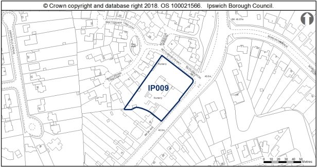
Allocation Policy SP2
|
Use(s) |
Indicative capacity |
|
Residential |
12 (30dph*) |
* see Core Strategy policy DM23 for minimum and average densities.
Adopted Plan 2017
100% housing at low density – 12 dwellings
Current use
Plant nursery and small convenience shop
Development constraints / issues
Possible contamination and a TPO on site or adjacent. Surface water flooding local to site - will need to be considered at planning application stage. See Appendix 1 of the Ipswich SFRA.
This site is close to a known Prehistoric site (IPS 246). There is no objection in principle to development but any permission will require a condition relating to archaeological investigation.
Development of this site would need to address both Westerfield Road and Kettlebaston Way, providing active, engaging elevations to both frontages. A development scheme would need to respect the prevailing domestic scale of surrounding development of detached and pairs of semi-detached dwellinghouses adjacent. Continuation of the established building line of Westerfield Road would be encouraged which would also allow for domestic landscaping to the front of the site, which would contribute to the suburban character of the area, as noted in the Parks Ipswich Urban Characterisation Study, adopted in 2015.
A bespoke approach to design would be encouraged to address the varied architectural character of properties along Westerfield Road as the road transitions from the more historic 19th buildings to the south into the 1930s suburban expansion of the town to the north.
(2) Site ref: IP010a (UC010) Co-Op Depot Felixstowe Road
Site area: 2.22ha
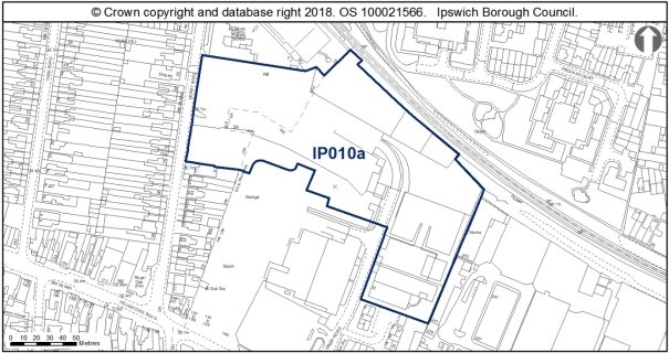
Allocation Policies SP2, SP7 & SP9
|
Use(s) |
Indicative capacity |
|
|
Primary |
Residential |
75 (45dph on 75% of site*) |
|
Secondary |
School extension (approximately 25%) |
0.5ha |
* see Core Strategy policy DM23 for minimum and average densities.
Adopted Plan 2017
As above.
Current use
Vacant or part used yards, and employment premises.
Development constraints / issues
Expansion needed at Rose Hill School.
Possible contamination, TPO on site or nearby, noise from the railway. Design and layout would need to support the wildlife corridor function of the railway. An ecological survey (including flora, reptiles, bats and badgers) will be needed prior to any vegetation clearance and mitigation where appropriate. To achieve biodiversity net gain, the recommendations of the Ipswich Wildlife Audit 2019 could be incorporated into future development, unless other means of biodiversity enhancement are appropriate.
In terms of archaeology, this site lies close to prehistoric and Palaeolithic remains (IPS 056). Depending on the nature of ground works, a condition may be recommended for archaeological works.
A transport assessment and travel plan will be required. Land should be reserved as part of the development of either IP010a or IP010b to facilitate development of a cycle and pedestrian bridge to link the District Centre with the housing to the north of the railway.
This allocation site is accessed off Derby Road and Felixstowe Road and wraps around the north of the Rosehill Centre adjacent to the railway line. The future development of this site should, if feasible, not prohibit the adjacent allocation at IP010b from being accessed from Hines Road.
The proposed extension to Rose Hill Primary School should reflect the distinctive character of the existing school buildings onto Derby Road, a building with origins in the early 20th Century, which experienced remodelling and extensions in the middle of the century. It features various textured brickwork bonding, canted bays with moderne and art deco influences in curved elements and wide windows with a strong horizontal emphasis. The school extension should seek to respond to these architectural influences in the design and appearance of the extension, whilst also being read independently of the existing range to act as a landmark building to signify the gateway to the new development of the allocation site.
The residential development of this allocation site should respect the established grid layout of the Rosehill area, and follow the perimeter block form with active frontages facing the streets, an established characteristic of the area, as identified in the California Urban Characterisation Study SPD. Existing dwellinghouses in California are principally red brick terraces and pairs of semi-detached houses, with often a prevailing architectural feature which characterises a particular road or area, such as the position of the front door, the pattern of fenestration, the use of bay windows, which has led to some distinctive areas of development.
This varied approach to employing architectural details to create pockets of distinguishable housing should be incorporated into the development of the allocation site to ensure the design of the new development is high quality and distinctive.
Parking should be incorporated into the design proposals to encourage the public realm to contribute positively to the character and experience of the development at the allocation site.
Development of the site should consider the enhancement of pedestrian links to the school avoiding main roads in the interests of highway safety.
(1) Site ref: IP010b (UC010) Felixstowe Road
Site area: 2.79ha
Allocation Policy SP2 & SP9
|
Use(s) |
Indicative capacity |
|
|
Primary |
Residential |
62 (45dph* on 50% of site) |
|
Secondary |
Current employment uses (land not available for development) |
- |
* see Core Strategy policy DM23 for minimum and average densities.
Adopted Plan 2017
60% housing at medium density – 75 dwellings
40% Current employment uses
Current use
Various employment uses and multiple occupiers
Development constraints / issues
Redevelopment is dependent on existing uses being relocated.
Possible contamination, TPO on site or nearby, noise from the railway. Design and layout would need to support the wildlife corridor function of the railway. An ecological survey (including flora, reptiles, bats and badgers) will be needed prior to any vegetation clearance and mitigation where appropriate. To achieve biodiversity net gain, the recommendations of the Ipswich Wildlife Audit 2019 could be incorporated into future development, unless other means of biodiversity enhancement are appropriate.
In terms of archaeology, this site lies close to prehistoric and Palaeolithic remains on Foxhall Road (IPS 056). Depending on the nature of ground works, a condition may be recommended for archaeological works, with a desk-based assessment in the first instance.
A transport assessment and travel plan will be required. Land should be reserved as part of the development of either IP010a or IP010b to facilitate development of a cycle and pedestrian bridge to link the District Centre with the housing to the north of the railway.
It is envisaged that residential development is likely to come forward on the eastern and western sides of the site, because there has been no indication from the users in the centre that they may relocate.
The residential development of this allocation site should respect the established grid layout of the Rosehill area, and follow the perimeter block form with active frontages facing the streets, an established characteristic of the area, as identified in the California Urban Characterisation Study SPD. Existing dwellinghouses in California are principally red brick terraces and pairs of semi-detached houses, with often a prevailing architectural feature which characterises a particular road or area, such as the position of the front door, the pattern of fenestration, the use of bay windows, which has led to some distinctive areas of development.
This varied approach to employing architectural details to create pockets of distinguishable housing should be incorporated into the development of the allocation site to ensure the design of the new development is high quality and distinctive.
Parking should be incorporated into the design proposals to encourage the public realm to contribute positively to the character and experience of the development at the allocation site.
Site ref: IP011a (UC011) Lower Orwell Street former Gym & Trim (formerly Smart Street/ Foundation Street)
Site area: 0.15 ha
Allocation Policy SP2
|
Use(s) |
Indicative capacity* |
|
|
Primary |
Residential |
18 (110dph on 100% of site) |
* see Core Strategy policy DM23 for minimum and average densities
Adopted Plan 2017
100% housing at high density – 14 dwellings
Current use
Disused gym building and car park
Development constraints / issues
It is close to an Air Quality Management Area (Star Lane) and just outside the Flood Zone and contains trees protected through a TPO (an application for tree works may be needed).
The site is adjacent to the Central Conservation Area, close to the grade II listed Tooley's Court and Smart's Almshouses, contains a scheduled monument and lies within an area of archaeological importance. This allocation is located within the setting of several listed buildings and locally listed buildings, including the remains of the Blackfriars Priory, numerous historic buildings along Fore Street and the former Smart Street School. The site is therefore highly sensitive with regard to the possible impacts on the historic environment.
Development principles for the Merchant Quarter, within which this site is located, are set out in Chapter 6 of the Site Allocations and Policies plan (see 'Opportunity Area B').
This site affects an area of archaeological importance within the area of the Anglo-Saxon and medieval town. The site lies over the line of the Anglo-Saxon and medieval town defences, and the 14th century Friary wall. Much of the site is a scheduled monument (List entry no: 1005985). Scheduled Monument Consent (SMC) is a legal requirement for any development which might affect a monument either above or below ground level. Historic England administers the SMC application process on behalf of the Secretary of State for Digital, Culture, Media and Sport and should be consulted at the earliest opportunity to discuss the nature of the development. SMC is a separate process from the planning system.
There is a high potential for archaeological remains of national significance and detailed early pre-application discussions with Suffolk County Council Archaeological Service and Historic England would be required. Archaeology may be a major consideration for project costs and timescales. Proposals would need to be supported by programmes of pre-determination archaeological works which may include desk-based assessments, survey works and archaeological evaluation. Complex archaeological mitigation is likely to be required which could include watching briefs, full excavation and / or design scheme changes to allow for preservation in situ. Design questions would relate to the surviving defences and structures in particular, which were largely left in situ in earlier excavations. Post-excavation analysis, assessment and reporting would also be necessary.
Planning permission was granted in 2007 for the erection of 3-4 storey buildings to provide 40 no. residential units on this site. This permission has lapsed, however refreshed policy and guidance with regard to the protection and enhancement of the historic environment has been issued since the 2007 application was approved, including the NPPF, Ipswich Local List (Buildings of Townscape Interest) SPD adopted 2013, Ipswich Development and Archaeology Supplementary Planning Document SPD adopted 2018, Historic England's The Setting of Heritage Assets: Historic Environment Good Practice Advice in Planning Note 3, and Conservation Principles Policies and Guidance.
Therefore, the design, scale, massing, appearance and materials of the proposed building would need careful consideration to ensure that a building on this site does not harm the significance of nearby listed buildings, locally listed buildings, or the Conservation Area, through inappropriate development within the setting of these heritage assets.
The design should have regard for the sensitive historic setting of the application site, whilst taking a contemporary design approach to make a positive design statement which respects the transition between waterfront and town centre.
The site is expected to require improvements to the existing water supply and foul sewerage networks to enable development.
To achieve biodiversity net gain, the recommendations of the Ipswich Wildlife Audit 2019 could be incorporated into future development, unless other means of biodiversity enhancement are appropriate.
(1) Site ref: IP011b (UC011) Smart Street / Foundation Street (South)
Site area: 0.62ha
Allocation Policy SP2
|
Use(s) |
Indicative capacity |
|
|
Primary |
Residential |
56 (90dph) |
* see Core Strategy policy DM23 for minimum and average densities.
Adopted Plan 2017
80% housing at high density – 50 dwellings – on a site which included IP011c to the north.
Current use
First bus depot, and employment works.
Development constraints / issues
Bus depot needs to be relocated before development could commence.
Air quality, flood risk, possible contamination, possible access constraints, TPO on site or nearby (an application for Tree Works may be needed). The site lies between the Central and Wet Dock Conservation Areas, close to the grade II* St Mary at Quay church, contains two scheduled monuments and lies within an area of archaeological importance.
Development principles for the Merchant Quarter, within which the site is located, are set out in Chapter 6 of the Site Allocations and Policies plan (see 'Opportunity Area B'). The site provides important linkage for the redevelopment of Merchant Quarter and would provide improved frontage along Star Lane, which in turn would provide visual enhancement to the Central and Wet Dock Conservation Areas. Where possible, the site layout should allow for improvements to the Star Lane frontage such as footway and cycleway provision or widening, and tree planting.
This site, within the Anglo-Saxon core and the Area of Archaeological Importance (IPS 413), includes two separate scheduled monuments relating to the Middle and Late Saxon town (IPS 211 and 213 List Entry numbers 1005986 and 1005985). Scheduled Monument Consent (SMC) is a legal requirement for any development which might affect a monument either above or below ground level. Historic England administers the SMC application process on behalf of the Secretary of State for Digital, Culture, Media and Sport and should be consulted at the earliest opportunity to discuss the nature of the development. SMC is a separate process from the planning system.
There is also a potential for nationally important archaeological remains outside of the scheduled areas. Detailed early pre-application discussions with Suffolk County Council Archaeological Service and Historic England would be required to agree the scope of required assessment, the principle of development and to inform design (e.g. to allow for preservation in-situ of deposits or appropriate programmes of work). Where development is accepted in principle archaeological remains will be complex, important and mitigation could involve significant costs and timescales.
A transport assessment and travel plan will be required.
Surface water flooding local to site - will need to be considered at planning application stage. See Appendix 1 of the Ipswich SFRA.
Development principles must have regard for the sensitive historic setting of this allocation site, and ensure proposals preserve or enhance the settings of nearby designated heritage assets, including the grade II* St Mary at the Quay Church, Tooley's Almshouses and Central and Wet Dock Conservation Areas.
Reinstating a building line along Star Lane which turns the corner of Foundation Street and Lower Orwell Street would be welcome, with the opportunity for development on this site to have a landmark quality to mark the transition between the waterfront and the town centre. The design of the development would be expected to be of high quality to make a positive architectural statement.
The allocation site wraps around the former Smart Street School, which is included on the Local List (Buildings of Townscape Interest) SPD. Development of the allocation site should use a varied approach to massing and layout to avoid enclosing this locally listed building. Pleasant Row is a particularly narrow lane, the redevelopment of this allocation site should look to move the building line away from the edge of Pleasant Row to allow the former school more breathing space to improve the surroundings in which the building is experienced.
Although this site is currently of low wildlife value, the brick and pantile building could support bats and consequently further surveys are recommended. To achieve biodiversity net gain, the recommendations of the Ipswich Wildlife Audit 2019 could be incorporated into future development, unless other means fo biodiversity enhancement are appropriate.
(2) Site ref: IP011c Smart Street / Foundation Street (North)
Site area: 0.08ha
Allocation Policy SP2
|
Use(s) |
Indicative capacity |
|
|
Primary |
Residential |
7 (90dph) |
* see Core Strategy policy DM23 for minimum and average densities.
Adopted Plan 2017
Previously part of IP011b – Sites have been subdivided to reflect ownerships.
Current use
Car park
Development constraints / issues
Air quality, flood risk, possible contamination, possible access constraints, TPO on site or nearby (an application for Tree Works may be needed). The site lies adjacent to the Central and Wet Dock Conservation Areas, close to the grade II* St Mary at Quay church, contains two scheduled monuments and lies within an area of archaeological importance.
Development principles for the Merchant Quarter, within which the site is located, are set out in Chapter 6 of the Site Allocations and Policies plan (see 'Opportunity Area B'). Where possible, the site layout should allow for improvements to the Star Lane frontage such as footway and cycleway provision or widening, and tree planting.
This site lies within the Anglo-Saxon core and the Area of Archaeological Importance (IPS 413). The adjacent IP011 sites include two separate scheduled monuments relating to the Middle and Late Saxon town (IPS 211 and 213 List Entry numbers 1005986 and 1005985). The allocation was de-scheduled as a monument in 2016 as a large portion of it has been excavated (IPS 212). The excavated area can be considered archaeologically sterile, although it gives an indication of what might survive on the rest of the site.
There is also limited potential for nationally important archaeological remains outside of the scheduled areas. This is because much of the site has already been excavated in the past. Detailed early pre-application discussions with Suffolk County Council Archaeological Service and Historic England would be required to agree the scope of required assessment, the principle of development and to inform design.
Surface water flooding local to site - will need to be considered at planning application stage. See Appendix 1 of the Ipswich SFRA.
Development of this site must have regard for the highly sensitive setting of this allocation site, with particular regard to the setting of the Central Conservation Area, Smart Street School and Tooley's Almshouses. Development proposals should be of a high quality design, respecting the existing 2 storey scale of development along Foundation Street. The scheme should address both Foundation Street and Smart Street with active, engaging frontages. A contemporary design approach in this location would be welcomed, but should ensure that the design of the proposal has regard for the sensitive historic setting of the site, using the adjacent architectural features (such as varied approaches to textures and bonding of brickwork) to influence the appearance of the allocation site.
(1) Site ref: IP012 (UC012) Peter's Ice Cream, Grimwade Street
Site area: 0.32ha
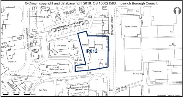
Allocation Policy SP2
|
Use(s) |
Indicative capacity |
|
Residential |
35 (110dph*) |
* see Core Strategy policy DM23 for minimum and average densities.
Adopted Plan 2017
As above
Current use
Former ice cream factory and engineering works.
Development constraints / issues
Planning permission granted for student accommodation subject to a planning agreement (08/00978), however it is considered unlikely to come forward for this use.
Possible access constraints, close to an Air Quality Management Area and there is possible contamination.
This site is within the Anglo-Saxon and medieval core and Area of Archaeological Importance (IPS413). Necessary measures for archaeology should be addressed at an appropriate stage in the planning process. Detailed early pre-application discussions with Suffolk County Council Archaeological Service would be required to agree the scope of required assessment and to inform design (e.g. to allow for preservation in-situ of deposits or appropriate programmes of work). Archaeological remains may be complex and important and mitigation could involve significant costs and timescales.
The site is adjacent to the Central Conservation Area and the grade II* listed St Clement's Church.
Surface water flooding local to site - will need to be considered at planning application stage. See Appendix 1 of the Ipswich SFRA.
Planning permission was granted in 2008 for the erection of a 5-6 storey building to provide in excess of 500 units of student accommodation.
The 2008 scheme was a particularly large scheme given the sensitive historic setting of the site. This permission has lapsed, however refreshed policy and guidance with regard to the protection and enhancement of the historic environment has been issued since the 2007 application was approved, including the 2018 NPPF, Ipswich Local List (Buildings of Townscape Interest) SPD adopted 2013, Ipswich Development and Archaeology Supplementary Planning Document SPD adopted 2018, Historic England's The Setting of Heritage Assets: Historic Environment Good Practice Advice in Planning Note 3, and Conservation Principles Policies and Guidance.
Development of this site should ensure that the design of the proposals address both Star Lane and Grimwade Street, and should look to reinstate an active street scene. The development of this site will inevitably read as the backdrop to the grade II* St Clements Church and thus requires a high quality, bespoke approach to design.
The reuse of the early 20th century brick buildings along Star Lane would be encouraged, as these buildings have group value with Richmond House from the former industrial use of the site as a lawn mower factory at the beginning of the 20th century, and contribute to the setting of this more industrial part of the Conservation Area around the waterfront.
Opportunities should also be taken to improve the public realm around the allocation site, such as widening footpaths along Star Lane, introducing planting and street furniture to Grimwade Street to improve the experience of the area for pedestrians, and create a high quality public realm which would complement the new development at the site.
Although this site is currently of low wildlife value some of the buildings in the could support bats and consequently further surveys are recommended. To achieve biodiversity net gain, the recommendations of the Ipswich Wildlife Audit 2019 could be incorporated into future development, unless other means of biodiversity enhancement are appropriate.
Site ref: IP014 Hope Church, Fore Hamlet
Site area: 0.21ha
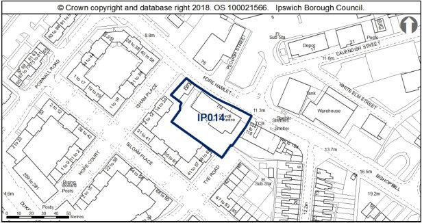
Allocation Policy SP2
|
Use(s) |
Indicative capacity |
|
Residential |
23 (110dph*) |
* see Core Strategy policy DM23 for minimum and average densities.
Adopted Plan 2017
N/A – new site but was previously considered for 100% housing through IP-One Area Action Plan Preferred Options 2007.
Current use
Church with planning permission (18/00316/FUL) to relocate.
Development constraints / issues
Surface water-flooding local to site - will need to be considered at planning application stage. See Appendix 1 of the Ipswich SFRA.
Potential contaminated land. Therefore an assessment would be required.
Within Air Quality Management Area.
This allocation site is occupied by a mid-20th century two storey flat roofed warehouse building located on Fore Hamlet, used as a church, and a 19th century painted brick dwellinghouse, now in commercial use. The site backs onto a modern residential development of three and four storey blocks orientated around landscaped courtyards.
In the 1800s, Fore Hamlet was characterised by residential development, with rows of terraces occupying much of the area between Fore Hamlet and Duke Street, with land gradually being cleared throughout the 20th century to provide expanses of land for industrial activities. The pattern of the fenestration and quoining indicates that the building was formerly two residential units, with the eastern unit being the end of the terrace, and the blank gable of the western elevation suggesting that the building formed part of a longer row of terraces to the west. As this is the last remaining relic of 19th century residential expansion of the town along Fore Hamlet, it is recommended that the retention of the 19th century dwellinghouse should be incorporated into the design proposals for this allocation site. Reinstatement of sash windows and removal of the modern shop front at ground floor would be welcome in this regard.
The development of the remainder of this allocation site should look to take architectural cues from the adjacent development to the south, taking a modern, contemporary design approach. The scale and massing of the proposed development should address the change in topography as Fore Hamlet transitions into Bishop Hill, and step down from the adjacent 5 storey building at 116-144 Fore Hamlet.
The layout of the scheme should mimic the existing development to 'complete' the courtyard block of Isham Place and Siloam Place and include details for the soft landscaping of the courtyard.
Although this site is currently of low wildlife value the buildings in the site could support bats and consequently further surveys are recommended. To achieve biodiversity net gain, the recommendations of the Ipswich Wildlife Audit 2019 could be incorporated into future development, unless other means of biodiversity enhancement are appropriate.
Site ref: IP015 (UC015) West End Road Surface Car Park
Site area: 1.22ha
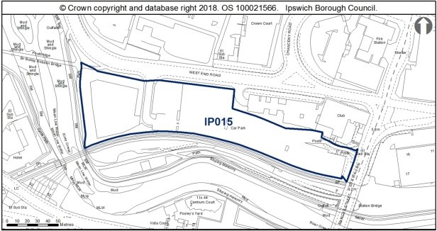
Allocation Policies SP2 & SP17
|
Use(s) |
Indicative capacity |
|
|
Primary |
Long stay car park |
Multi storey car park |
|
Secondary |
Residential |
67 (100dph on 55% of the site) |
* see Core Strategy policy DM23 for minimum and average densities.
Adopted Plan 2017
20% Housing at high density – 22 dwellings
Long stay car park
Offices – 1000sqm
Current use
Surface level long stay car parking.
Development constraints / issues
Existing car parking needs to be replaced on site and potentially accommodate that from Portman Road (IP051) also. The site should be master planned with the adjacent site to the south, fronting the river (IP083). Flood risk, possible contamination and adjacent to a listed building. Development principles for the River Corridor and Princes Street Corridor, within which the site is located, are set out in Chapter 6 of the Site Allocations and Policies plan (see 'Opportunity Area F').
In terms of archaeology, depending on the nature of any ground works, a condition may be attached to any grant of permission relating to archaeological investigation.
The site is close to a County Wildlife Site (the River). Prior to any vegetation clearance, a reptile survey should be undertaken in the western section of the site, with particular attention paid to the vegetated banks. Footpath 61 (River Path) is recorded along the western edge of the site.
Development must take account of the River Corridor Buffer (10m) where no development should take place.
This allocation site is in a strategic position as a gateway site to people entering the town from the south, and in particular arriving from the train station. The development of this site therefore needs to be to a high quality design and make a positive architectural statement adjacent to an important entrance to the town.
The north east corner adjacent to the site is the grade II listed Princes Street Maltings, now being converted into office use. The Maltings is a prominent red brick 19th century building with a long two storey range, decorative Dutch gable to Princes Street, with the tall pyramidal slate roof of the kiln projecting proudly above the main range. The building is thus highly visible in the street scape, with key views of the building being along Burrell Road, Princes Street bridge, Commercial Road, West End Road and indeed further afield owing to the prominent nature of the kiln.
This allocation site is currently a surface car park which allows for long ranging views of the grade II listed maltings across the site, although is of low aesthetic quality, and the redevelopment of this site is welcome. However given the existing undeveloped character of the allocation site, the introduction of development to this car park does have the potential to harm the significance of The Maltings through the introduction of development within the setting of the listed building. The design, massing, scale and layout of the proposed development therefore requires particularly careful consideration to respect the sensitive historic context of the allocation site.
The nature of the scale, massing, design and appearance a multi-storey car park is a key consideration regarding this allocation, with multi storey car parks typically being a single volume building, with the potential to be a particularly tall building. Owing to the massing of multi storey car parks, this building thus has the potential to be extremely prominent, and depending on its proximity to the listed building and position in key views, the car park therefore could be harmful to the significance on the grade II listed maltings, which the Council has a legal duty to protect. This highlights the importance of preserving this key heritage asset when designing proposals for a multi-storey car park.
The secondary land use allocation for this site is to provide 43 residential units. Residential as a development in this location has far greater flexibility in the design, scale and massing than with the single volume multi-storey car park. The layout of the residential units could be laid out in a way to offer key views of The Maltings, with the more human scale of domestic architecture contrasting against the dominating height of the kiln. A well designed residential development in this area therefore has the potential to enhance the significance of The Maltings to provide positive contrast in scale to reveal the prominence of the kiln.
The design of the residential accommodation should have active and engaging frontages to West End Road and views across the river, whilst also create a positive architectural statement which will act as a landmark development signalling the entrance to Ipswich. A contemporary design approach would be encouraged, continuing the varied architectural expressions and use of modern materials around the Portman Quarter and Sir Bobby Robson Bridge to positively contrast the industrial architecture of The Maltings.
Site ref: IP029 (UC030) Land Opposite 674-734 Bramford Road
Site area: 2.26ha
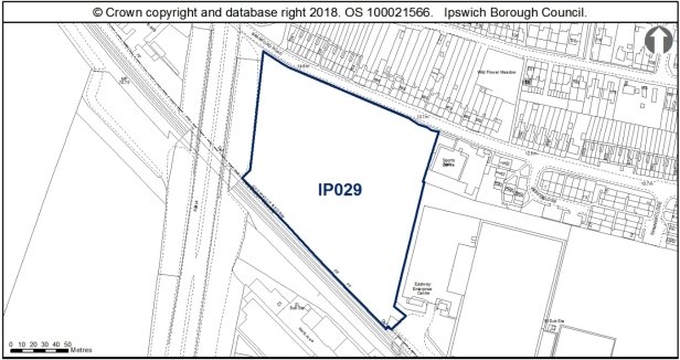
Allocation Policies SP5, SP6 & SP9
|
Use(s) |
Indicative capacity |
|
|
Primary |
Employment |
45% of site (Circa 1ha) |
|
Secondary |
Amenity green space (on 55% of site) |
1.26ha |
* see Core Strategy policy DM23 for minimum and average densities.
Adopted Plan 2017
70% Housing at medium density – 71 dwellings
Current use
Vacant land used informally for recreation. Part recently used in connection with rail chord works.
Development constraints / issues
Loss of informal open space, although it was not identified as recreational open space in the Open Space, Sport and Recreation Study 2009 or the 1997 Ipswich Local Plan. Access constraints, possible contamination, noise from the A14 and railway.
The site has potential wildlife interest Design and layout would need to support the wildlife corridor function of the railway and A14. This site is of at least a medium biodiversity value and detailed surveys could reveal that it has higher ecological significance. Prior to any vegetation clearance, further surveys should continue/be undertaken to assess the wildlife interest, particularly botanical, reptiles, bats, badgers and breeding birds and mitigation implemented as appropriate. Consideration should also be given to the likely impact of vegetation clearance upon the local hedgehog population. New development should retain as much of the existing habitat as possible and integrate it within a landscaping scheme, in particular the hedgerows along the boundaries. The recommendations of the Ipswich Wildlife Audit 2019 could be incorporated into future development, unless other means of biodiversity enhancement are appropriate.
The site offers the potential to provide a link road between Bramford Road and Europa Way. The impacts of such a link are currently being investigated by the Highway Authority. Should the site come forward for development in advance of the outcome being known, the layout should not prejudice the provision of the road. Bridleway 12 is recorded along the site's western edge. Bridleway links are required at the route's northern end to a) connect to the urban footpath leading to Morgan Drive; and b) eastwards to link to Bramford Lane.
Potential Noise from the railway and road network therefore design and layout will need to address this.
In terms of archaeology, this site lies in the vicinity of Roman (IPS 242, IPS 233) and Prehistoric (IPS 018) sites. No objection in principle to development but any permission will require a condition relating to archaeological investigation.
This site falls within the 91.4m height consultation zones surrounding Wattisham airfield, therefore any proposed structures which may exceed this height would need to be reviewed by the Ministry of Defence.
A transport assessment and travel plan will be required.
Opposite the allocation site are rows of interwar terraced housing which feature mansard roofs, with shared dormers and chimneys which penetrate the elongated roof slopes. To the east of the site is a hall used as a place of worship. The hall is a fairly utilitarian structure, however features a prominent, steeply pitched entrance porch which contrasts the shallow pitch of the main range.
A contemporary approach to design utilising distinctive roofs forms would be encouraged, with development proposals taking design cues from adjacent architecture, particularly with regard to the unusual and contrasting roof forms which characterise this western end of Bramford Road.
The layout of the proposal should reflect the existing grain of development of linear streets and grids of housing, and should address the retained amenity space as well as Bramford Road.
Soft landscaping and screening could be installed along the southern and eastern boundary to screen this industrial development and enhance the amenity and biodiversity value of the retained open space.
Site ref: IP031a (UC032) Car Park, Burrell Road
Site area: 0.44ha
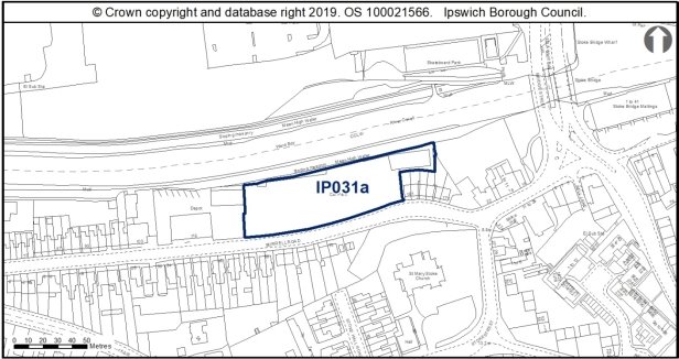
Allocation Policy SP2
|
Use(s) |
Indicative capacity |
|
Residential |
20 (45dph*) |
* see Core Strategy policy DM23 for minimum and average densities.
Adopted Plan 2017
100% housing at medium density – 20 dwellings – on a reduced site.
Current use
Car park, rough ground, roadside landscaping.
Development constraints / issues
In a flood zone, close to an AQMA and possible contamination (former petrol station and car workshop). Development would need to support the wildlife corridor function of the river which is a County Wildlife Site at this point.
This site is within the Area of Archaeological Importance (IPS 413). Desk-based Assessment and consideration of geotechnical data would be advised in the first instance. Depending on proposed groundworks, conditions on consent informing these assessments may be appropriate, to inform archaeological investigation and mitigation, including palaeo-environmental investigation. This site lies along the bank of the Orwell, adjacent to the Stoke Conservation Area and the grade I listed Church of St Mary at Stoke.
Stoke Conservation Area covers the historic core of Stoke from when the area was a modest hamlet before the widespread expansion of the area in the 19th century. Development of this allocation site should therefore have regard to the domestic scale of existing architecture within the Stoke Conservation Area, and should take its architectural influences in terms of height, massing and design from the hamlet of Stoke, rather than seeking to continue the more industrial scale of development found to the north east along the waterfront.
Development must take account of the River Corridor Buffer (10m) where no development should take place.
Development proposals need to address the change in topography to the north of the site as land drops away towards the river to avoid the need to build up site levels which would increase the prominence of buildings on the site, and in turn, affect views into and out of the Conservation Area.
Site ref: IP031b (UC032) 22 Stoke Street
Site area: 0.18ha
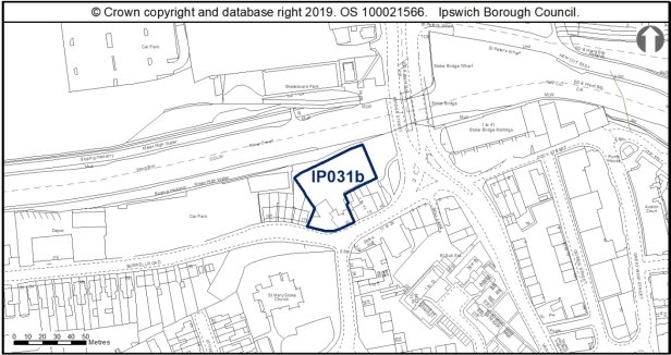
Allocation Policy SP2
|
Use(s) |
Indicative capacity |
|
Residential |
18 (100dph(reflective of highly accessible location – not higher because of heritage constraints.) |
DM23Adopted Plan 2017
100% housing at medium density – 20 dwellings – on a reduced site.
Current use
Car park, rough ground, roadside landscaping.
Development constraints / issues
In a flood zone, close to an AQMA and possible contamination (former petrol station and car workshop). Development would need to support the wildlife corridor function of the river which is a County Wildlife Site at this point. A reptile survey should be undertaken and mitigation for this group undertaken as required. This site is located adjacent to the River Orwell wildlife corridor. Any lighting scheme should be designed to prevent light spillage into this area, or the scrub habitat along the river banks. The recommendations of the Ipswich Wildlife Audit 2019 could be incorporated into future development, unless other means of biodiversity enhancement are appropriate.
This site is within the Area of Archaeological Importance (IPS 413). Desk-based Assessment and consideration of geotechnical data would be advised in the first instance. Depending on proposed groundworks, conditions on consent informing these assessments may be appropriate, to inform archaeological investigation and mitigation, including palaeo-environmental investigation. This site lies along the bank of the Orwell, adjacent to the Stoke Conservation Area and the grade I listed Church of St Mary at Stoke.
Stoke Conservation Area covers the historic core of Stoke from when the area was a modest hamlet before the widespread expansion of the area in the 19th century. Development of this allocation site should therefore have regard to the domestic scale of existing architecture within the Stoke Conservation Area, and should take its architectural influences in terms of height, massing and design from the hamlet of Stoke, rather than seeking to continue the more industrial scale of development found to the north east along the waterfront.
The allocation site would be prominently positioned adjacent to Stoke Bridge, and would thus be visible in views into and out of the Stoke Conservation Area, and also views out of the Central and Wet Dock Conservation Areas and thus in a highly visible location.
The design of a development scheme for this site should therefore have active frontages which address the river to the north, and both Bridge Street and Burrell Road to ensure that new development engages with existing architecture and enhances the street scene when viewed from the many vantage points from where the site can be seen.
The very eastern section of the allocation site is presently open space, which provides pleasant views of the prominent Stoke Hall when approaching Stoke Conservation Area from Stoke Bridge. Stoke Hall is a particularly decorative building, and so development across the existing open space should be carried out sensitively to prevent obscuring views into the Stoke Conservation Area, particularly with regard to Stoke Hall.
Development proposals need to address the change in topography to the north of the site as land drops away towards the river, to avoid the need to build up site levels which would increase the prominence of buildings on the site, and in turn, affect views into and out of the Conservation Area.
Particular thought needs to be given to the development of the eastern parcel of development which wraps around existing 19th century buildings along Burrell Road. A bespoke design approach is required to prevent the new development from reading as awkward backland development, and needs to integrate well with existing buildings on Burrell Road.
Development must take account of the River Corridor Buffer (10m) where no development should take place.
(2) Site ref: IP032 (UC033) King George V Field, Old Norwich Road
Site area: 3.7ha
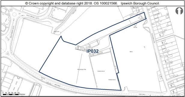
Allocation Policies SP2 & SP6
|
Use(s) |
Indicative capacity |
|
|
Primary |
Residential |
99 (35dph on 80% of site*) |
|
Secondary |
Amenity green space (on 20% of site) |
0.71ha |
* see Core Strategy policy DM23 for minimum and average densities.
Adopted Plan 2017
As above
Current use
Playing fields
Development constraints / issues
Need prior provision of a replacement pitch and ancillary facilities such as changing rooms and spectator accommodation of equivalent or better quality and quantity in the locality and subject to equivalent or better accessibility and management arrangements. Currently there is planning permission in place for replacement pitches and changing facilities to be provided within Mid Suffolk District (reference 0254/13) north of Whitton Sports Centre. However more (80%) of the site can now be redeveloped than previously thought (50%) because the open space to the north of the site is being retained.
Possible contamination. Trees on southern boundary protected by a TPO. Footpath 32 is recorded to the west of, but outside, the site. The development should support the diversion of FP32 off the football pitches and fund an upgrade of the route to bridleway or restricted bridleway status to provide for cycling connectivity to Fisk's Lane (Restricted Byway 75).
In terms of archaeology, the site lies on high ground above the Gipping Valley. It has been subject to geophysical survey, and a desk based assessment has been carried out for both this site and the adjacent site IP005. There is potential for remains of multiple periods on the site and trenched evaluation will be required. There is no objection in principle to development but any permission will require a condition relating to archaeological investigation.
The site is close to the Whitton Conservation Area. The Core Strategy and the published development brief for this site and the adjacent IP005 Tooks Bakery require the Conservation Area to be taken into account. Any cumulative impacts on the conservation area with the development of adjacent site IP005 and site IP140 will need to be taken into account.
In respect of water supply and waste water treatment, infrastructure and / or treatment upgrades will be required to serve the proposed growth, or diversion of assets may be required.
The Council has published a development brief for this site and the adjacent former Tooks bakery site (reference IP005).
Whitton includes numerous listed buildings along Old Norwich Road, and also benefits from Conservation Area designation. To the north of Whitton is the borough boundary, as fields open up to the neighbouring authority of rural Mid Suffolk.
Planning permission has recently been granted at the adjacent Tooks Bakery Site IP0005, which includes an access to this allocation site through the proposed residential development.
The design of the residential development at the allocation site should respond to the architectural approach taken at the Tooks Bakery allocation site IP0005, producing contemporary units utilising textured brick bonds and asymmetric use of cladding to add visual interest and contrast to the scheme.
Whilst acoustic mitigation measures may be required along Bury Road, a continuous timber fence or boundary wall has the potential to deaden the street scene, and would prevent the development site making a positive architectural statement when first entering the borough. This boundary should therefore be well detailed, perhaps utilising a textured brick bond to integrate with the new development, and include soft landscaping at the periphery of the site.
This site falls within the 91.4m height consultation zones surrounding Wattisham airfield, therefore any proposed structures which may exceed this height would need to be reviewed by the Ministry of Defence.
A transport assessment and travel plan will be required. The traffic impact of access from Bury Road will need to be considered. The Old Norwich Road junction has received Section 106 money via a recent appeal to fund a mitigation scheme. Further contributions may be required to mitigate the impact from this site.
Surface water flooding local to site - will need to be considered at planning application stage. See Appendix 1 of the Ipswich SFRA.
Due to the presence of rough grassland around the margins a reptile survey should be carried out prior to any removal of vegetation. New development should retain as much of the higher value existing habitat as possible, for example the hedgerows, and integrate it within a landscaping scheme, to deliver locally accessible natural greenspace. The recommendations of the Ipswich Wildlife Audit 2019 could be incorporated into future development, unless other means of biodiversity enhancement are appropriate.
Site ref: IP033 (UC034) Land at Bramford Road (Stocks site)
Site area: 2.03ha
Allocation Policies SP2 & SP6
|
Use(s) |
Indicative capacity |
|
|
Primary |
Residential Amenity green space (on 50% of site) |
55 (55dph on 50% of site*) 1.02ha |
* see Core Strategy policy DM23 for minimum and average densities.
Adopted Local Plan 2017
As above.
Current use
Open land (fenced).
Development constraints / issues
Possible access constraints, possible contamination (former landfill) to the south of the site which should form the public open space area with the housing element forming the northern area, local wildlife site. There are substantial changes in level which will need to be addressed and the design should ensure that there are links from the site to the existing footpath links bounding the site. An ecological (including breeding birds, great crested newt, bats and badgers) and reptile survey will be needed prior to any vegetation clearance and mitigation where appropriate. Development should retain a thick, scrubby buffer around the pond. To achieve biodiversity net gain, the recommendations of the Ipswich Wildlife Audit 2019 could be incorporated into future development, unless other means of biodiversity enhancement are appropriate.
In terms of archaeology, there were gravel pits across part of the site. Bronze Age and Neolithic finds were recovered (IP018), and Saxon remains were recorded to the south (IPS 499). Evaluation is needed to identify the impact of past land use. There are Saxon sites between this one and the river (IPS 395). There is no objection in principle to development but any permission will require a condition relating to archaeological investigation attached to any planning consent. Early evaluation is advisable.
This site falls within the 91.4m height consultation zones surrounding Wattisham airfield, therefore any proposed structures which may exceed this height would need to be reviewed by the Ministry of Defence.
A transport assessment and travel plan will be required. Access visibility and junction spacing along Bramford Road will need to be considered.
Surface water flooding local to site - will need to be considered at planning application stage. See Appendix 1 of the Ipswich SFRA.
This allocation site is a former gravel and sand pit, now vacant and covered by vegetation. The allocation site is a wedge shaped piece of land, enclosed by residential development on its three main boundaries. The surrounding residential development is varied, with houses along Sproughton Road to the south being earliest, principally dating from the 1930s, the development off Dandalan Close to the east dating from the 1970s, and housing to the west being more recent off Jovian Way.
The allocation site is thus bounded by varied 20th century approaches to domestic architecture, although the existing access off Jovian Way would appear to be the principal access to the site, and so a design which would relate to the more contemporary development would probably be most appropriate, but perhaps with a more distinctive appearance than the development off Jovian Way.
Proposals should look to provide active and engaging frontages onto Bramford Road and Jovian Way, with a layout and design bespoke to the shape of the site.
(2) Site ref: IP035 (UC036) Key Street / Star Lane / Burtons (St Peter's Port)
Site area: 0.54ha
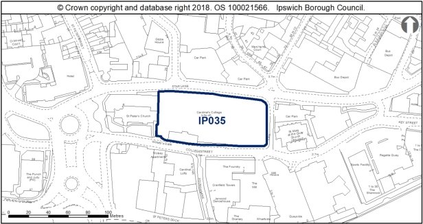
Allocation Policy SP2
|
Use(s) |
Indicative capacity |
|
|
Primary |
Residential |
86 (200dph on 80% of site) |
|
Secondary |
Office, Leisure or Retail (small scale) |
Some individual units up to 200sqm – subject to Core Strategy policy DM32 |
* see Core Strategy policy DM23 for minimum and average densities.
Adopted Plan 2017
Allocation under SP5 for Employment (B1 uses such as offices/Hotel/Leisure/Small scale Retail and car parking) – 2000sqm
Current use
Vacant land apart from the grade II listed 1-5 College Street on south side.
Development constraints / issues
Access constraints, within an Air Quality Management Area, possible contamination, in a flood zone and listed buildings on or adjacent to the site. The site contains the grade II listed 1-5 College Street, adjoins the grade 1 listed and scheduled monument of Wolsey's Gate and lies within an area of archaeological importance. It is located between two conservation areas (Central and Wet Dock) and two grade II* listed churches (St Peter's and St Mary at the Quay).
Development principles for the Merchant Quarter, within which this site is located, are set out in Chapter 6 of the Site Allocations and Policies plan (see 'Opportunity Area B').
This site, the former Cardinal Works, is one of the most important remaining sites in Ipswich with the potential to address major research questions about the origin and development of the town. The site lies on the remains of St Peter's Priory, within the historic core of Ipswich and close to the Anglo-Saxon and medieval waterfront. Evidence for the Priory and preceding Anglo-Saxon occupation was revealed during evaluation (IPS 455). There is high potential for archaeological remains of possible national significance, such as important waterlogged remains and evidence of the later Wolsey's College, and a Quaker burial ground.
Detailed early pre-application discussions with Suffolk County Council Archaeological Service and Historic England would be required in order to agree the scope of required assessment, the principle of development and to inform designs (e.g. to allow for preservation in-situ of deposits or appropriate programmes of work). Where appropriate to development impacts, total archaeological excavation of any development footprint prior to development will be required. Where development is accepted in principle, archaeological remains will be complex and important, and mitigation could involve significant costs and timescales.
This very sensitive site forms part of the transition area from the town centre to the waterfront where development needs to reflect this transition in terms of design and scale etc. Wolsey's Gate is a scheduled monument (List Entry No. 1006071). Proposals impacting upon its setting would require detailed pre-application discussions. The site presents opportunities for enhancing the setting of this scheduled monument. Scheduled Monument Consent (SMC) is a legal requirement for any development which might affect a monument either above or below ground level. Historic England administers the SMC application process on behalf of the Secretary of State for Digital, Culture, Media and Sport and should be consulted at the earliest opportunity to discuss the nature of the development. SMC is a separate process from the planning system.
Development proposals should look to find a long term use for 1-5 College Street, which has been on the borough's Buildings at Risk Register since 1995. If development is approved on the wider site, a Section 106 Agreement would be expected to require the repairs to 1-5 College Street to facilitate a use.
Proposed development around 1-5 College Street should look to enhance the setting of the listed building and the surroundings in which the building is enjoyed, and should not sit in the shadow of new, over scaled development.
More generally, the scheme should look to introduce active frontages to all four of its boundaries to provide an engaging scheme which contributes to the street scene. A contemporary design approach would be welcomed, to positively contrast the historic buildings on and around the allocation site. Development should look to retain intervisibility between St Mary at the Quay and St Peters Churches, whose settings and relationship with one another are important contributors to the significance of these grade II* listed buildings.
Owing to the strategic importance of the site, development should look to improve public access through the site and encourage pedestrian movement across Star Lane and College Street, between the town centre and waterfront. This should also incorporate an area to the north of Wolsey's Gate for formal landscaping to improve access to this nationally important heritage asset.
Further detailed bat surveys will be required on the building as well as potentially detailed invertebrate surveys. The recommendations of the Ipswich Wildlife Audit 2019 could be incorporated into future development, unless other means of biodiversity enhancement are appropriate.
(2) Site ref: IP037 (UC038) Island Site
Site area: 6.02ha
Allocation Policies SP2, SP6, SP15 & SP16
|
Use(s) |
Indicative capacity |
|
|
Primary |
Residential |
421 (100dph on 70% of site*) |
|
Secondary |
Amenity green space (minimum of 15%) Employment and leisure relating to Ipswich Haven Marina (as existing and additional as may be proposed) and enterprise zone. Restaurant and small retail (as existing) Early years education. |
0.90ha |
* see Core Strategy policy DM23 for minimum and average densities.
Adopted Plan 2017
50% Housing at high density – 271 dwellings. Open Space at 0.90ha.
Current use
Mix of uses – boat building, fitting and servicing, pub/restaurant, industrial uses.
Development constraints / issues
Redevelopment will be dependent on the intentions of existing businesses. The aim would be to retain and incorporate the existing boat-related uses and leisure uses. Development would require the provision of additional vehicular and pedestrian/cycle access (see Policy SP9), designed to be in keeping with the Conservation Area, including the provision of access for emergency vehicles as a priority. Any additional access would need to be risk assessed. RB36 and BY38/RB38 (New Cut West) are recorded on either site of the Island. Part of the Island Site now has Enterprise Zone status.
It is close to an AQMA, is in flood zones 2 and 3, and close to the Orwell Estuary Special Protection Area. The site is in close proximity to the Stour and Orwell SPA/ Ramsar site. Information to inform a project level HRA will be required to demonstrate that urbanisation impacts on the site are prevented.. The recommendations of the Ipswich Wildlife Audit 2019 could be incorporated into future development, unless other means of biodiversity enhancement are appropriate.
Development principles for the Island Site are set out in Chapter 6 of the Site Allocations and Policies plan (see 'Opportunity Area A'). They include, for example, retaining and refurbishing historic structures such as the local keeper's cottages and harbour master's house. The site will need to be master planned given its importance, and the master plan will need to address the development principles set out in the plan.
This site is within the Area of Archaeological Importance (IPS 413). There may be archaeological issues in relation to industrial heritage. Historic buildings should be assessed. Detailed early pre-application discussions with Suffolk County Council Archaeological Service would be required to agree the scope of required assessment. The Island site and channel were partly reclaimed from marsh. Previous assessment has shown that the island comprises up to 4.8m of made ground that either seals intact river deposits or lies directly onto river terrace gravels where the channel was previously dredged. Generally, these depths are too deep for conventional mitigation and generally sensitive remains will stay well protected, but historic and waterlogged deposits may survive, including remains of boats and structures. The Island area has palaeo-environmental potential. Made ground includes residual material from other parts of Ipswich.
Development of this site should be of a scale, massing and design which respects the character and appearance of the Wet Dock Conservation Area, and avoid creating a visual barrier which could cut off the buildings to the west of the waterfront to those on the east.
The masterplan should consider 'zones' for the various uses proposed at the allocation site, perhaps focussing the employment uses to the south of the site, and residential development to the north. The amenity space could be located around the Harbour Master's House and Lock Keepers Cottages to enhance the settings of these buildings, possibly utilising these buildings for a public use. A high quality public realm should complement the development of this allocation site, and look for opportunities to reinstate the promenade which once occupied the south of the island with a tree lined pedestrian boulevard.
The site forms a large part of the Wet Dock Conservation Area.
In respect of water supply and waste water treatment, infrastructure and / or treatment upgrades will be required to serve the proposed growth, or diversion of assets may be required.
The scale of residential development expected at the Island site would be sufficient to require early years provision. Its location would need to accord with the Council's Flood Risk and Development SPD.
A transport assessment and travel plan will be required. Traffic impact especially on Bridge Street will need to be considered.
The site is close to uses which are safeguarded through the Suffolk Minerals Core Strategy. The relationship with the safeguarded minerals facility (within 250m) would need to be considered as part of the masterplanning and design.
Potential contaminated land. Therefore an assessment would be required. Potential for indirect impacts from water contamination, particularly during construction.
Development in this location should seek to enable greater recreational, leisure and sports use of the River Gipping and River Orwell, for example though the provision of Upper River Orwell (tidal) slipway or pontoon access and facilities including boat storage facilities, where practicable. Development must take account of the River Corridor Buffer (10m) where no development should take place, wherever practicable.
Site ref: IP039a (UC040 part) Land between Gower Street & Great Whip Street
Site area: 0.48ha
Allocation Policy SP2
|
Use(s) |
Indicative capacity |
|
Residential |
45 (95dph*) |
* see Core Strategy policy DM23 for minimum and average densities.
Adopted Plan 2017
As above
Current use
Part vacant industrial buildings.
Development constraints / issues
In a flood zone, close to an Air Quality Management Area, and possible contamination. Development principles for the Island Site Opportunity Area, within which the site is located, are set out in Chapter 6 of the Site Allocations and Policies plan (see 'Opportunity Area A').
The site is immediately adjacent to a large area of Anglo-Saxon and Medieval occupation at Stoke Quay core (IPS 683) and the Area of Archaeological Importance (IPS 413). There is high potential for Middle Saxon archaeology. Detailed early pre-application discussions with Suffolk County Council Archaeological Service would be required to agree the scope of required assessment and to inform design (e.g. to allow for preservation in-situ of deposits or appropriate programmes of work). Archaeological remains may be complex and important and mitigation could involve significant costs and timescales.
This allocation site is located near to the waterfront to the south of the town centre, adjacent to both the Stoke and Wet Dock Conservation Areas, and is found immediately south of the grade II listed Stoke Bridge Maltings. The allocation site is currently occupied by utilitarian warehousing and bounded by metal security fencing. The site therefore makes little contribution to the street scene, nor setting of adjacent Conservation Areas.
Stoke was once a small hamlet independent of Ipswich, occupied by only a few buildings. The area around Stoke has been developed throughout the 19th century as the town grew and prospered, yet the area to the west is principally a domestic scale. Development to the east is more modern, and reflects the more industrial scale of maltings which once occupied the site. The allocation site is visible in key views out of the Stoke Conservation Area towards the waterfront, and indeed from the Wet Dock Conservation Area towards Stoke. The development of this allocation site therefore needs to respect the transition between the more built up character of the quay to the east, and more human, domestic scale of architecture to the east. Development should therefore balance the provision of housing units without being of a scale which would cause harm to the surrounding historic environment.
Development should look to adopt a contemporary architectural approach, and address all four of its boundaries with active and engaging frontages, utilising varied materials and pattern of fenestration to provide visual interest, whilst breaking up the massing of proposed development.
Surface water flooding local to site - will need to be considered at planning application stage. See Appendix 1 of the Ipswich SFRA.
To achieve biodiversity net gain, the recommendations of the Ipswich Wildlife Audit 2019 could be incorporated into future development, unless other means of biodiversity enhancement are appropriate.
Site ref: IP040 (UC041) Former Civic Centre, Civic Drive (Westgate)
Site area: 0.73ha
Allocation Policies SP2 & SP10 – IP040
|
Use(s) |
Indicative capacity |
|
|
Primary |
Residential |
59 (90dph on 90% of site) |
|
Secondary |
Retail A1 Restaurant (A3) and Theatre-related uses |
2,050 sq m (10%) |
* see Core Strategy policy DM23 for minimum and average densities.
Adopted Local Plan
Allocated with IP041 and existing housing to the south for retail-led mixed use.
10-15,000sqm Retail
20% housing at 100dph – 32 dwellings
Current use
Vacant development site, former Civic Centre, currently used as temporary car park.
Development constraints / issues
All the previous non-residential uses have now been relocated from this site. There is possible contamination. Residential use could be located above or adjacent to retail uses. The residential element of the development should be designed and located so as not to be adversely affected by noise from the Wolsey Theatre.
The site is adjacent to the Central Conservation Area and the Burlington Road Conservation Area lies a little further away to the west. grade II* St Matthews Church also lies to the west. Development principles for Westgate Opportunity Area, within which the site is located, are set out in Chapter 6 of the Site Allocations and Policies plan (see 'Opportunity Area E').
Development on this site should seek to introduce development which addresses Chapman Lane to improve this street scene. Improvements to the public realm along Chapman Lane should also be incorporated to make this a more useable and welcoming street, which is currently dominated by the rears of the 20th century buildings along St Matthews Street. Development along Chapman Lane would also be visible from Westgate Street through Lady Lane, a now much shortened passageway but historically significant as a site of pilgrimage to the shrine of Our Lady of Grace. The views towards the allocation site through Lady Lane should seek to make a positive architectural statement and encourage pedestrian passage along Lady Lane.
The allocation site includes an increase in level to the north of the site. The design of development needs to address this change in topography, in order to prevent the development to the north of the site becoming too dominant, or overshadowing that to the south.
Development should also seek to respond to the remaining pattern of development along Black Horse Lane and reinstate a continuous frontage to the east of the site, the scale of which should respond positively to the existing housing along Black Horse Lane.
The allocation site wraps around the edge of the Spiral Car Park to the west, which has a more contemporary character than the eastern boundary. A contemporary design approach which responds to the curve of the adjacent Spiral Car Park and improves the public realm around the site would be encouraged.
This site is within the Anglo-Saxon and medieval core and the Area of Archaeological Importance (IPS 413). Detailed early pre-application discussions with Suffolk County Council Archaeological Service would be required to agree the scope of required assessment and to inform design (e.g. to allow for preservation in-situ of deposits or appropriate programmes of work). Archaeological remains may be complex and important and mitigation could involve significant costs and timescales.
A transport assessment and travel plan will be required.
Surface water flooding local to site - will need to be considered at planning application stage. See Appendix 1 of the Ipswich SFRA.
The recommendations of the Ipswich Wildlife Audit 2019 could be incorporated into future development, unless other means of biodiversity enhancement are appropriate.
Site ref: IP041 (UC042) Former Police Station, Civic Drive
Site area: 0.52ha
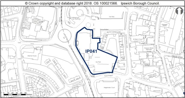
Allocation Policy SP2
|
Use(s) |
Indicative capacity |
|
|
Primary |
Residential |
58 (110dph) |
* see Core Strategy policy DM23 for minimum and average densities.
Adopted Plan 2017
Allocated with IP040 and adjacent housing to the east for retail-led mixed use.
10-15,000sqm Retail
20% housing at 100dph – 32 dwellings
Current use
Vacant site currently used as temporary car park, former county court.
Development constraints / issues
All the previous non-residential uses have now been relocated from this site. There is possible contamination. Residential development should be designed so as not to be adversely affected by noise from the Wolsey Theatre.
The site is adjacent to the Central Conservation Area and the Burlington Road Conservation Area lies a little further away to the west. grade II* St Matthews Church also lies to the west. Development principles for Westgate Opportunity Area, within which the site is located, are set out in Chapter 6 of the Site Allocations and Policies plan (see 'Opportunity Area E').
The existing building on site has interesting architectural aspects, including the glazed entrance and is illustrative of approaches to civic architecture in the mid 20th century. In this regard, the former County Court is important to the more recent history of the town, illustrating the perception of civic improvements to towns and cities in the 1960s and 70s, focusing on car users and providing new municipal centres. Civic Drive illustrates the road widening associated with this movement, whilst the former court represents the architectural approach to civic building at this time. This building could be reused and converted into residential use to provide some of the housing capacity suggested at this site, enhancing the building's architectural features.
The southern part of the site was occupied by the former Suffolk Constabulary Offices, now demolished. Development along Elm Street should therefore look to reinstate a building line to the south, although set back so that development would not harm views into the Central Conservation Area of St Mary at the Elms Church.
Improvements to the public realm which bound the site should also be incorporated into the development of this allocation site, to enhance the surroundings in which this area can be experienced, and indeed enhance the entrance to the Central Conservation Area and historic town centre to the east.
This site is within the Anglo-Saxon and medieval core and the Area of Archaeological Importance (IPS 413). Detailed early pre-application discussions with Suffolk County Council Archaeological Service would be required to agree the scope of required assessment and to inform design (e.g. to allow for preservation in-situ of deposits or appropriate programmes of work). Archaeological remains may be complex and important and mitigation could involve significant costs and timescales.
A transport assessment and travel plan will be required.
Surface water flooding local to site - will need to be considered at planning application stage. See Appendix 1 of the Ipswich SFRA.
The recommendations of the Ipswich Wildlife Audit 2019 could be incorporated into future development, unless other means of biodiversity enhancement are appropriate.
Site ref: IP043 (UC044) Commercial Buildings, Star Lane
Site area: 0.70ha
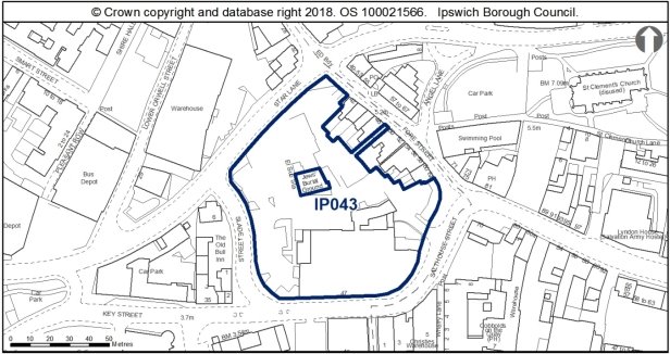
Allocation Policies SP2 & SP5
|
Use(s) |
Indicative capacity |
|
|
Primary |
Residential |
50 (90dph on 80% of site*) |
|
Secondary |
Employment (B1 uses such as offices, research & development, light industrial uses appropriate in a residential area) |
1,000sqm |
* see Core Strategy policy DM23 for minimum and average densities.
Adopted Plan 2017
As above
Current use
Vacant site, Jewish Burial Ground
Development constraints / issues
Access constraints, within an Air Quality Management Area and a flood risk area.
This site is located partly within the Central Conservation Area; it contains grade II listed buildings and adjoins others, including the grade II* 54-58 Fore Street to the north-east, the grade II* Old Custom House to the south-west and the complex of highly graded buildings at Isaac Lord to the south-east. The site lies within an area of archaeological importance. The site presents opportunities for enhancing the setting of the Jewish burial ground which needs to be carefully respected by any development proposal. Any development proposal needs to ensure that adequate arrangements to access the Jewish Burial Ground are retained.
It is considered unlikely to come forward for student accommodation as per an extant permission for the site (11/00267/FUL), hence its inclusion in policy. Development principles for the Merchant Quarter, within which the site is located, are set out in Chapter 6 of the Site Allocations and Policies plan (see 'Opportunity Area B').
This allocation site is therefore in a highly sensitive historic setting, includes numerous heritage assets, and falls within the setting of a high volume of listed buildings. Development on this site therefore requires careful consideration to avoid causing harm to the historic environment through the introduction of development within their setting, whilst also considering the present intervisibility between heritage assets, key views of listed buildings into and out of the Conservation Area.
The development approved under IP/11/00267/FUL for a student village at this site has lapsed. However, refreshed policy and guidance with regard to the protection and enhancement of the historic environment has been issued since the 2011 application was approved, including the 2018 NPPF, Ipswich Development and Archaeology Supplementary Planning Document SPD adopted 2018, Historic England's The Setting of Heritage Assets: Historic Environment Good Practice Advice in Planning Note 3.
Owing to the highly sensitive historic environment which this allocation site has the potential to affect, a bespoke, master planned scheme should be prepared for this site so that the heritage constraints can be positively enhanced and/or preserved by the development of this site.
Development should retain the 1930s building along Key Street/Salthouse Street, possibly utilising this for the secondary employment use.
New development should look to establish building lines along Slade Street and Star Lane, providing active frontages to enhance these routes. The scale of new development should respect the human scale of historic buildings along Fore Street, taking a contemporary approach to design, whilst using the influences of adjacent architecture to respond to the historic context of the allocation site.
Public access through the site to improve permeability and pedestrian routes between the town centre and waterfront should also be provided. This should also include a landscaped courtyard in the centre of the site around the listed walls of the Jewish burial ground to provide a setting in which the listed walls can be experienced, possibly incorporating some heritage interpretation and/or public art relevant to the Jewish history of Ipswich.
This site is within the urban core and area of archaeological importance (IPS 413) and previous archaeological evaluation and limited excavation has revealed Anglo-Saxon and Medieval remains in particular (IPS 639, 371,372, 358). There is outstanding post-excavation work under IP/11/00267) and further work would be needed across the site. There is potential for archaeological remains of possible national significance. Detailed early pre-application discussions with Suffolk County Council Archaeological Service and Historic England would be required in order to agree the scope of required assessment, the principle of development and to inform design. Where development is accepted in principle, archaeological remains will be complex and important, and mitigation could involve significant costs and timescales.
A transport assessment and travel plan will be required.
Surface water flooding local to site - will need to be considered at planning application stage. See Appendix 1 of the Ipswich SFRA.
Although this site is currently of low wildlife value, the older buildings could support bats and
consequently further surveys are recommended. To achieve biodiversity net gain, the recommendations of the Ipswich Wildlife Audit 2019 could be incorporated into future development, unless other means of biodiversity enhancement are appropriate.
Site Ref: IP047 Land at Commercial Road
Site area: 3.11ha
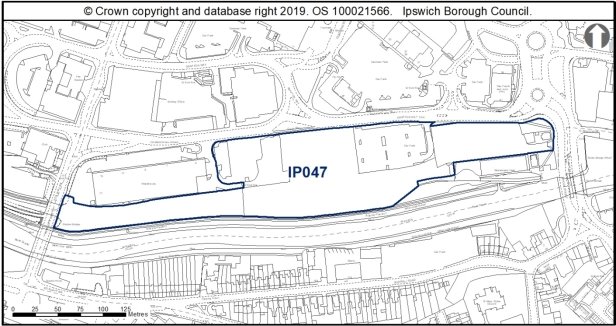
Allocated Policies SP2 & SP6
|
Use(s) |
Indicative capacity |
|
|
Primary |
Residential |
173 (55dph on 80% of site based on pending application 19/00148/OUT) |
|
Secondary |
Hotel/ Leisure/ Retail Public open space and enhanced river path on the southern boundary |
Min 15% of the site to form public open space and enhanced river path – 0.5ha |
Adopted Plan 2017
As above
Current use
Temporary car park, vacant land
Development constraints/issues
Adjacent to Area of Archaeological Importance.
Previous planning permissions (e.g. 08/00953/FUL) have had a condition attached requiring archaeological investigation, which could include archaeological monitoring and recording of initial groundworks with contingency for fuller archaeological recording if deemed necessary; recording the remaining railway features; checking whether any trace of the dock tramway survives; and a palaeoenvironmental sampling strategy.
In a Flood Zone and adjacent to an AQMA. Possible contamination.
Contains trees protected by a TPO (an application for tree works may be required).
Adjacent to the river which forms a continuous green corridor and ecological network and is a County Wildlife Site. Public open space provision should be sited on the southern boundary to enhance the existing wildlife corridor. A survey for reptiles is recommended prior to any vegetation clearance and if present they should ideally be retained within existing habitat on site, or on enhanced habitat adjacent to the site. The recommendations of the Ipswich Wildlife Audit 2019 could be incorporated into future development, unless other means of biodiversity enhancement are appropriate.
FP61 (River Path) is recorded abutting most of the southern edge of the site. The developer should ensure there are high-quality cycle and pedestrian links through the site which help connect the Princes Street Bridge area to the Waterfront area.
Development principles for the River and Princes Street Corridor, within which this site is located, are set out in Chapter 6 of the Site Allocations and Policies plan (see 'Opportunity Area F').
A transport assessment will be needed for this site due to its scale, location and the proposed uses, and it may identify the need to contribute towards significant off-site highway mitigation, depending on the detail of the scheme.
The site is expected to require improvements to the existing water supply and foul sewerage networks to enable development.
Development in this location should seek to enable greater recreational, leisure and sports use of the River Gipping and River Orwell, for example though the provision of Upper River Orwell (tidal) slipway or pontoon access and facilities including boat storage facilities, where practicable.
Development must take account of the River Corridor Buffer (10m) where no development should take place, whereever practicable.
(2)
Site ref: IP048a (UC051) Mint Quarter / Cox Lane East Regeneration Area
Site area: 1.33ha
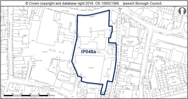
Allocation Policies SP2, SP6, SP7 & SP17
|
Use(s) |
Indicative capacity |
|
|
Primary |
Primary School Amenity green space & short stay multi-storey car parking 40% |
- |
|
Secondary |
Residential 40% |
53 (100dph on 40% of the site) |
* see Core Strategy policy DM23 for minimum and average densities.
Adopted Plan 2017
60% Residential – 72 dwellings
Amenity green space & short stay multi-storey car parking 40%
Current use
Surface level short stay car parking, vacant shops
Development constraints / issues
Short stay parking for shoppers needed and the provision of public open space within the site, however part of these could span Cox Lane into the west part of the site also. A development brief for the whole site (east and west of Cox Lane) will be prepared but development may come forward incrementally.
The identification of the north part of this site for a primary school has replaced the adopted Local Plan allocation IP258 as part of the Education Quarter.
Close to an Air Quality Management Area, possible contamination and TPOs on site or nearby (an application for tree works may be needed). The façade to Carr Street is locally listed. The site lies within an area of archaeological importance, contains a large scheduled monument and is adjacent to the Central Conservation Area, two grade II listed churches (Christ Church and St Pancras) and other listed buildings to the south.
Development principles for the Mint Quarter / Cox Lane regeneration area, within which the site is located, are set out in Chapter 6 of the Site Allocations and Policies development plan document (see 'Opportunity Area C'). FP89 and FP241 are recorded along the western edge of site IP048a. Opportunities should be explored to see if a north-south cycling link can be provided between Carr Street and Tacket Street.
Much of this site is surface level car park which does not contribute to the appearance or general amenity of the area, nor does it encourage pedestrian footfall through the site. The sensitive development of this is therefore welcomed, and has the potential to enhance the setting of the Conservation Area. However as above, the site does fall within the setting of numerous listed buildings, with the surface level car parks reading as open space and so the introduction of development on this allocation has the potential to harm the historic environment, if not designed carefully and with regard to the surrounding heritage.
The buildings along Carr Street are heritage assets included on the Local List SPD, and should be retained and incorporated into development proposals if feasible. These buildings form an important gateway to the town centre, represent the growth and prominence of the Co-operative movement in Ipswich, as well as illustrate early 20th century architectural approaches to commercial development, being formed of four distinctive phases and designs. The removal of the heavy fascia across the front of these buildings would be encouraged, as would the sensitive replacement of the late 20th ground floor shop fronts.
The redevelopment of the site should look to improve views along Cox Lane and create a more welcoming pedestrian route from north to south. Removing the stepped pedestrian footbridge which overhangs Cox Lane between 46 and 48 Cox Lane would assist with this, as would a reduction in the scale of the footbridge between the later phases of the buildings, to open up views to the south. The mosaic to Cox Lane should be retained, or reused in the redevelopment of the site, if it can be removed without causing damage.
Proposals should look to establish a legible layout which will encourage pedestrian access though the site, continuing Cox Lane through the site to reinstate this historic route. Development principles should also look to provide active building frontages which engage with Upper Orwell Street and Tacket Street. The scale of development should respect the existing scale of commercial and residential buildings around the allocation site, perhaps taking a stepped approach to address the transition from town centre to periphery shopping areas of lower scale.
Development should look to reinstate the building line along Upper Orwell Street, respecting the existing scale of development. The existing terrace at 22-28 Upper Orwell Street should be retained and incorporated into the development of the site, taking opportunities to reinstate timber windows and provide shop fronts more sympathetic to the age and character of these buildings.
The site lies within the area of archaeological importance (IPS 413) and much of it lies within a scheduled monument relating to the Middle and Late Saxon town, preserved under current car parks (List entry No 1005983). Scheduled Monument Consent (SMC) is a legal requirement for any development which might affect a monument either above or below ground level. Historic England administers the SMC application process on behalf of the Secretary of State for Digital, Culture, Media and Sport and should be consulted at the earliest opportunity to discuss the nature of the development. SMC is a separate process from the planning system.
There is also potential for nationally important archaeological remains outside the scheduled areas. Detailed early pre-application discussions with Suffolk County Council Archaeological Service and Historic England would be required in order to agree the principle of development and inform designs (e.g. to allow for preservation in-situ of deposits or appropriate programmes of work). Excavations and interventions have taken place in parts of the site and revealed evidence for occupation and activity from the Middle Saxon period onwards - the rest of the site is undisturbed from modern development under car parks and is anticipated to contain rich and well preserved archaeological remains. Development would require full assessment prior to the granting of consent to any proposals - desk based assessment, building survey and field evaluation. Where development is accepted in principle, archaeological remains will be complex and important, and mitigation could involve significant costs and timescales.
A transport assessment and travel plan will be required.
Surface water flooding local to site - will need to be considered at planning application stage. See Appendix 1 of the Ipswich SFRA.
To achieve biodiversity net gain, the recommendations of the Ipswich Wildlife Audit 2019 could be incorporated into future development, unless other means of biodiversity enhancement are appropriate.
Site ref: IP048b Mint Quarter / Cox Lane West Regeneration Area
Site area: 1.34ha
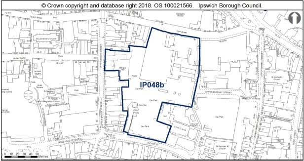
Allocation Policies SP2, SP6, SP10 & SP17
|
Use(s) |
Indicative capacity |
|
|
Primary |
Retail Short Stay Car Park Open Space |
4,800sqm |
|
Secondary |
Residential |
36 (90dph on 30% of the site)* |
* see Core Strategy policy DM23 for minimum and average densities.
Adopted Plan 2017
Secondary Shopping Frontage Zone within the Central Shopping Area.
Current use
Surface level short stay car parking, vacant and occupied shops
Development constraints / issues
Short stay parking for shoppers needed and the provision of public open space within the site, however part of these could span Cox Lane into the east part of the site also. A development brief for the whole site (east and west of Cox Lane) will be prepared but development may come forward incrementally.
Close to an Air Quality Management Area, possible contamination and TPOs on site or nearby (an application for tree works may be needed). The site lies within an area of archaeological importance, contains a large scheduled monument and is adjacent to the Central Conservation Area, two grade II listed churches (Christ Church and St Pancras) and other listed buildings to the south.
Development principles for the Mint Quarter / Cox Lane regeneration area, within which the site is located, are set out in Chapter 6 of the Site Allocations and Policies development plan document (see 'Opportunity Area C'). FP89 and FP241 are recorded along the western edge of site IP048a. Opportunities should be explored to see if a north-south cycling link can be provided between Carr Street and Tacket Street.
Development should look to improve pedestrian permeability through the site, providing a north/south route through the site, whilst also enhancing the pedestrian thoroughfare from Upper Brook Street. In this regard, development should look to provide active and engaging frontages to the pedestrian routes across the site, addressing existing development whilst also being contemporary in appearance, with thoughtful design influenced by the setting of the allocation site.
Proposals should look to respect the scale of existing development of 2-3 storey development along Upper Brook Street and Tacket Street, with the possibility of increasing the scale of development towards the centre of the site around the existing late C20th Co-op building. If the late C20th Co-op building is proposed for retention, then improvements to the external appearance of this building should be included in the redevelopment scheme.
The open space should be incorporated into development proposals, and should look to improve the setting of Christ Church and its associated hall and vicarage. The design of this space could be informed by the archaeological excavations which would be required prior to the development of this site, perhaps including interpretation and/or public art to illustrate the archaeological significance of the area.
The site lies within the area of archaeological importance (IPS 413) and much of it lies within a scheduled monument relating to the Middle and Late Saxon town, preserved under current car parks (List entry No 1005983). Scheduled Monument Consent (SMC) is a legal requirement for any development which might affect a monument either above or below ground level. Historic England administers the SMC application process on behalf of the Secretary of State for Digital, Culture, Media and Sport and should be consulted at the earliest opportunity to discuss the nature of the development. SMC is a separate process from the planning system.
There is also potential for nationally important archaeological remains outside the scheduled areas. Detailed early pre-application discussions with Suffolk County Council Archaeological Service and Historic England would be required in order to agree the principle of development and inform designs (e.g. to allow for preservation in-situ of deposits or appropriate programmes of work). Excavations and interventions have taken place in parts of the site and revealed evidence for occupation and activity from the Middle Saxon period onwards - the rest of the site is undisturbed from modern development under car parks and is anticipated to contain rich and well preserved archaeological remains. Development would require full assessment prior to the granting of consent to any proposals - desk based assessment, building survey and field evaluation. Where development is accepted in principle, archaeological remains will be complex and important, and mitigation could involve significant costs and timescales.
A transport assessment and travel plan will be required.
Surface water flooding local to site - will need to be considered at planning application stage. See Appendix 1 of the Ipswich SFRA.
To achieve biodiversity net gain, the recommendations of the Ipswich Wildlife Audit 2019 could be incorporated into future development, unless other means of biodiversity enhancement are appropriate.
Site ref: IP049 (UC052) No. 8 Shed, Orwell Quay
Site area: 0.76ha
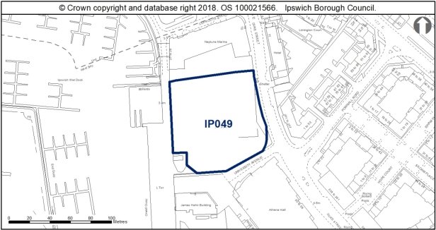
Allocation Policy SP12 and SP17
|
Use(s) |
Indicative capacity |
|
|
Primary |
Education / Waterfront uses Public long stay car parking |
- - |
|
Secondary |
Ancillary uses to university (e.g. GP surgery) |
- |
Adopted Plan 2017
As above
Current use
Temporary surface level long stay car parking.
Development constraints / issues
Within a flood zone, close to an Air Quality Management Area and there may be contamination. It is adjacent to the Wet Dock Conservation Area. RB36 is recorded along the site's western boundary.
Although not located within the Conservation Area boundary, the site does contribute to the setting of the Conservation Area, with views of the waterfront across the site being obtained from Dock Street. Development of this site therefore has the potential to affect the character and special interest of the Wet Dock Conservation Area, and therefore requires careful consideration.
Development should look to make a positive, bold architectural statement, continuing the contemporary design influences of the nearby University of Suffolk building, to create an interesting, intriguing, landmark building which would draw pedestrian movement around the waterfront.
The development of this site should look to respect the existing scale of development, with taller building elements onto the Waterfront, and then stepping down towards Duke Street. Elevations should be sure to address Neptune Quay, University Avenue and Duke Street, providing active frontages which engage positively with the street scene. The public realm surrounding the allocation site should be high quality and encourage pedestrian movement between the waterfront and Duke Street.
A multi-storey car park in this location could be acceptable, however would need to be of a high quality design, finished with quality materials so that the structure is a feature building which contributes positively to the character of the area, and of a height which would not dominate the scale of existing development.
The site is within the Area of Archaeological Importance (IPS413). This site has potential for evidence relating to exploitation of the foreshore from the Middle Saxon period onwards, as well as potential for remains relating to medieval and post-medieval shipyards. Buildings on the site should be assessed. Detailed early pre-application discussions with Suffolk County Council Archaeological Service would be required to agree the scope of required assessment and to ensure that archaeological mitigation can be factored in to project designs.
Development must take account of the River Corridor Buffer (10m) where no development should take place, whereever practicable.
Site ref: IP051 (UC054) Old Cattle Market, Portman Road - South
Site area: 2.21ha
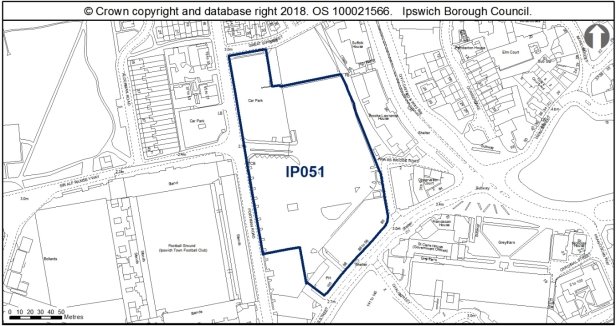
Allocation Policy SP5 & SP17
|
Use(s) |
Indicative capacity |
|
|
Primary |
Offices (B1a) |
20,000sqm |
|
Secondary |
Hotel / Leisure (and possible long stay car parking) |
- |
* see Core Strategy policy DM23 for minimum and average densities.
Adopted Local Plan
As above.
Current use
Surface level long stay car parking, vacant former car showroom, vehicle repair workshop.
Development constraints / issues
There may be a need to provide replacement car parking on site before the site can be redeveloped and/or this may be accommodated at the site on West End Road (IP015). Possible contamination and in a flood zone. Development principles for River Corridor and Princes Street Corridor Opportunity Area, within which the site is located, are set out in Chapter 6 of the Site Allocations and Policies plan (see 'Opportunity Area F'). They include creating a new townscape of well defined blocks east of Portman Road.
This allocation site is principally surface level car parking located to the east of Portman Road, and to the rear of buildings along Civic Drive. The site is in a transitionary area between the town centre and river valley, located adjacent to Ipswich Town Football Club. There is an increase in topography to the north of the site, with land to the north being covered by the Burlington Road Conservation Area, views of which can be seen from Portman Road, in particular the rears of domestic properties along Dalton Road, and the prominent spire of the International Church on Barrack Corner.
New development should look to continue the existing building line along Princes Street, providing buildings of a high quality design and appearance which would contribute to the character of Princes Street corridor, and make a positive architectural statement to welcome visitors to the town centre when approaching from the train station.
Improvements to the public realm should also be incorporated into development proposals, and should also look to improve pedestrian permeability east/west through the site, perhaps providing a pedestrian link across the site between Sir Alf Ramsey Way and Friars Bridge Road.
The Bobby Robson Statue is located in this allocation site, and development would need to carefully consider the relocation of this statue, with regard to the football ground. The scheme could perhaps incorporate a public space or plaza along the Portman Road frontage which would provide the statue with a planned setting, which would improve the surroundings in which the statue can be experienced.
Ancillary to the B1 use of this allocation site, secondary uses such as bars and eateries could be accommodated, possibly around the public space at ground floor, providing residential/office accommodation above.
In terms of archaeology, this site has potential for palaeo-environmental and waterlogged remains. There may be potential for waterlogged remains relating to the waterfront, and Friar's Bridge (IP260). A desk-based assessment should be undertaken, with an appropriate level of field evaluation that is informed by its results.
(3) Site ref: IP054b (UC057) Land between Old Cattle Market & Star Lane
Site area: 1.08ha
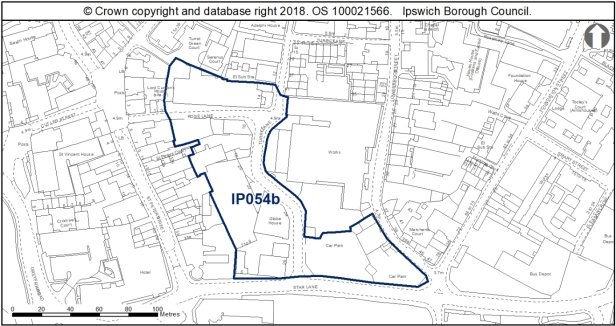
Allocation Policies SP2
|
Use(s) |
Indicative capacity |
|
|
Primary |
Housing |
40 (60dph on 60% of site) |
|
Secondary |
Small scale retail Electricity sub-station |
Some individual units up to 200sqm – subject to Core Strategy policy DM32 |
* lower than policy minimum assumed due to locational characteristics
Adopted Plan 2017
Larger site allocated incorporating the former print works. As above but residential 28 dwellings and possible public car parking included.
Current use
To the west of Turret Lane, various employment uses, car parking. To the east of Turret Lane, car parking.
Development constraints / issues
The site is within or close to an Air Quality Management Area and part within a flood zone at the southern end of the site. There are TPOs on site or nearby (an application for Tree Works may be needed). The site is also within an area of archaeological importance, partly within the Central Conservation Area, contains a scheduled monument and two grade II listed buildings (30A and 32 Lower Brook Street). The site is flanked by the rest of the Central conservation area and several listed buildings, with two grade II* churches to the south.
Whilst much of this area is not located in the Conservation Area, the allocation site nonetheless is located in the setting of the Central Conservation Area, responds to several historic ranges and outbuildings along St Peters Street, and located on land of archaeological significance. The application site is thus in a historically significant location, contributing to the setting of heritage assets, as well as being in a prominent position in the historic north/south route onto Turret Lane.
Development should look to respect the domestic scale of existing architecture along St Peters Street, and should allow breathing space between these listed buildings and new development. The winding nature of Turret Lane should be incorporated into development proposals, and should reveal the design of the scheme as users turn the corner of Turret Lane, and be of a high quality design which would help link the town centre and the waterfront.
The corner of Star Lane and Turret Lane should look to introduce a landmark building to provide interest to the street scene. The adjacent cylindrical building at the junction of St Peters Street and Star Lane serves as an example that a landmark building need not necessarily be tall or overscaled.
Development should introduce a frontage to Star Lane, although must have regard for the highly graded listed buildings to the south, and incorporate the trees which are covered by TPOs in the eastern corner of the allocation site at Star Lane. This area could perhaps be a pocket of open/amenity space, which would allow for a break in new development and the listed buildings on Lower Brook Street.
If retail units are to be incorporated into the development of this allocation site, then perhaps focussing these along Rose Lane would be most appropriate, to continue the commercial character of St Peter's Street.
Redevelopment will be dependent on the intentions of existing businesses.
Development principles for the Merchant Quarter, within which the site is located, are set out in Chapter 6 of the Site Allocations and Policies development plan document (see 'Opportunity Area B'). They include, for example, a layout to relate to the historic street pattern and enhanced pedestrian linkage between the town centre and the Waterfront. It is a key principle for the development of this site that connectivity is built in to ensure linkages with surrounding development.
There is a need to protect land for an extension to the electricity sub-station or new provision within the site. The route of Turret Lane should be protected in development proposals.
This site lies within the area of archaeological importance (IPS 413) and contains a scheduled monument (split over two separate areas) relating to the Anglo-Saxon and medieval town of Ipswich (List Entry No 1005987). Parts of the area have been investigated (IPS 214), IPS 369, and IPS 574). The latter found a wood-lined well with an assemblage of boar tusks, demonstrating good potential for the survival of wet and well preserved organic deposits. Scheduled Monument Consent (SMC) is a legal requirement for any development which might affect a monument either above or below ground level. Historic England administers the SMC application process on behalf of the Secretary of State for Digital, Culture, Media and Sport and should be consulted at the earliest opportunity to discuss the nature of the development. SMC is a separate process from the planning system.
There is also a potential for nationally important archaeological remains outside the scheduled areas. Detailed pre-application discussions with Suffolk County Council Archaeological Service and Historic England would be required in order to agree the principle of development and inform design (e.g. to allow preservation in-situ of deposits or appropriate programmes of work). Where development is accepted in principle, archaeological remains will be complex and important, and mitigation could involve significant costs and timescales.
A transport assessment and travel plan will be required.
Surface water flooding local to site - will need to be considered at planning application stage. See Appendix 1 of the Ipswich SFRA.
Although this site is currently of low wildlife value, there is a potential risk that buildings could support bats and consequently an internal inspection by a suitably qualified ecologist is recommended, which will also encompass nesting birds. To achieve biodiversity net gain, the recommendations of the Ipswich Wildlife Audit 2019 could be incorporated into future development, unless other means of biodiversity enhancement are appropriate.
(3) Site ref: IP061 (UC064) Former School Site, Lavenham Road
Site area: 0.9ha
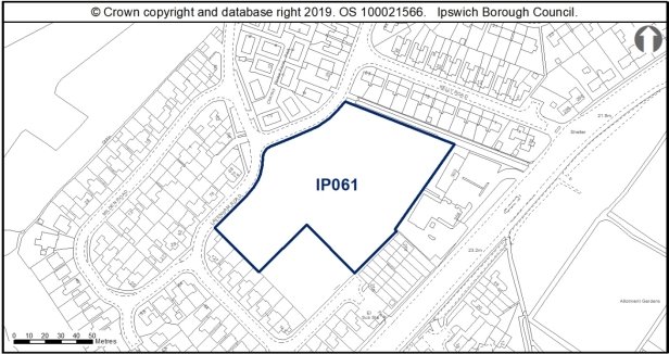
Allocation Policies SP2 & SP6
|
Use(s) |
Indicative capacity |
|
|
Primary |
Residential |
23 (40dph on 60% of site*) |
|
Secondary |
Amenity green space (on 40% of site) |
0.32ha |
* see Core Strategy policy DM23 for minimum and average densities.
Adopted Plan 2017
Larger site area (1.08ha) with residential capacity of 30 dwellings (40dph on 70% of site) and 0.32ha of amenity green space on (on 30% of site).
Current use
Open space.
Development constraints / issues
The site is no longer required for a new school. The site was identified through the Open Space Sport and Recreation Study (2009) as park and garden and is used for informal recreation. It was identified as a school site through the 1997 Local Plan. The proposal is that 70% of the site is used for housing to improve the remaining open space. The type of open space provision would need to be agreed with the Council's Parks and Open Spaces Service.
Planning permission (18/00991/FPC) was granted and works have commenced on part of the site (0.18ha) for the development of four general needs housing units and four respite care units with staff and communal areas. Development of the site allocation (0.9ha) will need to ensure that it is compatible with this adjacent permission.
In terms of archaeology, this site is in the vicinity of a Bronze Age cremation (IPS017), and Roman and Iron Age finds (IPS 034, IPS 185). It has been subject to geophysical survey and some follow up test pits which identified areas of recent overburden but did not reveal major archaeological features. Trial trenching of this site should be carried out in order to further characterise archaeological remains. Evaluation should be undertaken early in the project management to allow mitigation and investigation strategies to be developed. Sparse remains might be anticipated.
It is also adjacent to the listed building Crane Hall – development will need to have regard to the setting of the listed building.
The proposed development should respect the scale and layout of existing residential development around Lavenham Road, and address the topographical changes across the allocation site to provide a distinctive development.
This site falls within the 91.4m height consultation zones surrounding Wattisham airfield, therefore any proposed structures which may exceed this height would need to be reviewed by the Ministry of Defence.
The site provides a valuable stepping-stone habitat between Chantry Park County Wildlife Site and Gippeswyk Park in combination with London Road Allotments. With sensitive landscaping there is the opportunity to improve the quality of this stepping-stone habitat through enhancement on the remaining on-site habitat. New development should retain as much of the existing habitat as possible and integrate it within a landscaping scheme, particularly the hedgerow and mature tree along the northern boundary. To achieve biodiversity net gain, the recommendations of the Ipswich Wildlife Audit 2019 could be incorporated into future development, unless other means of biodiversity enhancement are appropriate.
Site ref: IP064a (UC064) Land between Holywells Road and Holywells Park
Site area: 1.2ha
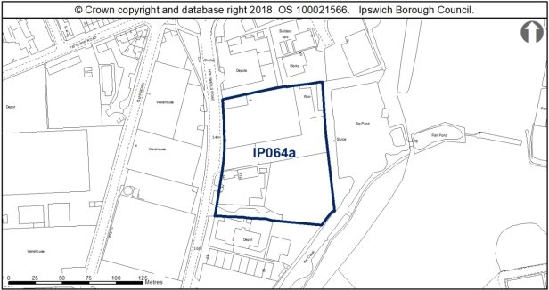
Allocation Policies SP2
|
Use(s) |
Indicative capacity |
|
|
Primary |
Residential |
66* (45dph on 100% of site) |
* see Core Strategy policy DM23 for minimum and average densities.
Adopted Plan 2017
N/A – New site (2007 preferred options UC067 was a larger site put forward for 50% residential and 50% employment uses)
Current use
Offices B1(a) and B1(c) Light industry including vehicle workshop and car sales, ancillary retail.
Development constraints / issues
The existing non-residential uses are not opposed to relocating.
The site is within an existing Employment allocation (E11) and is among the mid-performing Employment areas within the borough. There are industrial uses immediately to the west of the employment area also proposed for residential use, with vacant land to the east. There are therefore no incompatible uses.
The allocation is within 250m of the access to the safeguarded minerals facility, rather than the facility itself. The relationship with the safeguarded facility would need to be considered as part of the masterplanning and design of the allocation.
Half of E11 is potentially contaminated and therefore a contaminated land assessment would need to be carried out as part of any development. Potential for indirect impacts from water contamination, particularly during construction. The area is within a County Wildlife Site.
Approximately 50% of the site is within Flood Zone 3, although there is potential to mitigate its impact.
This area covers the former site of Fountain Cottage, a fountain, and two ponds, as shown on historic maps, which also show earlier buildings. Documentary evidence suggests that there was a water mill on the site from at least 1580, and possibly earlier (county Historic Environment Record IPS 497). It would appear that the ponds were a continuation of a water management system now within Holywells Park. Historically, the site falls within the manor of Wyx Bishop. The history of the site and the relationship it has to Holywell's Park and the earlier medieval and 16th-18th century landscape should be understood. The impacts of more modern change and use are not known. Setting impacts on Holywells Park should be considered. Desk-based assessment should be undertaken ahead of any planning application, which will inform the nature and timing of any field assessment. Conservation of historic features may be appropriate.
Redevelopment to explore scope for additional access into Holywells Park.
This allocation site is an area of 20th warehousing located to the immediate west of Holywells Park Conservation Area, which bounds the site with a dense covering of mature vegetation to the east. The existing units and use of the site have little street scene or townscape interest, and the redevelopment of this site with a planned development would be welcomed.
Development should be of a domestic scale so as not to be visible in views out of the Holywells Park Conservation Area to the west. The development of the site should introduce an active and engaging frontage to Holywells Road, and should take a contemporary architectural approach in design and should look to borrow architectural influences from successful nearby residential schemes, such as the Patteson Road/John Street development to the northwest. A traditional grid layout would likely be more appropriate than a cul-de-sac.
The development of the site could look to provide a new pedestrian access to Holywells Park for members of the public entering from the west. This route would need to be integral to the design of the redevelopment scheme using hard and soft landscaping to direct users through the site and to the access.
As the site is located adjacent to Holywells Park CWS the eastern boundary should be buffered from any development. There is an opportunity to strengthen the local ecological network by siting any new greenspace adjacent to the Park. Due to the proximity of the park, the lighting scheme should be designed to prevent light spillage into this area. Bats are particularly sensitive to increased light levels, so it is important to maintain dark corridors to support local ecological networks. To achieve biodiversity net gain, the recommendations of the Ipswich Wildlife Audit 2019 could be incorporated into future development, unless other means of biodiversity enhancement are appropriate. The site is in close proximity to the Stour and Orwell SPA/ Ramsar site. Information to inform a project level HRA will be required to demonstrate that urbanisation impacts on the site are prevented.
Site ref: IP066 (UC069) JJ Wilson, White Elm Street
Site area: 0.85ha (includes land adjacent to the east not previously included)
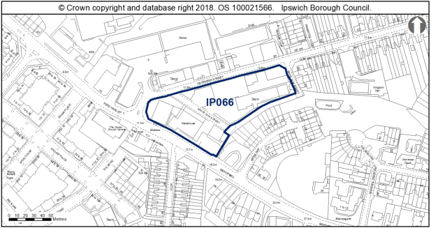
Allocation Policy SP2
|
Use(s) |
Indicative capacity |
|
Residential |
55 (65dph) |
* see Core Strategy policy DM23 for minimum and average densities.
Adopted Plan 2017
100% housing at medium density – 18 dwellings on portion fronting Bishops Hill only, land to the rear at Cavendish Street is a new site.
Current use
Warehousing, car park.
Development constraints / issues
Need to relocate the existing businesses first.
Possible contamination and close to an AQMA. Surface water flooding local to site - will need to be considered at planning application stage. See Appendix 1 of the Ipswich SFRA. Any greenspace provision should be located at the north-eastern end of the site as this is closest the area of offsite, private seminatural habitat. To achieve biodiversity net gain, the recommendations of the Ipswich Wildlife Audit 2019 could be incorporated into future development, unless other means of biodiversity enhancement are appropriate. It should be noted that Japanese Knotweed has been recorded on this site and this should be addressed as a matter of urgency to avoid any worsening of this and prevent spreading to other sites.
This allocation site comprises 20th century warehousing located to the east of the town centre, and bounded by dense, mature vegetation to the east, historically associated with Uplands Gate, a large listed dwellinghouse on Bishop's Hill.
Before developed for warehousing, this allocation site was occupied by terrace housing along Cavendish Street, Bishop's Hill and around White Elm Street, which once formed a grid. Reinstating housing along the historic street pattern would be encouraged in the redevelopment of this site.
Adjacent dwellinghouses are principally laid out in terraces, and so rows of terraces would be recommended, or perhaps shorter rows of 4 units if continuous terracing could not be accommodated. A contemporary design approach would be encouraged, whilst still respecting the character of 19th century terracing which borders the site on Cavendish Street. In this regard, a red brick construction would be encouraged, however the masonry bond could be experimented with to provide textured brickwork to contrast the more traditional terrace design.
Proposals would need to consider the change in topography over the site, particularly along Bishop's Hill to the south east. Stepping the height of the units would help illustrate this topographical change.
Site ref: IP067a & b (UC070) Former British Energy Site, Cliff Quay
Site area: 0.38ha Residential, 4.18ha Industrial
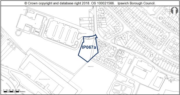
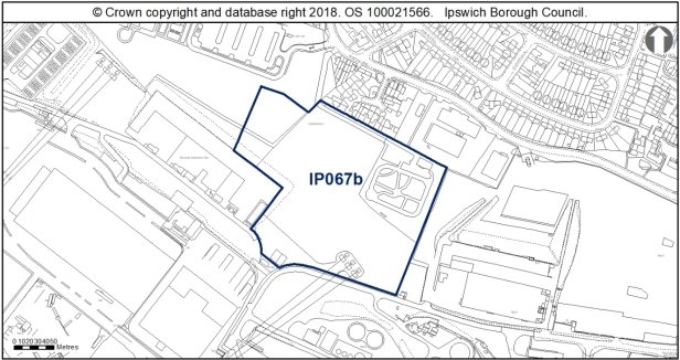
 Allocation Policy SP2 & SP5
|
|
Use(s) |
Indicative capacity |
|
Primary IP067b |
Industrial (B-Class) and appropriate employment-generating sui generis uses as defined through policy DM33 |
20,000sqm |
|
Secondary IP067a |
Residential |
17 (45dph) |
* see Core Strategy policy DM23 for minimum and average densities.
Adopted Plan 2017
Allocated for industrial uses, 20,000sqm. Site has now been split
Current use
Vacant former British Energy Site
Development constraints / issues
Access constraints, odour from the sewage works, possible contamination and the site is within a Landfill Consultation Zone. It is adjacent to a County Wildlife Site, contains part of a Local Wildlife Site and forms part of the ecological network. An ecological and reptile survey will be needed prior to any vegetation clearance and mitigation where appropriate. The site is in close proximity to the Stour and Orwell SPA/ Ramsar site. Information to inform a project level HRA will be required to demonstrate that urbanisation impacts on the site are prevented.
In terms of archaeology, this site overlooks the Orwell, in a topographically favourable location in the vicinity of prehistoric sites, particularly of Palaeolithic date. There is no objection in principle to development but any permission will require a condition relating to archaeological investigation. A desk-based assessment is recommended in the first instance.
Water infrastructure and/or treatment upgrades will be required to serve the proposed growth or diversion of assets may be required.
Surface water flooding local to site - will need to be considered at planning application stage. See Appendix 1 of the Ipswich SFRA.
A transport assessment and travel plan will be required. Development of IP067b is likely to require signal control of Landseer road/ Sandyhill Lane as a means of mitigation. Toucan facilities in signals also represent an opportunity to improve sustainable access.
The site may be suitable for housing at the northern most end, adjacent to the existing housing granted in 1999 for the adjacent site on Pipers Vale Close. This is now fully built out.
The Valley Urban Characterisation Study SPD notes that existing industrial development has encroached on areas of former meadow and foreshore, and that it is important that future development improves access and provides open space and connections to the waterside.
IP067a would be more appropriate to residential development, so that the dwellinghouses will read in the context of existing residential units at Pipers Vale Close and Sandyhill Lane, and reflect the semi-detached layout of the surrounding area.
IP067b would be better suited to larger scale industrial uses. Opportunities for robust modern design which responds to the commercial heritage of the area should be encouraged. The provision of development with green roofs could assist in providing habitats for wildlife, whilst also help softening the often utilitarian character of industrial development, and also the outlook towards the river valley.
Opportunities to create sightlines through the site and across the estuary towards the Orwell Bridge should be incorporated into development proposals where possible.
Prior to any removal of vegetation or excavation, a preliminary ecological appraisal of the site, along with any required species specific surveys will need to be undertaken. To achieve biodiversity net gain, the recommendations of the Ipswich Wildlife Audit 2019 could be incorporated into future development, unless other means of biodiversity enhancement are appropriate.
Site Allocations Plan Review: Appendix 3 – Site sheets (Part Two)
Site ref: IP080 (UC085) 240 Wherstead Road
Site area: 0.49ha
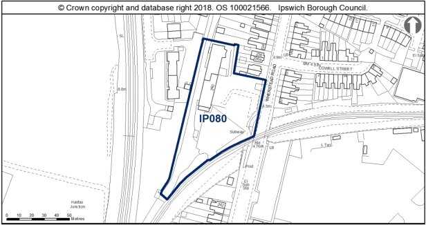
Allocation Policy SP2
|
Use(s) |
Indicative capacity |
|
Residential |
27 (55dph*) |
* see Core Strategy policy DM23 for minimum and average densities.
Adopted Plan 2017
As above
Current use
Vacant land and buildings.
Development constraints / issues
The site is in close proximity to the Stour and Orwell SPA/ Ramsar site. Information to inform a project level HRA will be required to demonstrate that urbanisation impacts on the site are prevented.
The layout should support the wildlife corridor function of the railway line. There is an opportunity to strengthen the local ecological network by enhancement of onsite habitats adjacent to this feature. As such any residential lighting scheme should be designed to prevent light spillage into this area. An ecological appraisal of this site should be undertaken prior to any clearance of vegetation, along with any specific surveys highlighted in the report. These are likely to include, but not be limited to, reptiles, bats and badgers. Given the nature of the site this should also encompass the potential for invasive plant species. To achieve biodiversity net gain, the recommendations of the Ipswich Wildlife Audit 2019 could be incorporated into future development, unless other means of biodiversity enhancement are appropriate.
Possible contamination and adjacent to a flood zone. Also noise from the adjacent railway line. Surface water flooding local to site - will need to be considered at planning application stage. See Appendix 1 of the Ipswich SFRA.
There is no archaeological objection in principle to development, but any permission may require an archaeological condition, subject to development details. This site is in the vicinity of Palaeolithic deposits, including the SSSI of the Stoke Bone Bed (IPS 163, IPS 468). It will require desk-based assessment in the first instance.
Development to explore the possibility of providing a pedestrian and cycle link through to Wherstead Road from the existing housing to the west.
The site is close to uses which are safeguarded through the Suffolk Minerals Core Strategy. The allocation is within 250m of the access to the safeguarded minerals facility, rather than the facility itself. The relationship with the safeguarded facility would need to be considered as part of the masterplanning and design of the allocation.
The site features a steep rise in topography from Wherstead Road, which would require careful consideration in the development of this site, to avoid the erection of buildings on site levels which would overshadow or dominate the existing development.
Development of this allocation site should look to improve the appearance of the subway, and the area of landscaping which surrounds it.
Site ref: IP083 (UC089) Banks of river upriver from Princes Street
Site area: 0.76ha
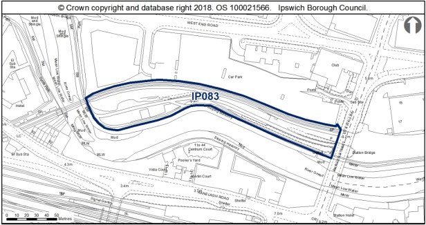
Allocation Policy SP6
|
Use(s) |
Indicative capacity |
|
|
Primary |
Public open space |
- |
Adopted Plan 2017
As above.
Current use
River path, overgrown areas, disused railway tracks.
Development constraints / issues
The site is close to a County Wildlife Site (the River). A survey for reptiles is recommended if any suitable habitat is to be impacted by development. There is an opportunity to strengthen the local ecological network by encouraging further growth of scrub and grassland habitat in species poor amenity grassland areas offsite to the west. To achieve biodiversity net gain, the recommendations of the Ipswich Wildlife Audit 2019 could be incorporated, unless other means of biodiversity enhancement are appropriate.
Depending on the nature of groundworks, there may be a requirement for a condition relating to archaeological works on this land on the edge of the river.
The design will need to avoid light spillage in the river corridor.
A cycle path should be provided through the southern part of the site as part of a continuous path along the River Gipping. FP61 is recorded along the site's southern and western boundaries. In accordance with the aspiration to provide cycling along the River Path, the development should support the upgrade to BR or conversion to cycle track. Sections of the route may also need physically widening.
Replacing the retaining walls covered by graffiti in particular would be encouraged, whilst wider footpaths with improved lighting and access from Princes Street bridge would also be beneficial to the appearance and amenity value of the river path.
There is presently a piece a public art, The Navigator, which occupies the western section of the site, which would need to retained or moved to the lower river path, with the space around the public art landscaped to improve the experience of the sculpture.
(1) Site ref: IP089 (UC096) Waterworks Street
Site area: 0.3ha
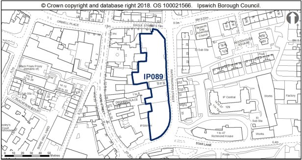 Allocation Policy SP2
|
Use(s) |
Indicative capacity |
|
Residential |
23 (90dph* less 5 existing houses) |
* see Core Strategy policy DM23 for minimum and average densities.
Adopted Plan 2017
As above
Current use
Car park
Development constraints / issues
The site is partly within Central Conservation Area and adjacent to listed buildings. It contains a fragment of the Ipswich Ragged School, founded in 1849.
TPOs on site (an application for Tree Works may be needed), possible contamination and close to an Air Quality Management Area. May need to incorporate some parking at northern end of site to Co-op Education Centre. Surface water flooding local to site - will need to be considered at planning application stage. See Appendix 1 of the Ipswich SFRA.
This site is a large area in the Anglo-Saxon and Medieval core and within the Area of Archaeological Importance (IPS 413). Detailed early pre-application discussions with Suffolk County Council Archaeological Service would be required to agree the scope of required assessment and to inform design (e.g. to allow for preservation in-situ of deposits or appropriate programmes of work). Archaeological remains may be complex and important, and mitigation could involve significant costs and timescales.
Sections of this allocation site are located within the Central Conservation Area, with the excluded areas falling within the setting of the Conservation Area. The site includes the façade of the Boys Ragged School, a Victorian building, although this has been principally demolished and extended. The site is bounded to the west by the rear ranges of numerous listed buildings along Fore Street, and to the east 13-33 Waterworks Street, which is a grade II listed terrace.
More modern development generally exists to the east of the allocation site, and so this site is an important transitionary area between the historic core of the town and the 20th century redevelopment of the edges of the town centre. Development proposals therefore must have regard for the sensitive historic context of this allocation site.
Development should look to reinstate a building frontage to Waterworks Street, respecting the 2-2.5 storey scale of surrounding development. The former ragged school should be integrated into development proposals, although a more modern design approach would be encouraged, perhaps using traditional materials in a more contemporary way. The north and south corner plots could both accommodate more of a landmark building to frame the development, however should still be of a scale which respects the scale of adjacent buildings, and historic character of the area.
Owing to the setback position of 11 Fore Street, and that the land to the east of this building has historically been undeveloped and used as the garden to the listed building, development around to the rear of this building requires particular attention, and should provide a respectable buffer to allow for breathing room between new development and the listed building.
Although this site is currently of low wildlife value, we strongly recommend the retention of the mature trees on site. In addition, the buildings could support bats and consequently further surveys are recommended. The lime tree should also be assessed for potential bat roosting features. To achieve biodiversity net gain, the recommendations of the Ipswich Wildlife Audit 2019 could be incorporated into future development, unless other means of biodiversity enhancement are appropriate.
Site ref: IP094 (UC104) Land to rear of Grafton House
Site area: 0.31ha
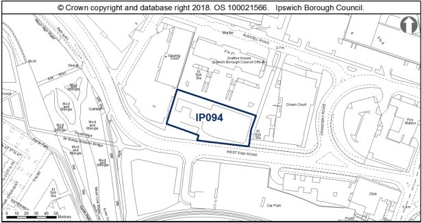
Allocation Policy SP5
|
Use(s) |
Indicative capacity |
|
B1a (office) |
3,000sqm |
Adopted Plan 2017
As above
Current use
Vacant site
Development constraints / issues
Access constraints, possible contamination, flood risk and there is a TPO adjacent to the site (an application for Tree Works may be needed). Surface water flooding local to site - will need to be considered at planning application stage. See Appendix 1 of the Ipswich SFRA. A transport assessment and travel plan will be required. An alternative link to Constantine Road should be investigated with a potential opening up of the West End Road/ Constantine Road junction to address possible access issues from West End Road. There is no archaeological objection in principle to development, but any permission may require a condition relating to archaeological investigation, depending on the nature of the groundworks.
This site is used as car parking and for the temporary storage of building materials, and is bounded to the south by hoardings and scrub. To the south east of this building is the grade II listed Paul's Maltings, prominent in the landscape owing to its long façade and kiln. Development of this site must therefore have regard for the setting of this listed building.
The development of this site should look to enhance West End Road with an active and engaging frontage, which reflects the contemporary character and appearance of the more recent introductions to the Portman Quarter area.
Parking should be concentrated to the rear of the site to allow the built development to have a greater street scene presence, rather than being set back by car parking.
Proposals should be sensitively designed to relate to Grafton House, so as not to completely obscure the outlook and appearance of this dual frontage building.
An ecology survey should be completed and submitted alongside an application for development.
Site ref: IP096 (UC109) Car Park, Handford Road East
Site area: 0.22ha
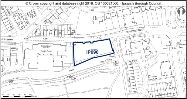
Allocation Policy SP2.
|
Use(s) |
Indicative capacity |
|
Residential |
22 (100dph*) |
* see Core Strategy policy DM23 for minimum and average densities.
Adopted Plan 2017
As above
Current use
Car park (temporary permission 18/00384/FUL).
Development constraints / issues
Within the Portman Quarter, housing densities should be high (Policy DM23) therefore the capacity has been increased. The development by McCarthy and Stone on the site to the west also suggests that high density may be appropriate here. Design and layout would need to support the wildlife corridor function of the canal which is also a County Wildlife Site and Local Nature Reserve. The site is part within the flood plain. There is also possible contamination on site. Surface water flooding local to site - will need to be considered at planning application stage. See Appendix 1 of the Ipswich SFRA.
This site is close to Roman, Anglo-Saxon and prehistoric excavated sites. It has a high potential for archaeological remains. Detailed early pre-application discussions with Suffolk County Council Archaeological Service would be required to agree the scope of required assessment and to inform design (e.g. to allow for preservation in-situ of deposits or appropriate programmes of work). Archaeological remains may be complex and important and mitigation could involve significant costs and timescales.
The site is opposite Burlington Road Conservation Area.
Development must take account of the River Corridor Buffer (10m) where no development should take place.
The site is located to the south of the Burlington Road Conservation Area, and is an important route when travelling into Ipswich from the west, marking the entrance to the more built up part of the town.
The north of Handford Road is generally well landscaped gardens associated with the large late 19th and early C20th dwellings built on Dalton Road, including the grounds of the grade II listed Firbank. The red brick boundary walls to the rear of the properties on Dalton Road run the length of Handford Road. The south side of Handford Road comprises more recent buildings, generally 3 storey apartment brick buildings. To the south of the application site is the canal and Alderman Road Recreation Ground. The site is bounded to the east by an area of public space which cuts through to the park, which is contemporary in its approach with a geometric central space and modern lighting scheme.
Development of the allocation site is welcomed, as a building would contribute to the street scene and infill an otherwise vacant plot.
There is scope for a more contemporary design of landmark status on this site, particularly as the site occupies a prominent corner plot. The area of public space to the east lends itself to a more modern architectural approach in the design of the building. Care should also be taken to ensure that the proposed building addresses the elevation to the east onto Alderman Road which should contribute positively to the public space. A contemporary, expressive design would have a greater contribution to the street scene, and contrast the more regular designs of adjacent C20th architecture.
In designing the appearance and layout of the building, care should also be taken to utilise the canal to the south, addressing the canal with an expressive frontage which would be visible in views from the canal side walk.
New development should retain as much of the existing habitat as possible and integrate it within a landscaping scheme, particularly the tree belt along the southern boundary adjacent to the Alderman Canal CWS. The trees along the southern boundary should be assessed for their potential to support bat roost. The recommendations of the Ipswich Wildlife Audit 2019 could be incorporated into future development, unless other means of biodiversity enhancement are appropriate.
(1) Site ref: IP098 (UC111) Transco south of Patteson Road
Site area: 0.57ha
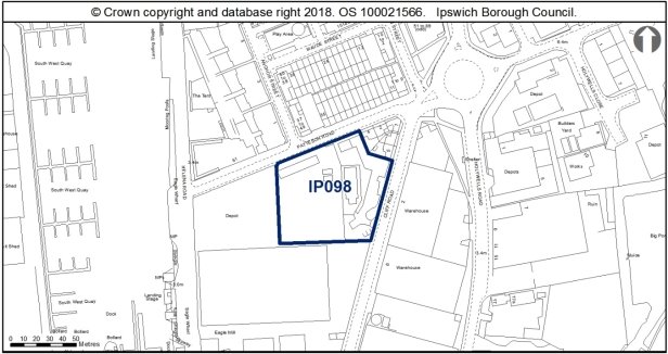
Allocation Policy SP2
|
Use(s) |
Indicative capacity |
|
Residential |
62 (110dph DM23 higher end of range) |
* see Core Strategy policy DM23 for minimum and average densities.
Adopted Plan 2017
As above
Current use
Gas governor.
Development constraints / issues
Need to relocate the existing gas governor first.
Flood risk, contamination and close to an Air Quality Management Area. Surface water flooding local to site - will need to be considered at planning application stage. See Appendix 1 of the Ipswich SFRA.
This site lies on the edge of the channel of the Orwell. There is potential for buried historic deposits. There is no archaeological objection in principle to development, but any permission will require a condition relating to archaeological investigation.
The site is close to uses which are safeguarded through the Suffolk Minerals Core Strategy.
This allocation site is located to the east of the Wet Dock Conservation Area, and to the west of the Holywells Park Conservation Area. The site currently holds low amenity value, with the western half containing the gas converter, and east used as a builders yard, and is bounded by a high brick wall.
The site occupies frontages onto Cliff Road and Patteson Road, with the corner of these roads being occupied by early 20th century ex-gas worker's cottages (which fall outside of the allocation site). To the north of the allocation site is a recent development which utilises traditional building forms, polychrome brick banding and timber weatherboarding which has introduced interesting architectural detailing to the area, which the development of this site should look to respond to. The use of masonry utilising textured and polychromatic brick bonds in the redevelopment of this allocation site would allow for the site to be distinctive whilst also relating to the existing development to the north.
Proposals should ensure that new buildings have active elevations to both Patteson Road and Cliff Road which provide visual interest to the street scene, avoiding repetitive fenestration schemes and external finishes.
High quality design and finish of development is expected to respond positively to the character of the area, and enhance the setting of the adjacent Conservation Areas.
To achieve biodiversity net gain, the recommendations of the Ipswich Wildlife Audit 2019 could be incorporated into future development, unless other means of biodiversity enhancement are appropriate.
Site ref: IP105 (UC129) Depot, Beaconsfield Road
Site area: 0.33ha
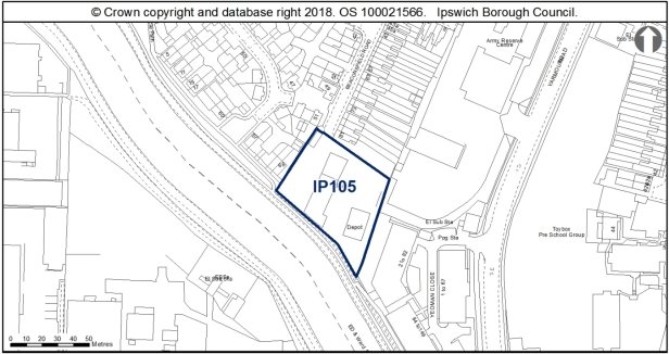
Allocation Policy SP2
|
Use(s) |
Indicative capacity |
|
Residential |
15 (45dph*) |
* see Core Strategy policy DM23 for minimum and average densities.
Adopted Plan 2017
As above
Current use
Depot.
Development constraints / issues
Need to relocate the existing business first.
The site lies within a flood zone and a Landfill Consultation Zone. Possible contamination. The design and layout would need to address the river frontage and support its wildlife corridor function. The recommendations of the Ipswich Wildlife Audit 2019 could be incorporated into future development, unless other means of biodiversity enhancement are appropriate.
This site affects an area of archaeological interest, on land formerly in the low lying plains of the River Gipping. There is potential for palaeo-environmental remains to exist. Saxon remains were recorded at IPS 395 in a similar topographic location to the site, 250m to the west. There is no objection in principle to development, but any permission will require a condition relating to archaeological investigation. A desk-based assessment in the first instance will establish impacts of past land use.
This site falls within the 91.4m height consultation zones surrounding Wattisham airfield, therefore any proposed structures which may exceed this height would need to be reviewed by the Ministry of Defence.
A cycle path should be provided along the south west boundary of the site, linking with the existing riverside cycle paths to the north and south of the site.
Development must take account of the River Corridor Buffer (10m) where no development should take place.
This allocation site is a depot located at the end of the principally residential Beaconsfield Road, an area of early 20th terraces housing to the east and more recent development to the west.
A residential use of this allocation site would be more in keeping with the character of the area, and should contribute positively to the streetscene, as well as provide an active frontage to the River Gipping, improving the southern boundary of the allocation site and its appearance from the river path.
Site ref: IP119 Land east of West End Road
Site area: 0.61ha
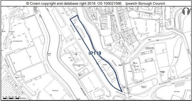
Allocation Policies SP2
|
Use(s) |
Indicative capacity |
|
|
Primary |
Residential |
28 (100dph on 45% of site) |
|
Secondary |
Leisure Employment |
40% of site 15% of site |
* see Core Strategy policy DM23 for minimum and average densities.
Adopted Plan 2017
N/A – New site (See Preferred Options 2007 UC199 for 100% medium density housing, 51 homes)
Current use
Car sales and vacant site.
Development constraints / issues
Residential capacity calculated on the basis of 45% of the site being developed to allow the layout to take account of substation opposite to the west and provide visual buffering. It is likely to come forward on the southern portion of the site. Development must address river frontage and enhance public access to the river. An indicative capacity of 40% of what is likely to be the central element of the site has been allocated for leisure use which is likely to be in the form of a river-related activity given the ability to access the river at this specific location. 15% of the site is allocated for employment uses and this is likely to come forward on the northern-most part of the site.
A bat survey should be carried out before any works commence. If the site is left for any significant period of time so that the northern part of the site becomes more vegetated, then a reptile survey should also be undertaken. However, woody vegetation clearance must take place outside bird nesting season (March – end of August inclusive), unless immediately preceded by a nesting bird check undertaken by a suitably qualified ecologist. To achieve biodiversity net gain, the recommendations of the Ipswich Wildlife Audit 2019 could be incorporated into future development, unless other means of biodiversity enhancement are appropriate.
Depending on the nature of proposed groundworks, a condition relating to a programme of archaeological work may be applied to planning consents, with desk-based assessment and palaeoenvironmental assessment in the first instance.
Part of the site is located in Flood Zone 3 but benefits from flood defences. A Flood Risk assessment would be required for any new development on site.
Riverside cycle paths to the north and south of the site. For Development Guidelines see Opportunity Area G. FP62 is recorded running along the entire length of the site's eastern boundary.
Development must take account of the River Corridor Buffer (10m) where no development should take place. Development in this location should seek to enable greater recreational, leisure and sports use of the River Gipping, for example though the provision of 'portage' easy river access and facilities including possible canoe/ kayak/ boat storage facilities. Given the fairly static and relatively unclean quality of the water here, efforts to minimise refuse and food waste should be considered as part of this to make this section of the river more amenable to recreational and leisure use.
This site is partially vacant, with the southern area used for car showrooms and industrial uses. West End Road is an important arterial route into and out of the town, and so the comprehensive redevelopment of this site is encouraged, and should make a positive architectural statement.
Proposals should consider the long principal frontage onto West End Road, and avoid a single scale and repetitive approach to fenestration directly adjacent to the highway. A varied approach to design and scale should help break up the massing of the proposed development, utilising smaller scale modules, fenestration and a varied finish to provide a visually interesting scheme which would not dominate the street scene.
This site also backs onto the River Gipping Riverside Walk, and so development proposals should address this east elevation with an active and engaging frontage which contributes positively to the riverside walk and to the enjoyment of users of the river.
Development of this site should also look to incorporate biodiversity enhancements.
Site ref: IP120b Land west of West End Road
Site area: 1.03ha
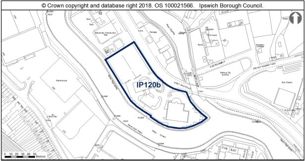
Allocation Policy SP2
|
Use(s) |
Indicative capacity |
|
Residential |
103 (125dph on 80% of the site) |
* see Core Strategy policy DM23 for minimum and average densities.
Adopted Plan 2017
N/A – New site. Considered at Preferred Options 2007 site UC201 for 100% housing at medium density (57 dwellings).
Current use
Car showrooms.
Development constraints / issues
Existing uses would need to relocate.
Part of the site is located in Flood Zone 3 but benefits from flood defences. A Flood Risk assessment would be required for any new development on site.
Providing access to the river frontage, and relating well to nearby residential developments across the river will be requirements. For Development Guidelines see Opportunity Area G.
The adjacent River is a County Wildlife Site. It is also a key part of the Wildlife Network. There is an opportunity to strengthen the local ecological network by enhancement of onsite habitats adjacent to this feature. The scrub along the river provides valuable habitat for birds and as much as possible should be retained. Further bird surveys should be undertaken. To achieve biodiversity net gain, the recommendations of the Ipswich Wildlife Audit 2019 could be incorporated into future development, unless other means of biodiversity enhancement are appropriate. Potential contamination on the site. 80% of the site assumed available to allow the layout to visually buffer the nearby substation.
Depending on the nature of proposed groundworks, a condition relating to a programme of archaeological work may be applied to planning consents, with desk-based assessment and palaeoenvironmental assessment in the first instance.
Development must take account of the River Corridor Buffer (10m) where no development should take place.
The allocation site has the potential for a contemporary landmark residential development at the southern point where the two rivers meet. Proposals would need to address both principal frontages, maximising the relationship with the River Orwell. The repetitive design and single volume massing of the flats opposite on Ranelagh Road should be avoided, with a more bespoke approach design approach being employed for this landmark site.
The electricity substation should be integrated into development proposals and be screened by a well-designed enclosure so as not to detract from the residential development of the allocation site.
A scheme should look for opportunities for biodiversity enhancements and provide a riverside walk along the Orwell to provide an island loop for pedestrian access.
Site ref: IP125 Corner of Hawke Road and Holbrook Road
Site area: 0.25ha
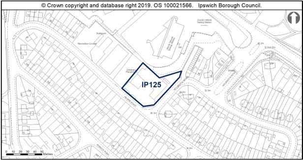
Allocation Policy SP2
|
Use(s) |
Indicative capacity |
|
|
Primary |
Residential |
15 (60dph) |
* see Core Strategy policy DM23 for minimum and average densities
Adopted Plan 2017
N/A – new site
Current use
The site is currently leased for business use, but this lease is coming to an end, providing an opportunity for the site to come forward for residential use.
Development constraints/issues
Land to the rear has been granted permission for use as a builder's yard, therefore it is important that existing boundary trees are retained to the rear and supplemented, and consideration is given to noise reduction measures if required.
New Planning Regulations require that the biodiversity connected with the site should be increased by 10% and that this is incorporated into any biodiversity statement and landscaping scheme connected with site development. Site development will require contribution to upgrading the adjacent play area to the site.
The site may be subject to site contamination connected with previous site uses which will require further investigation.
(1) Site ref: IP132 Former St Peter's Warehouse, 4 Bridge Street
Site area: 0.18ha
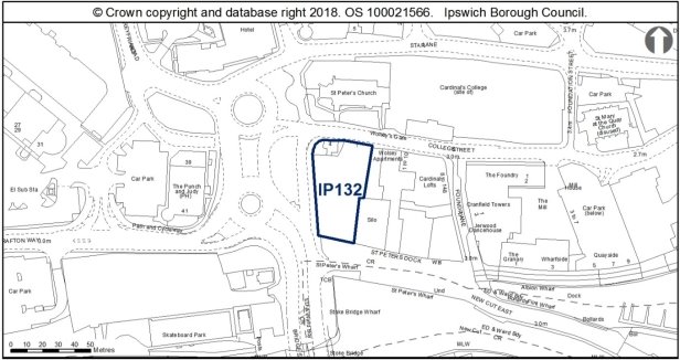
Allocation Policy SP2
|
Use(s) |
Indicative capacity |
|
|
Primary |
Residential |
73 (high end of high density range expected) |
|
Secondary |
Offices (B1a) Leisure / Retail (small scale) |
Subject to layout of site - assume commercial uses on 2 lower floors |
* see Core Strategy policy DM23 for minimum and average densities.
Adopted Plan 2017
As above
Current use
Temporary car park.
Development constraints / issues
The site contains the grade II listed No. 4 College Street and lies within an area of archaeological importance and the Central Conservation Area. It is located adjacent to the Wet Dock Conservation Area and close to, and within the setting of, the grade II* listed Church of St Peter and the scheduled monument of Wolsey's Gate.
The site lies in an area of archaeological importance (IPS 413), on the Anglo-Saxon and medieval waterfront of Ipswich. This site potentially represents that last surviving section of 'early' waterfront. There is high potential for archaeological remains of possible national significance, such as important waterlogged remains and the potential remains of bridges dating from at least the 10th century.
Detailed early pre-application discussion with Suffolk County Council Archaeological Service andHistoric England would be required to agree the scope of required assessment, the principle of development and to inform design (e.g. to allow for preservation in-situ of deposits or appropriate programmes of work). Where development is accepted in principle, archaeological remains will be complex and important and mitigation could involve significant costs and timescales.
The site is within Flood Zones 2 and 3 and within the Air Quality Management Area.
The site is expected to require improvements to the existing water supply and foul sewerage networks to enable development.
This allocation site includes the grade II listed 4 College Street, which has been on the County's Buildings at Risk Register for a considerable period of time. Development of this site which would facilitate the repair and reuse of 4 College Street is therefore encouraged, and proposals for the development of this allocated site should include a comprehensive scheme of repairs for this building.
In designing a scheme for this allocation site, attention should be paid to its sensitive location, which not only includes the grade II listed 4 College Street, but also sits to the immediate south of several highly significant heritage assets including the grade II* listed St Peter's Church, grade I and Scheduled Ancient Monument of the Gateway to Wolsey's College, the grade II 1-5 College Street. In addition, the site is located within the Central Conservation Area, adjacent to the Stoke Conservation Area and the gateway to the waterfront and Wet Dock Conservation Areas. This allocation site is thus in a particularly sensitive position, and development on the site will have the potential to affect the significance of numerous heritage assets through introducing development within their setting. As such, a sensitive approach to design, scale and massing would be required in the development of a proposal.
A smaller scale development to the north of the site onto College Street would be encouraged, to reinstate an active frontage which would respect the scale of the 1-5 and 4 College Street. The development could then increase in scale southwards towards the waterfront. Any future proposals should also offer 4 College Street breathing space, and avoid overdevelopment which would give the listed building a contrived curtilage, or being dominated by over scaled development to the south.
The scheme should present active frontages which address the west elevation, as well as those which would front onto College Street and the waterfront, and make a positive architectural statement acting as a landmark development which signals the gateway to the waterfront.
Development of this site should also consider the heritage and design comments provided on the allocated site references IP136 and IP035.
Site ref: IP133 (N/A) South of Felaw Street
Site area: 0.37ha
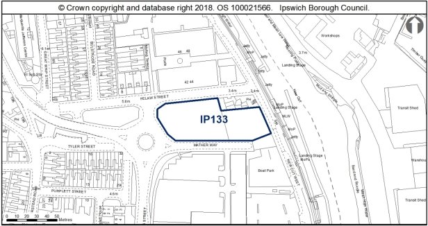
Allocation Policy SP2
|
Use(s) |
Indicative capacity |
|
Residential |
45 (120dph based on 10/00418/VC for 47 dwellings expired Feb 2014 & pre-application discussions) |
DM23Adopted Plan 2017
As above
Current use
Grassed area.
Development constraints / issues
Site previously had permission for 47 flats and ground and first floor commercial uses B1, A3 and retail with underground car park (now lapsed). Site lies within the Ipswich Waterfront in Flood Zones 2 and 3.
This site is located adjacent to the River Orwell CWS. New development should retain as much of the existing habitat as possible and integrate it within a landscaping scheme. Greenspaces should be interlinked to provide functional ecological corridors for a range of species and as much as possible they should connect with wider offsite ecological networks, particularly the River Orwell CWS. To achieve biodiversity net gain, the recommendations of the Ipswich Wildlife Audit 2019 could be incorporated into future development, unless other means of biodiversity enhancement are appropriate.
The site is adjacent to the Wet Dock Conservation Area. The grade II listed Felaw Maltings is also located to the north of the site, occupying a prominent position on the west bank of the waterfront, whilst adjacent to the maltings is the 1914 Wm Paul Tenement Trust row of cottages. The site also wraps around the Steamboat Tavern, an early 20th century public house, which is also within the Wet Dock Conservation Area.
This site lies close to Anglo-Saxon remains (IPS 683, IPS 230) and within the Area of Archaeological Importance (IPS 413). Detailed early pre-application discussions with Suffolk County Council Archaeological Service would be required to agree the scope of required assessment and to inform design (e.g. to allow for preservation in-situ of deposits or appropriate programmes of work). Archaeological remains may be complex and important and mitigation could involve significant costs and timescales.
Surface water flooding local to site - will need to be considered at planning application stage. See Appendix 1 of the Ipswich SFRA.
On-site open space provision will be required in accordance with policy DM6.
The site is close to uses which are safeguarded through the Suffolk Minerals Core Strategy.
Development principles for the Island Site (incorporating part of the 'Over Stoke' area) are set out in chapter 6 of the plan (see Opportunity Area A).
A contemporary design approach for the development of this site would be encouraged, taking design influences from the modern architectural precedent from recent development along the west bank of the waterfront.
A bespoke approach to design of development on this site will be required, to both respect the height of the Steamboat Tavern which the site wraps around, whilst also being of a scale and design which has a presence which contributes positively to the appearance of the Wet Dock, visible in views across the Conservation Area. Perhaps a stepped approach to the scale of development to break up the massing of development would assist with this. If the scheme were to include a modest tower element, then perhaps the indicative housing density could be increased.
Development must also respond to the grade II maltings to the north, and be of an appropriate scale so as not to provide a tunnel effect to Felaw Street, nor harm the significance of the listed building through the introduction of development which would compete with the maltings' prominence.
The design of new development should also address Mather Way and the roundabout to the west with a distinctive, landmark design which contributes positively to the street scene and setting of the Wet Dock Conservation Area.
Site ref: IP135 (UC 250) 112-116 Bramford Road
Site area: 0.17 ha
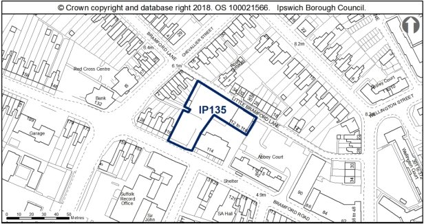
Allocation Policy SP2
|
Use(s) |
Indicative capacity* |
|
|
Primary |
Residential |
19 (110dph based on location within Local Centre) |
* see Core Strategy policy DM23 for minimum and average densities
Adopted Plan 2017
As above
Current use
Car sales
Development constraints / issues
No requirement for archaeology. Previous monitoring revealed disturbance and clean sands.
Opposite a listed building.
TPOs on the site (an application for tree works may be required). Possible contamination.
The site is expected to require improvements to the existing water supply and foul sewerage networks to enable development.
This allocation site is located opposite the grade II listed Suffolk Record Office on Bramford/Gatacre Road, a 19th century former school building with prominent street frontages utilising polychromatic brickwork with decorative terracotta detailing. The allocation site also includes TPO hornbeams along the Bramford Road frontage of the site.
Development of this allocation site should provide a frontage to Little Bramford Lane, as well as Bramford Road with expressive facades which contribute positively to the street scene. The design and layout of the buildings should reflect the linear layout of adjacent development, whilst the scale should reflect the existing domestic scale of adjacent terraced housing.
The TPOs to the front of the site will need to be integrated into the design proposals, ensuring that any new development along Bramford Road has an attractive outlook.
A contemporary design approach would be welcomed, perhaps interpreting the architectural influences of the Suffolk Record Office, particularly with regard to masonry and decorative/textured brickwork bonds to provide visual interest to the proposed development.
(1) Site ref: IP136 (UC251) Silo, College Street
Site area: 0.16ha
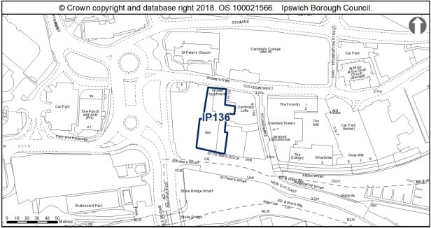
Allocation Policy SP2
|
Use(s) |
Indicative capacity |
|
|
Primary |
Residential |
48 (assumed 10 storey building with c. 6 flats per floor and commercial on lower two floors) |
|
Secondary |
Offices (B1a) / Leisure / Retail (small scale) |
Scale of office and leisure accommodation subject to layout of site Some individual retail units up to 200sqm – subject to Core Strategy policy DM32 |
Adopted Plan 2017
As above
Current use
Vacant building, temporary car park.
Development constraints / issues
Access constraints, Air Quality Management Area, possible contamination, and flood risk. The site is within Central and Wet Dock Conservation Areas and opposite the grade I listed and scheduled Wolsey Gate.
This site lies in an area of international archaeological importance, on the Anglo-Saxon and medieval waterfront of Ipswich and within the Area of Archaeological Importance (IPS 413). Ground works could involve surviving sections of 'early' waterfront. There is a potential for nationally important archaeological remains outside of scheduled areas. Detailed early pre-application discussions with Suffolk County Council Archaeological Service would be required to agree the scope of required assessment and to inform design (e.g. to allow for preservation in-situ of deposits or appropriate programmes of work). Archaeological remains may be complex and important and mitigation could involve significant costs and timescales.
A transport assessment and travel plan will be required. Pedestrian capacity along College St footways, and the one-way traffic system will need to be considered.
Surface water flooding local to site - will need to be considered at planning application stage. See Appendix 1 of the Ipswich SFRA. There is a Flood Incident Report for this site.
The northern half of this allocation site is located within the Central Conservation Area, whilst the southern half occupied by the silo is found within the Wet Dock Conservation Area. The site is located to the immediate south of the grade I Scheduled Ancient Monument of Wolsey's Gate, and falls within the setting of numerous other listed buildings, including 4 College Street, St Peters Church, 1-5 College Street, and occupies an important position on the waterfront. This site is therefore highly sensitive to development and must consider the historic environment which surrounds this allocation site.
It is anticipated that the existing silo will be reused in the redevelopment of this site. The silo features the lettering R & W Paul Ltd in a mosaic tile which overlooks the waterfront and is a relic of the industrial use of the port. It is recommended that this lettering is retained in the redevelopment of this site. Other improvements to the external appearance of the building should be made, possibly with a high quality cladding system and introduction of additional fenestration, whilst still respecting the utilitarian character of the existing building and former industrial use of the area.
Development onto College Street would need to be a much more modest scale to respect the historic grouping of heritage assets which bound the site to the north. Development along College Street in particular will affect the setting of Wolsey's Gate, and the surroundings in which the gateway is experienced. A modest scale development sensitive to this historic context should therefore be employed along College Street and contribute positively to the character and appearance of the area.
Improved pedestrian access through the site should also be incorporated into development proposals to improve permeability between the waterfront and town centre. A central courtyard could perhaps be provided, possibly featuring a piece of public art/sculpture (perhaps reimagining the Digby on the side of the building).
Site ref: IP140 (UC257) Land North of Whitton Lane
Site area: 6.93ha
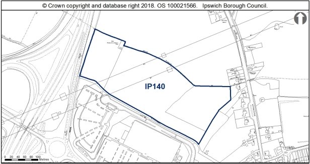
Allocation Policy SP5
|
Use(s) |
Indicative capacity |
|
|
Primary |
Employment Park Business (B1 including offices B1a) Other B class and appropriate employment-generating sui generis uses as defined through policy DM33 |
10,000 sq m 10,000 sq m |
Adopted Plan 2017
As above
Current use
Grassland.
Development constraints / issues
Access constraints and need to consider impacts on rights of way. Old Norwich Road/ Bury Road and Whitton Church Lane junctions both have contributions from the recent appeal site. It is likely that this site will need to contribute to a larger mitigation package for these junctions. Development will need to consider noise from the A14 and the need to support wildlife ecological network and recreational green corridor functions associated with the 'green trail' (see e.g. Core Strategy Policies CS16, DM8 and DM10). Detailed and up-to-date surveys are required for flora, bats, hazel dormouse, reptiles and amphibians, breeding birds and Priority species. The recommendations of the Ipswich Wildlife Audit 2019 could be incorporated into future development, unless other means of biodiversity enhancement are appropriate.
The site is adjacent to the Whitton Conservation Area. Any cumulative impacts on the conservation area with the development of sites IP005 and IP032 will need to be taken into account.
Roman, Medieval and Anglo-Saxon finds are recorded in the vicinity of the site area (IPS 093). The site has been subject to geophysical survey and trenching, which has confirmed that crop marks visible on it relate to Bronze Age and Iron Age archaeological remains in particular, including a settlement with some Roman activity. Conditions on any consent would be required to secure programmes of archaeological investigation, analysis, archiving and public dissemination of information. Suffolk County Council Archaeological Service can advise on the scope of works.
A comprehensive planning approach is required with land north of the site within Mid Suffolk District.
This site falls within the 91.4m height consultation zones surrounding Wattisham airfield, therefore any proposed structures which may exceed this height would need to be reviewed by the Ministry of Defence.
Surface water flooding local to site - will need to be considered at planning application stage. See Appendix 1 of the Ipswich SFRA.
A transport assessment and travel plan will be required.
A pipeline traverses the site. It could affect the layout or require diversion. National Grid will need to be consulted on any development proposals for the site.
This allocation site is located to the immediate west of the Whitton Conservation Area which includes numerous listed and non-designated heritage assets in the historic settlement of Whitton. The north of this allocation site marks the borough boundary with the neighbouring Mid Suffolk District Council. To the south of the allocation site is an existing retail park which is separated from this allocation site by a public right of way, and to the west is the A14.
Owing to the rural setting of the allocation site, a sympathetic design approach could be to look at clustering smaller units to provide a layout that might be expected on an agricultural holding, such as 1.5-2 storey 'U' shaped units around courtyards, with additional linear units. Materials such as traditional clay roof tiles, red brick and timber weatherboarding would soften the impact of the development of this site on the Whitton Conservation Area.
A development scheme would need to include a comprehensive landscaping strategy to help screen new development from Whitton Conservation Area, whilst also respond to the open landscape of the neighbouring Mid Suffolk District to the north.
(2) Site ref: IP141a (UC258) Land at Futura Park, Nacton Road (formerly the Cranes Site)
Site area: 4.78ha
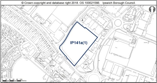
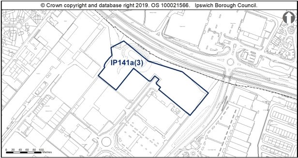
Allocation Policy SP5
|
Use(s) |
Indicative capacity |
|
|
Primary |
B-Class uses (excluding office use B1a) and appropriate employment-generating sui generis uses as defined through policy DM33 |
18,000 sq m |
Adopted Plan
As above, but third site IP141a(2) now removed
Current use
Vacant employment land (previously allocated as a strategic employment site).
Development constraints / issues
TPOs nearby fronting Nacton Road (an application for tree works may be required). Possible contamination. Adjacent to railway wildlife corridor and buffer. Surveys for reptiles, bats and detailed terrestrial invertebrate surveys are required. The recommendations of the Ipswich Wildlife Audit 2019 could be incorporated into future development, unless other means of biodiversity enhancement are appropriate.
The site is expected to require improvements to the existing water supply and foul sewerage networks to enable development.
The site is likely to require junction capacity enhancements from the A1189 / Nacton Road to A1156 Warren Heath junctions. A transport assessment and travel plan will be required.
These allocation sites are located on Futura Park, an out of town industrial/retail park to the south east of Ipswich. Recent development of Futura Park has been to a high architectural standard, with units generally being illustrative of quality design, using varied cladding systems, canopies, and fenestration. It is recommended that the design of new buildings continues this architectural precedent, and avoids utilitarian single volume warehousing.
Development along IP141a should address both Nacton Road and Crane Boulevard with active frontages, and avoid being set back from the highway by extensive car parking to allow for a greater street scene impact. Development along Nacton Road should include a landscape buffer to contribute to the leafy, suburban character of the area to the west.
(1) Site ref: IP149 (UC266) Pond Hall Farm
Site area: 24.7ha
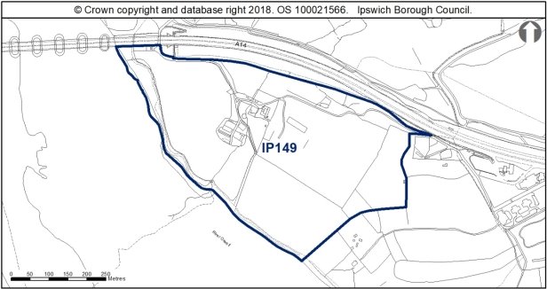
Allocation Policy SP8
|
Use(s) |
Indicative capacity |
|
Country Park extension |
- |
Adopted Plan 2017
As above
Current use
Farm land
Development constraints / issues
Access constraints, possible contamination, adjacent to a Ramsar Site and Special Protection Area for birds. The site would need to be master planned and measures put in place to manage public usage and link routes with neighbouring sites. The impacts of proposals on the SPA will be tested.
This land lies on a slope overlooking the Orwell Estuary, close to prehistoric sites and in a topographically favourable location in archaeological terms. Suffolk County Council Archaeology Service should be consulted up front on proposals for ground works or formal landscaping.
This site allocation for the extension of the Country Park includes the grade II listed Pond Hall, several historic outbuildings listed in curtilage to Pond Hall, and also some more modern structures associated with the former use of the site for farming. The hall itself is a rendered timber framed building which dates from at least the 16th century, and is a rare survival of a remote farmhouse within the borough which has retained its intended isolated setting.
Pond Hall is presently unoccupied, and the adjacent farm buildings are also vacant and are deteriorating in condition. A new use for Pond Hall and its associated outbuildings which would complement the Country Park extension would be encouraged, even if only an informal or infrequent use, such as a field study or visitors centre.
The use of this site for the Country Park extension should look to enhance the significance of Pond Hall, through removing the modern 20th century farm buildings located within the setting of the listed building, and allow for the farmstead to be interpreted as a historic cluster buildings which illustrate the expansion of the farm throughout the 19th century.
Pedestrian routes through the Country Park extension should look to guide public access across the Pond Hall site and its associated outbuildings, to encourage a level of natural surveillance of the buildings to protect these heritage assets from damage and decay which could arise from the isolated setting of these buildings.
The proposal should be supported by an ecological appraisal and detailed surveys including, but not confined to flora, breeding birds, overwintering birds, reptiles and bats and should encompass both the farmhouse and associated buildings and surrounding land.
(4) Site ref: IP150b (UC267 part) Land south of Ravenswood
Site area: 7.8ha
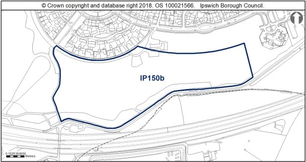
Allocation Policy SP7
|
Use(s) |
Indicative capacity |
|
Sports Park |
|
Adopted Plan 2017
As above on larger site.
Current use
Vacant land, informal open space.
Development constraints / issues
Access constraints – The site will need to be master planned comprehensively with the Ravenswood allocations IP150b through to IP150e and the Airport Farm Kennels site to the south to satisfactorily address potential significant impact on junctions which are already under strain and identify any junction (capacity) enhancements needed to avoid cumulative residual severe impact. Opportunities for sustainable access improvements should also be identified, and improvements to this part of the Nacton Road corridor between junction 57 and the Ransomes Way/Nacton Road junction to create an attractive gateway to Ipswich. It should link into cycling and pedestrian route networks. Possible drainage constraints.
The site has potential wildlife interest – ecological surveys including breeding birds, reptiles and invertebrates will be needed prior to any vegetation clearance, and mitigation where appropriate. To achieve biodiversity net gain, the recommendations of the Ipswich Wildlife Audit 2019 could be incorporated into future development, unless other means of biodiversity enhancement are appropriate. Also part of wildlife network and existing wildlife corridors should be safeguarded within future proposals.
The site is in close proximity to the Stour and Orwell SPA/ Ramsar site. Information to inform a project level HRA will be required to demonstrate that urbanisation impacts on the site are prevented.
This large site lies in the vicinity of Prehistoric remains and cropmarks, and as such any necessary mitigation measures for archaeology should be addressed at an appropriate stage in the planning process.
Surface water flooding local to site - will need to be considered at planning application stage. See Appendix 1 of the Ipswich SFRA.
A transport assessment and travel plan will be required.
Ravenswood has a distinctive spoke and wheel layout which allows for the residential development to blend comfortably into the heathy landscape of Ravenswood Park. The curved design of the estate acts as a soft edge to the development, leading to the rural edge of the borough. Introducing development which would reduce the distinctive legibility of Ravenswood and its relationship with this rural edge therefore requires careful consideration.
(2) Site ref: IP150c (UC267) Land south of Ravenswood
Site area: 1.18ha
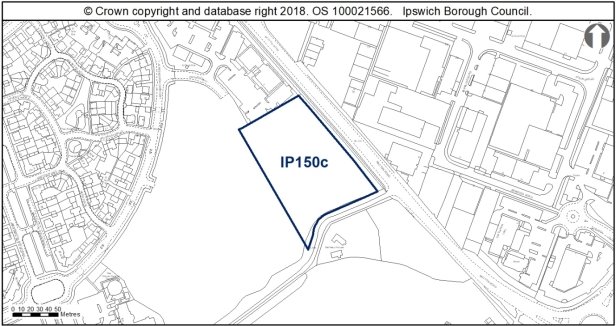
Allocation Policy SP5
|
Use(s) |
Indicative capacity |
|
|
Employment |
B1 uses (research & development, light industrial uses appropriate in a residential area, excluding office use B1a) and appropriate employment-generating sui generis uses as defined through policy DM33 (subject to policy DM18) |
11,000sqm |
Adopted Plan
20,000sqm of Employment on larger allocation.
Current use
Vacant land, informal open space.
Development constraints / issues
Access constraints – The site will need to be master planned comprehensively with the Ravenswood allocations IP150b through to IP150e and the Airport Farm Kennels site to the south to satisfactorily address potential significant impact on junctions which are already under strain and identify any junction (capacity) enhancements needed to avoid cumulative residual severe impact. Opportunities for sustainable access improvements should also be identified, and improvements to this part of the Nacton Road corridor between junction 57 and the Ransomes Way/Nacton Road junction to create an attractive gateway to Ipswich.
Drainage constraints. Surface water flooding local to site – will need to be considered at planning application stage. See Appendix 1 of the Ipswich SFRA. A transport assessment and travel plan will be required.
It should link into cycling and pedestrian route networks.
The site has potential wildlife interest – ecological, reptile and invertebrate surveys will be required prior to any vegetation clearance, and mitigation where appropriate. To achieve biodiversity net gain, the recommendations of the Ipswich Wildlife Audit 2019 could be incorporated into future development, unless other means of biodiversity enhancement are appropriate.
The site is in close proximity to the Stour and Orwell SPA/ Ramsar site. Information to inform a project level HRA will be required to demonstrate that urbanisation impacts on the site are prevented.
This site lies in the vicinity of Prehistoric remains and crop marks, and as such any necessary mitigation measures for archaeology should be addressed at an appropriate stage in the planning process.
Development proposals should look to address Nacton Road with an active frontage which makes a positive architectural statement to signal the entrance to the town from the east, and avoid a design and layout which turns its back to Nacton Road (like those to the north of the allocation site).
Proposals should also consider the relationship of the allocation site with IP150e, addressing any new residential development to the southwest with an engaging façade and landscaping.
(6) Site ref: IP150d (UC267) Land south of Ravenswood
Site area: 1.8ha
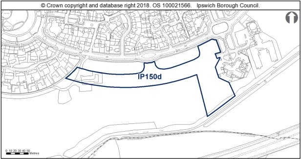
Allocation Policy SP2
|
Use(s) |
Indicative capacity |
|
|
Primary |
Residential |
34 (35dph on around 50% of site) |
* see Core Strategy policy DM23 for minimum and average densities.
Adopted Plan 2017
In adopted plan as the whole of IP150b allocated as sports park
Current use
Vacant land, informal open space.
Development constraints / issues
Access constraints – The site will need to be master planned comprehensively with the Ravenswood allocations IP150b through to IP150e and the Airport Farm Kennels site to the south to satisfactorily address potential significant impact on junctions which are already under strain and identify any junction (capacity) enhancements needed to avoid cumulative residual severe impact. Opportunities for sustainable access improvements should also be identified, and improvements to this part of the Nacton Road corridor between junction 57 and the Ransomes Way/Nacton Road junction to create an attractive gateway to Ipswich. Drainage constraints.
The site has potential wildlife interest – ecological, reptile and invertebrate surveys will be needed prior to any vegetation clearance, and mitigation where appropriate. To achieve biodiversity net gain, the recommendations of the Ipswich Wildlife Audit 2019 could be incorporated into future development, unless other means of biodiversity enhancement are appropriate. Also forms part of wildlife network.
The site is in close proximity to the Stour and Orwell SPA/ Ramsar site. Information to inform a project level HRA will be required to demonstrate that urbanisation impacts on the site are prevented.
Surface water flooding local to site – will need to be considered at planning application stage. See Appendix 1 of the Ipswich SFRA. A transport assessment and travel plan will be required.
It should link into cycling and pedestrian route networks.
This site lies in the vicinity of Prehistoric remains and crop marks, and as such any necessary mitigation measures for archaeology should be addressed at an appropriate stage in the planning process.
New residential development could occupy the arc to the south of Alnesbourne Close, mimicking the spoke and wheel layout of much of the Ravenswood estate. These units would need to be low density, one plot deep to reflect the character of the area.
Ravenswood features distinctive pockets of development, utilising varied architectural approaches and palette of materials which gives the estate an interesting character, such as dwellings along Downham Boulevard and Cranberry Square. This individual approach should be employed on this allocation site to provide a bespoke design which contributes to the character of Ravenswood and avoid replicating some of the plainer neo-Georgian design of Alnesbourne Close to the north.
(10) Site ref: IP150e (UC267) Land south of Ravenswood
Site area: 3.6ha
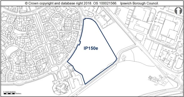
Allocation Policy SP2
|
Use(s) |
Indicative capacity |
|
|
Primary |
Residential |
126 (35dph on 100% of site) |
* see Core Strategy policy DM23 for minimum and average densities.
Adopted Plan 2017
Previously formed part of site IP150c which was allocated for employment.
Current use
Vacant land, informal open space.
Development constraints / issues
Access constraints – should be master planned comprehensively with the Airport Farm Kennels site to the south and improvements to this part of the Nacton Road corridor between junction 57 and the Ransomes Way/Nacton Road junction to create an attractive gateway to Ipswich.
Drainage constraints. Surface water flooding local to site – will need to be considered at planning application stage. See Appendix 1 of the Ipswich SFRA.
A transport assessment and travel plan will be required. It should link into cycling and pedestrian route networks.
The site has potential wildlife interest – ecological, reptile and invertebrate surveys will be required prior to any vegetation clearance, and mitigation where appropriate. To achieve biodiversity net gain, the recommendations of the Ipswich Wildlife Audit 2019 could be incorporated into future development, unless other means of biodiversity enhancement are appropriate. It also forms part of the wildlife network and existing wildlife corridors should be safeguarded within future proposals.
The site is in close proximity to the Stour and Orwell SPA/ Ramsar site. Information to inform a project level HRA will be required to demonstrate that urbanisation impacts on the site are prevented.
This site lies in the vicinity of Prehistoric remains and crop marks, and as such any necessary mitigation measures for archaeology should be addressed at an appropriate stage in the planning process.
Development should respect the architectural approaches and principles previously established at Ravenswood, with its distinctive spoke and wheel layout which provides long ranging sightlines along runways, illustrating the former airport use of the site.
Ravenswood features distinctive pockets of development, utilising varied architectural approaches and palette of materials which gives the estate an interesting character. This individual approach should be employed on this allocation site to provide a bespoke design which contributes to the character of Ravenswood and avoid replicating some of the plainer neo-Georgian design of Alnesbourne Close to the north.
Ravenswood benefits from several sculptures and public art commissions, which enhance the environment in which the estate is experienced, and responds to the high quality design and aspirations of the Ravenswood development. Development of this allocation site should look to introduce further public art to well designed and integrated public space to the allocation site.
(3) Site ref: IP152 (UC269) Airport Farm Kennels, north of the A14
Site area: 7.37ha
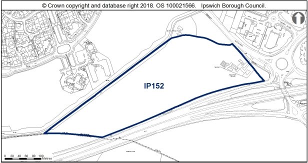
Allocation Policy SP5 & SP9
|
Use(s) |
Indicative capacity |
|
|
Primary |
B1, B2, B8 excluding B1a offices Appropriate employment-generating sui generis uses as defined through policy DM33 |
20,000sqm |
|
Secondary |
Feasibility of small section for Park & Ride to be explored |
|
Adopted Local Plan 2017
As above apart from park and ride. Park and ride was previously considered at this site through the First Deposit Draft Local Plan in 2001.
Current use
Farm land.
Development constraints / issues
Access constraints – should be master planned comprehensively with the Ravenswood site to the north (IP150e) and improvements to this part of the Nacton Road corridor between junction 57 and the Ransomes Way/Nacton Road junction to create an attractive gateway to Ipswich. A transport assessment and travel plan would be a requirement for any future planning application to clarify and address highway issues.
Possible area of archaeological importance, possible contamination, TPO on site or nearby, Area of Outstanding Natural Beauty on part and noise from the A14. Development will be subject to the preparation of a development brief, which will be expected to address a range of matters including impact on landscape and the purpose of conserving and enhancing the natural beauty of the Area of Outstanding Natural Beauty.
The site has potential wildlife interest – an ecological appraisal and detailed surveys for bats, badgers, invertebrates, breeding birds and reptiles will be required prior to any vegetation clearance, and mitigation where appropriate. Mature oaks and hedges should be retained. New development should retain as much of the existing habitat as possible and integrate it within a landscaping scheme, in particular the hedgerows and mature trees along the boundaries. To achieve biodiversity net gain, the recommendations of the Ipswich Wildlife Audit 2019 could be incorporated into future development, unless other means of biodiversity enhancement are appropriate.
The site is in close proximity to the Stour and Orwell SPA/ Ramsar site. Information to inform a project level HRA will be required to demonstrate that urbanisation impacts on the site are prevented.
This site includes a known Bronze Age barrow (IPS 027). This indicates that there are other prehistoric archaeological remains of high importance in the vicinity. As such any necessary mitigation measures for archaeology should be addressed at an appropriate stage in the planning process, ahead of submitting any planning application.
Water infrastructure and/or treatment upgrades will be required to serve the proposed growth or diversion of assets may be required.
This allocation site is located to the south of Ravenswood and north of the A14. The site wraps around Halfway House, one of few remaining buildings in the South East Urban Character Area which pre-date the 20th century.
This site is bounded to the north by trees which are covered by TPOs, as well as further TPOs within the site, which will need to be considered in development proposals.
Proposals for a park and ride would need to include extensive landscaping to soften the impact of extensive hardstanding associated with car parking and bus terminals, perhaps laid out in concentric rings rather than a grid, to reflect the spoke and wheel character of the southeast of the town (seen at Ravenswood and the Nacton estate).
B1, B2 and B8 development should be well designed and make a positive architectural statement, as they are likely to the first buildings users of the Park and Ride will see when entering Ipswich from the east. Development should respect the adjacent Halfway House, and should have a layout which allows for a buffer between this existing dwellinghouse and new development.
Site ref: IP172 (UC088) 15-19 St Margaret's Green
Site area: 0.08ha
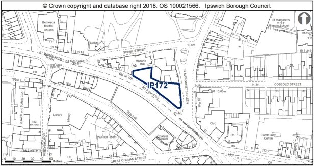
Allocation Policy SP2
|
Use(s) |
Indicative capacity |
|
Residential |
9 (110dph) |
* see Core Strategy policy DM23 for minimum and average densities.
Adopted Plan 2017
As above
Current use
Vacant land.
Development constraints / issues
Previous permissions have not been implemented (for flats and student accommodation). The site is below the threshold size for allocation but because of its prominent location, it is considered appropriate to plan positively for the site. It is within an Air Quality Management Area and may have possible contamination. The site is within the Central Conservation Area, with a nearby scheduled monument, and adjacent listed buildings.
This part of town lies outside the Late Saxon defences, but was part of the Middle Anglo-Saxon town and is within the Area of Archaeological Importance (IPS 413) and close to a scheduled monument (NHLE 1005989). Detailed early pre-application discussions with Suffolk County Council Archaeological Service would be required to agree the scope of required assessment and to inform design (e.g. to allow for preservation in-situ of deposits or appropriate programmes of work). Archaeological remains may be complex and important and mitigation could involve significant costs and timescales.
This allocation site is located within the Central Conservation Area and within the setting of numerous listed buildings, and occupies a prominent corner position on St Margaret's Green with considerable street scene potential. Development of this allocation site therefore has the potential to affect the setting of a number of designated heritage assets, as well as the character and appearance of the Conservation Area.
Development should reflect the surrounding 2.5-3 storey scale of historic buildings, and should provide an active frontage which engages with both St Margaret's Green and St Margaret's Street, with a distinctive design which turns the corner of the junction to provide a well-designed, landmark building.
Development should interpret adjacent architectural influences and materials to provide a contemporary proposal which responds to the historic setting of the allocation site.
Site ref: IP188 (N/A) Webster's Saleyard Site, Dock Street
Site area: 0.11ha
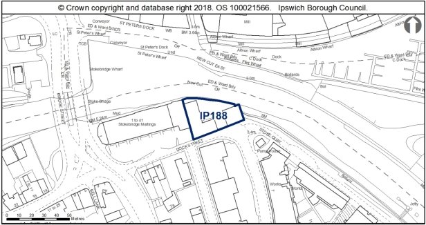
Allocation Policy SP2
|
Use(s) |
Indicative capacity |
|
Residential |
9 (as per approved permission 19/00173/FUL) |
Adopted Plan 2017
As above
Current use
Vacant site. Planning permission for 9 flats.
Development constraints / issues
Contamination and flood risk. The site is within the Stoke Conservation Area, with an adjacent listed building. The conservation area is currently on the Heritage at Risk Register.
There is an aspiration for a cycle and pedestrian crossing to St Peter's Quay/ the Island Site immediately to the east of this site (policy SP15). To enable greater recreational, leisure and sports use of the Gipping and Orwell rivers, provision of Upper River Orwell (tidal) slipway or pontoon access and facilities including boat storage facilities should be considered.
Development would need to address the river frontage and support the wildlife corridor function of the river. Development principles for the Island Site Opportunity Area, within which the site is located, are set out in Chapter 6 of the Site Allocations and Policies plan (see 'Opportunity Area A').
This site lies immediately adjacent to an area of Middle Saxon activity and routes leading to the river, and within the Area of Archaeological Importance (IPS413). Detailed early pre-application discussions with Suffolk County Council Archaeological Service would be required to agree the scope of required assessment and to inform design (e.g. to allow for preservation in-situ of deposits or appropriate programmes of work). Archaeological remains may be complex and important and mitigation could involve significant costs and timescales.
Surface water flooding local to site - will need to be considered at planning application stage. See Appendix 1 of the Ipswich SFRA.
Development must take account of the River Corridor Buffer (10m) where no development should take place, where practicable.
The buildings should be assessed for their bat potential prior to any demolition.
Site ref: IP221 (N/A) The Flying Horse PH, 4 Waterford Road
Site area: 0.35ha
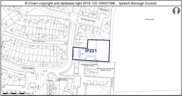
Allocation Policy SP2
|
Use(s) |
Indicative capacity |
|
Residential (retaining the public house) |
12 (35dph*) |
* see Core Strategy policy DM23 for minimum and average densities.
Adopted Plan 2017
12 dwellings at 35dph
Current use
Pub and vacant land.
Development constraints / issues
Previous planning permission for 12 dwellings lapsed.
Possible access constraints, TPO on site or nearby.
This site falls within the 91.4m height consultation zones surrounding Wattisham airfield, therefore any proposed structures which may exceed this height would need to be reviewed by the Ministry of Defence.
This allocation site includes an existing public house and associated backland which is bounded by residential gardens to the north, playing fields to the east, and a school to the south. This site is located within a mid-20th century housing estate, the character of which is suburban with wide roads, verges and pavements; two-storey semi-detached or short terraces in brown brick with concrete tiled or pantiled roofs. The allocation site includes a willow tree which is the subject of a TPO.
Development of this allocation site should be of a distinctive design, bespoke to this backland plot which provides an interesting design which is visible in views from Waterford Road. Alterations to the public house are likely to be required to provide access to the site. This should look to enhance the appearance of the public house, whilst still respecting the mid-20th character of the building.
Further surveys should be undertaken for reptiles to inform a mitigation strategy, as slow worm is known to be on site. Consideration should also be given to the likely impact of vegetation clearance upon the local hedgehog population and ideally some of the scrub should be retained to preserve the local opportunities for hibernation. As this site is located adjacent to existing open space which in turn links to the wider ecological network, there is an opportunity to strengthen the local ecological network by retention and enhancement of onsite habitats adjacent to this feature. The recommendations of the Ipswich Wildlife Audit 2019 could be incorporated into future development, unless other means of biodiversity enhancement are appropriate.
(1) Site Ref: IP279a, b(1) and b(2) – Former British Telecom Office, Bibb Way
Site area: IP279a 0.63ha, IP279b(1) 0.44ha and IP279b(2) 0.61ha
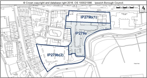
Allocation Policy SP2, SP3
|
|
Use(s) |
Indicative capacity |
|
IP279b(1) |
Residential |
18 (based on masterplanning work with IP279a and IP279b(2)) |
|
IP279b(2) |
Residential |
29 (based on masterplanning work with IP279a and IP279b(1)) |
|
IP279a |
Residential (SP3 – Land with planning permission) |
104 (18/00470/P3JPA) |
Adopted Plan 2017
N/A – New site
Current use
Mostly vacant offices and associated car parking. Prior approval granted on offices for 104 dwellings.
Development constraints / issues
The IP279 site has been split into three sites to reflect the approval of the recent prior approval (18/00470/P3JPA). As the two remaining parcels of land (IP279b(1) and IP279b(2)) are physically separated by the prior approval, they have been sub-divided into two separate sites. The capacities indicated have been formulated on the basis of early masterplanning discussions with the site owner.
Development principles for the Upper Orwell River and Canalside within which the site is located, are set out in Chapter 6 of the Site Allocations and Policies Plan (See 'Opportunity Area G'). These include development addressing the canal frontage appropriately, and providing public cycle and pedestrian access through from Bibb Way to Handford Road.
Part of this site may be contaminated and a contaminated land assessment may be required.
Archaeological sites with remains relating to Prehistoric, Anglo-Saxon and the Roman periods in particular have been excavated in the vicinity of the development site, relating to activity on the higher ground over the town marsh and towards Handford Bridge. Further towards the marsh, deposits may have potential for organic and palaeo-environmental remains. Detailed early pre-application discussions with Suffolk County Council Archaeological Service would be required to agree the scope of required assessment and to inform design (e.g. to allow for preservation in-situ of deposits or appropriate programmes of work). Archaeological remains that may survive may be complex and important, with attendant costs and timescales.
Water infrastructure and/or treatment upgrades may be required to serve the proposed growth, or diversion of assets may be required.
Surface water flooding local to site - will need to be considered at planning application stage. See Appendix 1 of the Ipswich SFRA.
A transport assessment and travel plan will be required.
County Wildlife Site and Local Nature Reserve adjacent to the site. The site may have wildlife interest an ecological and reptile survey will be needed. Development of this site should ensure that the Alderman Canal corridor and its associated habitats are buffered and enhanced. Any future green space should be sited adjacent to the canal, to complement it and the design and layout would need to support the wildlife corridor function. To achieve biodiversity net gain, the recommendations of the Ipswich Wildlife Audit 2019 could be incorporated into future development, unless other means of biodiversity enhancement are appropriate.
This site contains cotoneaster and members of this group are listed on Schedule 9 of the Wildlife & Countryside Act 1981, as amended, because they can become dominant to the detriment of other species. As such, it is an offence to plant or otherwise cause these species to grow in the wild. If this plant is removed as part of a vegetation clearance programme then it should be disposed of in a way as not to contravene the legislation.
Development of IP279b(2) must take account of the River Corridor Buffer (10m) where no development should take place. Development of IP279b(2) must also include pedestrian/ cycle access along the river to allow for a continuous route to connect to site allocation IP355.
This allocation site is located to the south of the Burlington Road Conservation Area opposite an area of 19th century dwellinghouses. The site is bounded to the south by the River Gipping, and the far west by early 20th century terraced housing. The site was once occupied by Handford Hall, a large detached residence which fronted onto Handford Road situated in large grounds which included a boat house and lake.
New development should respect the 2-3 storey domestic scale of adjacent buildings, and provide an active frontage onto Handford Road creating a positive architectural statement upon the entrance to the site. Proposals should also address the southern boundary which looks onto the River Gipping, and will be visible in views from the river walk.
A contemporary architectural approach would be encouraged, considering adjacent architectural influences to inform a modern development proposal, maximising views southwards over the river and recreation ground.
Development of this site should improve both pedestrian and vehicular access between Handford Road and Portman's Walk along Bibb Way to improve permeability through the town.
(6) Site Ref: IP307 – Princes of Wales Drive
Site Area: 0.27ha
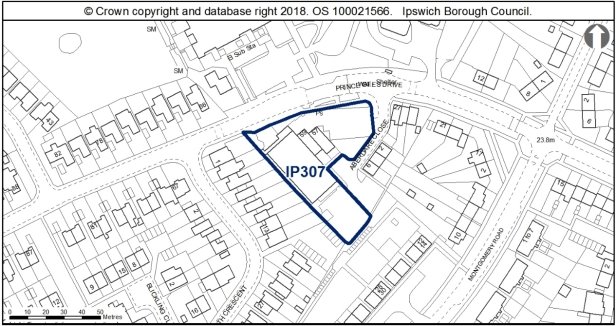
Allocation Policy SP2
|
Use(s) |
|
Indicative capacity |
|
Primary |
Residential |
12 (45dph) |
* see Core Strategy policy DM23 for minimum and average densities.
Adopted Plan 2017
A designated local centre under DM24. New site for residential.
Current use
Retail units – Partially vacant
Development constraints / issues
A transport assessment and travel plan may be required.
When approaching the allocation site from the west, the existing dwellinghouses on the north side of Prince of Wales Drive are characterised by distinctive monopitched roofs, whilst adjacent on Chatsworth Drive is an unusual design of two storey dwellinghouses with pitched roofs with single storey side ranges which link the houses together at first floor. The architecture surrounding the allocation site therefore includes some attempts at producing distinctive and varied designs. This innovative approach to architectural design would be encouraged in the development of this allocation site.
The position of this allocation site on the curve of Prince of Wales Road opposite Halifax Primary School as land drops away to the east does provide the site with opportunity to provide a more distinctive, landmark scheme, which would contribute to the varied architectural character of the area.
Across the site looking southeast are views over the estuary and of the Orwell Bridge. Views out of the borough across the surrounding landscape are identified in the Chanty, Stoke Park and Maidenhall Ipswich Urban Characterisation Study as being significant to this area. Although these are views which can only currently be glimpsed, the creation of new sightlines across the estuary would be encouraged to be incorporated in the development of this site.
To achieve biodiversity net gain, the recommendations of the Ipswich Wildlife Audit 2019 could be incorporated into future development, unless other means of biodiversity enhancement are appropriate.
(1) Site Ref: IP309 - Former Bridgeward Social Club, 68a Austin Street
Site Area: 0.28
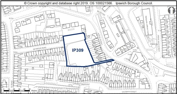
Allocation Policy SP2
|
Use(s) |
|
Indicative capacity |
|
Primary |
Residential |
15 (54dph Higher end based on proximity to local centre) |
* see Core Strategy policy DM23 for minimum and average densities.
Adopted Plan 2017
N/A – New Site.
Current use
Vacant social club.
Development constraints / issues
A transport assessment likely to be required. Access constraints onto Austin Street.
The wildlife interest of this site is improving as time progresses. Prior to any development a Preliminary Ecological Appraisal should be undertaken alongside any specific detailed surveys recommended in that report which may include, but not be limited to, botanical, reptiles and invertebrates. Due to the nature of the site, the report should also include the potential for invasive species. The recommendations of the Ipswich Wildlife Audit 2019 could be incorporated into future development, unless other means of biodiversity enhancement are appropriate.
Site ref: IP347 – Mecca Bingo
Site area: 0.12ha
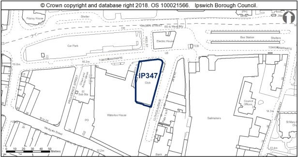
Allocation Policy SP10
|
Use(s) |
Indicative capacity |
|
|
Primary |
Retail – A1 |
650sqm |
|
Secondary |
Bingo |
- |
Adopted Plan 2017
N/A – new site
Current use
D2 Bingo Hall
Development constraints / issues
Within the Area of Archaeological Importance, adjacent to Central Conservation Area.
This allocation site is occupied by the Odeon Cinema, erected in 1936, although currently in use as a bingo hall. The building is of the art deco era, with 'faience' ceramic cladding, pilasters, decorative urns, and red brickwork. The former use as a cinema is evident through the limited fenestration along the façade of the building.
Elevated on high ground atop Lloyds Avenue, the hall is a dominant building in the streetscape, which contributes positively to the character of the Central Conservation Area and adjacent early 20th century buildings.
The use of this allocation site should respect the art deco design of the building, and avoid alterations which would erode the building's appearance as a 1930s cinema, which is of historic and townscape interest.
Site ref: IP348 – Upper Princes Street
Site area: 0.53ha
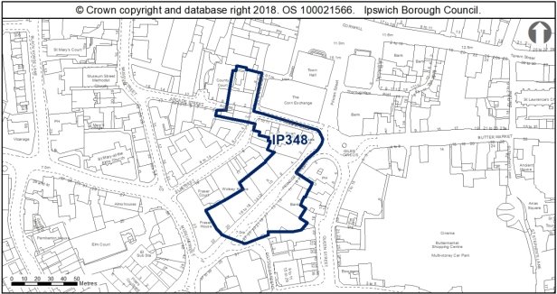
Allocation Policy SP10
|
Use(s) |
Indicative capacity |
|
|
Primary |
Retail – A1 |
400sqm |
Adopted Plan 2017
N/A – new site
Current use
A2 Banks and professional services, some vacant units
Development constraints / issues
The site is located in the Central Conservation Area and adjacent to a number of Listed Buildings
Also within an Area of Archaeological Importance.
The allocation encourages the change of use of existing A2 units to A1.
This allocation site is located within the Central Conservation Area, and includes numerous listed buildings, many of which already have uses which are appropriate and sympathetic to these historic buildings.
These buildings are an important approach to the town centre when approaching from the south, and so uses should make a positive statement upon the entrance to the town, reuse historic shop fronts, and look for opportunities to enhance the Conservation Area with regard to modern shop fronts and signage.
(6) Site Ref: IP354 – 72 (Old Boatyard) Cullingham Road
Site Area: 0.34

Allocation Policy SP2
|
Use(s) |
|
Indicative capacity |
|
Primary |
Residential |
24 (70dph. Less than 90dph due to site constraints and pre-application feedback) |
* see Core Strategy policy DM23 for minimum and average densities.
Adopted Plan 2017
N/A – New Site.
Current use
Boatyard.
Development constraints / issues
In Flood Zones 2 and 3.
Possible contamination from former use of site.
River Wildlife Corridor immediately adjacent and site within buffer zone.
Development must take account of the River Corridor Buffer (10m) where no development should take place.
In IP-One Opportunity Area G.
(2) Site Ref: IP355 – 77-79 Cullingham Road
Site Area: 0.06ha
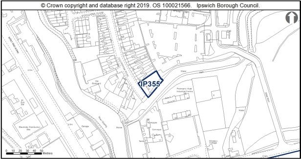
Allocation Policy SP2
|
Use(s) |
|
Indicative capacity |
|
Primary |
Residential |
6 (100dph based on location in Portman Quarter) |
* see Core Strategy policy DM23 for minimum and average densities.
Adopted Plan 2017
N/A – New Site.
Current use
Light industrial unit.
Development constraints / issues
In Flood Zones 2 and 3.
Possible contamination from former use of site.
River Wildlife Corridor immediately adjacent and site within buffer zone.
Development must take account of the River Corridor Buffer (10m) where no development should take place.
In IP-One Opportunity Area G.
Development must safeguard capacity for a footpath and cycle path through the site to connect Cullingham Road with Bibb Way.
(7) Site Ref: ISPA 4.1 – Northern End of Humber Doucy Lane
Site Area: 23.62ha (within IBC Land)
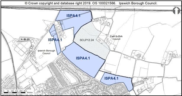
Allocation Policy SP2 & ISPA4
|
Use(s) |
|
Indicative capacity |
|
Primary |
Residential |
496 (35dph on circa 60% of site) |
|
Secondary |
Green Rim Trail Highways Improvements Early Years Setting Sports Pitches Suitable Accessible Natural Green Space (SANGS) Associated Infrastructure |
Approximately 40% of site |
Adopted Plan 2017
N/A – New Site. Previously allocated as Countryside.
Current use
Predominantly greenfield arable land.
Development constraints / issues
The principles and requirements set out in policy ISPA4 of the Core Strategy and Development Management Policies DPD must be followed.
The development of this land will need to be masterplanned along with the adjacent land allocated under the Suffolk Coastal Local Plan Review Policy SCLP12.24.
Development will need to be phased and delivered in coordination with the delivery of the Ipswich Garden Suburb to ensure that there is sufficient infrastructure capacity to meet demand.
An Early Years setting and replacement sports facilities, if needed, will need to be incorporated into any future development. Development will need to make appropriate provision towards primary school places which are likely to be accommodated within the three new primary schools planned through the Ipswich Garden Suburb.
The layout and design of any future development must incorporate the provision of a Green Trail walking and cycling route to help deliver the wider Green Trail around Ipswich. The provision of Suitable Accessible Natural Green Space and other forms of open space will be required in accordance with the Open Space Standards set out in Appendix 5 of the Core Strategy and Development Management Policies DPD.
Highways and junction improvement works along Humber Doucy Lane are likely to be required. A transport assessment and travel plan will be required to ensure that development contributes towards delivering a significant modal shift to sustainable transport modes.
A high-quality of design will be required which also respects the countryside setting around the site. Biodiversity will need to be preserved and must incorporate net gain. The Ipswich Wildlife Audit 2019[8] provides further information on ecological surveys that will be required, as well as recommendations for how biodiversity net gain can be incorporated into new development, unless other means of biodiversity enhancement are appropriate. There are rows of Tree Preservation Orders (TPOs) along the boundary with Westerfield House that will need to be preserved unless there are overriding reasons for their removal. Where possible existing hedges onto Humber Doucy Lane shall be preserved and protected during the development process as applicable.
The setting of the grade II Listed Westerfield House Hotel must be preserved and enhanced as part of any future development of the site. The development should also seek to preserve the significance of the Listed Buildings to the north and east of the site. These are Allens House, Laceys Farmhouse, and the Garden Store north of Villa Farmhouse.
[8] See Wildlife Audit Site Sheets for IP184a, IP184c, IP303, IP309, IP344 and IP350