Draft Site Allocations and Policies (incorporating IP-One Area Action Plan) Development Plan Document
Appendix 3
Site Allocation Details
Site ref: IP004 (UC004) Sir Alf Ramsey Way / West End Road
Site area: 1.07ha
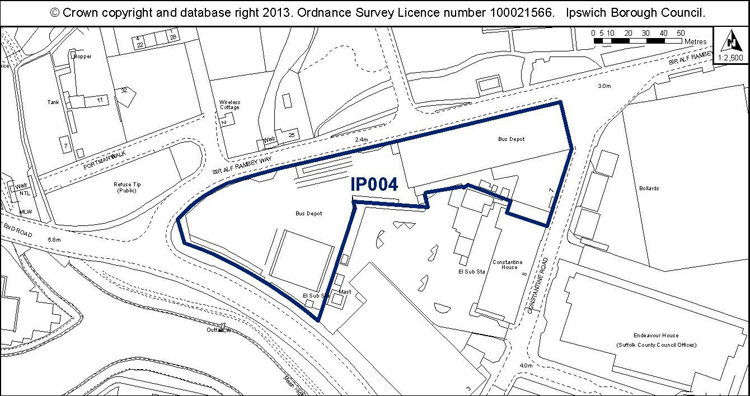
Proposed Allocation Policy DM39 & DM42
|
Use(s) |
% of site |
Density of housing (H, M, L)* |
Indicative capacity |
|
Housing Employment (B1 office) |
50% 50% |
H |
59 |
* see Core Strategy policy DM30 for average densities.
Preferred Option 2007
50% housing at high density – 88 dwellings
50% B1 employment
Current use
Ipswich Buses bus depot
Development constraints / issues
Need to relocate the bus station first.
Development is required to retain the tram shed with the expectation that it would be converted for office use. The tram shed is included on the Local List of buildings of townscape interest.
Flood risk and possible contamination are further constraints.
(1) Site ref: IP005 (UC005) Former Tooks Bakery, Old Norwich Road
Site area: 2.8ha
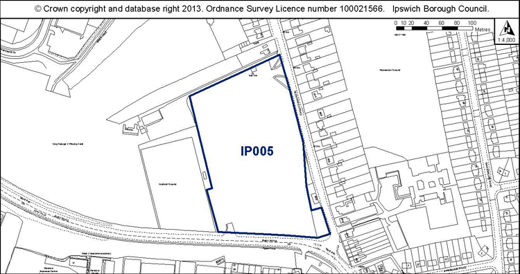
Proposed Allocation Policies DM39 & DM44
|
Use(s) |
% of site |
Density of housing (H, M, L)* |
Indicative capacity |
|
Housing New health centre |
80% c. 20% |
M |
101 |
* see Core Strategy policy DM30 for average densities.
Preferred Option 2007
80% housing at medium density – 122 dwellings
20% community facilities
Current use
Vacant site / external storage
Development constraints / issues
Development needs to include a doctor’s surgery.
Access constraints and possible contamination. It is adjacent to a conservation area.
(1) Site ref: IP006 (UC006) Coop Warehouse, Paul’s Road
Site area: 0.63ha
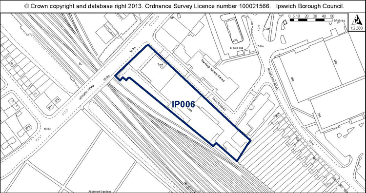
Proposed Allocation Policy DM39
|
Use(s) |
% of site |
Density of housing (H, M, L)* |
Indicative capacity |
|
Housing |
100% |
M |
28 |
* see Core Strategy policy DM30 for average densities.
Preferred Option 2007
80% housing at low density – 17 dwellings
20% employment
Current use
Co-Op warehouse and printing works.
Development constraints / issues
Need to relocate remaining warehousing activities and active businesses at the south-eastern end of the site. Conversion of the warehouse building would be encouraged.
Possible contamination and noise from the railway line.
Site ref: IP009 (UC009) Victoria Nurseries, Westerfield Road
Site area: 0.39ha
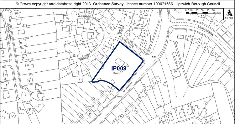
Proposed Allocation Policy DM39
|
Use(s) |
% of site |
Density of housing (H, M, L)* |
Indicative capacity |
|
Housing |
100% |
L |
14 |
* see Core Strategy policy DM30 for average densities.
Preferred Option 2007
100% housing at low density – 14 dwellings
Current use
Plant nursery and small convenience shop
Development constraints / issues
Possible contamination and a TPO on site or adjacent.
Site ref: IP010a (UC010) Co-Op Depot Felixstowe Road
Site area: 2.73ha
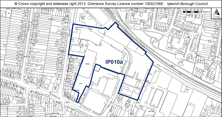
Proposed Allocation Policies DM39 & DM44
|
Use(s) |
% of site |
Density of housing (H, M, L)* |
Indicative capacity |
|
Housing Extension to Rose Hill School |
80% 20% |
M |
98 |
* see Core Strategy policy DM30 for average densities.
Preferred Option 2007 For the whole of site UC010 which now equates to IP010a and IP010b:
80% housing at medium density – 227 dwellings
20% Education and Community Facilities
Current use
Vacant or part used yards and employment premises. Note that the site now excludes the Aldi and Coop stores.
Development constraints / issues
Expansion needed at Rose Hill School.
Possible contamination, TPO on site or nearby, noise from the railway. Design and layout would need to support the wildlife corridor function of the railway.
Site ref: IP010b (UC010) Felixstowe Road
Site area: 2.79ha
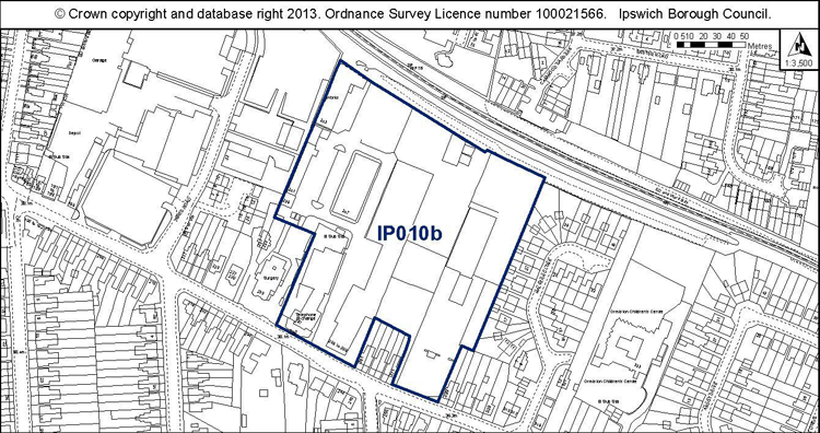
Proposed Allocation Policy DM39
|
Use(s) |
% of site |
Density of housing (H, M, L)* |
Indicative capacity |
|
Housing (current uses retained on remainder) |
60% |
M |
75 |
* see Core Strategy policy DM30 for average densities.
Preferred Option 2007 For the whole of site UC010 which now equates to IP010a and IP010b:
80% housing at medium density – 227 dwellings
20% Education and Community Facilities
Current use
Various employment uses and multiple occupiers
Development constraints / issues
Redevelopment is dependent on existing uses being relocated.
Possible contamination, TPO on site or nearby, noise from the railway. Design and layout would need to support the wildlife corridor function of the railway.
Site ref: IP011b (UC011) Smart Street / Foundation Street
Site area: 0.69ha
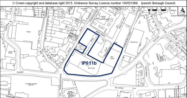
Proposed Allocation Policy DM39 & DM42
|
Use(s) |
% of site |
Density of housing (H, M, L)* |
Indicative capacity |
|
Housing Employment (B1 office) |
80% 20% |
H |
61 |
* see Core Strategy policy DM30 for average densities.
Preferred Option 2007
80% housing at high density – 112 dwellings (on larger site including former Gym and Trim)
20% B1 employment
Current use
First bus depot and vacant land.
Development constraints / issues
Bus depot needs to be relocated before development could commence.
Air quality, flood risk, possible contamination, possible access constraints, TPO on site or nearby. Development principles for the Merchant Quarter, within which the site is located, are set out in Chapter 7 of the Site Allocations and Policies plan (see ‘Opportunity Area B’).
Site ref: IP012 (UC012) Peter’s Ice Cream
Site area: 0.32ha

Proposed Allocation Policy DM39
|
Use(s) |
% of site |
Density of housing (H, M, L)* |
Indicative capacity |
|
Housing |
100% |
H |
35 |
* see Core Strategy policy DM30 for average densities.
Preferred Option 2007
100% housing at high density – 53 dwellings
Current use
Former ice cream factory and engineering works.
Development constraints / issues
Planning permission granted for student accommodation subject to a planning agreement (08/00978), however it is considered unlikely to come forward for this use.
Possible access constraints, close to an Air Quality Management Area, in an area of archaeological importance and there is possible contamination.
Site ref: IP015 (UC015) West End Road Surface Car Park
Site area: 1.22ha
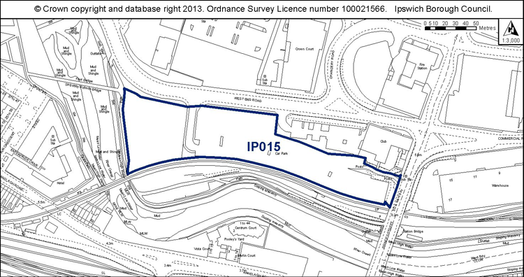
Proposed Allocation Policies DM39, DM42 & DM57
|
Use(s) |
% of site |
Density of housing (H, M, L)* |
Indicative capacity |
|
Housing Employment (B1 office) Long stay car parking |
20% 10% 70% |
H |
27 |
* see Core Strategy policy DM30 for average densities.
Preferred Option 2007
20% housing at high density – 40 dwellings
10% B1 employment 70% Multi storey car park
Current use
Surface level long stay car parking.
Development constraints / issues
Existing car parking needs to be replaced on site and potentially that from Portman Road also. The site should be master planned with the adjacent site to the south, fronting the river (IP083). Flood risk, possible contamination and adjacent to a listed building. Development principles for the River Corridor and Princes Street Corridor, within which the site is located, are set out in Chapter 7 of the Site Allocations and Policies plan (see ‘Opportunity Area F’).
Site ref: IP029 (UC030) Land Opposite 674-734 Bramford Road
Site area: 2.26ha
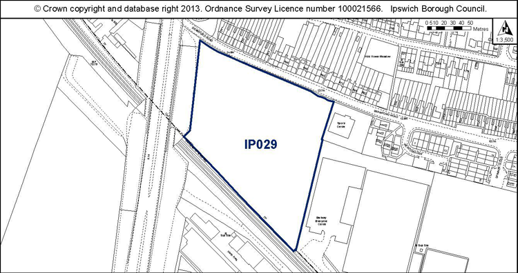
Proposed Allocation Policies DM39 & DM43
|
Use(s) |
% of site |
Density of housing (H, M, L)* |
Indicative capacity |
|
Housing Open space |
70% 30% |
M |
71 |
* see Core Strategy policy DM30 for average densities.
Preferred Option 2007
50% housing at medium density – 85 dwellings
50% Open Space
Current use
Vacant land used informally for recreation. Part used at present in connection with Chord works.
Development constraints / issues
Completion of Chord works. Loss of informal open space, although it was not identified as recreational open space in the Open Space, Sport and Recreation Study 2009 or the 1997 Ipswich Local Plan. Access constraints, possible contamination, noise from the A14 and railway. The site has potential wildlife interest – a reptile survey will be needed prior to any vegetation clearance, and mitigation where appropriate. Please refer to the Ipswich Wildlife Audit 2012. Design and layout would need to support the wildlife corridor function of the railway and A14.
Site ref: IP031 (UC032) Burrell Road
Site area: 0.44ha
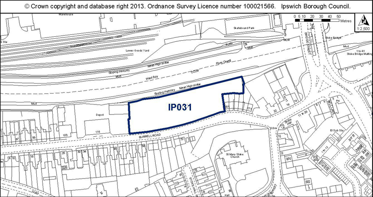
Proposed Allocation Policy DM39
|
Use(s) |
% of site |
Density of housing (H, M, L)* |
Indicative capacity |
|
Housing |
100% |
M |
20 |
* see Core Strategy policy DM30 for average densities.
Preferred Option 2007
100% housing at high density on a larger site of 0.74ha – 122 dwellings
Current use
Car park.
Development constraints / issues
In a flood zone, close to an AQMA, adjacent to a conservation area, part within area of archaeological importance, possible contamination. Development would need to support the wildlife corridor function of the river.
Site ref: IP032 (UC033) King George V Field, Old Norwich Road
Site area: 3.54ha
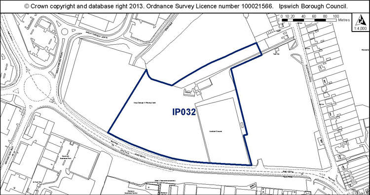
Proposed Allocation Policies DM39 & DM43
|
Use(s) |
% of site |
Density of housing (H, M, L)* |
Indicative capacity |
|
Housing Open space |
80% 20% |
L |
99 |
* see Core Strategy policy DM30 for average densities.
Preferred Option 2007
50% housing at medium density – 97 dwellings
50% Open space
Current use
Playing fields
Development constraints / issues
Need prior provision of a replacement pitch in the locality. However more (80%) of the site can now be redeveloped than previously thought (50%) because the open space to the north of the site is being retained. Possible access constraints, adjacent to a conservation area, possible contamination. Trees on southern boundary protected by a TPO.
Site ref: IP033 (UC034) Land at Bramford Road (Stock’s site)
Site area: 2.03ha
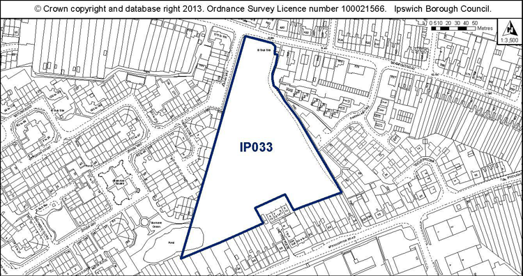
Proposed Allocation Policies DM39 & DM43
|
Use(s) |
% of site |
Density of housing (H, M, L)* |
Indicative capacity |
|
Housing Open space |
50% 50% |
M |
46 |
* see Core Strategy policy DM30 for average densities.
Preferred Option 2007
20% housing at medium density – 22 dwellings
80% Open space
Current use
Open land (fenced).
Development constraints / issues
Possible access constraints, possible contamination (former landfill), local wildlife site. A reptile survey will be needed prior to any vegetation clearance, and mitigation where appropriate. Development should retain a thick, scrubby buffer around the pond. Please refer to the Ipswich Wildlife Audit 2012.
Site ref: IP035 (UC036) Key Street / Star Lane / Burtons Site
Site area: 0.54ha
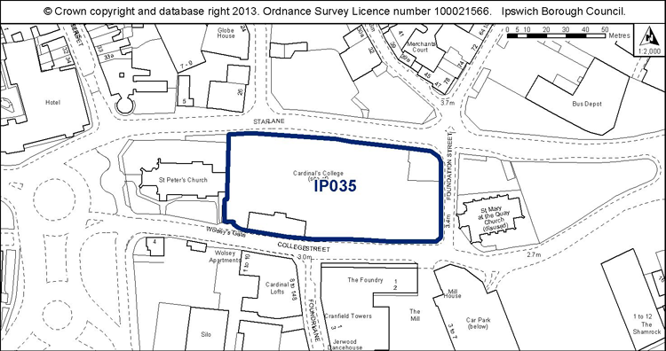
Proposed Allocation Policy DM42
|
Use(s) |
% of site |
Density of housing (H, M, L)* |
Indicative capacity |
|
B1 Office Employment Hotel / leisure Small scale retail Car parking |
c. 40% c. 40% c. 10% c. 10% |
N/A |
N/A |
Preferred Option 2007
30% B1 employment; 50% hotel; 10% small scale retailing or food and drink; 10% car parking
Current use
Vacant land.
Development constraints / issues
Access constraints, within an Air Quality Management Area, an area of archaeological importance and a conservation area, possible contamination, in a flood zone and listed buildings on or adjacent to the site.
(2) Site ref: IP037 (UC038) Island Site
Site area: 6.02ha
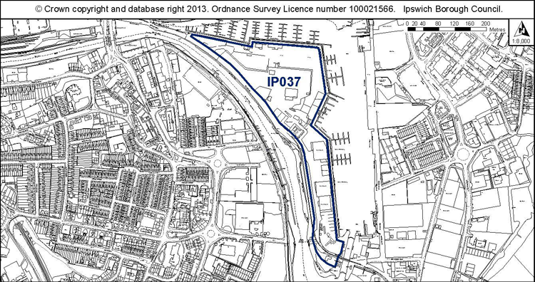
Proposed Allocation Policies DM39, DM42 & DM43
|
Use(s) |
% of site |
Density of housing (H, M, L)* |
Indicative capacity |
|
Housing B1 Employment and leisure Open space Small scale retail/café/ restaurant |
50% 30% 15% 5% |
H lower end of range |
271 |
* see Core Strategy policy DM30 for average densities.
Preferred Option 2007
50% housing at high density – 497 dwellings
30% Employment and leisure
15% Open space
5% Small scale retail/café/ restaurant
Current use
Mix of uses – boat building, fitting and servicing, pub/restaurant, industrial uses.
Development constraints / issues
Redevelopment will be dependent on the intentions of existing businesses. The aim would be retain and incorporate the existing boat-related uses and leisure uses. Development would require the provision of additional vehicular and pedestrian/cycle access (see Policy DM45).
It is close to an AQMA, in an area of archaeological importance, in a conservation area, in a flood zone, and close to the Orwell Estuary Special Protection Area.
Development principles for the Island Site are set out in Chapter 7 of the Site Allocations and Policies plan (see ‘Opportunity Area A’). They include, for example, retaining and refurbishing historic structures such as the local keeper’s cottages and harbour master’s house. The site will need to be master planned given its importance, and the master plan will need to address the development principles set out in the plan.
(1) Site ref: IP039a (UC040 part) Land between Gower Street & Great Whip Street
Site area: 0.48ha
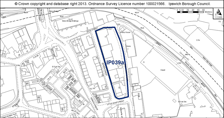
Proposed Allocation Policy DM39
|
Use(s) |
% of site |
Density of housing (H, M, L)* |
Indicative capacity |
|
Housing |
100% |
M-H |
43 |
* see Core Strategy policy DM30 for average densities.
Preferred Option 2007 For whole of IP040
80% housing at high density – 144 dwellings
20% community use, workshops
Current use
Part vacant industrial buildings.
Development constraints / issues
In a flood zone, close to an Air Quality Management Area, adjacent to a listed building and conservation area, within area of archaeological importance, and possible contamination. Development principles for the Island Site Opportunity Area, within which the site is located, are set out in Chapter 7 of the Site Allocations and Policies plan (see ‘Opportunity Area A’).
Site ref: IP040 & 041 (UC041 & 42) Civic Centre Area / Civic Drive
Site area: 1.31ha
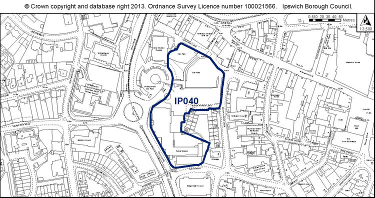
Proposed Allocation Policy DM39 & Policy DM49
|
Use(s) |
% of site |
Density of housing (H, M, L)* |
Indicative capacity |
|
Housing Primarily retail |
20% 80% |
H |
28 |
* see Core Strategy policy DM30 for average densities.
Preferred Option 2007 Included as two separate sites previously.
IP041 20% housing at high density – 24 dwellings, 60% retail, 20% B1 employment
IP042 50% housing at high density – 43 dwellings, 50% B1 employment
Current use
Vacant development site, former county court, police station.
Development constraints / issues
Awaiting completion of the Police Station relocation. Residential use could be located above retail uses. In an area of archaeological importance, adjacent to a conservation area, possible contamination. Development principles for Westgate Opportunity Area, within which the site is located, are set out in Chapter 7 of the Site Allocations and Policies plan (see ‘Opportunity Area E’).
Site ref: IP043 (UC044) Commercial Buildings and Jewish Burial Ground, Star Lane
Site area: 0.70ha
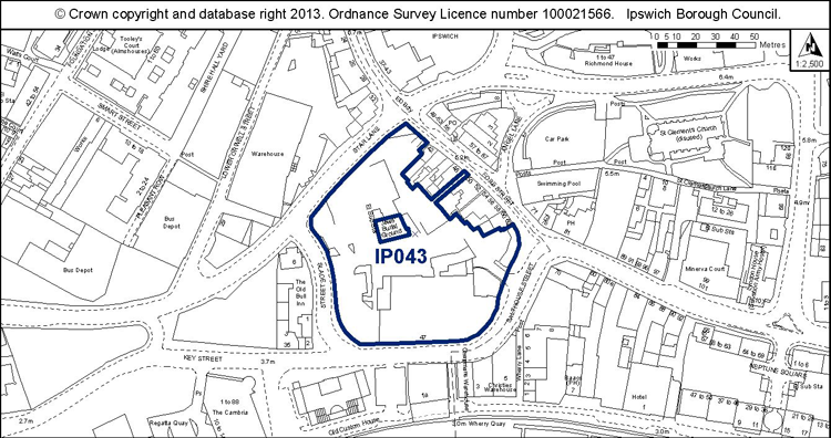
Proposed Allocation Policy DM39
|
Use(s) |
% of site |
Density of housing (H, M, L)* |
Indicative capacity |
|
Housing Employment B1 / Leisure |
80% 20% |
H (at lower end of range) |
61 |
* see Core Strategy policy DM30 for average densities.
Preferred Option 2007
No allocation in 2007, as the site had planning permission for commercial and residential mixed use.
Current use
Vacant site, Jewish burial ground
Development constraints / issues
Access, Air Quality Management Area, area of archaeological importance, within a conservation area, flood risk, listed buildings on site or nearby. Considered unlikely to come forward for student accommodation (11/00267/FUL), hence inclusion in policy. Development principles for the Merchant Quarter, within which the site is located, are set out in Chapter 7 of the Site Allocations and Policies plan (see ‘Opportunity Area B’).
Site ref: IP048 (UC051) Mint Quarter east of Cox Lane
Site area: 1.35ha
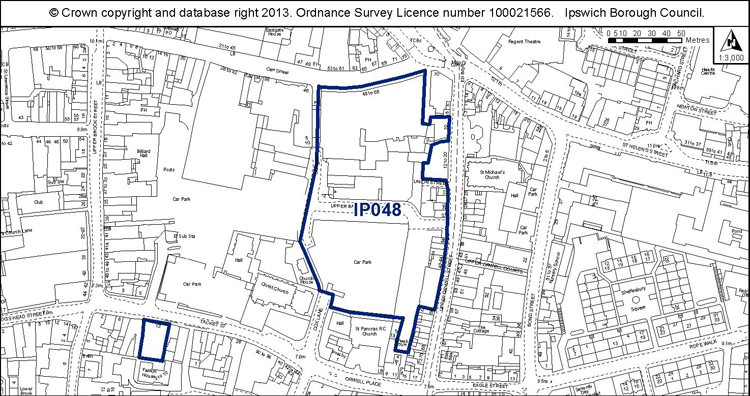
Proposed Allocation Policies DM39 & DM43
|
Use(s) |
% of site |
Density of housing (H, M, L)* |
Indicative capacity |
|
Housing Open space and short stay multi-storey car parking |
60% 40% |
H (lower end of range) |
73 |
* see Core Strategy policy DM30 for average densities.
Preferred Option 2007 (For whole site, east and west of Cox Lane)
20% housing at high density – 89 dwellings
80% retail, car park and food & drink
Current use
Surface level short stay car parking, vacant shops
Development constraints / issues
Short stay parking for shoppers needed and the provision of public open space within the site, however part of these could span Cox Lane into the west part of the site also. A development brief for the whole site (east and west of Cox Lane) will be prepared but development may come forward incrementally.
Close to an Air Quality Management Area, in an area of archaeological importance, adjacent to a conservation area and listed buildings, possible contamination and TPOs on site or nearby. The locally listed façade to Carr Street is to be retained.
Development principles for the Mint Quarter / Cox Lane regeneration area, within which the site is located, are set out in Chapter 7 of the Site Allocations and Policies development plan document (see ‘Opportunity Area C’).
Site ref: IP049 (UC052) No. 8 Shed, Orwell Quay
Site area: 0.76ha
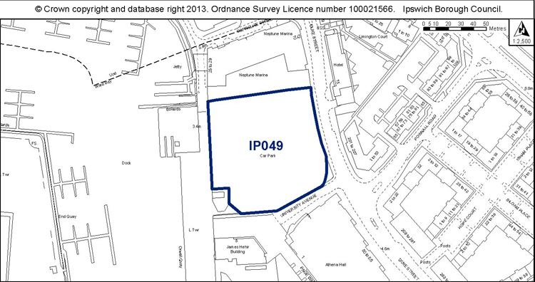
Proposed Allocation Policy DM53
|
Use(s) |
% of site |
Density of housing (H, M, L)* |
Indicative capacity |
|
Education and ancillary uses / Waterfront uses Public car parking |
N/A |
N/A |
N/A |
* see Core Strategy policy DM30 for average densities.
Preferred Option 2007
50% housing at high density – 62 dwellings; 20% hotel; 20% public car parking and 10% small scale leisure / retail.
Current use
Temporary surface level long stay car parking.
Development constraints / issues
Within a flood zone and an area of archaeological importance and close to an Air Quality Management Area. It is adjacent to a conservation area and there may be contamination.
Site ref: IP051 (UC054) Old Cattle Market, Portman Road - South
Site area: 2.21ha
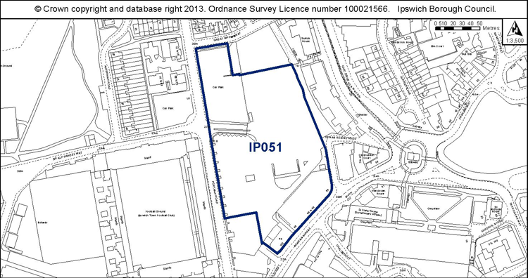
Proposed Allocation Policy DM42
|
Use(s) |
% of site |
Density of housing (H, M, L)* |
Indicative capacity |
|
Employment B1 office Hotel/leisure |
80% 20% |
N/A |
N/A |
* see Core Strategy policy DM30 for average densities.
Preferred Option 2007
40% large scale leisure; 20% employment; 10% hotel; 20% housing at high density – 83 dwellings; 10% small scale retail / food and drink
Current use
Surface level long stay car parking, public house, vacant former car showroom.
Development constraints / issues
Need to replace the existing car parking before the site can be redeveloped. Possible contamination and in a flood zone. Development principles for River Corridor and Princes Street Corridor Opportunity Area, within which the site is located, are set out in Chapter 7 of the Site Allocations and Policies plan (see ‘Opportunity Area F’). They include creating a new townscape of well defined blocks east of Portman Road.
Site ref: IP052 (UC055) Land between Lower Orwell Street & Star Lane
Site area: 0.40ha
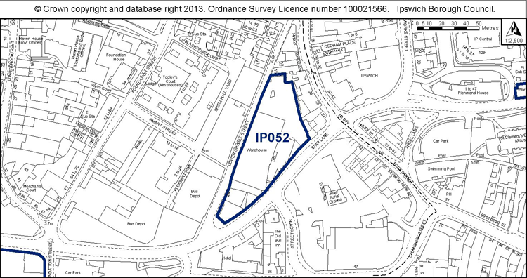
Proposed Allocation Policy DM42
|
Use(s) |
% of site |
Density of housing (H, M, L)* |
Indicative capacity |
|
Housing Employment B1 office |
80% 20% |
N/A |
N/A |
* see Core Strategy policy DM30 for average densities.
Preferred Option 2007
80% housing at high density – 53 dwellings
20% employment B1 office
Current use
Vacant warehouse, gym, hand car wash, temporary car parking.
Development constraints / issues
Within an Air Quality Management Area and area of archaeological importance and adjacent to a conservation area and a listed building. Possible contamination and part within a flood zone. Development principles for the Merchant Quarter, within which the site is located, are set out in Chapter 7 of the Site Allocations and Policies plan (see ‘Opportunity Area B’).
Site ref: IP054 (UC057) Land between Old Cattle Market & Star Lane
Site area: 1.72ha
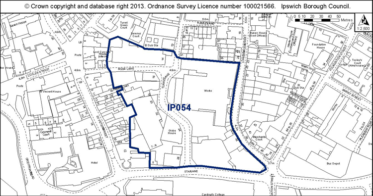
Proposed Allocation Policies DM39 & DM42
|
Use(s) |
% of site |
Density of housing (H, M, L)* |
Indicative capacity |
|
Housing B1 office, leisure - electricity sub station, possible car parking, some small scale retail |
30% 70% |
M (@55 dwellings per ha) |
28 |
* see Core Strategy policy DM30 for average densities.
Preferred Option 2007
50% housing at high density – 141 dwellings
30% B1 employment and electricity sub station
20% small scale retail, leisure, food and drink
Current use
West side various employment uses, car parking. East side vacant Archant works and car parking.
Development constraints / issues
Redevelopment will be dependent on the intentions of existing businesses.
Development principles for the Merchant Quarter, within which the site is located, are set out in Chapter 7 of the Site Allocations and Policies development plan document (see ‘Opportunity Area B’). They include, for example, a layout to relate to the historic street pattern and enhanced pedestrian linkage between the town centre and the Waterfront.
There is a need to protect land for an extension to the electricity sub station or new provision within the site. Part of the Lower Brook Street frontage is within a conservation area and should be retained.
It is within or close to an Air Quality Management Area, in an area of archaeological importance, and part within a flood zone at the southern end of the site. There are TPOs on site or nearby.
(1) Site ref: IP055 (UC058) Crown Car Park, Charles Street
Site area: 0.70ha
Proposed Allocation Policy DM57
|
Use(s) |
% of site |
Density of housing (H, M, L)* |
Indicative capacity |
|
Public car park |
100% |
N/A |
N/A |
* see Core Strategy policy DM30 for average densities.
Preferred Option 2007 As part of a larger site for comprehensive redevelopment:
30% retail
20% housing at high density – 64 dwellings
25% employment
25% multi storey car park
Current use
Public car parking.
Development constraints / issues
Close to an Air Quality Management Area, and adjacent to a conservation area and TPO protected trees.
Site ref: IP058 (UC061) Former Volvo Site, Raeburn Road South
Site area: 5.85ha
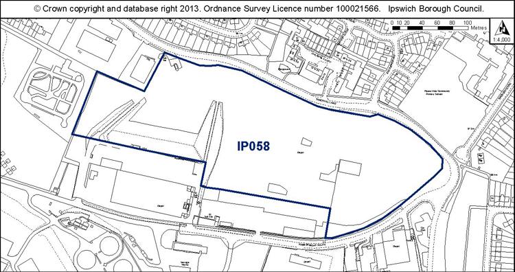
Proposed Allocation Policy DM42
|
Use(s) |
% of site |
Density of housing (H, M, L)* |
Indicative capacity |
|
Employment (B1, B2, B8) |
100% |
N/A |
N/A |
* see Core Strategy policy DM30 for average densities.
Preferred Option 2007
50% housing at low density – 102 dwellings
50% employment
Current use
Part used as external storage space.
Development constraints / issues
Access constraints, possible contamination, odour from the sewage works and the site is within a Landfill consultation zone. It is a designated County Wildlife Site although this may need to be reviewed because the quality of its flora has changed since designation. It has wildlife value, however, and forms part of the ecological network. A reptile survey will be needed prior to any vegetation clearance, and mitigation where appropriate. New development will need to incorporate wildlife corridors. Please refer to the Ipswich Wildlife Audit 2012.
Site ref: IP059a (UC062 part) Elton Park Industrial Estate
Site area: 2.63ha
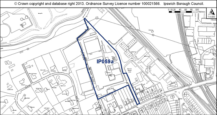
Proposed Allocation Policy DM39
|
Use(s) |
% of site |
Density of housing (H, M, L)* |
Indicative capacity |
|
Housing |
100% |
L-M |
105 |
* see Core Strategy policy DM30 for average densities.
Preferred Option 2007 On a larger site of 6.61ha including the employment uses to the east
50% housing at medium density – 165 dwellings
50% employment
Current use
Vacant employment site with redundant buildings.
Development constraints / issues
Need to ensure land is safeguarded to land a pedestrian and cycle bridge to the river path (see Policy DM45). East side of site to remain in employment uses.
Possible contamination, TPO on site or nearby and adjacent to a flood zone.
(4) Site ref: IP061 (UC064) School Site, Lavenham Road
Site area: 1.08ha
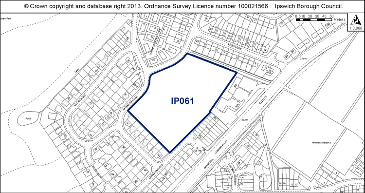
Proposed Allocation Policies DM39 & DM43
|
Use(s) |
% of site |
Density of housing (H, M, L)* |
Indicative capacity |
|
Housing Open space |
70% 30% |
L-M |
30 |
* see Core Strategy policy DM30 for average densities.
Preferred Option 2007
Proposed new primary school.
Current use
Open space.
Development constraints / issues
The site is no longer required for a new school. The site was identified through the Open Space Sport and Recreation Study as park and garden and is used for informal recreation. It was identified as a school site through the 1997 Local Plan. The proposal is that 70% of the site is used for housing to improve the remaining open space. The type of open space provision would need to be agreed with the Council’s Parks and Open Spaces Service.
Site ref: IP065 (UC068) Former 405 Club, Bader Close
Site area: 3.22ha
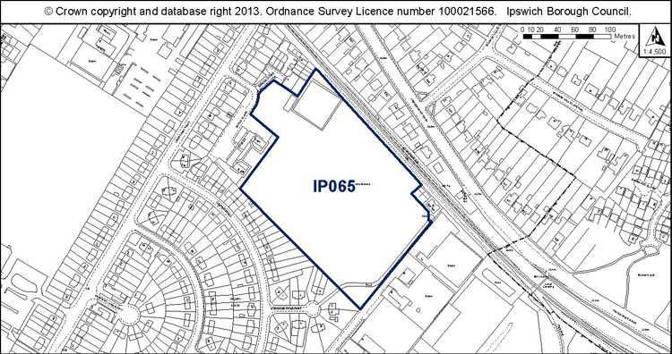
Proposed Allocation Policy DM39
|
Use(s) |
% of site |
Density of housing (H, M, L)* |
Indicative capacity |
|
Housing as per planning application |
100% |
L |
108 |
* see Core Strategy policy DM30 for average densities.
Preferred Option
50% housing at medium density – 89 dwellings
50% Open space
Current use
Informal unmanaged open space, good quality wildlife habitat.
Development constraints / issues
The design and layout should support the wildlife corridor function of the railway and have regard to the recorded presence of protected species.
The loss of a former playing field needs to be addressed.
Possible contamination.
Site ref: IP066 (UC069) JJ Wilson, White Elm Street
Site area: 0.32ha (includes land adjacent to the west not previously included)
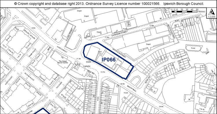
Proposed Allocation Policy DM39
|
Use(s) |
% of site |
Density of housing (H, M, L)* |
Indicative capacity |
|
Housing |
100% |
M |
14 |
* see Core Strategy policy DM30 for average densities.
Preferred Option
100% housing at medium density – 12 dwellings
Current use
Warehousing.
Development constraints / issues
Need to relocate the existing businesses first.
Possible contamination and close to an AQMA.
Site ref: IP067 (UC070) Former British Energy Site
Site area: 5.25ha
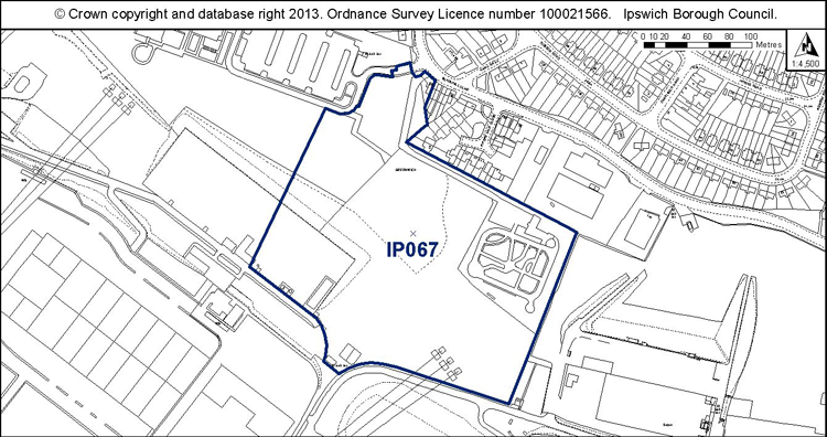
Proposed Allocation Policy DM42
|
Use(s) |
% of site |
Density of housing (H, M, L)* |
Indicative capacity |
|
Employment (B1 office) |
100% |
N/A |
N/A |
* see Core Strategy policy DM30 for average densities.
Preferred Option
50% housing at low density – 50 dwellings
50% employment
Current use
Vacant former British Energy Site
Development constraints / issues
Access constraints, odour from the sewage works, possible contamination and the site is within a Landfill consultation zone. It is adjacent to a County Wildlife Site and forms part of the ecological network.
(1) Site ref: IP080 (UC085) 240 Wherstead Road
Site area: 0.49ha
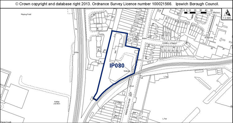
Proposed Allocation Policy DM39
|
Use(s) |
% of site |
Density of housing (H, M, L)* |
Indicative capacity |
|
Housing |
100% |
M (@55 dwellings per ha) |
27 |
* see Core Strategy policy DM30 for average densities.
Preferred Option
100% housing at low density – 20 dwellings
Current use
Vacant land and buildings.
Development constraints / issues
The layout should support the wildlife corridor function of the railway line.
Possible contamination and adjacent to a flood zone. Also noise from the adjacent railway line.
Site ref: IP083 (UC089) Banks of river upriver from Princes Street
Site area: 0.76ha
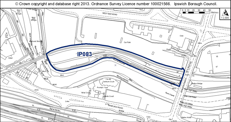
Proposed Allocation Policy DM43
|
Use(s) |
% of site |
Density of housing (H, M, L)* |
Indicative capacity |
|
Public open space Housing, if planned with IP015 to the north |
80% Up to 20% |
(IP015 H) |
N/A |
* see Core Strategy policy DM30 for average densities.
Preferred Option
Open space, riverside path, public transport route, possible small scale retail / leisure / food & drink.
Current use
River path, overgrown areas, disused railway tracks.
Development constraints / issues
The site needs to be planned comprehensively with site IP015 adjacent to the north. Any redevelopment would need to retain the river path and its setting. Possible contamination, flood risk and it is adjacent to a listed building. The site has potential wildlife interest – reptile and otter surveys will be needed prior to any vegetation clearance, and mitigation where appropriate. Please refer to the Ipswich Wildlife Audit 2012.
Site ref: IP089 (UC096) Waterworks Street
Site area: 0.31ha
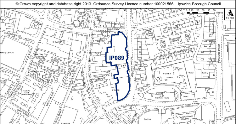
Proposed Allocation Policy DM39
|
Use(s) |
% of site |
Density of housing (H, M, L)* |
Indicative capacity |
|
Housing |
100% |
H |
29 |
* see Core Strategy policy DM30 for average densities.
Preferred Option
100% housing at medium density – 17 dwellings
Current use
Car park
Development constraints / issues
It is part within a conservation area and adjacent to a listed building. TPO on site or nearby, within an area of archaeological importance, possible contamination and close to an Air Quality Management Area.
Site ref: IP094 (UC104) Land to rear of Grafton house
Site area: 0.31ha
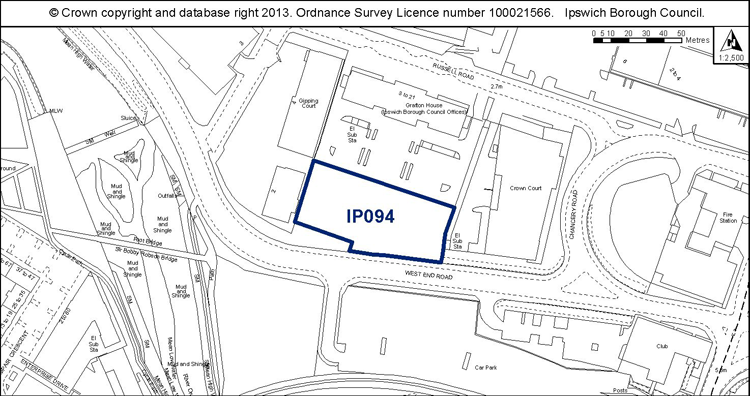
Proposed Allocation Policy DM42
|
Use(s) |
% of site |
Density of housing (H, M, L)* |
Indicative capacity |
|
Employment (B1 office) |
100% |
N/A |
N/A |
* see Core Strategy policy DM30 for average densities.
Preferred Option
100% B1 employment
Current use
Vacant site
Development constraints / issues
Access constraints, possible contamination, and there is a TPO adjacent to the site.
Site ref: IP096 (UC109) Car Park, Handford Road East
Site area: 0.22ha
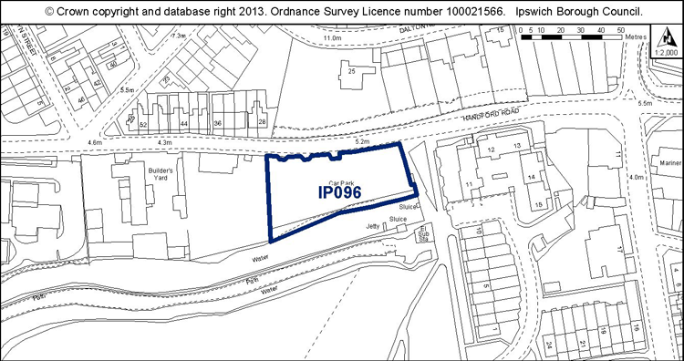
Proposed Allocation Policy DM39
|
Use(s) |
% of site |
Density of housing (H, M, L)* |
Indicative capacity |
|
Housing |
100% |
H |
24 |
* see Core Strategy policy DM30 for average densities.
Preferred Option
100% housing at medium density – 12 dwellings
Current use
Car park (temporary permission).
Development constraints / issues
Within Ipswich Village, housing densities should be high (Policy DM30) therefore the capacity has been increased. The development by McCarthy and Stone on the site to the west also suggests that high density may be appropriate here. Design and layout would need to support the wildlife corridor function of the canal which is also a County Wildlife Site and Local Nature Reserve. The site is part within the flood plain and opposite a conservation area. Possible contamination.
Site ref: IP098 (UC111) Transco south of Patteson Road
Site area: 0.57ha
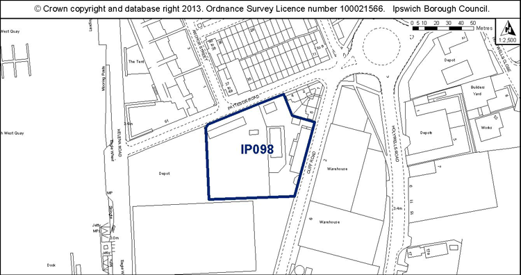
Proposed Allocation Policy DM39
|
Use(s) |
% of site |
Density of housing (H, M, L)* |
Indicative capacity |
|
Housing |
100% |
H |
63 |
* see Core Strategy policy DM30 for average densities.
Preferred Option
100% housing at high density – 94 dwellings
Current use
Gas governor.
Development constraints / issues
Need to relocate the existing gas governor first.
Flood risk, contamination and close to an Air Quality Management Area.
Site ref: IP099 (UC133) Part former Volvo Site, Raeburn Road South
Site area: 2.29ha
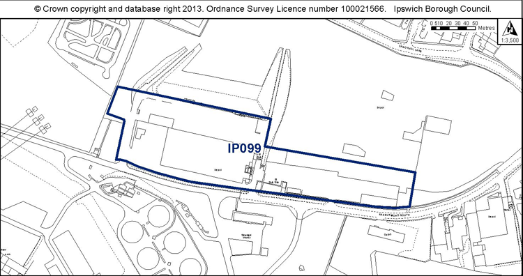
Proposed Allocation Policy DM42
|
Use(s) |
% of site |
Density of housing (H, M, L)* |
Indicative capacity |
|
Employment |
100% |
N/A |
N/A |
* see Core Strategy policy DM30 for average densities.
Preferred Option
100% employment
Current use
Vacant employment site
Development constraints / issues
Possible contamination, odour from the sewage works.
Site ref: IP105 (UC129) Depot, Beaconsfield Road
Site area: 0.33ha
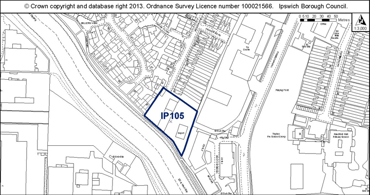
Proposed Allocation Policy DM39
|
Use(s) |
% of site |
Density of housing (H, M, L)* |
Indicative capacity |
|
Housing |
100% |
M |
15 |
* see Core Strategy policy DM30 for average densities.
Preferred Option
100% housing at medium density – 19 dwellings
Current use
Depot.
Development constraints / issues
Need to relocate the existing business first.
The site lies within a flood zone and a landfill consultation zone. Possible contamination. The design and layout would need to address the river frontage and support its wildlife corridor function.
(2) Site ref: IP116 (UC185) St Clement’s Hospital Grounds
Site area: 12.51ha
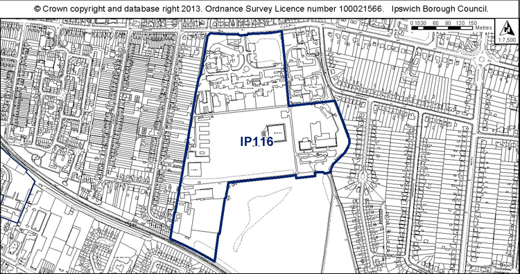
Proposed Allocation Policies DM39 & DM43
|
Use(s) |
% of site |
Density of housing (H, M, L)* |
Indicative capacity |
|
Housing Open space & sports facilities |
c. 60% c. 40% |
L |
227 |
* see Core Strategy policy DM30 for average densities.
Preferred Option
80% housing at medium density – 512 dwellings
20% open space
Current use
Hospital and grounds including sports facilities.
Development constraints / issues
Need to relocate the remaining health service uses first. Sports facilities should be retained or replaced.
TPOs on site or nearby, adjacent to a local wildlife site (the golf course). Design and layout should support wildlife corridor functions. Bat and reptile surveys will be required prior to any vegetation clearance, and mitigation where appropriate. Please refer to the Ipswich Wildlife Audit 2012.
Site ref: IP121 (UC209) Front of Pumping Station, Belstead Road
Site area: 0.60ha
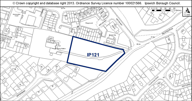
Proposed Allocation Policy DM39
|
Use(s) |
% of site |
Density of housing (H, M, L)* |
Indicative capacity |
|
Housing |
100% |
M |
27 |
* see Core Strategy policy DM30 for average densities.
Preferred Option
100% housing at medium density – 33 dwellings
Current use
Landscaped grounds to pumping station.
Development constraints / issues
Need to retain access to the pumping station.
Possible access constraints and contamination. The woodland is of ecological value and should be retained if possible. If mature trees are to be lost, a bat survey will be needed prior to any vegetation clearance, and mitigation where appropriate. Consideration should be given to the likely presence of stag beetle. Please refer to the Ipswich Wildlife Audit 2012.
Site ref: IP131 (N/A) 488-496 Woodbridge Road
Site area: 0.37ha
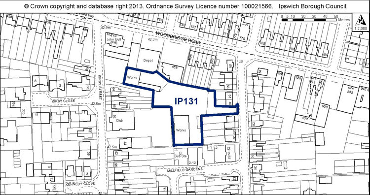
Proposed Allocation Policy DM39
|
Use(s) |
% of site |
Density of housing (H, M, L)* |
Indicative capacity |
|
Housing |
100% |
M |
13 |
* see Core Strategy policy DM30 for average densities.
Preferred Option
N/A
Current use
Vehicle repair workshops
Development constraints / issues
Need to relocate the existing uses first. The site previously had planning permission for 34 dwellings (now lapsed) but it is considered unlikely that such a dense development would be delivered, hence the reduction in the capacity.
Possible contamination.
Site ref: IP136 (UC251) Silo, College Street
Site area: 0.16ha
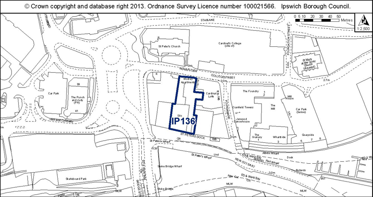
Proposed Allocation Policy DM39
|
Use(s) |
% of site |
Density of housing (H, M, L)* |
Indicative capacity |
|
Housing Employment (B1 office) / small scale retail or leisure |
80% 20% |
H |
21 |
* see Core Strategy policy DM30 for average densities.
Preferred Option
80% housing at high density – 21 dwellings
20% Small scale retail or employment
Current use
Vacant building, temporary car park.
Development constraints / issues
Access constraints, Air Quality Management Area, Area of Archaeological Importance, conservation area, possible contamination, flood risk, adjacent to a listed building.
(2) Site ref: IP140a (UC257) Land North of Whitton Lane
Site area: 1.01ha
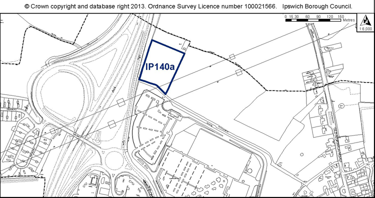
Proposed Allocation Policy DM45
|
Use(s) |
% of site |
Density of housing (H, M, L)* |
Indicative capacity |
|
Park and ride extension |
100% |
N/A |
N/A |
* see Core Strategy policy DM30 for average densities.
Preferred Option 2007
No allocation.
Current use
Grassland.
Development constraints / issues
Access constraints, noise from the A14 and the need to support wildlife and recreational green corridor functions associated with the ‘green rim’ (see e.g. Core Strategy Policy CS16, Site Allocations and Policies DPD draft policies DM33 and DM34). The hedgerows and mature trees have the greatest wildlife value, but further surveys will be needed prior to any vegetation clearance to establish the full wildlife interest, including for birds and reptiles, and mitigation where appropriate. Please refer to the Ipswich Wildlife Audit 2012.
(2) Site ref: IP140b (UC257) Land North of Whitton Lane
Site area: 5.92ha
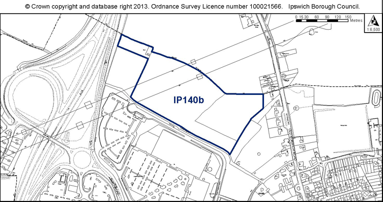
Proposed Allocation Policy DM42
|
Use(s) |
% of site |
Density of housing (H, M, L)* |
Indicative capacity |
|
Employment park primarily B1 with some B2 and B8 |
100% |
N/A |
N/A |
* see Core Strategy policy DM30 for average densities.
Preferred Option 2007
No allocation.
Current use
Grassland.
Development constraints / issues
Access constraints, noise from the A14 and the need to support wildlife and recreational green corridor functions associated with the ‘green rim’ (see e.g. Core Strategy Policy CS16, Site Allocations and Policies DPD draft policies DM33 and DM34). The hedgerows and mature trees have the greatest wildlife value, but further surveys will be needed prior to any vegetation clearance to establish the full wildlife interest, including for birds and reptiles, and mitigation where appropriate. Please refer to the Ipswich Wildlife Audit 2012.
Site ref: IP142 (UC259) Land at Duke Street
Site area: 0.39ha
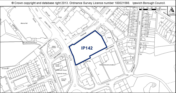
Proposed Allocation Policies DM39 & DM43
|
Use(s) |
% of site |
Density of housing (H, M, L)* |
Indicative capacity |
|
Housing Public open space |
75% 25% |
H |
32 |
* see Core Strategy policy DM30 for average densities.
Preferred Option 2007
Education use
Current use
Vacant land.
Development constraints / issues
Close to an Air Quality Management Area, possible contamination, and TPOs on site or nearby.
(1) Site ref: IP146 (UC263) Ransomes Europark East
Site area: 5.29ha
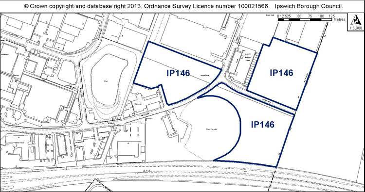
Proposed Allocation Policy DM42
|
Use(s) |
% of site |
Density of housing (H, M, L)* |
Indicative capacity |
|
Employment |
100% |
N/A |
N/A |
* see Core Strategy policy DM30 for average densities.
Preferred Option 2007
100% employment
Current use
Vacant land within defined Employment Area
Development constraints / issues
Adjacent to wildlife sites forming part of the ecological network. The site has potential wildlife interest – heathland and acid grassland habitat should be retained and managed appropriately. A reptile survey will be needed prior to any vegetation clearance, and mitigation where appropriate. Please refer to the Ipswich Wildlife Audit 2012.
(1) Site ref: IP147 (UC264) Land between railway junction and Hadleigh Road
Site area: 4.7ha
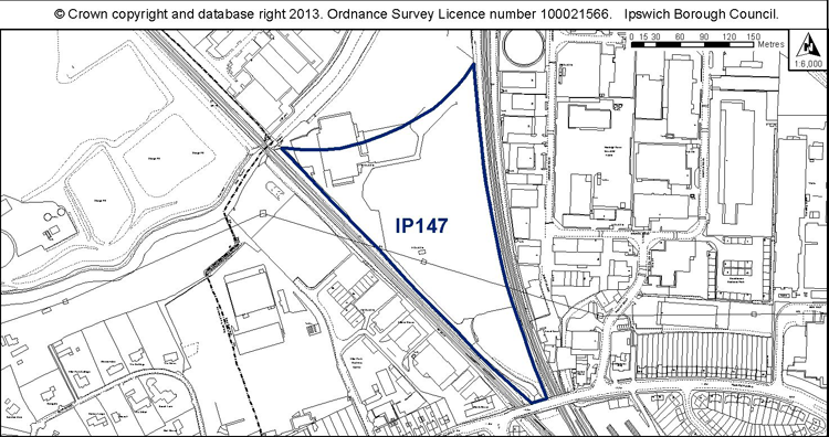
Proposed Allocation Policy DM42
|
Use(s) |
% of site |
Density of housing (H, M, L)* |
Indicative capacity |
|
Employment (B1 office) |
100% |
N/A |
N/A |
* see Core Strategy policy DM30 for average densities.
Preferred Option 2007
100% employment and land for the rail chord
Current use
Vacant employment land
Development constraints / issues
Access constraints, possible contamination, within a flood zone, and adjacent to a County Wildlife Site (the river). Development would need to also support the wildlife corridor function of the railways.
Site ref: IP149 (UC266) Pond Hall Farm
Site area: 24.7ha
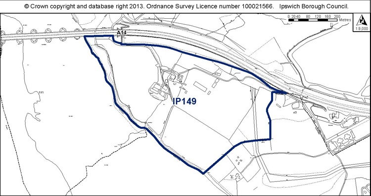
Proposed Allocation Policy DM44
|
Use(s) |
% of site |
Density of housing (H, M, L)* |
Indicative capacity |
|
Country Park extension and visitors’ centre |
100% |
N/A |
N/A |
* see Core Strategy policy DM30 for average densities.
Preferred Option 2007
No allocation
Current use
Farm land
Development constraints / issues
Access constraints, possible contamination, adjacent to a Ramsar Site and Special Protection Area for Birds.
(2) Site ref: IP150b (UC267 part) Land south of Ravenswood
Site area: 9.60ha
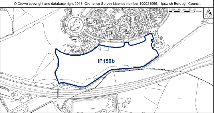
Proposed Allocation Policy DM44
|
Use(s) |
% of site |
Density of housing (H, M, L)* |
Indicative capacity |
|
Sports Park comprising cycle track and playing pitches |
100% |
N/A |
N/A |
* see Core Strategy policy DM30 for average densities.
Preferred Option 2007
No allocation, as the site had outline planning permission for a mix of uses including employment and a local plan allocation for employment and a sports park.
Current use
Vacant land, informal open space.
Development constraints / issues
Access constraints – should be master planned comprehensively with the Airport Farm Kennels site to the south and improvements to this part of the Nacton Road corridor between junction 57 and the Ransomes Way/Nacton Road junction to create an attractive gateway to Ipswich. Possible drainage constraints. The site has potential wildlife interest – reptile and invertebrate surveys will be needed prior to any vegetation clearance, and mitigation where appropriate. Please refer to the Ipswich Wildlife Audit 2012.
(3) Site ref: IP150c (UC267) Land south of Ravenswood
Site area: 4.62ha
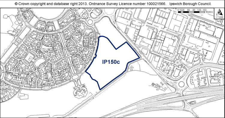
Proposed Allocation Policy DM39
|
Use(s) |
% of site |
Density of housing (H, M, L)* |
Indicative capacity |
|
Housing |
100% |
L |
162 |
* see Core Strategy policy DM30 for average densities.
Preferred Option 2007
No allocation, as the site had outline planning permission for a mix of uses including employment and a local plan allocation for employment and a sports park.
Current use
Vacant land, informal open space.
Development constraints / issues
Access constraints – should be master planned comprehensively with the Airport Farm Kennels site to the south and improvements to this part of the Nacton Road corridor between junction 57 and the Ransomes Way/Nacton Road junction to create an attractive gateway to Ipswich. Drainage constraints.
The site has potential wildlife interest – reptile and invertebrate surveys will be prior to any vegetation clearance, and mitigation where appropriate.. Please refer to the Ipswich Wildlife Audit 2012.
(4) Site ref: IP152 (UC269) Airport Farm Kennels, north of the A14
Site area: 7.37ha
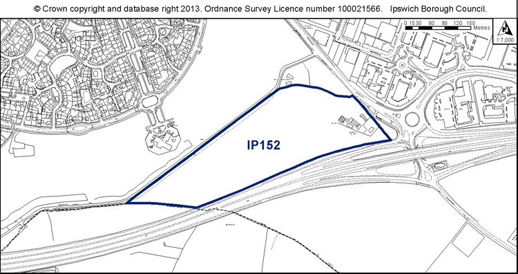
Proposed Allocation Policy DM42
|
Use(s) |
% of site |
Density of housing (H, M, L)* |
Indicative capacity |
|
Employment (B1, B2, B8) |
100% |
N/A |
N/A |
* see Core Strategy policy DM30 for average densities.
Preferred Option 2007
50% park and ride
50% retain existing use
Current use
Farm land.
Development constraints / issues
Access constraints – should be master planned comprehensively with the Ravenswood site to the north (IP150c) and improvements to this part of the Nacton Road corridor between junction 57 and the Ransomes Way/Nacton Road junction to create an attractive gateway to Ipswich. Possible area of archaeological importance, possible contamination, TPO on site or nearby, Area of Outstanding Natural Beauty on part and noise from the A14. The site has potential wildlife interest – a reptile survey will be needed prior to any vegetation clearance, and mitigation where appropriate. Mature oaks and hedges should be retained. Please refer to the Ipswich Wildlife Audit 2012.
Site ref: IP165 (N/A) Eastway Business Park, Europa Way
Site area: 2.08ha
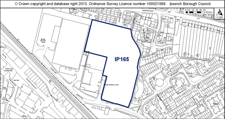
Proposed Allocation Policy DM39
|
Use(s) |
% of site |
Density of housing (H, M, L)* |
Indicative capacity |
|
Housing |
100% |
M |
100 |
* see Core Strategy policy DM30 for average densities.
Preferred Option 2007
N/A
Current use
Vacant land.
Development constraints / issues
Possible access constraints, possible contamination.
Previously had planning permission for 218 dwellings but this is considered undeliverable and discussions with the landowner indicate that 100 dwellings is a more realistic capacity.
Site ref: IP172 (UC088) 15-19 St Margaret’s Green
Site area: 0.08ha
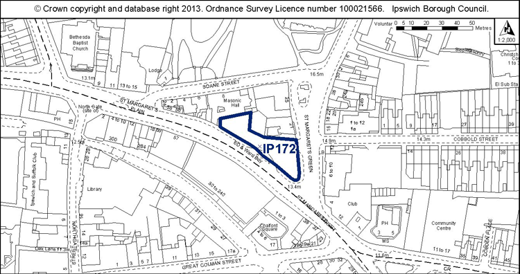
Proposed Allocation Policy DM39
|
Use(s) |
% of site |
Density of housing (H, M, L)* |
Indicative capacity |
|
Housing |
100% |
H |
9 |
* see Core Strategy policy DM30 for average densities.
Preferred Option 2007
No allocation because it is too small and already had planning permission for flats.
Current use
Vacant land.
Development constraints / issues
Previous permissions have not been implemented (for flats and student accommodation). The site is below the threshold for allocation but because of its prominent location, it is considered appropriate to plan positively for the site.
Within an Air Quality Management Area, an area of archaeological importance and a conservation area, adjacent to listed buildings and possible contamination.
Site ref: IP175 (N/A) 47-51 Waveney Road
Site area: 0.15ha
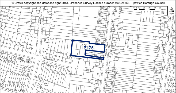
Proposed Allocation Policy DM39
|
Use(s) |
% of site |
Density of housing (H, M, L)* |
Indicative capacity |
|
Housing |
100% |
M-H (reflects planning permission now lapsed) |
12 |
* see Core Strategy policy DM30 for average densities.
Preferred Option 2007
N/A
Current use
Vehicle repair workshops.
Development constraints / issues
Need to relocate the existing business first. Previously had outline planning permission for 12 dwellings.
Possible contamination.
Site ref: IP188 (N/A) Webster’s Saleyard Site, Dock Street
Site area: 0.11ha
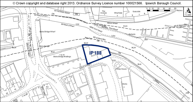
Proposed Allocation Policy DM39
|
Use(s) |
% of site |
Density of housing (H, M, L)* |
Indicative capacity |
|
Housing |
100% |
H |
9 |
* see Core Strategy policy DM30 for average densities.
Preferred Option 2007
100% housing at high density – 9 dwellings
Current use
Vacant site. Planning permission for 3 flats on part of the site.
Development constraints / issues
Area of archaeological importance, conservation area, contamination, flood risk, adjacent to a listed building.
There is an aspiration for a cycle and pedestrian crossing to St Peter’s Quay/ the Island Site immediately to the east of this site.
Development would need to address the river frontage and support the wildlife corridor function of the river. Development principles for the Island Site Opportunity Area, within which the site is located, are set out in Chapter 7 of the Site Allocations and Policies plan (see ‘Opportunity Area A’).
Site ref: IP221 (N/A) The Flying Horse PH, 4 Waterford Road
Site area: 0.35ha
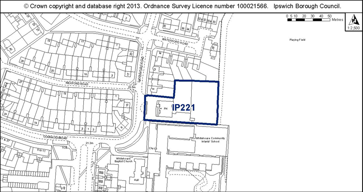
Proposed Allocation Policy DM39
|
Use(s) |
% of site |
Density of housing (H, M, L)* |
Indicative capacity |
|
Housing Retain existing public house |
50% 50% |
L |
6 |
* see Core Strategy policy DM30 for average densities.
Preferred Option 2007
N/A
Current use
Pub and vacant land.
Development constraints / issues
Planning permission for 12 dwellings has recently lapsed.
Possible access constraints, TPO on site or nearby.
(1) Site ref: IP256 (N/A) Artificial Hockey Pitch, Ipswich Sports Club, Henley Rd
Site area: 0.87ha
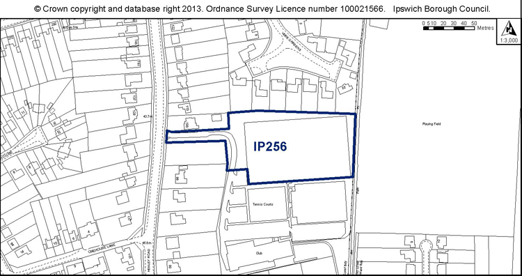
Proposed Allocation Policy DM39
|
Use(s) |
% of site |
Density of housing (H, M, L)* |
Indicative capacity |
|
Housing |
100% |
L |
30 |
* see Core Strategy policy DM30 for average densities.
Preferred Option 2007
N/A new site
Current use
Sports facility – all weather pitch.
Development constraints / issues
Need to satisfactorily relocate the pitch in accordance with policy DM28 first.
TPO along the eastern boundary. Possible drainage constraint.
(2) Site ref: IP257 (N/A) Land at Felixstowe Road east of Malvern Close
Site area: 0.78ha
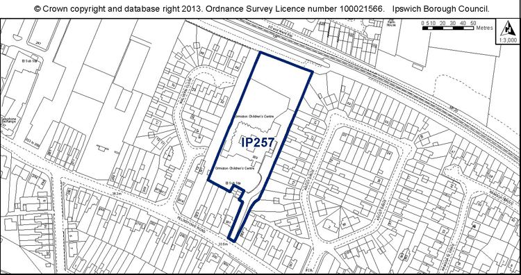
Proposed Allocation Policy DM39
|
Use(s) |
% of site |
Density of housing (H, M, L)* |
Indicative capacity |
|
Housing |
100% |
L |
27 |
* see Core Strategy policy DM30 for average densities.
Preferred Option 2007
N/A – new site
Current use
Ormiston Children’s Centre and offices.
Development constraints / issues
Need to relocate the existing children’s centre and offices first.
Possible contamination.
(1) Site ref: IP258 (N/A) Land at University Campus Suffolk
Site area: 1.89ha
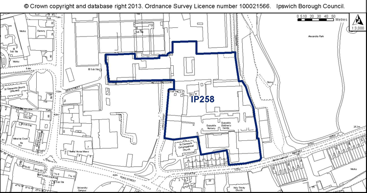
Proposed Allocation Policy DM44
|
Use(s) |
% of site |
Density of housing (H, M, L)* |
Indicative capacity |
|
New Primary School |
100% |
N/A |
* see Core Strategy policy DM30 for average densities.
Preferred Option 2007
N/A – new site
Current use
Educational buildings and car parking within the University Campus Suffolk campus.
Development constraints / issues
Adjacent to an Air Quality Management Area and the Central Conservation Area. There are TPO protected trees on and adjacent to the site, and footpaths. Possible contamination.
Site ref: IP259 (N/A) Former Holywells High School (buildings)
Site area: 1.82ha
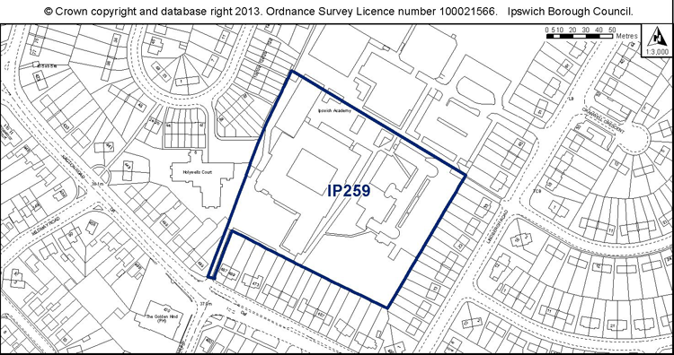
Proposed Allocation Policy DM39
|
Use(s) |
% of site |
Density of housing (H, M, L)* |
Indicative capacity |
|
Housing |
100% |
M |
82 |
* see Core Strategy policy DM30 for average densities.
Preferred Option 2007
N/A – new site
Current use
Former Holywells High School / Ipswich Academy
Development constraints / issues
Access constraints. The Ipswich Academy has now relocated to its new site on Braziers Wood Road but there is a prescribed period which needs to expire to ensure there is no further interest in operating a school at the old site (December 2013). Also need to satisfy Policy DM32 that the facility is no longer needed.
Development is required to retain the playing fields and built sports facilities which have been excluded from the allocation.
TPO on site or nearby.
Site ref: IP260 (UC N/A) Former Odeon Cinema, St Margaret’s Street
Site area: 0.20ha
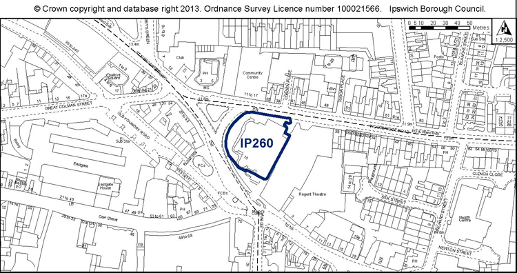
Proposed Allocation Policy DM44
|
Use(s) |
% of site |
Density of housing (H, M, L)* |
Indicative capacity |
|
Leisure uses to complement the Regent Theatre |
100% |
N/A |
N/A |
* see Core Strategy policy DM30 for average densities.
Preferred Option 2007
N/A – new site
Current use
Vacant cinema.
Development constraints / issues
Close to Air Quality Management Areas; adjacent to a listed building, part within an area of archaeological importance; possible contamination.
(98) Site ref: IP261 (UC N/A) Land at River Hill
Site area: 0.3ha
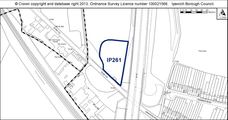
Proposed Allocation Policy DM41
|
Use(s) |
% of site |
Density of housing (H, M, L)* |
Indicative capacity |
|
Permanent site for Gypsies and Travellers providing 5 pitches |
100% |
N/A |
5 pitches |
* see Core Strategy policy DM30 for average densities.
Preferred Option 2007
N/A- new site.
Current use
Set aside farm land
Development constraints / issues
Access constraints – adequate visibility splays will need to be achieved.
Noise from the adjacent A14. Need to maintain the separation of Bramford Village from Ipswich.
(1) Site ref: IP262 (UC N/A) Former Ash Tip, Cliff Quay
Site area: 3.12ha
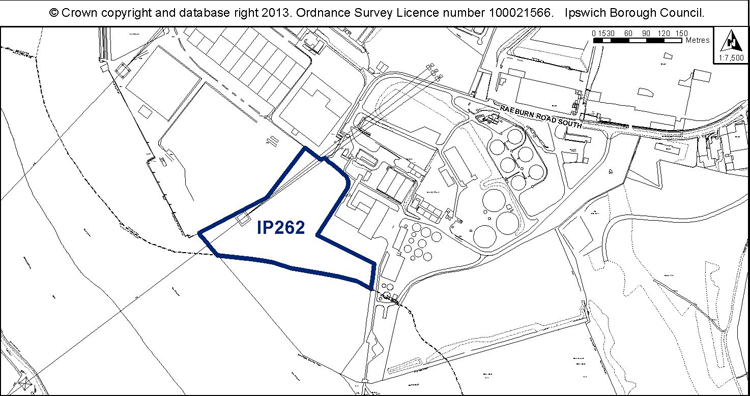
Proposed Allocation Policy DM46
|
Use(s) |
% of site |
Density of housing (H, M, L)* |
Indicative capacity |
|
Port related uses |
100% |
N/A |
N/A |
* see Core Strategy policy DM30 for average densities.
Preferred Option 2007
Site was not identified in 2007 (but was previously allocated in the 1997 Local Plan)
Current use
Vacant land.
Development constraints / issues
Close to an SPA and Ramsar Site. Odour from the sewage works.
(2) Site ref: IP263 (UC N/A) West of Bridge Street, north of the River Orwell
Site area: 0.17ha
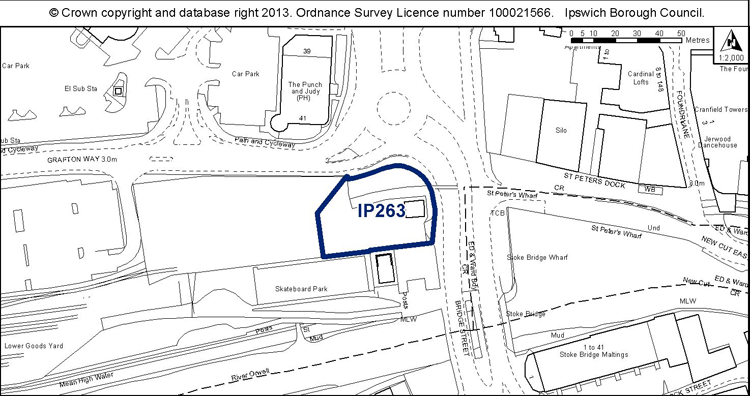
Proposed Allocation Policy DM43
|
Use(s) |
% of site |
Density of housing (H, M, L)* |
Indicative capacity |
|
Public open space |
100% |
N/A |
N/A |
* see Core Strategy policy DM30 for average densities.
Preferred Option 2007
Site was not identified in 2007 (but was previously allocated in the 1997 Local Plan)
Current use
Vacant land / temporary car park.
Development constraints / issues
In a flood zone, close to an AQMA, adjacent to a conservation area, part within an area of archaeological importance, TPO trees nearby and possible contamination.