Issues and Options for the Ipswich Local Plan Review
Issues and Options for the Ipswich Local Plan Review
Part 1 – Strategic / Cross Boundary Issues for Ipswich Borough Council and Suffolk Coastal District Council
Local Plan Review – Issues and Options for Ipswich Borough Council and Suffolk Coastal District Council within the context of the Ipswich Housing Market Area
Why are we preparing this document?
Ipswich Borough Council and Suffolk Coastal District Council are preparing new Local Plans for their areas, to look ahead to 2036. These Local Plans will either be prepared jointly, or aligned to provide an integrated spatial strategy across the two local planning authority areas. This is your first opportunity to take part in their preparation. This work is being undertaken in parallel with the Babergh and Mid Suffolk District Council Joint Local Plan.
A Local Plan sets out the level of growth which needs to be planned in an area and identifies where that growth should be located and how it should be delivered. A Local Plan also sets out planning policies used to determine planning applications.
The purpose of planning is to help achieve sustainable development. To do this, it is important that Local Plans take account of how people live their lives. This means looking at all the inter-relationships between where people live, work, are educated, do their shopping, and pursue leisure, cultural and sporting activities.
The boundary around Ipswich Borough is tightly drawn and does not include the whole of the town, for example the communities of Pinewood and Kesgrave lie outside the administrative area of Ipswich Borough. Therefore, to ensure that future development is sustainable, deliverable, supported by infrastructure and creates good quality places for people, the local planning authorities are working together to consider jointly the scale and distribution of growth needed across Ipswich Borough and Suffolk Coastal, within the Ipswich Housing Market Area (HMA).
Babergh and Mid Suffolk District Councils are also working together to prepare a new Joint Local Plan document that will detail strategic issues and the approach to development in that part of the Ipswich HMA. The timetable for its preparation is closely aligned with that of Suffolk Coastal and Ipswich and beyond this current consultation all four local authorities will be addressing the feedback and cross boundary strategic policy issues collaboratively.
For this stage, Ipswich Borough Council and Suffolk Coastal District Council are considering the strategic issues together, whilst addressing more local choices individually. Thus detailed planning matters, such as the design of development, will be addressed by each of the local planning authorities taking into account local aspirations and characteristics.
The National Planning Policy Framework (NPPF, paragraph 156) outlines the range of strategic priorities that a Local Plan should seek to address:
- The homes and jobs needed in the area;
- The provision of retail, leisure and other commercial development;
- The provision of infrastructure for transport, telecommunications, waste management, water supply, wastewater, flood risk and coastal change management, and the provision of minerals and energy (including heat);
- The provision of health, security, community and cultural infrastructure and other local facilities; and
- Climate change mitigation and adaptation, conservation and enhancement of the natural and historic environment, including landscape.
Some of these matters will be dealt with at this stage and some picked up at subsequent stages in plan preparation, as more detail emerges about the likely scale and location of growth.
This consultation aims to gather your views on the levels of growth we need to plan for over the period to 2036, and where that growth should be located.
How have we got here?
Memorandum of Understanding
In 2016, the four local planning authorities and Suffolk County Council signed a Memorandum of Understanding (MoU), which established a framework for co-operation in relation to planning for housing and employment growth across the Ipswich Housing Market Area and the Ipswich Functional Economic Area. The key objective of the MoU is to ensure that strategic policies are consistent across the local authorities and commit the parties to actions through joint or aligned Local Plan reviews, including:
- Agreeing objectively assessed housing need for the Housing Market Area,
- Agreeing objectively assessed employment need for the Functional Economic Area,
- Identifying broad locations to accommodate housing and employment growth,
- Implementing mitigation measures required under Habitats Regulations Assessment, and
- Identifying and prioritising infrastructure delivery related to housing and employment growth.
The need to continue with a joint/aligned Local Plan was reaffirmed in the Inspector's Report which considered the Ipswich Borough Council Local Plan (published January 2017). The Inspector found the Ipswich documents to be sound but highlighted the need to continue to comply with the "Duty to Cooperate" in relation to neighbouring authorities to ensure that housing and employment needs are met.
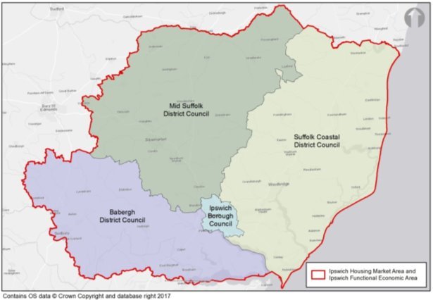
The Ipswich Housing Market Area (HMA) consists of the whole area covered by Babergh District Council, Ipswich Borough Council, Mid Suffolk and Suffolk Coastal District Councils. It was identified through the Strategic Housing Market Assessment May 2017. The IHMA is the same geography as the Ipswich Functional Economic Area (FEA). The definitions are arrived at as a result of looking at the self-containment of the area in relation to factors such as house moves and travel to work journeys.
Figure 1 the Ipswich Housing Market Area and Functional Economic Area
Ipswich Policy Area
The local authorities have a long established working relationship to consider cross boundary issues as part of the Ipswich Policy Area (IPA). The IPA focused on the town of Ipswich and numerous communities surrounding the county town.
It was largely driven by the now abolished East of England Plan. The IPA Board, through the Memorandum of Understanding, has embraced the Government's recommended approach of working on a Housing Market Area basis and planning for the whole of the four local authority areas, rather than focusing on the IPA boundary as currently defined in plans. This needs to be recognised when discussing the potential location of spatial options.
Building on the experience and cooperation of the Ipswich Policy Area, the local authorities can now continue to identify the key strategic cross boundary issues which affect all communities across the Ipswich HMA and Ipswich FEA.
Housing White Paper
The Government published the Housing White Paper "Fixing our broken housing market" in February 2017. The White Paper outlines the Government's commitment to fixing the existing housing market and introducing reforms to the plan making system. The White Paper is clear that changes are required to ensure a sustained boost to housing supply, creating efficient housing markets which match the needs and aspirations of all households and support wider economic prosperity. The need to address this serious shortage of decent and affordable housing has more recently been iterated in Saiid Javid's Secretary of State speech to the Local Government Association conference. Local authorities are challenged to meet their housing needs and where necessary work with neighbouring authorities on strategic matters to ensure these are met. The White Paper proposes increased levels of flexibility over plan structure, with strategic cross boundary issues being identified and then more detailed matters addressed through neighbourhood plans or more focused development plan documents.
Shared Evidence Base
Ahead of the first round of consultation, the local authorities have commissioned a number of joint evidence base documents which have helped to identify the issues facing communities across the Ipswich HMA and Ipswich FEA. Joint evidence is a key part of the Local Plan and underpins the joint approach to plan preparation. The following evidence has been established to provide the basis on which to identify issues.
- Strategic Housing Market Assessment (2017) – this identifies the objectively assessed housing need for the local planning authorities;
- Accommodation Needs Assessment for Gypsies, Travellers, Travelling Show People and Boat Dwellers (2017) – this identifies the number of pitches, sites and moorings which need to be planned for;
- Employment Land Needs Assessment (2016) – this identifies the minimum amount of employment land needed;
- Employment Land Supply Assessment (2017) – this updates the Needs Assessment and assesses the suitability of existing and potential employment sites;
- Retail and Commercial Leisure Needs Study (2017) for Ipswich and Suffolk Coastal – this identifies the need for additional shopping and leisure floorspace for Ipswich and Suffolk Coastal. Babergh and Mid Suffolk District Councils had already commissioned a study without Ipswich Borough Council or Suffolk Coastal District Council involvement (published in September 2015).
As issues are identified across the Ipswich HMA and Ipswich FEA, additional evidence base studies will be undertaken. Suffolk County Council as local highways authority is currently promoting the Upper Orwell Crossings project and assessing the feasibility and potential benefits of a Northern Relief Road for Ipswich. A county-wide multi-modal transport model has been developed, which will help inform options and test the impacts of the preferred scale and distribution of growth as the Local Plan evolves. Other evidence base documents and studies that the local authorities expect to be undertaken include (this list is not exhaustive):
- Landscape Character Assessment and Landscape Sensitivity Analysis;
- Water Cycle Study;
- Strategic Flood Risk Assessments;
- Whole Plan Viability;
- Design and Heritage Assessments;
- Air Quality and Transport Modelling; and
- Infrastructure Delivery Plan.
What does this document aim to do?
This Issues and Options Consultation document is intended to identify the cross boundary issues which are facing the Ipswich HMA and Ipswich FEA and the local planning authorities within it. The Issues and Options Consultation is the first stage in the process of developing a Local Plan and will be followed by further periods of consultation and engagement with the general public and interested stakeholders as detailed in the Local Development Scheme for each authority.
Further opportunities to have your say are scheduled to arise in 2018:
- First draft plan – spring 2018 (regulation 18)
- Final draft plan – autumn 2018 (regulation 19)
The Issues and Options Consultation will seek your views on issues identified through the emerging evidence base which has in many circumstances been commissioned across the wider HMA and FEA. Through the consideration of these issues, the local authorities hope to generate debate and build consensus in respect of the approach to future growth.
Ipswich Borough Council and Suffolk Coastal District Council are each consulting on a joint Part 1 which considers the strategic, cross boundary issues, alongside individual Part 2 documents that deal with local issues, specific to each authority.
How does it relate to individual local plans?
As of summer 2017, Ipswich Borough Council and Suffolk Coastal District Council are at a similar stage in the process of producing a Local Plan in that recent documents have been adopted and the Councils are committed to undertaking a Local Plan Review (or new Local Plan) over the period 2017-2019, to look ahead to 2036. Babergh and Mid Suffolk Councils are also starting a parallel, Joint Local Plan Review now.
This Issues and Options Consultation Document will begin the process of revising the current suite of documents adopted across the Ipswich HMA and Ipswich FEA.
Ipswich – population (Mid-Year Estimate) 2016 of 135,908, and an area of 40.3 sq. km/15.56 sq. miles. Ipswich is the county town of Suffolk situated on the Orwell Estuary and is a major centre of population, economic activity and growth in the Eastern Region. Train services provide access to London in just over an hour and links to Norwich, Cambridge and Peterborough, but the network also serves the East Coast and Felixstowe, all essential routes for containerised freight. Ipswich is also closely connected to the primary and trunk road network with the A12 giving access to London, the M25 and Stansted Airport and the A14 linking the Midlands and the Port of Felixstowe.
Suffolk Coastal – population (Mid-Year Estimate) 2016 of 126,000, and an area of 891.5 sq. km/344 sq. miles. The majority (around 60%) live in the larger urban areas such as the east of Ipswich area, Felixstowe and the market towns. The district contains some 48.8km of open coast. The exceptional quality of the natural, historic and built environment makes Suffolk Coastal a very special place to live and work and a popular destination for visitors and tourists from the UK and abroad. The district is made up of in excess of 100 parishes with populations ranging from a handful to several thousand people.
Babergh – population (Mid-Year Estimate) 2016 of 89,500, and an area of 596 sq. km/230 sq. miles. The main centres of population are Sudbury/Great Cornard, Hadleigh, and Pinewood in the Ipswich fringe. The district is characterised by ancient rolling farmlands and plateau lands with two Areas of Outstanding Natural Beauty: Suffolk Coast and Heaths; and Dedham Vale[1].
Mid Suffolk – population (Mid-Year Estimate) 2016 of 100,000, and an area of 858 sq. km/335 sq. miles. The main centres of population are Stowmarket, Needham Market and Eye. The district is characterised by undulating plateau claylands dissected by rolling river valleys[2].
Key Issues
The key issues facing the local authority areas of Ipswich and Suffolk Coastal have been derived from an initial analysis of baseline data and evidence set down in the Sustainability Appraisal Scoping Report. The identification of these key issues enables the baseline to be identified and helps establish the objectives in the Sustainability Appraisal Framework that will be used to assess the sustainability of alternative policy options. The table below outlines the key environmental, social and economic issues across the two authorities.
The Local Plan Review will seek to address these key issues through appropriate policies and measures of mitigation. For more detail, please refer to the Sustainability Appraisal Scoping Report which outlines these key issues further.
Social Issues
|
Suffolk Coastal |
Ipswich |
|
|
Environmental Issues
|
Suffolk Coastal |
Ipswich |
|
|
Economic Issues
|
Suffolk Coastal |
Ipswich |
|
|
|
(17) Q1: Are there any other issues that the Local Plan should consider? |
What is the vision for the Ipswich HMA and Ipswich FEA?
New Anglia Strategic Economic Plan – "We are ambitious for Norfolk and Suffolk and our goal is to firmly establish the New Anglia economy as a centre for global talent and business excellence. We are targeting by 2026:
- 95,000 more jobs – which is 50% higher than forecast,
- 10,000 new businesses – which is more than double previous trends,
- 117,000 new homes – which is 30% higher than previous delivery,
- Increased productivity to equal the national average – increasing Gross Value Added from £36,000 a job to £40,000 on present numbers.
A new economic strategy is due to be published by the New Anglia Local Enterprise Partnership in October 2017.
Ipswich Borough Council Top Priorities – "Together we are building a better Ipswich." Three top priorities will continue to be:
- Protecting frontline council services,
- Building quality and affordable homes for Ipswich people,
- Bringing new jobs and investment to Ipswich.
Additional priorities include:
Priority 1 A Strong Ipswich Economy
Priority 2 A Sustainable Environment
Priority 3 An Enjoyable Place to Live, Work and Study
Priority 4 A Healthy Community
Priority 5 Quality Homes for All
Priority 6 Safe Communities
Priority 7 An Efficient and Effective Council
Ipswich Vision – The Ipswich Vision is to create East Anglia's Waterfront Town and demands:
- A town centre that will attract new investment,
- A town centre that is true to its history,
- A town centre that is bold and ambitious,
- A town centre that recognises the need for change,
- A town centre that will excite those who visit it,
- A town centre that will appeal to those beyond its immediate catchment.
If it is to succeed, the Ipswich Vision, as with any other viable vision, must be connected and anchored by three aspects: Historical, Physical and Emotional.
Our Vision aims to set out a process by which Ipswich can further deliver on its ambition to become a unique and sought-after destination as 'East Anglia's Waterfront Town'.
Suffolk Coastal (East Suffolk) Vision – "Maintain and sustainably improve the quality of life for everyone growing up, living in, working in and visiting East Suffolk." The vision will be achieved by adopting a three-pronged strategy:
- Enabling Communities,
- Economic Growth,
- Financial Self Sufficiency.
Babergh Vision – "To create an environment where individuals, families, communities and businesses can thrive and flourish."
Mid Suffolk Vision – "We will work to ensure the economy, environment and communities in Mid Suffolk continue to thrive and achieve their full potential."
The priorities for the Babergh and Mid Suffolk Visions are joint and are:
- Economy and Environment;
- Housing; and
- Strong and Healthy Communities.
Although the vision and priorities are different across the Ipswich HMA and Ipswich FEA, they broadly accord with the higher level priorities identified across the New Anglia Local Enterprise Partnership. These also reflect the key principles of the National Planning Policy Framework and provide a sound basis on which to plan for future growth collectively.
|
(13) Q2: What are the advantages of your area that should be protected through local plans? (12) Q3: What are the disadvantages of your area that the local plans could try to address through the way land is used or developed? (26) Q4: What are the key priorities you would like to be addressed by 2036 – in the places across Ipswich and Suffolk Coastal where you live, work or study? (8) Q5: What is your vision for the Ipswich HMA and Ipswich FEA by 2036? |
A How much growth? The number of homes and jobs that should be planned for
Homes
Ipswich Borough Council and Suffolk Coastal District Council both have adopted Local Plans in place which set out housing and employment growth targets. Some of the targets pre-date the publication of the National Planning Policy Framework and the adopted Local Plan periods are different – Ipswich look to 2031 and Suffolk Coastal to 2027.
There is now an opportunity, through aligning our local plans, to base each area's local plan review on the same evidence base looking to 2036 and considering the Ipswich HMA as a whole.
The National Planning Policy Framework requires local planning authorities to ensure that local plans meet the full, objectively assessed housing need in the housing market area. It also requires them to plan proactively to meet the development needs of business.
The Objectively Assessed Housing Need (OAN) for the Ipswich HMA and individual local planning authorities has been assessed through a Strategic Housing Market Assessment or 'SHMA' report, which was published in May 2017. The SHMA report takes into account population and household projections, market signals and jobs forecasts to ensure that housing is not considered in isolation from economic factors. It also considers the relationship with London and whether additional growth needs to be accommodated.
The population of the Ipswich HMA is forecast to grow, as a result of both natural change and migration (of people moving from elsewhere within the UK and abroad). The forecast population growth from 2014 to 2036 is 42,692 (Table 1 below), which is translated into a need for 39,302 additional dwellings across the housing market area between 2014 and 2036 (Table 2 opposite). The breakdown below in Table 1 shows the national (ONS) projected population figures across the Ipswich HMA (Table 5.1 from the published SHMA). It is based on the assumption that current trends will continue.
Table 1 Ipswich HMA sub-national population projections 2014-36 (SHMA/ONS)
|
LPA |
2014 population |
Natural change |
Net migration |
Total change |
2036 population |
|
Ipswich |
134,966 |
15,294 |
-2,000 |
13,294 |
148,260 |
|
Babergh |
88,845 |
-7,325 |
15,410 |
8,086 |
96,931 |
|
Mid Suffolk |
99,121 |
-3,578 |
16,631 |
13,053 |
112,174 |
|
Suffolk Coastal |
124,776 |
-13,241 |
21,500 |
8,259 |
133,035 |
|
IHMA Total |
447,708 |
-8,850 |
51,541 |
42,692 |
490,400 |
Population and household numbers are growing. Population increases through natural change (births exceeding deaths), internal migration within the UK and international migration. The number of households increases as a result of the population growth and other social trends, such as people choosing to live alone, living longer or increased divorce rates. If insufficient housing is provided, it could push up prices and make affordability worse, contribute to overcrowding and mean that local businesses cannot recruit enough workers.
The OAN assessment summary is shown in Table 2 below for the period 2014 to 2036.
Table 2 Objectively Assessed Housing Need (OAN) in the Ipswich HMA
|
|
Dwellings per annum (dpa) |
Total dwellings |
Market signals uplift (%) |
Market signal uplift (dwellings) |
Future jobs uplift (dwellings) |
OAN (dwellings) |
OAN (dpa) |
|
Ipswich |
472 |
10,382 |
10% |
1,038 |
838 |
11,420 |
519 |
|
Babergh |
309 |
6,799 |
15% |
1,020 |
- |
7,820 |
355 |
|
Mid Suffolk |
411 |
9,046 |
10% |
905 |
- |
9,951 |
452 |
|
Suffolk Coastal |
400 |
8,792 |
15% |
1,319 |
- |
10,111 |
460 |
|
IHMA Total |
1,592 |
35,019 |
0.5 |
4,282 |
838 |
39,302 |
1,786 |
The Objectively Assessed Need figures identified through the SHMA report are similar to the figures included within existing Local Plan documents (Ipswich Borough Council 489 dpa, Suffolk Coastal District Council 465pa). The Objectively Assessed Need is the starting point for what the local plans have to seek to provide for.
The scenarios outlined below reflect these figures and therefore do not include a scenario which is lower than the requirements set out in the evidence base. The NPPF is clear that local planning authorities should meet their objectively assessed need unless any adverse impacts of doing so would significantly and demonstrably outweigh the benefits, when assessed against the policies in the NPPF taken as a whole. This consultation period provides the opportunity to consider whether or not the Councils should consider setting a lower figure in respect of housing.
The OAN figure in Table 2 above is a requirement calculated from a 2014 base date, but some dwellings have been built or granted permission between 1st April 2014 and 31st March 2017. Also, some land is already identified for housing through the adopted Ipswich Borough Council and Suffolk Coastal District Council Local Plans. Therefore, Table 3 below identifies the number of dwellings that need to be delivered on land not currently identified. The figures are correct as at 31st March 2017.
Table 3 Objectively Assessed Housing Need (OAN) and committed housing land supply
|
Ipswich Borough Council |
Suffolk Coastal District Council[3] |
|
11,420 dwellings (OAN 2014-2036)
|
10,111 dwellings (OAN 2014-2036)
|
|
3,131 dwellings to be delivered on land not currently identified |
1,645 dwellings to be delivered on land not currently identified. |
a This is a discounted number (1,229 minus a 10% discount for slippage).
b This figure is also discounted by 10% to allow for slippage (660 without discount).
c Note - this supply figure excludes windfall allowance. It includes 3,250 dwellings at Ipswich Garden Suburb.
Therefore, land will need to be found through the Local Plan reviews to deliver around an additional 4,776 dwellings from 2017 to 2036, in order to meet the housing need of Ipswich and Suffolk Coastal. Land availability assessments being undertaken in both local authority areas may meet some of this shortfall. In addition, a number of dwellings have historically been delivered through windfall sites, which are sites not currently identified through the planning process. However, in the case of Ipswich, it is anticipated that there would still be a shortfall of around 2,000 to 2,500 dwellings.
National Planning Policy calls for a Housing Market Area wide approach to identifying and meeting objectively assessed housing need. If land is not available in one part of the Housing Market Area to meet it, for example because of administrative boundaries or environmental constraints, then options across the whole Housing Market Area should be considered. It is not the case that any need not planned for within Ipswich Borough would automatically have to be accommodated within Suffolk Coastal. This would need to be considered across the whole Housing Market Area.
Jobs
For jobs, the Councils have three key evidence documents: jobs calculations produced using the East of England Forecasting Model (EEFM) (August 2016), and two studies: the Employment Land Needs Assessment (2016) and Employment Land Supply Assessment (2017). The studies consider the needs of the Ipswich Functional Economic Area (FEA) which equates to the Ipswich Housing Market Area. Table 4 below sets out the jobs projections for the Ipswich FEA.
Table 4 EEFM 2016 Baseline Jobs Projections
|
Location |
Total number of jobs |
Change 2014-2036 |
||
|
|
2014 |
2036 |
No |
% |
|
Babergh |
39,005 |
42,645 |
3,640 |
9.3 |
|
Ipswich |
75,195 |
94,235 |
19,040 |
25.3 |
|
Mid Suffolk |
43,895 |
50,345 |
6,450 |
14.7 |
|
Suffolk Coastal |
60,510 |
68,450 |
7,940 |
13.1 |
|
Ipswich Functional Economic Area |
218,605 |
255,675 |
37,070 |
17.0 |
The total number of jobs in the Ipswich Functional Economic Area (FEA) is expected to grow by 37,070 over the 22 years to 2036, equivalent to an increase of 1,685 jobs per year. In Suffolk Coastal and Ipswich, the jobs growth total is 26,980. Ipswich is expected to drive the majority (51%) of this growth, followed by Suffolk Coastal, Mid Suffolk and Babergh. The EEFM considers jobs in all sectors, including shops, schools, factories, offices, hospitals and cinemas.
The Employment Land Supply Assessment (ELSA) identifies sectors which are forecast to grow strongly across the Ipswich FEA: business and professional services, computing and technology, construction, education, health and care, hospitality and leisure, retail, transport and logistics and wholesale and distribution.
The Employment Needs and Land Supply Assessments focus on uses known as 'B' class uses. B class uses include offices, light industrial workshops, factories and warehousing and distribution centres.
Within the Ipswich FEA there are a number of distinct economic geographies and commercial property market sub-areas including:
• the Felixstowe/A14 Corridor (characterised by a high concentration of distribution related activities linked to shipping and sea freight);
• the wider Ipswich market area (comprising Ipswich town centre, edge of centre and out of centre business and industrial parks as well as the nearby settlements including Great Blakenham and Claydon);
• the A140 Corridor (connecting Mid Suffolk locations such as Eye and Mendlesham to Norwich in the north and the A14 to the south); and
- the area's other key route, the A12 corridor, is not characterised by the same level of movement and flow of demand. There is limited synergy between Colchester, Ipswich and Waveney in commercial property market terms, but the A12 corridor is locally significant for example to serve the communities of Saxmundham and coastal locations.
In employment terms, the main sectors are public administration, health and education; retail and wholesale; and professional, business and employment services. Ipswich accommodates the largest number and proportion of jobs, equivalent to 34% of all employment in the Ipswich FEA in 2014. The majority of businesses operating in the Ipswich FEA are small firms employing between 0 and 4 workers. Suffolk Coastal has the highest number of enterprises, while Ipswich accommodates fewer but larger firms.
Whilst the rate of business growth has lagged behind regional and national averages in recent years, the number of jobs has increased across the Ipswich FEA. Ipswich itself has seen the lowest overall level of growth in jobs. The main increase in jobs across the Ipswich FEA has been focused in the professional, business and employment services, accommodation and food services and manufacturing sectors.
Floorspace and land requirements have been calculated based upon the EEFM jobs growth forecasts, using ratios which reflect local circumstances to convert jobs projections into land estimates.
The Employment Land Supply Assessment identifies the baseline net land requirements for B class uses from 2014 to 2036 as shown in Table 5 below.
Table 5 EEFM Baseline Net Land Requirements 2014 – 2036 in the Ipswich FEA.
|
Use Class |
Ipswich Functional Economic Area (ha) |
||||
|
Babergh |
Ipswich |
Mid Suffolk |
Suffolk Coastal |
Total IFEA |
|
|
Offices (B1a/B1b) |
8.1 |
13.0 |
9.1 |
10.6 |
40.8 |
|
Industrial (B1c/B2/B8) |
-5.2 |
15.3 |
0.3 |
3.8 |
14.2 |
|
All B Uses |
2.9 |
28.3 |
9.4 |
14.4 |
55.0 |
It should be noted that the figures are net requirements, which make an allowance for normal market vacancy rates, but do not allow for future replacement of losses or apply a safety margin – i.e. the 'gross' requirement used for planning purposes. They represent a starting point for the amount of employment land that may be needed. Local planning authorities may choose to allocate or safeguard more land, in order to ensure a range of sizes and locations of sites available for development, to support key economic drivers such as the Port of Felixstowe and clusters of similar businesses in certain locations or to reflect policy aspirations to deliver more jobs.
Growth Scenarios
In this consultation document, the local authorities identify a number of scenarios to consider the scale of housing and jobs growth between 2014 and 2036 and options for where development should be broadly located.
The headline scenario figures set out below do not take into account the housing completions and permissions between 2014 and 2017 and land allocations set out in Table 3. Therefore, with each scenario an illustration is also provided to show what the 'residual' figures would be if the housing development already delivered or in the pipeline is factored in.
Scenario A Baseline
Trend based scenario – Objectively Assessed Need (OAN) for housing and East of England Forecasting Model (EEFM) jobs forecasts
- 21,531 dwellings (11,420 in Ipswich and 10,111 in
Suffolk Coastal)
- 4,776 dwellings would be the residual figure to be planned for
- 26,980 jobs 2014 to 2036 (19,040 in Ipswich and 7,940 in Suffolk Coastal)
This scenario is based on the continuation of recent trends and modelling forecasts. In respect of housing growth, the official projections from the Office of National Statistics provide the starting point for consideration of housing requirements across the local authorities. Demographic forecasts are based on changes to birth and death rates as well as migration trends and the reduction in the number of people per household. The growth in households is primarily expected to be driven by those in the over 65 age bracket which will result in a need for additional people who are economically active across the area to support the economy across the area. For the scale of jobs growth, the economic trend-based forecasts of the East of England Forecasting Model have been used.
Scenario B Medium Increase in Growth
Policy-led scenario for significant economic growth
- 25,837 dwellings (OAN plus 20%)
- 9,082 dwellings would be the residual figure to be planned for
- 32,376 jobs 2014 to 2036 (trend plus 20%)
This scenario seeks to increase job targets based on an aspiration for significant economic development to take place across the Functional Economic Area. Significant economic development opportunities in the form of a new nuclear power station at Sizewell, offshore energy industries and further support for established key sectors such as the Port of Felixstowe or ICT Technologies could bring about a further increase in jobs. The New Anglia LEP identifies these opportunities as key growth areas with the potential to host high levels of activity and growth. Therefore, it is anticipated that many of these job opportunities could come forward outside the Ipswich Borough boundary but would support the economic success of the Ipswich Functional Economic Area.
With more jobs would come the need for some additional housing, to ensure that there is sufficient labour available to support the significant economic development opportunities. However, in the case of Sizewell, it is acknowledged that purpose built campus style housing will be provided to accommodate the needs of construction of staff. In this scenario the number of people economically active will increase as a result of the significant economic developments that come forward, but the area will still see an increase in the number of people not economically active due to the ageing population.
In an economic growth-led scenario, some additional work would be needed to ensure that the growth in new homes provision would be sufficient to avoid constraining the labour supply, therefore the OAN plus 20% is indicative only.
Scenario C High Increase in Growth
Infrastructure delivery-led scenario
- 30,143 dwellings (OAN plus 40%)
- 13,388 dwellings would be the residual figure to be planned for
- 32,376 jobs 2014 to 2036 (trend plus 20%)
The Norfolk and Suffolk Devolution Agreement June 2016 set out a commitment to 'substantially increase housing delivery.' It undertook to plan for 200,000 homes over the longer period of local plans across Norfolk and Suffolk (2012-2036) and the delivery of significant infrastructure needed to support the increase of new homes. Whilst the Devolution Deal has not been resolved, the ambitious housing growth scenario which it set out is one which needs to be explored.
The additional 200,000 homes translated into some 95,000 for Suffolk, which represents substantial uplift over objectively assessed need across the county. Ipswich as the county town and the communities surrounding it are well placed to benefit from the substantial uplift in targets. Ipswich and the communities surrounding the town are fundamental to the overall prosperity of the county and an ambitious uplift across the Ipswich HMA would help deliver housing in locations well related to the county town and would go some way towards meeting the County aspiration.
This scenario is intended to deliver key infrastructure projects across the Ipswich HMA and help meet the Government's objective to deliver more housing. An infrastructure-led scenario reflects the opportunity to create a more successful and prosperous area which benefits from improved infrastructure supporting ambitious uplift in the housing requirement. In this scenario the increase in housing requirement reflects the objectively assessed housing need plus additional housing that could be delivered on land opened up through infrastructure improvements, for example an Ipswich northern route.
An issue in the Ipswich area is the closure of the Orwell Bridge for safety reasons in bad weather. This causes severe congestion in the local road network, especially through Ipswich, as local and through traffic converges on the town to find alternative east-west routes. Should the Local Plan Review seek to address this?
The large sites opened up by road schemes can also attain the critical mass to deliver more health, education and community infrastructure directly on site, whereas smaller developments contribute financially to off-site facilities through Community Infrastructure Levy or Section 106 agreements.
The SHMA suggests that Ipswich Borough Council may want to consider whether the OAN for Ipswich Borough should be uplifted to help provide more affordable housing to meet the identified need. This scenario would potentially address any uplift required depending on where the increased housing would be located in relation to Ipswich Borough. For example, to meet the affordable housing need, any additional affordable housing would need to be concentrated close to Ipswich Borough. It is recognised that social rented housing is a key component of the affordable housing mix.
|
(19) Q6: Which growth scenario should we plan for across the Ipswich Housing Market Area? (7) Q7: Do you have evidence to suggest that the housing and/or jobs targets should be different from the forecasts or scenarios outlined above – either higher or lower? (11) Q8: Would communities be prepared to accept more growth if that growth meant that significant new or enhanced infrastructure could be provided? (10) Q9: What key pieces of transport infrastructure should be sought? Would it be roads such as an Ipswich northern route, or sustainable transport infrastructure (public transport, park and ride, cycling), or both? (6) Q10: Should the Local Plan Review seek to address the issue of temporary closure of the Orwell Bridge by planning for a scale of development that can help to deliver infrastructure? (9) Q11: Do you agree that providing a high growth scenario would help to deliver the affordable housing required? (3) Q12: Are there alternative scenarios which should be considered? |
B Where should the growth go?
The local authorities also need to consider the most suitable locations and distribution for this growth across the Ipswich HMA and Ipswich FEA.
The following options have been published to assist with the debate about where future growth should be located and the scale of development. It may be that, following this consultation, a different option emerges or a combination of the options may be preferred. The questions at the end of the section invite views on all the options, which are purposely posed in order to explore a range of possibilities.
The options primarily focus on the distribution of housing growth and we pose the question about whether we should be aligning the spatial distribution of housing and jobs growth by delivering it in the same locations. We also seek to elicit your views on whether growth should take place in specific locations in order to deliver infrastructure.
The Ipswich Housing Market Area
This Issues and Options consultation document relates to the areas administered by Ipswich Borough and Suffolk Coastal District Councils. However, national planning policy encourages local planning authorities to plan to meet housing needs across a whole Housing Market Area.
Specific detail around the options for Babergh and Mid Suffolk Districts is contained within their Joint Local Plan, which is subject to public consultation at the same time as this document.
The distribution of growth across Ipswich Borough Council and Suffolk Coastal District will contribute towards improving the economic, social and environmental characteristics of the area. This will be tested by a sustainability appraisal that will be carried out as alternative options are assessed, narrowed down and firmed up. Alongside this document, a joint framework for the sustainability appraisal in the form of a Scoping Report for Ipswich Borough Council and Suffolk Coastal District Council is available for comment. Preparation of the Sustainability Appraisal has been undertaken in partnership with Babergh and Mid Suffolk District Councils, who published their Sustainability Appraisal Scoping Report in March 2017.
Ipswich Borough Council
Alternative delivery options
There are limited spatial options available to Ipswich, because of the tightly drawn Borough boundary. In addition, housing delivery in the Borough has been below target since 2009/10 following the recession, reflecting a weak housing market for new build development. A number of options are outlined below.
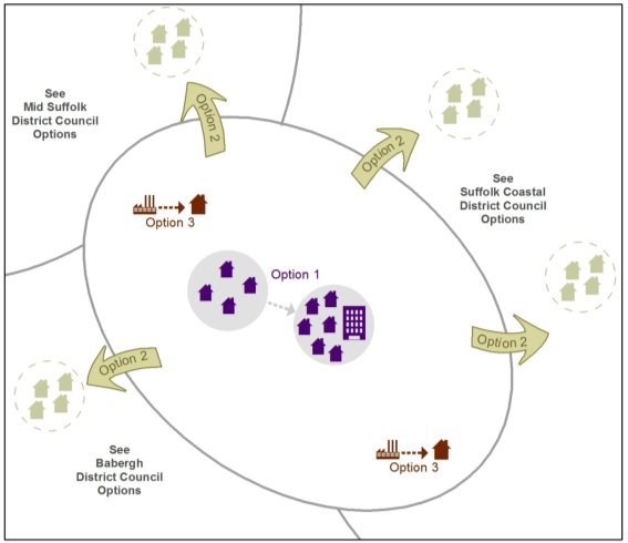
Option 1 – higher-density urban regeneration
The Council tested a strategy of urban concentration and higher density housing development in its preferred options documents for the Core Strategy and Policies, IP-One Area Action Plan and Site Allocations and Policies documents prepared in November 2007. The strategy was subject to public consultation between January and March 2008. A number of the sites identified were subsequently either unavailable for development or the densities proposed were too high for their surroundings. In addition, economic conditions worsened in 2008, resulting in higher density schemes becoming economically unviable to deliver and leaving 'stalled' high density developments incomplete on the Ipswich Waterfront. The emerging 2011 Core Strategy responded to this by reducing the highest residential density requirement from at least 110 dwellings per hectare (dph) with an average of 165dph at preferred options stage, to at least 90dph with an average of 110dph in the adopted 2011 plan (policy DM30).
In February 2017, Ipswich Borough Council adopted a new Local Plan. The approach to residential density has been eased further in this plan to reflect what is deliverable on the ground. The highest density set out in policy DM30 remains at least 90 dwellings per hectare (dph) but the average has been removed. Densities in new schemes have generally not returned to their pre-recession levels in Ipswich as shown in Figure 2 below. The exceptional 'spike' in 2014/15 was caused by completions at the Stoke Quay development, consisting mainly of apartments, which was only viable as a result of gap funding from the Homes and Communities Agency.
Figure 2 Average net density of residential completions in Ipswich (dwellings per hectare)
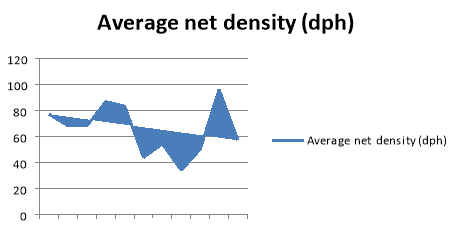
Note: completions include new build and conversions on all developments of 10 dwellings or more
Option 2 – increased development beyond the Borough boundary
A second alternative strategy is to locate more housing developments outside the Borough in Suffolk Coastal, Babergh and Mid Suffolk Districts. Within this strategy, there would be locational choices and they are developed further in the options which follow. For example, development could be located within communities around Ipswich, or distributed across the more extensive Ipswich HMA, or it could be delivered through a new settlement somewhere within the Ipswich HMA.
Some parishes around Ipswich form continuous development on the edge of the Borough, for example Purdis Farm in Suffolk Coastal and Pinewood in Babergh. Others are separated from the Borough by countryside, for example Rushmere in Suffolk Coastal. Ipswich and Suffolk Coastal Local Plans since at least 1997 have pursued a policy of maintaining separation of the villages from the town, in order to maintain their own identity.
The Ipswich HMA is more extensive but areas within it still relate to Ipswich as part of the housing market area and the functional economic area. Here the distribution options could fulfil other planning objectives, such as supporting growth in the market towns.
Decision making for the location and delivery of any development outside Ipswich Borough will depend on the form of any future Local Plan document. For example, if there is a joint plan for the four local authorities, the decision will be a joint one. If it is not a joint plan, it will fall to the individual districts. Any plans will be based on an agreed distribution that will be informed by the Sustainability Appraisal and Local Plan Options process.
Option 3 – changing the use of existing land in the Borough to housing
As a result of the tightly drawn Borough boundary around Ipswich, the supply of land available within it for residential use in future is limited. The main potential sources are the remaining countryside around the edge of the Borough or land currently protected for employment use.
In relation to land currently identified through the Local Plan as countryside, the Planning Inspector who examined the adopted Ipswich Local Plan required the Council to modify the plan to provide for such land to come forward for residential development if certain requirements are met. The adopted Ipswich Local Plan already includes a 'windfall allowance' in the housing land supply calculation in reflection of such policies, which may allow sites not currently allocated for development to come forward. However, what has not been considered to date is whether there are cross boundary opportunities on the edge of Ipswich to identify larger areas of land for development linked to significant transport infrastructure improvements.
Some sites identified currently by the Local Plan as countryside are small, difficult to access or within or adjacent to the Area of Outstanding Natural Beauty. Some are adjacent to the A14 and therefore noise could be a constraint on residential development.
The Borough's employment land supply has been assessed in terms of quality and quantity through the Employment Land Supply Assessment (ELSA) (July 2017). Ipswich has a challenging jobs delivery forecast of 19,040 jobs between 2014 and 2036. The study concludes that the starting point for net employment land need in the Borough should be around half the land area that the current Local plan allocates. This does not take account of the need to provide a range of sites of different sizes in different locations, and it is a projection of economic trends rather than reflecting any growth ambitions.
The Council's own monitoring of the Employment Areas such as Whitehouse and Ransomes Europark shows that occupancy rates have increased. The areas provide an important source of land and premises for local businesses and offer sites away from sensitive uses such as homes, whose occupants could be disturbed for example by 24 hour operation. It is, therefore, unlikely that changing land from employment to housing use within the Borough would deliver sufficient land to accommodate the Objectively Assessed Need for housing in full. However, given the large strategic employment allocations at the Ransomes Europark extension in Suffolk Coastal and the Sproughton Enterprise Park (former Sugar Beet Factory site) in Babergh it may be that other smaller employment sites could be used for housing.
Other possible sources of land
The Borough contains a range of protected open spaces, from country parks to sports pitches to allotments. The Council considers that these are essential for the health and wellbeing of residents, the town's biodiversity and wildlife network, climate change mitigation and adaptation and to create an attractive environment to encourage investment. The Ipswich Public Open Space Supplementary Planning Document maps open space provision by ward according to the Borough's adopted provision standards. It shows that there are deficits in provision of:
- parks and gardens across northern Ipswich away from the major parks of Christchurch, Holywells and Chantry;
- informal amenity open space across southern Ipswich except Priory Heath;
- natural and semi-natural greenspace everywhere except the south of the Borough near Orwell Country Park and Belstead Brook;
- children's play space in central and northern areas; and
- allotments in central and eastern areas.
Therefore, is it not considered realistic to release large areas of protected open spaces within the Borough to residential development. This does not mean that development on small open spaces or small parts of larger open spaces would not be considered on their merits. However, protected open space is not considered a significant source of housing land supply.
The diagram below shows the options 1 to 3 for Ipswich Borough Council.
Figure 3 Options for accommodating Ipswich growth
Suffolk Coastal District Council
The Core Strategy focuses 51% of the expected housing growth towards the Major Centres east of Ipswich and Felixstowe/Walton and the Trimley Villages and a further 19% spread across the Market Towns. The majority of growth and development is therefore expected in the largest settlements with limited development across the rural parts of the district considered to be countryside communities.
The Local Plan Review provides the opportunity to reconsider this distribution and identify a distribution across the district and potentially wider, which enables successful communities to develop. National policies state that development should be distributed in a way which reduces the need to travel, promotes regeneration and supports existing services and facilities.
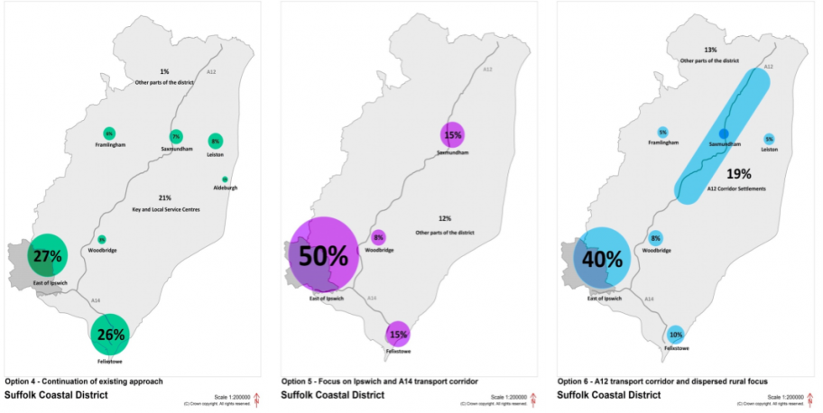
A number of potential distributions have been identified as listed below (as shown in Figure 4):
Option 4 - Continuation of existing approach
This distribution is based on the monitoring of delivery across the district since the adoption of the Core Strategy. There are slight variations from the Core Strategy distribution but it still seeks to continue the approach which focuses on the communities around Ipswich, Felixstowe and the Trimley Villages and the Market Towns. The existing policy was adopted by the Core Strategy in 2013 which introduced a settlement hierarchy focused on housing, employment and retail. Each settlement was judged against services and facilities found within it and then separated into a settlement hierarchy which guided the scale of development appropriate to each tier in respect of Housing, Employment and Retail needs.
The existing settlement hierarchy limits the scale of development in the settlements with few or minimal services which has led to development opportunities in these areas being severely restricted. The restrictive nature of the hierarchy results in some areas not receiving any type of development apart from in exceptional circumstances, which places a greater burden on other parts of the district.
Option 5 - Focus on Ipswich and A14 transport corridor
This distribution seeks to direct a larger proportion of growth to areas well related to Ipswich and the A14 transport corridor such as Felixstowe. Ipswich and the A14 transport corridor which serves the Port of Felixstowe are key contributors to the economic health of the district and supporting development in these locations will have a positive impact on the local, regional and national economy.
Focusing the development in the locations well related to Ipswich and the A14 will reinforce the links across the administrative boundaries of Ipswich and Suffolk Coastal as well as supporting the County Town of Suffolk through increased focus of future growth. A greater focus on the settlements geographically well related to Ipswich can help deliver larger scale sites and infrastructure projects to reduce pressure on existing services and facilities. Concentrating development in locations well related to the A14 transport corridor reflects the economic need for efficient movements of people and vehicles between locations and makes the most of road and transport links to locations outside of the Housing Market Area, such as Bury St Edmunds, Cambridge and Colchester.
Limited development is proposed in Saxmundham and Woodbridge to further boost rail connections between these settlements and Ipswich, as well as providing an alternative location for development on a strategic scale. Under this option, limited development is expected in the rural areas of Suffolk Coastal.
Option 6 - A12 transport corridor and dispersed rural focus
This distribution seeks to spread more development across the rural parts of the district but with a focus on those communities well related to the A12 corridor such as Saxmundham, Wickham Market and Yoxford. Promoting development well related to the A12 corridor could promote further opportunities to improve road and rail connections between Ipswich and Lowestoft.
Identifying and encouraging a level of development in the settlements which the A12 passes close to could help to address site specific issues and concerns through direct mitigation.
Encouraging a large scale of development across the rural areas can provide further opportunities for new growth to support the limited services and facilities in the rural parts of the district. A greater dispersal of sites will mean that more settlements are encouraged to take future development, of a scale appropriate to each community. Increasing the scale of development in the rural areas will help to sustain existing rural communities which in certain parts of the district are becoming popular with tourists and second home owners.
Figure 4 Potential Housing Distribution Options in Suffolk Coastal
(See Appendix 1 at the end of Part 1 for indicative housing numbers for Options 4, 5 and 6 and the alternative levels of growth.
|
(18) Q13: Which distribution options do you think would be most appropriate to take forward? (5) Q14: Are there any other distribution options that the Councils should consider, including across the whole of the Ipswich Housing Market Area? (6) Q15: Should the spatial distribution of jobs growth align with housing growth or should we take a different approach which focuses on improving accessibility between homes and work places? (5) Q16: Do you have evidence which indicates that building at higher densities in Ipswich and Suffolk Coastal would be viable financially? (16) Q17: Should the policy approach of maintaining the physical separation of villages from Ipswich be continued or should infill in gaps between settlements be considered a source of housing land? (11) Q18: If development cannot be accommodated within Ipswich, should it be focused within the communities close to Ipswich or distributed within the larger Ipswich Housing Market Area? What criteria should guide its location? (10) Q19: Should Ipswich switch employment land to housing use, even though the Borough has a high jobs target? Where should the Council prioritise protecting employment land? (12) Q20: Is there other land within Ipswich Borough which should be considered for residential development? Is the approach to protecting open space the right one? |
Gypsies, Travellers, Travelling Showpeople and Boat Dwellers
Alongside the Strategic Housing Market Assessment, a Gypsy, Traveller, Travelling Showpeople and Boat Dwellers' Accommodation Needs Assessment (ANA) has been published in May 2017 for Babergh, Ipswich, Mid Suffolk, Suffolk Coastal and Waveney Councils.
In respect of Gypsies and Travellers, the ANA identifies a need for two to three short-stay sites within the study area which will be addressed within Suffolk. In addition the ANA identifies a need in Ipswich for a further 27 residential pitches and in Suffolk Coastal for a further 15 residential pitches between 2016 and 2036.
A need for two pitches for travelling showpeople is identified within Suffolk Coastal and for 17 permanent residential moorings.
|
(2) Q21: Where do you think the most appropriate locations are to meet this need? |
C The provision of retail and leisure development
National trends
Retailing has changed over the last 50 years from post-war redevelopment in town centres, through the emergence of the out-of-town retail warehouse parks and regional shopping malls to online 'e-tailing'. Historically the retail sector has experienced considerable expenditure growth because of factors such as growing disposable income, the availability of credit and a general increase in the standard of living. However, recent economic conditions have had a clear impact on retail spending; spending per person on convenience goods (food) has decreased in recent years.
Shoppers have been increasingly prepared to travel in order to access a greater choice of shops and leisure facilities available in larger towns and cities. As a result, some smaller towns have fared less well. Retailers meanwhile have focused their investments on large flagship stores in strategic locations. Out-of-centre retail parks with free car parking and lower rents have attracted some traditional town centre retailers such as Next and John Lewis.
In the fast food sector, there is an increasing preference by operators for 'drive-thru' restaurants rather than town centre outlets. Food shopping has seen a turn away from the use of food superstores towards discounters and more frequent, smaller shopping trips. The big food operators have responded by developing smaller store formats.
These changes can combine to impact significantly on medium sized and smaller town centres. However, district and local centres are generally less affected by these trends and retain their attraction for day-to-day top up shopping.
Town centres
The NPPF is clear that town centres provide a wide variety of uses and support a range of retail, leisure and commercial opportunities. Planning policies should be positive, promote competitive town centre environments and set out policies for the management and growth of centres over the plan period. New retail, leisure and office development should be directed towards town centres as the first choice location, then edge of centre sites and only to accessible out-of-centre sites if there are no suitable sites in or on the edge of centres.
Across the Ipswich HMA and Ipswich FEA the various town and district centres cater for the everyday needs of residents, businesses and visitors and this contribution is to be reflected as part of the Local Plan Review. Town centres need to be attractive and welcome places for people to use for a variety of purposes and the Local Plan Review has a key role to play in promoting and supporting these locations.
Ipswich performs a key role as the County Town and is the centre for retail, leisure and commercial activities within the Housing Market Area, as well as a hub for public transport services. It's 'venuescore' national rank as a retail centre has improved from 67th place in 2009 to 63rd in 2015/16, reflecting the presence of national multiples. It remains the third strongest centre in the region behind Norwich and Cambridge. The town centre has seen some significant recent investment, particularly in the two shopping malls: Sailmakers has seen a refurbishment and re-branding, whilst the Buttermarket Centre has seen retail space given over to cinema and restaurant uses.
This reflects the pressures on town centres to diversify their offer and provide more leisure activities, in order to counter the effects of some of the national retail trends by distinguishing themselves from competing venues such as out-of-centre retail parks, and encouraging visitors to spend more time relaxing, eating out or meeting friends for example.
Ipswich Town Centre has come under land use pressure for a wider variety of uses as well as competition from out of town developments such as Martlesham and smaller urban settlements such as Felixstowe, Stowmarket and Sudbury and market towns generally.
Overall, Ipswich town centre is performing reasonably well, however some specific issues which need to be addressed are:
- finding new occupiers or uses for vacant units, for example the former BHS;
- attracting higher brand retailers and more food and drink operators;
- providing larger shop units to meet modern needs;
- improving pedestrian linkages and parts of the public realm; and
- controlling further out of centre retail and leisure development.
Many of these are detailed issues to be considered through the Part 2 Issues and Options Report. However, the relationship between Ipswich town centre and out of centre retail parks around the town such as Copdock Retail Park, Futura Park and Martlesham Heath is a strategic issue.
In Suffolk Coastal there are six town centres: Woodbridge, Felixstowe, Saxmundham, Framlingham, Leiston and Aldeburgh, of which Felixstowe is the largest. The centres display strong vitality and viability and several also have a strong tourism offer which attracts visitors. However some issues which need to be addressed in relation to these centres are as follows:
- The relationship with out of centre shopping, e.g. between Woodridge and Martlesham Heath;
- Limited opportunities for centres to grow;
- Low levels of leisure service provision, particularly food and drink; and
- The need for better pedestrian links e.g. to the station in Saxmundham, the river in Woodbridge, and the link between Felixstowe town centre and the seafront.
Retail floorspace
The emerging Ipswich and Suffolk Coastal Retail and Leisure Needs Study 2017 estimates the additional retail floorspace needed for convenience (food) shopping and comparison (clothes, shoes, books, etc.) shopping up to 2036. Table 6 below provides indicative net requirements for new shopping floorspace over the period 2017-2036. These emerging requirements are expected to be updated to take full account of demographic evidence and current developments.
Table 6 Estimated quantitative retail floorspace needs in Ipswich and Suffolk Coastal to 2036
|
|
Convenience floorspace sq. m to 2036 |
Comparison floorspace sq. m to 2036 |
|
Ipswich |
1,600 |
34,000 – 63,100 |
|
Suffolk Coastal |
4,200 – 5,300 |
12,400 – 20,700 |
To put this in the context of existing stores, for example: Lidl in Felixstowe measures 1,378 sq. m gross; Tesco at Martlesham 8,742 sq. m gross and Sainsbury's Hadleigh Road 7,625 sq. m gross.
Within Suffolk Coastal, the majority of new retail provision will be required in areas east of Ipswich, Woodbridge and Felixstowe.
|
(2) Q22: Which town centres should we plan to expand? (3) Q23: Are there town centres that should be reduced in size? (1) Q24: Which sites should be identified through the Local Plan reviews for future retail growth? (13) Q25: How do we increase the range of uses or activities in Ipswich town centre, given its role as a regional centre, and what should they be? Q26: What range of uses or activities would you like to see in the smaller town centres? (5) Q27: What approach should be taken to further out of centre shopping? Does out of centre shopping complement or compete with the existing town centres? (3) Q28: Should the existing retail parks be considered as centres in their own right, or should town centres continue to be the first choice location for new shops and leisure uses? |
D Infrastructure
The joint/aligned Local Plan Review provides the opportunity to consider infrastructure requirements and needs across both authorities which is a significant positive, especially for the communities close to the administrative boundary.
Infrastructure can cover a wide range of facilities and services, some of these are cross boundary (in that they are located within one authority but serve communities in neighbouring authorities) and some are area specific but it is important to consider these as part of the Local Plan Review.
Investment in infrastructure will help to support sustainable economic growth, enable the area to maximise comparative advantages, improve competitiveness, and improve quality of life. Delivering the required infrastructure will ensure that growth objectives are delivered and the profile of the area increased.
Transport
Upper Orwell Crossings
The County Council is developing a scheme for a crossing of the Orwell between the east and west banks south of the Wet Dock in Ipswich. This will provide additional capacity across the town taking pressure off other congested routes as well as reducing demand on the A14 Orwell Bridge. In addition, the package will deliver a second bridge linking the west bank of the Orwell to the Island Site and a pedestrian/cycle link to the east bank. The latter two bridges will offer the early opportunity to see further development of the Island Site.
Ipswich Northern Route
In December 2016 an Interim Report[4] was published by Suffolk County Council to consider a new road connection called the Ipswich Northern Route Study. The interim report sets out the existing transport conditions and baseline situation, as well as identifying constraints and opportunities which may affect the potential design. The aim of the study is to "Strategically review, short list and assess, the strategic viability of transport capacity improvements in order to facilitate and support the delivery of housing and employment in north Ipswich and the wider Ipswich area." Taking into account existing growth ambitions contained in Local Plans and the New Anglia LEP Strategic Economic Plan, as well as current issues identified in the existing highway network and environmental constraints, three indicative corridors for a northern relief road have been identified. Further work continues to identify the merits of the different options for particular purposes (e.g. strategic or local traffic) and in the development of a business case. In addition, the work is looking at the impact on the radial routes into Ipswich itself and there will be consequences for sustainable transport within the town.
Any potential northern relief road would be of strategic importance and have significant benefits for the Ipswich HMA and Ipswich FEA as well as the county of Suffolk and the region as a whole. The expected delivery of significant levels of growth would underpin the business case for the delivery of new transport infrastructure. The route and role of any road here would need to be developed alongside the development proposals stemming from this Local Plan and that for Babergh/Mid Suffolk.
Strategic importance of the A12 (south) and A14
The local authorities acknowledge the strategic importance of the A12 and the A14 to the communities and businesses in the area. Highways England manages the A14 and the A12 south of Ipswich and the County Council, with the support of the other local authorities has lobbied for the improvement of the junctions on the A14 around Ipswich in order to accommodate existing and future growth, as well as calling for a wider investigation of the A14 corridor. It has also sought further consideration of improvements to the A12 (S).
Suffolk Villages Gateway Scheme – A12 Four Villages Bypass
The County Council is developing a bid for funding for the first element of the Suffolk Energy Gateway Scheme (SEGway) on the A12 north from Ipswich. This is the by-pass for the four villages of Marlesford, Little Glemham, Stratford St Andrew and Farnham. This will underpin further economic growth in this corridor, including that of Saxmundham.
Rail
Rail services across the Ipswich HMA and Ipswich FEA are dominated by the passenger services which primarily connect Norwich and London, but with links to Cambridge and Peterborough and along the East Suffolk line to Lowestoft and the branch to Felixstowe. The recent Franchise award will see improvements to these services. A further important role is the freight services which support the operations at the Port of Felixstowe. Capacity on these lines is already an issue and while some improvements are due to take place, future development delivered through Local Plans could provide opportunity to improve these services. All of the local authorities (including Suffolk County Council) are committed to improving the rail services in the area for passenger and freight operations.
Sustainable Transport
Bus services within the Ipswich HMA and Ipswich FEA are provided through using Ipswich as a hub, whilst there are also town services within Ipswich Borough. There are also Park and Ride services provided between Martlesham, Ipswich, and Copdock Retail Park. Consideration needs to be given to the effectiveness of existing provision and the need to enhance this in the future. Cycling and walking offer an alternative to motorised travel with associated health benefits. It is recognised to increase the levels of cycling and walking the existing infrastructure network needs to be improved and incorporated in new development.
Health
Health services are provided by NHS England and the Clinical Commissioning Groups (CCG) which operate across the Ipswich HMA. Ipswich and East Suffolk CCG covers the area of Stowmarket, Ipswich, Felixstowe, Woodbridge and Aldeburgh. Ipswich and East Suffolk is a healthy area compared to other parts of the country. However, health inequalities do exist with a lower level of life expectancy in deprived areas. The number of older people in Suffolk is projected to increase dramatically and see the number of people aged 85 and over doubling over the next twenty years.
Health services cross local authority administrative boundaries and operate on a wider geography. Consequently considering these across the HMA is beneficial and demonstrates the cross boundary requirements in respect of health facilities.
As the Local Plan evolves, engagement with NHS England and Clinical Commissioning Groups will be essential to ensure that appropriate land and facilities can be made available as provision becomes more centralised through the emergence of "super surgeries" across the area where facilities are concentrated in urban areas with strong transport links.
Education
Suffolk County Council has statutory responsibility for the provision of education across the Ipswich HMA. Ipswich has the largest number of education facilities which serve all age ranges and provide further and higher education opportunities in the form of 6th forms and the University of Suffolk.
Primary and secondary school provision is catered for across other parts of the HMA through a combination of local authority schools and more recently academies and free schools. Existing Local Plan policies identify the current need for education through new provision or expansion of existing establishments where required. Future Local Plans will need to ensure that appropriate provision is made for education alongside new development. Improved education raises the quality of life for communities and ensures that the skills are developed by children and young people to fulfil the jobs in the future. Education opportunities, which provide training to meet the needs of current and future business enterprises, are key to the success of an area.
Primary education provision will need to respond to individual areas of growth. However there will need to be major strategic decisions made on secondary school provision in association with the directions of growth established in this plan and that being developed by Babergh/Mid Suffolk.
The recent establishment of a University of Suffolk, alongside the two colleges of further education, will provide a fundamental opportunity for economic growth in and around Ipswich in a diverse range of ways. Current initiatives support training and learning opportunities that benefit the main economic drivers across the HMA, through promoting the skills required to serve these economic sectors and this Local Plan Review will need to take the opportunity to exploit these opportunities through future development.
Green Infrastructure and Habitats Regulations Assessment (HRA) mitigation
The Ipswich HMA and Ipswich FEA is fortunate to have a high quality landscape and environment, which is recognised as important at the local, national and international levels. Many locations are identified as being of international, national and local importance for biodiversity, for example Special Protection Areas, SSSI's and County Wildlife Sites, and these designations cross administrative boundaries. So too does the Suffolk Coast and Heaths Area of Outstanding Natural Beauty. Urban areas such as Ipswich, Felixstowe and Woodbridge are supported by large rural areas featuring coastlines, river valleys and undulating countryside which is for the benefit of the whole population.
To further inform the Local Plan Review, the local authorities have commissioned a Landscape Character Assessment and Landscape Sensitivity Study to understand the opportunities and constraints in relation to future growth across the Housing Market Area. The Landscape Sensitivity Study will focus on the areas adjacent to existing urban settlements and provide an evidence base to inform the identification of future areas for development.
Existing Local Plan documents highlight the significance of these environmental designations and put policy protection in place. However, there is a tension which the Local Plan Review will need to address, between boosting leisure, recreation and tourism activities linked to the beauty and biodiversity of the natural environment and protecting the very assets which people come to visit or move to the area to be near.
To address the pressures arising from current planned levels of growth in Local Plans, the local authorities have committed to a Recreational Avoidance and Mitigation Strategy (RAMS). It establishes a cross boundary approach to the management of access to protected wildlife sites and the provision of alternative destinations for recreation, particularly to ease pressure on the sensitive river estuaries.
Further growth in the Ipswich HMA will increase recreational pressures on sensitive sites and, therefore, in planning for housing growth we also need to plan for continued protection of the environment and the cross-boundary provision of green infrastructure. The Ipswich Local Plan proposes a recreational and wildlife corridor 'green rim' around the town based on the earlier Haven Gateway Green Infrastructure Strategy. Such strategic green space provision will need to be planned and implemented jointly across the Housing Market Area.
Other Infrastructure
As the Local Plan Review evolves and preferred strategies are identified through public consultation and engagement, the local authorities will seek further input from other key service providers such as water, electricity, waste and telecommunications including broadband. It will be important to firmly establish the relationship between Local Plan documents and service provider asset management plans over the plan period to ensure delivery of key infrastructure which can serve the Ipswich HMA.
Together with the need to consider additional infrastructure requirements over the plan period, the cross boundary implications of infrastructure provision also need to be taken into account across the Ipswich HMA and the Ipswich FEA. The delivery of infrastructure may be supported by developments which take place in neighbouring authorities such as Babergh District Council and Mid Suffolk District Council which will be considered as the Local Plan Review progresses.
|
(21) Q29: What infrastructure is currently required in your area and what additional infrastructure do you think would be needed, and where, to support the future distribution and levels of growth outlined? (11) Q30: How can the strategic transport connections be enhanced and improved? (3) Q31: In which areas should "super surgeries" be considered? (1) Q32: Is there a need for additional education provision in certain areas of the Housing Market Area, including early years and special educational facilities, and if so what is the need and where? (9) Q33: What kind of outdoor recreational spaces would you like and where should we locate them to reduce pressure on the more sensitive coastal areas? What other measures could be put in place to protect sensitive environments? |
|
Appendix 1 Indicative Housing Numbers for Suffolk Coastal Options 4, 5 and 6 Option 4 - Continuation of existing approach (Suffolk Coastal) |
|
|
|
|
|
|||||||||
|
|
|
|
|
|
|
|
|
|
|
|||||
|
Settlements |
Homes built 1st April 2017 2014 - 31st March 2017 (completions) |
Homes still to be built with the benefit of planning permission 31st March 2017 |
Homes still to be built on housing allocations without planning permission 31st March 2017 |
Homes committed as of March 2017 |
|
% Distribution of residual growth |
Homes needed on new allocations for the period 2017 - 2036 |
|||||||
|
|
To meet Scenario A 'Baseline' (OAN) |
To meet Scenario B 'Medium Increase in Growth' (OAN +20%) |
To meet Scenario C 'High Increase in Growth' (OAN +40%) |
|||||||||||
|
East of Ipswich* |
253 |
550 |
2020 |
2823 |
|
27% |
444 |
990 |
1536 |
|||||
|
Felixstowe and Trimleys |
310 |
938 |
1005 |
2253 |
|
26% |
428 |
953 |
1479 |
|||||
|
Woodbridge & Melton |
68 |
308 |
0 |
376 |
|
3% |
49 |
110 |
171 |
|||||
|
Framlingham |
42 |
436 |
60 |
538 |
|
6% |
99 |
220 |
341 |
|||||
|
Saxmundham |
260 |
178 |
65 |
503 |
|
7% |
115 |
257 |
398 |
|||||
|
Leiston |
141 |
65 |
390 |
596 |
|
8% |
132 |
293 |
455 |
|||||
|
Aldeburgh |
29 |
25 |
10 |
64 |
|
1% |
16 |
37 |
57 |
|||||
|
Key and local service centres |
390 |
567 |
230 |
1187 |
|
21% |
345 |
770 |
1195 |
|||||
|
Other villages & rural settlements |
48 |
78 |
0 |
126 |
|
1% |
16 |
37 |
57 |
|||||
|
Total |
1541 |
3145 |
3780 |
8466 |
|
100% |
1645 |
3667 |
5689 |
|||||
|
|
|
|
|
|
|
|
|
|
|
|
|
|
|
|
*East of Ipswich is the parishes of Brightwell, Foxhall,
Great Bealings, Kesgrave, Little Bealings, Martlesham,
Playford, Purdis Farm, Rushmere St Andrew,
Tuddenham and Westerfield
|
Option 5 - Focus on Ipswich and A14 transport corridor (Suffolk Coastal) |
|
|
|
|
|
|
|
|||||||||||||||||||||||||||||||||||||||||||||||||||||||||||||||||||||||||||||||||||||
|
|
|
||||||||||||||||||||||||||||||||||||||||||||||||||||||||||||||||||||||||||||||||||||||||||
|
Option 6 - A12 Transport corridor and dispersed rural focus (Suffolk Coastal) |
||||||||||||||||||||||||||||||||||||||||||||||||||||||||||||||||||||||||||||||||||||||||||||
|
|
|
|
|
|
|
|
|
|
|
|||||||||||||||||||||||||||||||||||||||||||||||||||||||||||||||||||||||||||||||||||
|
Settlements |
Homes built 1st April 2017 2014 - 31st March 2017 (completions) |
Homes still to be built with the benefit of planning permission 31st March 2017 |
Homes still to be built on housing allocations without planning permission 31st March 2017 |
Homes committed as of March 2017 |
|
% Distribution of residual growth |
Homes needed on new allocations for the period 2017 - 2036 |
|||||||||||||||||||||||||||||||||||||||||||||||||||||||||||||||||||||||||||||||||||||
|
|
To meet Scenario A 'Baseline' (OAN) |
To meet Scenario B 'Medium Increase in Growth' (OAN +20%) |
To meet Scenario C 'High Increase in Growth' (OAN +40%) |
|||||||||||||||||||||||||||||||||||||||||||||||||||||||||||||||||||||||||||||||||||||||||
|
East of Ipswich |
253 |
550 |
2020 |
2823 |
|
40% |
658 |
1467 |
2276 |
|||||||||||||||||||||||||||||||||||||||||||||||||||||||||||||||||||||||||||||||||||
|
Felixstowe (excluding Trimleys) |
258 |
778 |
525 |
1561 |
|
10% |
165 |
367 |
569 |
|||||||||||||||||||||||||||||||||||||||||||||||||||||||||||||||||||||||||||||||||||
|
Woodbridge & Melton |
68 |
308 |
0 |
376 |
|
8% |
132 |
293 |
455 |
|||||||||||||||||||||||||||||||||||||||||||||||||||||||||||||||||||||||||||||||||||
|
Framlingham |
42 |
436 |
60 |
538 |
|
5% |
82 |
183 |
284 |
|||||||||||||||||||||||||||||||||||||||||||||||||||||||||||||||||||||||||||||||||||
|
Leiston |
141 |
65 |
390 |
596 |
|
5% |
82 |
183 |
284 |
|||||||||||||||||||||||||||||||||||||||||||||||||||||||||||||||||||||||||||||||||||
|
A12 settlements** |
401 |
242 |
95 |
738 |
|
19% |
313 |
697 |
1081 |
|||||||||||||||||||||||||||||||||||||||||||||||||||||||||||||||||||||||||||||||||||
|
Other towns, villages & rural settlements |
378 |
766 |
690 |
1834 |
|
13% |
214 |
477 |
740 |
|||||||||||||||||||||||||||||||||||||||||||||||||||||||||||||||||||||||||||||||||||
|
Total |
1541 |
3145 |
3780 |
8466 |
|
100% |
1645 |
3667 |
5689 |
|||||||||||||||||||||||||||||||||||||||||||||||||||||||||||||||||||||||||||||||||||
|
|
|
|
|
|
|
|
|
|
|
|||||||||||||||||||||||||||||||||||||||||||||||||||||||||||||||||||||||||||||||||||
|
**A12 settlements are Saxmundham, Wickham Market,
Marlesford, Little Glemham, Stratford St Andrew,
Farnham, Benhall, Kelsale, Yoxford and Darsham. |
||||||||||||||||||||||||||||||||||||||||||||||||||||||||||||||||||||||||||||||||||||||||||||
|
|
|
|
|
|
|
|
|
|
|
|
|
|
|
|
|
|
|
|
||||||||||||||||||||||||||||||||||||||||||||||||||||||||||||||||||||||||||
Ipswich Local Plan – Issues and Options Part 2
Part 1 of the Local Plan Issues and Options document addresses strategic cross-boundary matters within the Ipswich Housing Market Area and Ipswich Functional Economic Area (these are wider than the administrative boundary of Ipswich Borough).
The strategic, cross-boundary issues are:
- The number of homes and jobs that should be planned for;
- Where in broad terms (not looking at specific sites) these should be located;
- What scale of future shopping provision should be planned for; and
- The need for infrastructure such as roads, schools and green spaces.
If you would like to comment on these issues, please look at Part 1 of this consultation document, which has been published jointly with Suffolk Coastal District Council.
Part 2 of the Local Plan Issues and Options documents addresses local matters specific to Ipswich Borough. These issues are:
- Specific policies to guide development ('development management' policies);
- Specific sites that could accommodate future development;
- The approach to planning central Ipswich;
- The mix and density of housing, and affordable housing;
- Where to locate employment opportunities;
- Local transport and infrastructure within the town;
- How to plan for Ipswich town centre and the district and local centres;
- Tourism;
- Tackling and adapting to climate change;
- Design;
- Protecting the historic and natural environment;
- Open space and biodiversity;
- Sport and leisure; and
- Demography, social inclusion and health.
Topics are considered in turn below and are interspersed with questions. Comments are invited on any or all of the questions. There is an opportunity to comment on any topic areas that have not been covered here at the end of this document.
'Issues and Options' is the first stage in the Local Plan review. The purpose of this stage is to:
- Define the issues by gathering views on local land use issues which the plan needs to address and gain a picture of what communities in Ipswich want for and from the town.
- Identify options available to address the issues identified and to gauge the reaction of residents and interested parties to the different options suggested.
The land use plan can only influence some aspects of the local environment. Other aspects such as highways and waste planning are the responsibility of Suffolk County Council. National land use policy in the National Planning Policy Framework determines the high level approaches to planning at the local level.
Development management policies
Development management policies within the Local Plan guide development proposals in the Borough and are used in the determination of planning applications. The National Planning Policy Framework (NPPF) (March 2012) sets out national policy on specific matters and a Local Plan should not just repeat these. Policies should therefore be distinctive to Ipswich and be used to plan positively for development in the Borough.
The development management policies in the adopted Local Plan (February 2017) are grouped into topic areas as follows:
- Sustainable Development;
- Flooding and Sustainable Drainage;
- Urban Design Policies;
- Protecting Our (Heritage) Assets;
- Small Scale Residential Development;
- Small Scale Infill and Backland Residential Developments;
- The Subdivision of Family Dwellings;
- Transport and Access;
- Parking;
- Proposals in Retail Areas;
- Employment Land;
- Amenity;
- Open Space, Sport and Recreation;
- The Density of Residential Development;
- Natural Environment;
- Community Facilities; and
- Countryside and Access.
Looking at the policies in the 2017 Local Plan, there are areas such as proposals in retail areas that are to be amended as result of more up-to-date evidence i.e. the new Retail and Leisure Study.
(13) Q34: Do you consider any of the development management policies need to be amended? If so, which ones, why and how?
(4) Q35: Are there new development issues which may warrant the inclusion of new development management policies in the plan? If so, what are they, and what would the policies need to do?
Potential land for development including new land for housing
At the Public Examination into the Ipswich Local Plan in 2016, the Planning Inspector requested that the Council undertake a review of land in the Borough to identify further potential sites for housing development, over and above those identified in the adopted Ipswich Local Plan (February 2017).
(7) Q36: Are there suitable sites which are currently located in employment areas, which we could re-allocate to housing without compromising the remainder of the employment area? (See map below for details of current employment areas).
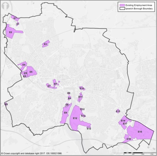
(13) Q37: Land is allocated in the Borough as countryside. Should we re-allocate countryside sites to housing? If not, why not? If yes, which areas? (See map below for details of current countryside areas).
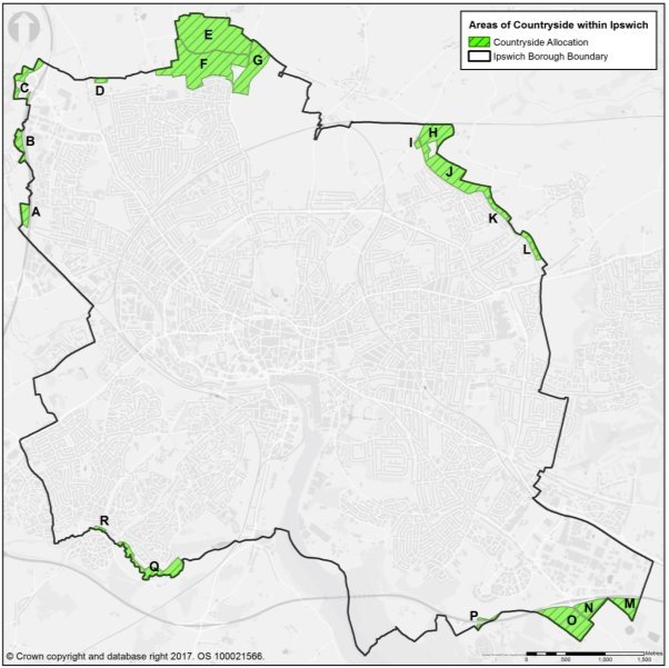
(12) Q38: Land is identified as open space. Should we re-allocate some open space sites to housing? If not, why not? If yes, which ones? (The map below shows all the areas of open space in the Borough).
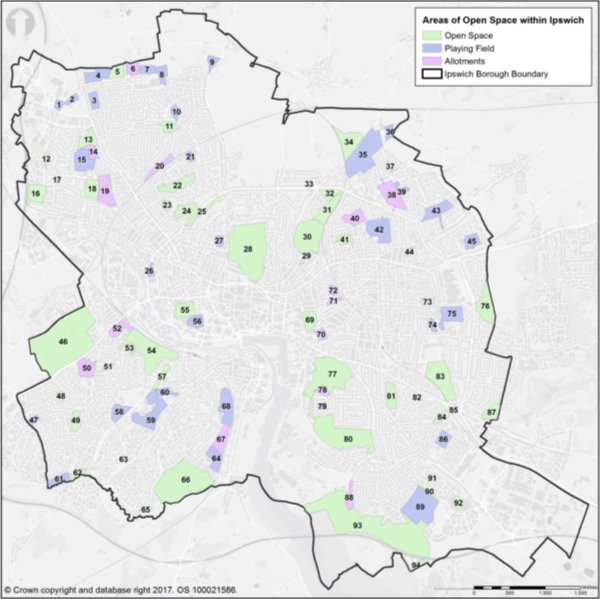
(5) Q39: Are there other sites in the Borough that you consider would be suitable and available for housing or other development? Please provide details. Please note, sites submitted through the call for sites exercise do not need to be re-submitted.
Central Ipswich: IP-One and Ipswich Vision
The IP-One area has been a useful focus for policy and regeneration efforts in central Ipswich. It combines four areas which overlap at the edges, each of which has a customised policy approach:
- the town centre and central shopping area – the focus for retail, leisure and office development with residential uses encouraged on upper floors;
- the Waterfront, a mixed use area of living accommodation, pubs, cafes and restaurants, the hub of the University of Suffolk, office accommodation and boat-related activities;
- this overlaps with the Education Quarter which contains the University of Suffolk and the Suffolk New College, and it is about ensuring these institutions have sufficient space available to meet current and future needs for teaching space, student accommodation and associated activities; and
- Ipswich Village, which is another mixed use area of offices, leisure (including Ipswich Town Football Club's ground at Portman Road), open space and living accommodation, close to the station and the town centre. The delivery of sites allocated through the local plan will increase the number of people living in this area.
IP-One area (plan)
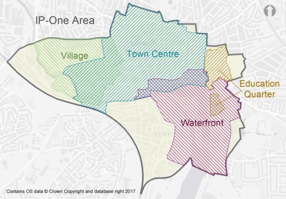
Some policy approaches are nationally prescribed, for example the principle that retail, leisure and office developments are 'main town centre uses' which should be located centrally and controlled elsewhere.
More recently the Ipswich Vision has identified ten smaller quarters across central Ipswich as shown and described below. Whilst they look different from the Local Plan areas, the mix of uses described aligns closely with the four Local Plan policy areas.
Extract from Ipswich Vision Document showing the ten 'quarters' and the expected mix of uses in each quarter.
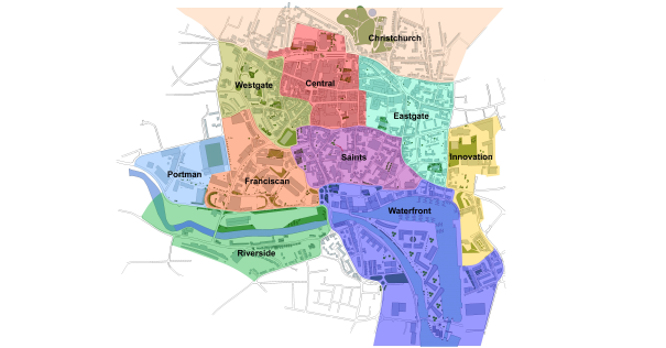
|
The Westgate Quarter – a mixed area including residential, car parking and leisure surrounding the New Wolsey Theatre. |
The Central Quarter – a distinctive retail and leisure offer, with some associated employment uses, all within a predominantly pedestrianised environment. |
The Christchurch Quarter – an area of high value housing clustered around Christchurch Park, the Mansion and the Museum. |
|
The Portman Quarter – an area of commerce, public authorities and complementary employment and sporting uses. |
The Saints Quarter – a mixed area structured around north-south routes bringing together new residential developments with supporting and experimental independent retail and leisure uses. |
The Eastgate Quarter – a mixed area with expanded areas of urban living supplemented by retail, leisure and entertainment uses alongside car parking. |
|
The Franciscan Quarter – an employment area surrounding the new Princes Street office corridor and Cardinal Park, a leisure and entertainment park |
The Waterfront Quarter – the amphitheatre surrounding the marina and incorporating an island site and within which business, enterprise and leisure uses are encouraged |
The Innovation Quarter – an exciting learning and creative area surrounding University Campus Suffolk and Suffolk New College. |
|
The Riverside Quarter – an area to the west of the waterfront incorporating new waterside residential developments, car parking and river walkways leading to and from the station |
|
|
Source: Ipswich Vision in association with Barefoot and Gilles Architects.
(9) Q40: For planning purposes, should we continue with the IP-One approach or align with the Ipswich Vision 'quarters' definitions? In either scenario, are the boundaries and the policy approaches appropriate?
Housing mix, affordability and density
The existing stock of homes in Ipswich is dominated by three-bedroom dwellings which account for 49.9% of the stock, higher than the proportion in the Ipswich Housing Market Area (HMA) (43.4%) and England (41.2%). Two-bedroom dwellings make up another 25.4% of the Ipswich stock, similar to the HMA (25.1%) but lower than England (27.9%). The pie charts below compare the size (by number of bedrooms) of the existing stock in the Ipswich HMA and Ipswich Borough. This includes all kinds of homes – detached, semi-detached, terraced and flatted. The size range of the Ipswich housing stock reflects the age and nature of housing in the Borough: late 19th C and early 20th C terraced housing which generally has two to three bedrooms, and significant inter-war and post-war suburban development of semi-detached and detached homes which tend to have three bedrooms.
Ipswich Housing Market Area consists of the area covered by Ipswich Borough and Babergh, Mid Suffolk and Suffolk Coastal Districts.
The Strategic Housing Market Assessment Part 2 report identifies the housing need in Ipswich Borough by tenure and size. This is reproduced in the figures below. It is set out as a guide to the overall mix of accommodation required in the Borough although it is acknowledged that the Council may wish to divert away from this profile in particular instances. It shows that for market housing, the need is predominantly for three-bedroom dwellings and also two-bedroom and four-bedroom plus dwellings. For discount home ownership and affordable rent, it is a more even spread. Although much recent development in Ipswich has been in the form of apartments, there remains some need for one-bedroom homes in all tenures.
|
Tenure split
|
Size profile
|
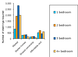
Note to figures: Market housing includes both owner-occupied and private rented
Starter homes figures represent potential demand rather than a requirement
(9) Q41: Should the Local Plan continue to insist on a mix of dwelling sizes and types on each individual site or aim to ensure that we end up with a mix overall, across all development sites in the Borough?
Starter Homes are an emerging government initiative outlined in the Housing and Planning Act 2016. They are aimed at helping first-time buyers under the age of 40 onto the housing ladder through being sold at a discount of at least 20% of the market value. The adopted Local Plan makes some provision for them, for example in employment areas where certain conditions are met. However, now that employment areas have been reviewed through the Employment Land Supply Assessment, it may be appropriate to revert to excluding housing from remaining employment areas under all circumstances.
(2) Q42: Do you consider that 'starter homes' should be allowed as an exception on employment areas? Or should 'starter homes' simply be considered part of an overall mix of housing to be delivered on sites allocated for housing?
The current Local Plan sets out the approach to affordable housing provision. The threshold for provision is developments of 15 dwellings or more and the target for provision is at least 15% (N.B. Ipswich Garden Suburb requires 31%), as a result of viability assessment. Affordable housing completions in the Borough have fluctuated in recent years as overall completions levels have struggled to return to pre-recession levels and funding available to Housing Associations has changed. For the last five years, affordable housing completions in Ipswich have been as follows:
|
Year |
Number of affordable homes completed |
Total dwelling completions |
% of total completions affordable |
|
2011/12 |
152 |
283 |
54% |
|
2012/13 |
7 |
100 |
7% |
|
2013/14 |
44 |
228 |
19% |
|
2014/15 |
202 |
470 |
43% |
|
2015/16 |
133 |
496 |
27% |
|
Total 2011-2016 |
538 |
1,577 |
34% |
The higher percentages delivered over the last two years are due to specific schemes and circumstances, including the Council's own housing scheme at Bader Close and the Stoke Quay scheme which received gap funding from the Homes and Communities Agency. Early monitoring results for 2016/17 indicate that the affordable housing completions level will be significantly lower.
(3) Q43: Should the threshold for affordable housing provision in private market developments or the targets for provision in different parts of the Borough be revised and on what evidence would you base this?
(3) Q44: What do you consider to be an appropriate mix of affordable and private market housing in new developments if viability is not a concern?
The Accommodation Needs Assessment for Gypsies, Travellers, Travelling Showpeople and Boat Dwellers indicates that Ipswich has 39 current, occupied, permanent pitches for Gypsies and Travellers. It identifies a future need for an additional 27 permanent pitches to be provided by 2036, as well as the ongoing work to jointly provide transit pitches across the whole of Suffolk. Gypsies and Travellers can also provide their own privately-owned sites. Currently the Local Plan contains a criteria based approach (Policy CS11) to guide the location of sites, which is intended to ensure that the sites are safe and accessible and reasonably close to community facilities including schools.
(4) Q45: Where should additional permanent pitches for Gypsies and Travellers be allocated?
(1) Q46: Should the current criteria-based policy for assessing applications for Gypsy and Traveller sites be changed?
There are currently over 4,500 full and part-time students studying at the University of Suffolk equating to a full-time equivalent of 3,200 students. Just over 15% of students require accommodation, with 573 resident in on-campus halls of residence, 137 living in off-campus halls of residence and 37 in the local private rented sector. Some 70% of the student population base are from the local area (from within the four closest post code areas (IP, CO, NR, PE)) and the majority of these are thought to be living at their parents' home whilst studying. The private rented accommodation occupied by students is located within one mile of the waterfront campus and there are no notable problems with students in relation to housing currently. The University has plans to grow, but the additional impact on the local housing market arising from the University is likely to be small.
The current Local Plan aims to control the proliferation of many Houses in Multiple Occupation (HMOs) in a small area, insofar as it can be controlled through planning policy. HMOs can be occupied by any sector of the population.
(1) Q47: Is this approach proving effective or are there residential areas where the number of people living in HMOs is considered excessive? Should the policy approach be continued and if so what proportion of shared dwellings should be permitted in any one street?
Homes can be built at a range of different densities, which is measured as dwellings per hectare. The Local Plan seeks to control the density of development in order to ensure that land is used efficiently. The strategic approach to density as a potential source of additional housing is addressed through the Part 1 Issues and Options. The local approach to density in Ipswich has been to require high density development in the town centre, Ipswich Village and Waterfront; medium density in the rest of IP-One and in and around district centres; and low density elsewhere (Policy DM30). As an indication, the density of the Ravenswood development is around 39 dwellings per hectare, which is on the cusp between low and medium density.
(2) Q48: Should the Council continue this approach to the density of residential development?
Employment
The Local Plan Part 1 Strategic Issues and Options asks whether employment land should be considered as a source of land for additional housing provision in Ipswich, because of the tightly drawn boundary around the Borough. Ipswich has a challenging jobs forecast of 19,040 jobs to be delivered between 2014 and 2036 (from the East of England Forecasting Model 2016). The Employment Land Supply Assessment (ELSA) has converted this into a calculation of land needed for employment uses. The starting point for net employment land need in the Borough is around 28 hectares (ha), which is approximately half of the land area that the current adopted Local Plan allocates for employment use.
However, this starting point figure does not take account of the need to provide a range of sites of different sizes in different locations and ensuring that there is enough land of the right quality. Some of the land and premises being vacated and factored into the net calculation may be unfit for purpose. The land estimate is also a 'business as usual' projection of recent economic trends rather than reflecting any growth ambitions.
Whilst it is unlikely that changing land from employment to housing use within the Borough would deliver sufficient land to accommodate the Objectively Assessed Needs for housing, there may be allocated employment sites which could be suitable for residential use (see question 36).
The Council's own monitoring of the Employment Areas such as Whitehouse and Ransomes Europark shows that occupancy rates have increased over the last year. The areas provide an important source of land and premises for local businesses and offer sites away from sensitive uses such as homes, whose occupants could be disturbed by 24 hour operation or by odour. The monitoring also reveals the extent of localised 'churn' in occupation which takes place from year to year as businesses seek to expand or contract. The Employment Areas fulfil a vital function in allowing this element of flexibility in the local market.
(5) Q49: The current Local Plan allows for uses such as small gyms or cafes to provide local services for the workforce, and car showrooms within the Employment Areas. Is this the right approach?
(13) Q50: Should all the sites allocated for employment use be protected from residential or other uses?
(6) Q51: Should the Council allocate more employment land than is needed to ensure choice?
The current Local Plan allows a degree of flexibility over land uses in employment areas and existing employment sites outside the Employment Areas, provided a marketing exercise is undertaken to demonstrate that the site is not needed for business, industrial or storage and distribution uses.
(2) Q52: What marketing should we require to prove redundancy of a site for business, industry or storage and distribution?
Infrastructure and Transport
National planning policy requires that we plan positively for the housing and jobs development needed in the area and also the infrastructure needed to support it. Infrastructure includes a wide range of facilities and services which support daily life. An effective transport system is key to ensuring places are successful.
Currently infrastructure is planned for and delivered in a number of ways. The Local Plan identifies infrastructure items for which land needs to be safeguarded, for example sites are identified for new schools and surgeries in the adopted Local Plan. Infrastructure is currently largely delivered in Ipswich through negotiated planning obligations at the time of a planning permission or via central Government funding. The Council does not have a Community Infrastructure Levy, which is a tariff charged per square metre of new development and is subject to exemptions.
(4) Q53: Is the current system of funding infrastructure effective? Should the Council consider introducing a tariff-based charge to fund infrastructure?
At a strategic level, the congestion problems experienced in Ipswich when the Orwell Bridge closes are well documented. There are currently two projects underway exploring alternative options for east-west routes: the Ipswich Northern Routes Study and the Upper Orwell Crossings Study. Strategic transport issues are explored through the Local Plan Part 1 Strategic Issues and Options.
A number of factors have led to increased congestion in certain parts of the town, as the existing network struggles to handle the impact of an increased population within the town and the wider residential areas that surround it.
(17) Q54: How best can we tackle congestion in Ipswich?
Ipswich is a compact town, which lends itself to walking and cycling. However, car ownership, whilst lower than the average in Suffolk, has increased from 1 car per household in 2001 to 1.06 cars per household in 2011 and travel to work information indicates that cars still dominate. It is thought that one reason behind the growth in car based commuting between 2001 and 2011 may have been that Ipswich residents were having to commute further to jobs outside the Borough.
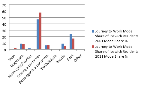
Source: WSP, Ipswich Census Data Trend Analysis, 2014/15, percentages total 99.9% likely due to rounding (ICD48b)
Congestion is a problem for everybody. It impacts on the economy, the environment and health. For some journeys the car may be the only realistic, safe and practical choice. For other journeys, there is potential for people to use public transport, or to walk and cycle, which could be supported through the way developments are planned.
(12) Q55: How can sustainable modes of transport be encouraged?
In central Ipswich, the shopping centre focused around Tavern Street and the Corn Hill is separated from the Waterfront by the gyratory system of Star Lane and College Street / Key Street, which deters pedestrians and contributes to one of the Borough's larger Air Quality Management Areas. The gyratory, which is a busy dual carriageway, hampers delivery of the Ipswich Vision of a 'Waterfront Town Centre' and detracts from the setting of valued medieval buildings and structures, including the three waterfront churches and Wolsey's Gate.
The gyratory is also one of only three east-west routes available in the town because of the river and the historic core: the gyratory, St Matthew's Street / Crown Street / St Helen's Street, and Colchester Road.
The Council is not the Highway Authority and therefore cannot plan roads – this falls to Suffolk County Council. However, through successive local plans, and working with Suffolk County Council, Ipswich Borough Council has encouraged work to explore ways to enhance east-west transport capacity in order to enable improvements to pedestrian and cycle routes between the Waterfront and the historic core of the town.
(7) Q56: What changes, if any, would you like to see to the gyratory?
Creating new road space is not the only solution. Public transport is effective at getting people from the periphery of the town to the centre but not in making more circular journeys (e.g. from Chantry to Ransomes Industrial Estate). Bus services in some parts of the town operate with frequencies which are lower than is desirable and may be absent in the evenings and on Sundays. This is particularly important when considering people's ability to use public transport to reach key peripheral destinations such as the hospital and Ransomes in the east or Whitehouse Employment Area in the west.
(11) Q57: What new transport infrastructure or services do you think are needed to support further growth in Ipswich?
The new Local Plan will look to the future – to 2036. By then we may all be growing accustomed to driverless vehicles or electric vehicles as standard. Hydrogen-powered vehicles are also a possibility, and electric bicycles may be the norm.
(4) Q58: What type of transport infrastructure for the future, such as electric charging points, should we plan for?
Car parking provision is often debated. The current approach to car parking in central Ipswich is to focus short stay shopper parking in the 'Central Car Parking Core' which is shown on the map below. This is to support the retail and leisure functions of the town centre. Long stay commuter parking is provided outside the core. This policy approach is also aimed at encouraging commuters to use more sustainable modes and some employers back this up with green travel plans offering subsidised public transport to workers, for example.
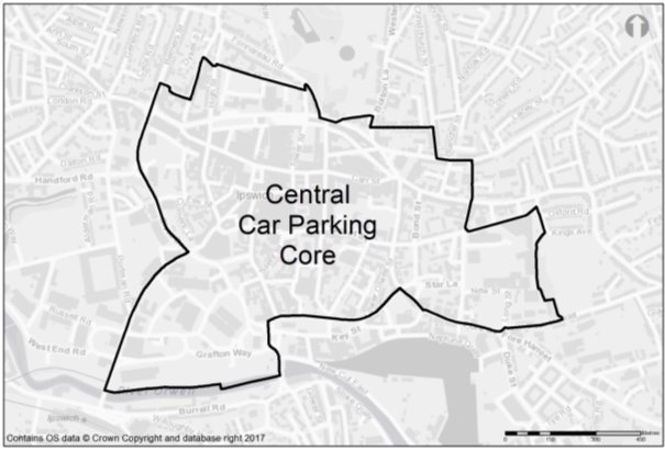
(6) Q59: What should be the approach to planning for long stay commuter parking and short stay shopper parking in central Ipswich?
(3) Q60: Is the boundary of the Central Car Parking Core in the right place?
(5) Q61: Are additional car parks needed to serve town centre shops or leisure facilities? If so, where?
Town, District and Local Centres
The town centre and Central Shopping Area boundaries are defined in the adopted Local Plan and shown in the plan below. The Central Shopping Area is the part of the town centre where shopping (in retail use i.e. Class A1) is the primary land use. By keeping shopping activities within a relatively small area, people can browse on foot and compare goods and prices from shop to shop before making purchases. Some related activities are also permitted within the Central Shopping Area, such as cafes, banks and estate agents (use classes A2 to A5). More recently some larger leisure uses have also been permitted within the Central Shopping Area, for example at the Buttermarket Centre. The uses in the Central Shopping Area are controlled by defining Primary, Secondary and Specialist retail frontages through the Local Plan with policies to control the mix of uses in each frontage. The more extensive town centre outside the Central Shopping Area is the current focus for office, cultural and leisure activities, such as theatres, museums and Cardinal Park. In both areas, residential use is also encouraged – above shops in the Central Shopping Area and in mixed use schemes within the town centre. Mixing uses can help to maintain levels of activity and make places feel vibrant, fun and safe to be in so that when office workers go home, there are still other people around, living in the area or enjoying leisure activities.
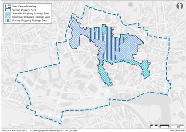
(4) Q62: Do you agree that the town centre and Central Shopping Area boundaries are drawn in the right place? Which streets would you like to see included within the Central Shopping Area - or excluded from it?
(2) Q63: Should the Council continue to define the Central Shopping Area as Primary and Secondary and Specialist retail frontages to control the mix of uses?
The adopted Local Plan allocates the former Civic Centre and Police Station site on Civic Drive, known as Westgate, for major retail-led development with larger retail stores, and an element of housing.
(4) Q64: Should the Westgate site continue to be allocated for large-scale retail development or should other uses be pursued?
The current Local Plan controls the development of new shops with a floor area larger than 200 sq m outside the Central Shopping Area and District Centres, as larger shops would compete with the centres. New retail proposals larger than 200 square metres (net) outside of defined centres therefore have to undertake a full retail impact assessment on the centres.
(1) Q65: Should the threshold be changed? If you support a different threshold, please explain why.
There are currently 11 district centres in Ipswich with a further two not yet developed at Sproughton Road and the Ipswich Garden Suburb (see map overleaf). District and Local Centres perform an important role serving the day to day food and services needs of local residents. With regard to District Centres, the Retail and Commercial Leisure Study suggests that they have low vacancy and are vital and vibrant. They vary quite widely in their character, for example Stoke Park is now dominated by a single store and Ravenswood is purpose built, whereas Woodbridge Road is more dispersed and has shops interspersed with houses.
(3) Q66: Should we continue to protect all of the district centres?
(1) Q67: Should we be planning for the expansion of any of the district centres, if so where?
Q68: Should the District Centre allocation at Sproughton Road be extended to include the Morrisons store and the Namco Funscape bowling alley building on the other side of Sproughton Road?

There are 34 local centres in Ipswich of varying size, scale and vibrancy.
(1) Q69: Should we continue to protect all of these local centres? Do they still provide the function intended of them? Do any need re-allocating to different uses, or extending?
The current Local Plan also seeks to focus community facilities into centres, for example GP surgeries, schools and early years provision, so that people can make linked trips, e.g. pick up some groceries after visiting the doctor. This also informed the approach to housing density which is highest near centres. If more people live within walking distance of the facilities they need, it can help make sustainable transport choices more realistic.
Q70: Should this locational approach to community facilities continue?
The loss of pubs has been a concern in Ipswich. The Council currently requires a marketing strategy to be undertaken for a minimum of 12 months prior to applying for planning permission for change of use or redevelopment of a pub, in order to show that the use has no viable future.
(2) Q71: Do you agree with the approach taken to protecting pubs? If not, what measures would you like to see put in place?
Tourism
Ipswich has plenty to offer the visitor throughout the year and has seen an increase in hotel provision in recent years. Beyond the museum, art gallery, theatre and concert venues, Ipswich also provides a packed calendar of cultural events throughout the year. It is estimated that approximately £34 million of tourism related income arrives in central Ipswich annually. However this figure forms only a small proportion of the overall tourism related income for the County.
(10) Q72: How can Ipswich continue to increase its offer as a tourist destination?
(2) Q73: Do you consider the range of hotels in the town offer the appropriate mix and choice to visitors?
Climate change and flood risk
The Ipswich Flood Defence Barrier is due to be completed in early 2018, which will reduce the risk of flooding to homes and businesses in Ipswich. It is likely, however, that there will still be a risk of pluvial (rainwater) flooding from heavier storms.
(6) Q74: How can we adapt to pluvial flooding through design?
Sustainable Drainage Systems (SuDS) are designed to reduce the potential of new and existing developments with respect to surface water drainage, avoiding the need to use conventional pipes. They can take the form of swales, permeable surfaces, green roofs, soakaway infiltration structures, basins, ponds, or underground storage.
(5) Q75: What is your experience of SuDS? Are they successful and an efficient use of space? What is their long-term effectiveness?
As temperatures rise in urban areas, adaptations can be made to the built environment to make a more pleasant environment, for example more shading from trees.
(3) Q76: What measures do you consider can be introduced into urban areas to address climate change?
The energy performance of new residential buildings and their construction methods are now dealt with via Building Regulations. However, the Council is still able to encourage lower energy and water usage in new developments.
(2) Q77: How can we encourage new developments to reduce carbon emissions and be climate change resilient? Should we require development to meet higher standards of energy efficiency and lower levels of water usage?
The NPPF requires Councils to consider identifying areas for renewable and low carbon energy development. The nature of the Borough rules out extensive uses such as wind farms and solar farms. Notwithstanding this, measures such as solar panels on roofs are possible at the building scale.
(2) Q78: What measures should be encouraged to provide renewable and low carbon energy development within Ipswich?
Design
There is a strong approach to the design of buildings and the environment in Ipswich. Tools that are available to support the implementation of design policies include Building for Life 12, which sets 12 criteria to assess the design quality of homes and neighbourhoods. Lifetime neighbourhoods are promoted by the Government. These are neighbourhoods designed to be accessible for all regardless of age or disability. For land use planning, it means thinking about the mix of residential, retail and employment uses to ensure affordable, safe and inclusive access to a range of services; outdoor spaces and buildings that promote social contact; and locally accessible greenspace and natural environments.
(12) Q79: What in your opinion makes a well-designed development? Do you feel that high quality design is being delivered in Ipswich?
(3) Q80: Should Building for Life 12 continued to be used as a tool to improve the design quality of new development?
Ipswich contains some clusters of tall buildings. The area around the Civic Drive and Greyfriars was developed in the 1960s and, more recently, high rise development has taken place on the Waterfront. High rise building is an efficient way to use land, but its impacts on townscape, amenity and the historic environment need to be carefully considered.
(10) Q81: Do you think the tall buildings around the Waterfront enhance the vibrancy of the area? Are there other areas of the town where additional tall buildings (of appropriate construction standards) would be appropriate?
Street trees often enhance the appearance of transport corridors and quiet streets. The plane trees on Yarmouth Road are a distinctive feature of the townscape and new trees have been planted in the town centre, for example at Giles Circus and as part of the Princes Street junction improvements. There is a cost associated with maintaining street trees, for example ensuring that fallen leaves do not obstruct road drains. Trees on development sites are currently protected through the Local Plan, which requires any mature trees felled to be replaced with two new ones. Other existing trees including in private gardens can be protected through tree preservation orders which operate outside the Local Plan system.
(8) Q82: Do you feel more protection should be given to street trees? Do you have specific examples of trees which should be protected?
For some new visitors arriving in Ipswich, particularly by car, it may not be obvious when they have reached the town centre. For example, entering the town across Stoke Bridge or St Matthew's roundabout, it may not be immediately clear that it is the edge of the town centre. One way to reinforce the 'gateway' nature of such locations is to take a particular design approach to buildings.
(2) Q83: Do you feel there needs to be greater attention to the architectural design of buildings in these locations?
Historic Environment
Ipswich has a rich heritage, in particular from the Anglo-Saxon period, and has a medieval street pattern. There are over 600 listed buildings, ten scheduled monuments, 15 conservation areas and three registered parks, gardens and cemeteries. Ipswich Borough Council also has a Local List of Buildings of Townscape Interest and a number of Urban Character Studies for areas of the Borough. There is a central area of archaeological importance and an Ipswich Urban Archaeological Database is being prepared.
National planning policy requires Local Plans to set out a positive strategy for the protection and enhancement of the historic environment.
(6) Q84: What could be included in a positive strategy in the Local Plan to protect and enhance heritage assets?
(2) Q85: Are the existing measures to control development in conservation areas effective, for example requesting that new shopfronts be constructed from high quality materials and respect the character and appearance of the building and street scene? Are there any other ways we can enhance conservation areas?
(1) Q86: Are there additional areas which you consider should be designated as conservation areas?
(2) Q87: How could our archaeological assets be protected?
(5) Q88: How can Ipswich better utilise its heritage assets and archaeology?
(5) Q89: How should the Waterfront be further developed as a heritage feature of the town?
Open space and biodiversity
There are many areas of open space within the Borough, across a range of types and sites, including formal parks, allotments, playing fields and the Orwell Country Park. The Council has an adopted approach to the provision and protection of open space through applied standards per population. Currently, larger development sites are required to incorporate on-site open space provision, whereas smaller developments may make a financial contribution which allows an existing facility to be enhanced. The cost of maintaining open spaces needs to be considered, as maintaining a large number of small spaces is less efficient that maintaining fewer large areas of open space.
(8) Q90: Should the Council continue to apply a standards approach to the provision of new open space per head of population?
(7) Q91: Is your perception that there is too much, too little or about the right amount of open space in the Borough?
(4) Q92: There is a deficit of provision for teenagers – facilities such as teen shelters and multi-use games areas. What sort of provision should be made and where?
(10) Q93: There is a deficit of Accessible Natural Greenspace in north Ipswich. A new country park at the Ipswich Garden Suburb will be provided as the development is built out. Do you feel there is a need for more Accessible Natural Greenspace in addition to this in north Ipswich?
(5) Q94: What is the minimum size of development which should be required to provide on-site open space?
(4) Q95: Which models for managing open spaces are effective?
The current Local Plan proposes the establishment of a 'green rim' around Ipswich to provide recreational access to the countryside and a wildlife corridor. The proposal originated from the Haven Gateway Green Infrastructure Study in 2008. However to date it has remained a general concept rather than being geographically defined on a map.
(6) Q96: Are there existing routes around the fringe of Ipswich for cycling and walking that could form the core of the green rim? How wide would the green rim need to be in order to be an effective recreational and wildlife resource?
Ipswich has developed a Wildlife Network to support biodiversity in the town and opportunities for people to have contact with the natural world, which is beneficial to health and wellbeing. There are many initiatives in Ipswich to support biodiversity, ranging from the Greenways Project to the Ipswich hedgehog officer to 'Urban Buzz', a project dedicated to supporting pollinating insects, which are in serious decline. Urban areas provide important opportunities for habitat creation, including through new developments. The Local Plan also protects existing designated habitats ranging from the internationally protected Orwell Estuary Special Protection Area to the Local Nature Reserve at Piper's Vale.
(5) Q97: How can the Ipswich Wildlife Network be further enhanced and linked into surrounding areas?
(6) Q98: Should more areas of the Borough be designated as Local Nature Reserves, and if so where?
Sport and Leisure
Ipswich has many sport and leisure facilities in the town centre and around the Borough. These include swimming pools, sports centres, cinemas and theatres.
(15) Q99: Does Ipswich offer the appropriate mix of sport and leisure facilities you would expect in a town of its size? What other facilities could it offer?
Demography, social inclusion and health
The proportion of 'elderly' households in Ipswich is increasing. Given the growth in the older population, changes in the social care system and the higher levels of disability and health problems amongst older people there is likely to be an increased requirement for specialist housing options in future.
Ipswich also has a younger demographic profile than the neighbouring districts. Young people may struggle to afford to buy/rent a home of their own and may therefore opt to stay at home for longer. Both of these factors could increase the demand for larger dwellings to accommodate multiple generations of a family.
(5) Q100: How should we best plan for an ageing population in the Borough?
(2) Q101: The current Local Plan safeguards land for new or extended primary schools and sets out standards for children's play provision. Are other planning responses needed for the relatively younger demographic in Ipswich?
21.5% of all children in Ipswich live in income deprived households and income deprivation runs at 16.3% of all people in Ipswich. Both of these figures are higher than Suffolk averages.
Currently there are several ways in which planning policy responds to deprivation within the Ipswich community. One is to protect employment areas across the whole Borough so that jobs are potentially available close to where people live. The Local Plan also promotes accessibility to new development by a range of modes of transport so that it is not car dependent. This is significant in a Borough where nearly 28% of households do not have a car or a van. The Local Plan also ensures that land is safeguarded for new schools where needed and protects the Education Quarter.
(3) Q102: In what other ways could the land use plan help to tackle issues of deprivation and inequality in Ipswich?
Health inequalities are present in Ipswich. The Local Plan already includes a number of measures which can impact positively on health through identifying sites for GP surgeries, enabling housing to be delivered, ensuring a good quality of development, protecting open spaces and encouraging more active modes of transport.
(6) Q103: How else should the Local Plan tackle health inequalities?
The way in which health services are delivered is changing. GP surgeries are being brought together into fewer, larger facilities.
Q104: What criteria should guide the location of such facilities? Should they be located in District Centres?
Q105: Are there sites or locations where you think they are needed?
Any other issues?
(12) Q106: Parts 1 and 2 of this consultation paper have considered many different issues affecting Ipswich. Are there any other issues not mentioned here, which relate to land use in Ipswich, about which you would like to comment?
[1] Babergh and Mid Suffolk Joint Annual Monitoring Report 2016-2017, June 2017
[2] Babergh and Mid Suffolk Joint Annual Monitoring Report 2016-2017, June 2017
[3] Sites with a resolution to approve subject to a Section 106 are not included within monitoring figures for Suffolk Coastal District Council, as most are already included in the figure for dwellings on allocated sites.
[4] https://www.suffolk.gov.uk/roads-and-transport/transport-planning/consultations-and-studies/